Toledo Bend Reservoir is a
reservoirA reservoir , artificial lake or dam is used to store water.Reservoirs may be created in river valleys by the construction of a dam or may be built by excavation in the ground or by conventional construction techniques such as brickwork or cast concrete.The term reservoir may also be used to...
on the
Sabine RiverThe Sabine River is a river, long, in the U.S. states of Texas and Louisiana. In its lower course, it forms part of the boundary between the two states and empties into Sabine Lake, an estuary of the Gulf of Mexico. The river formed part of the United States-Mexican international boundary during...
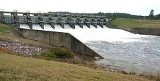
between Texas and Louisiana. The lake has an area of 185,000
acreThe acre is a unit of area in a number of different systems, including the imperial and U.S. customary systems. The most commonly used acres today are the international acre and, in the United States, the survey acre. The most common use of the acre is to measure tracts of land.The acre is related...
s (749 km²), the largest man-made body of water in (or partially in) Texas, the largest in the South, and the fifth largest (surface acre) in the United States. The dam is capable of generating 92 megawatts of electrical power. The dam itself is located in the northeast corner of
Newton County, TexasNewton County is the easternmost county in the U.S. state of Texas. In of 2000, its population was 15,072. Its county seat is Newton. Newton county is named for John Newton, a veteran of the American Revolutionary War...
; however, that county includes very little of the reservoir, as most of it extends northward into parts of
SabineSabine Parish is a parish located in the U.S. state of Louisiana. The seat of the parish is Many. In 2010, the parish's population was 24,233....
and DeSoto parishes in Louisiana, and
Sabine,
Shelby*Arcadia*Brooklyn*Center*Dreka *Huxley*Joaquin*Possum Trot*Shelbyville *Tenaha*Timpson*Weaver-Education:The following school districts serve Shelby County:*Center ISD*Excelsior ISD...
, and
PanolaAs of the census of 2000, there were 22,756 people, 8,821 households, and 6,395 families residing in the county. The population density was 28 people per square mile . There were 10,524 housing units at an average density of 13 per square mile...
counties in Texas.
Historical development
The land along the
OrangeOrange is a city in Orange County, Texas, United States. As of the 2000 census, the city population was 18,643. It is the county seat of Orange County, and is the easternmost city in Texas. Located on the Sabine River at the border with Louisiana, it is part of the Beaumont–Port Arthur...
area often flooded from the Sabine, with destructive effects. Also, the considerations for municipal, industrial, agricultural, and recreational purposes were part of the reasons the Texas State Legislature formed the
Sabine River Authority of Texas in 1949, and in 1950 the
Louisiana State LegislatureThe Louisiana State Legislature is the state legislature of the U.S. state of Louisiana. It is bicameral body, comprising the lower house, the Louisiana House of Representatives with 105 representatives, and the upper house, the Louisiana Senate with 39 senators...
created the
Sabine River Authority, State of Louisiana for the project.
With both authorities in agreement, in 1955 a feasibility report was initiated and by 1959, the two states allocated 30 million dollars for the project. The land was acquired in 1963, with the work following the subsequent year. The
Massman-Johnson Construction Company served as the general contractor, and by the completion of the project in 1969, Texas’ estimated share of the funds was $70 million. The dam was built by the two states, without any assistance from the federal government. Louisiana Director of
Public WorksPublic works are a broad category of projects, financed and constructed by the government, for recreational, employment, and health and safety uses in the greater community...
Claude KirkpatrickClaude Kirkpatrick was a diversified businessman who served two terms in the Louisiana House of Representatives , worked to establish Toledo Bend Reservoir through his directorship of the state Department of Public Works , and was the administrator and then president of Baton Rouge General Medical...
, who was also president of the Sabine River Authority of Louisiana at the time, pushed for the joint agreement with Texas, in the absence of federal funds, to make the project a reality.
The Toledo Bend legislative bill was successfully pushed despite numerous obstacles by freshman Representative
Cliff AmmonsClifton R. Ammons , known as Cliff Ammons, was an educator and businessman from Many, Louisiana, who served from 1960-1964 as a Democrat from Sabine Parish in the Louisiana House of Representatives...
of
ManyMany is a town in and the parish seat of Sabine Parish, Louisiana, United States. The population was 2,889 at the 2000 census. The town was named for John B. Many, the commander of nearby Fort Jesup.-History:...
, the seat of Sabine Parish. Funding came from Constitutional Amendment 8, which tapped previous funds for
Civil WarThe American Civil War was a civil war fought in the United States of America. In response to the election of Abraham Lincoln as President of the United States, 11 southern slave states declared their secession from the United States and formed the Confederate States of America ; the other 25...
pensions into the specific reservoir project.
Though Ammons became known as "the father of Toledo Bend," voters defeated him in the 1964 state legislative election.
History
Beginning in May 1963, land acquisitions for Toledo Bend Reservoir started as a joint management project of Texas and Louisiana River Authorities. Construction on the
Toledo Bend Dam, spillway, and power plant, began on May 11, 1964. The closure section of the earthen embankment and impoundment of water was begun in October 1966. The power plant was completed and began operating in the early part of 1969. The Toledo Bend Project was constructed primarily for the purposes of water supply, hydroelectric power generation, and recreation.
Toledo Bend Reservoir forms a portion of the boundary between the states of Texas and Louisiana. From the dam site, which is north of Burkeville, TX, the reservoir extends up the river for about 65 miles (105 km) to Logansport, LA, and inundates land in Sabine, Shelby, Panola and Newton Counties, Texas, and Sabine and DeSoto Parishes, Louisiana.
The water, normally covering an area of about 200000 acres (809.4 km²) has a controlled storage capacity of 4477000 acre.ft.
One of a kind
Toledo Bend is the nation's only public water conservation and hydroelectric power project to be undertaken without federal participation in its permanent financing.
Public recreation
Toledo Bend, with its 1200 miles (1,931.2 km) of shoreline, offers an almost unlimited opportunity for recreational development and is a major element in serving the growing demand for water oriented outdoor recreation. Both private and public facilities are available for swimming, boating, picnicking, fishing, camping, hunting and sightseeing. The reservoir is a popular location for freshwater fishing with many clubs hosting tournaments.
At present, the lake is best suited to shallow draft power boats due to a large number of trees and stumps that are still in the body of the lake. Although there are numerous well marked boat lanes that have been cleared of stumps and trees, one should use caution even on the boat lanes; one should use extreme caution when off the boat lanes and maintain a watch for stumps and/or trees as well as floating logs.
http://www.toledo-bend.com/toledo_bend/index.asp?request=buoys
External links