
AH1
Encyclopedia

Asian Highway Network
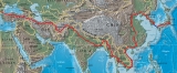
The Asian Highway project, also known as the Great Asian Highway, is a cooperative project among countries in Asia and Europe and the United Nations Economic and Social Commission for Asia and the Pacific , to improve the highway systems in Asia...
, running 12,845 miles (20,557 km) from Tokyo, Japan via Korea
Korea
Korea ) is an East Asian geographic region that is currently divided into two separate sovereign states — North Korea and South Korea. Located on the Korean Peninsula, Korea is bordered by the People's Republic of China to the northwest, Russia to the northeast, and is separated from Japan to the...
, China
China
Chinese civilization may refer to:* China for more general discussion of the country.* Chinese culture* Greater China, the transnational community of ethnic Chinese.* History of China* Sinosphere, the area historically affected by Chinese culture...
, Southeast Asia
Southeast Asia
Southeast Asia, South-East Asia, South East Asia or Southeastern Asia is a subregion of Asia, consisting of the countries that are geographically south of China, east of India, west of New Guinea and north of Australia. The region lies on the intersection of geological plates, with heavy seismic...
, India
India
India , officially the Republic of India , is a country in South Asia. It is the seventh-largest country by geographical area, the second-most populous country with over 1.2 billion people, and the most populous democracy in the world...
, Pakistan
Pakistan
Pakistan , officially the Islamic Republic of Pakistan is a sovereign state in South Asia. It has a coastline along the Arabian Sea and the Gulf of Oman in the south and is bordered by Afghanistan and Iran in the west, India in the east and China in the far northeast. In the north, Tajikistan...
, Afghanistan
Afghanistan
Afghanistan , officially the Islamic Republic of Afghanistan, is a landlocked country located in the centre of Asia, forming South Asia, Central Asia and the Middle East. With a population of about 29 million, it has an area of , making it the 42nd most populous and 41st largest nation in the world...
and Iran
Iran
Iran , officially the Islamic Republic of Iran , is a country in Southern and Western Asia. The name "Iran" has been in use natively since the Sassanian era and came into use internationally in 1935, before which the country was known to the Western world as Persia...
to the border between Turkey
Turkey
Turkey , known officially as the Republic of Turkey , is a Eurasian country located in Western Asia and in East Thrace in Southeastern Europe...
and Bulgaria
Bulgaria
Bulgaria , officially the Republic of Bulgaria , is a parliamentary democracy within a unitary constitutional republic in Southeast Europe. The country borders Romania to the north, Serbia and Macedonia to the west, Greece and Turkey to the south, as well as the Black Sea to the east...
west of Istanbul
Istanbul
Istanbul , historically known as Byzantium and Constantinople , is the largest city of Turkey. Istanbul metropolitan province had 13.26 million people living in it as of December, 2010, which is 18% of Turkey's population and the 3rd largest metropolitan area in Europe after London and...
.
Japan
The 750-mile (1200-kilometer) section in Japan was added to the system in November 2003. It runs along the following tolledToll road
A toll road is a privately or publicly built road for which a driver pays a toll for use. Structures for which tolls are charged include toll bridges and toll tunnels. Non-toll roads are financed using other sources of revenue, most typically fuel tax or general tax funds...
expressways
Expressways of Japan
The expressways of Japan make up a large network of freeway-standard toll roads.- History :Following World War II, Japan's economic revival led to a massive increase in personal automobile use...
:
- Shuto ExpresswayShuto Expresswayis a network of toll expressways in the Greater Tokyo Area of Japan. It is operated and maintained by the .Most routes consist of elevated roadway above other roads or over water, and have many sharp curves which require caution to drive safely...
C1 Inner Circular RouteInner Circular Route (Shuto Expressway)The , signed as Route C1, is one of the routes of the Shuto Expressway system serving the central part of the Greater Tokyo Area. The route runs as a complete loop around the central Tokyo wards of Chiyoda, Chūō, and Minato, with a total length of . In addition to serving areas of central Tokyo,...
, Edobashi JCT to Tanimachi JCT via Takebashi JCT -
 Shuto Expressway Route 3 Shibuya LineRoute 3 (Shuto Expressway)Route 3 is one of the radial routes of the Shuto Expressway system in the Tokyo area. Route 3 runs southwest from Tanimachi Junction in Minato-ku and runs for 7.44 miles through Shibuya-ku, Meguro-ku, and Setagaya-ku...
, Tanimachi JCT to Yoga Exit (Tokyo Interchange) -
 Tōmei ExpresswayTomei ExpresswayThe is a national expressway on the island of Honshū in Japan. It is operated by Central Nippon Expressway Company. It is a part of Asian Highway Network -Naming:The word Tōmei is an acronym consisting of two kanji characters...
, Tokyo Interchange to Nagoya 35°41′29.5"N 139°45′22.9"E (approx.) -
 Meishin ExpresswayMeishin ExpresswayThe is a toll expressway in Japan. It runs from a junction with the Tomei Expressway in Nagakute, Aichi west to Nishinomiya, Hyōgo . It is the main road link between Osaka and Nagoya, and, along with the Tōmei Expressway, forms the main road link between Osaka and Tokyo...
, Nagoya to OsakaOsakais a city in the Kansai region of Japan's main island of Honshu, a designated city under the Local Autonomy Law, the capital city of Osaka Prefecture and also the biggest part of Keihanshin area, which is represented by three major cities of Japan, Kyoto, Osaka and Kobe...
via KyotoKyotois a city in the central part of the island of Honshū, Japan. It has a population close to 1.5 million. Formerly the imperial capital of Japan, it is now the capital of Kyoto Prefecture, as well as a major part of the Osaka-Kobe-Kyoto metropolitan area.-History:... -
 San'yō Expressway, Osaka to Shimonoseki
 - Kanmonkyo BridgeKanmonkyo BridgeThe Kanmonkyo Bridge is a suspension bridge crossing the Kanmon Straits, a stretch of water separating two of Japan's four main islands...
, Shimonoseki to Kitakyushu -
 Kyūshū ExpresswayKyushu Expressway' is one of the Expressways of Japan from Kitakyūshū to west of Kagoshima linking with the Higashi Kyushu Expressway and the Ibusuki Skyline. It runs through the prefectures of Fukuoka, the eastern half of the Saga, Kumamoto, Miyazaki and the Kagoshima prefectures. The freeway runs entirely on...
, Kitakyushu to FukuokaFukuoka, Fukuokais the capital city of Fukuoka Prefecture and is situated on the northern shore of the island of Kyushu in Japan.Voted number 14 in a 2010 poll of the World's Most Livable Cities, Fukuoka is praised for its green spaces in a metropolitan setting. It is the most populous city in Kyushu, followed by... -
 Fukuoka Expressway Route 4
 -
 Fukuoka Expressway Route 1
From Fukuoka, AH1 takes the Camellia Line ferry
Ferry
A ferry is a form of transportation, usually a boat, but sometimes a ship, used to carry primarily passengers, and sometimes vehicles and cargo as well, across a body of water. Most ferries operate on regular, frequent, return services...
to Busan
Busan
Busan , formerly spelled Pusan is South Korea's second largest metropolis after Seoul, with a population of around 3.6 million. The Metropolitan area population is 4,399,515 as of 2010. It is the largest port city in South Korea and the fifth largest port in the world...
, South Korea
South Korea
The Republic of Korea , , is a sovereign state in East Asia, located on the southern portion of the Korean Peninsula. It is neighbored by the People's Republic of China to the west, Japan to the east, North Korea to the north, and the East China Sea and Republic of China to the south...
. The Korea-Japan Tunnel has been proposed to provide a fixed crossing.
South Korea
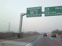
Gyeongbu Expressway
The Gyeongbu Expressway is the second oldest and most heavily travelled expressway in South Korea, connecting Seoul to Suwon, Daejeon, Gumi, Daegu, and Busan. It has the route number 1, signifying its role as South Korea's most important expressway...
.
- Chungjangno: Busan Port (Jung-gu, Busan) - Dong-gu, Busan
- This line is a part of Busan city route 71.
- BeonyeonnoBeonyeong-no RoadThe Beonyeong-no Road is an urban expressway in Busan, Korea. It is the 1st urban expressway in South Korea...
: Dong-gu, Busan - Guseo IC (Geumjeong-gu, Busan)- This line is also known as Busan 1st Urban Expressway and a part of Busan city route 11.
- Gyeongbu ExpresswayGyeongbu ExpresswayThe Gyeongbu Expressway is the second oldest and most heavily travelled expressway in South Korea, connecting Seoul to Suwon, Daejeon, Gumi, Daegu, and Busan. It has the route number 1, signifying its role as South Korea's most important expressway...
(Express route 1): Guseo IC (Geumjeong-gu, Busan) - Yangjae IC (Seocho-gu, SeoulSeocho-guSeocho-gu is a gu of Seoul, South Korea. It is a popular residential area for the mid- or upper-class residents in Seoul and home to the Supreme Court and the Supreme Prosecutors' Office. Seocho Samsung Town in Seocho-dong, near Gangnam Station, is the headquarter of the several corporations of the...
) - Former Gyeongbu Expressway: Yangjae IC (Seocho-gu, Seoul) - Hannam ICHannam BridgeThe Hannam Bridge is a bridge in over the Han River, South Korea, and connects the Gangnam Gu and the Northern Seoul. This bridge is very heavily congested with traffic....
(Gangnam-gu, SeoulGangnam-guGangnam-gu is one of the 25 gu which make up the city of Seoul, South Korea. It is one of the most affluent areas of Seoul and is located in the southeast of the city...
)- This line is also known as Gyeongbu Expressway, but actually not.
- Hannamro: Hannam IC (Gangnam-gu, Seoul) - Hannam BridgeHannam BridgeThe Hannam Bridge is a bridge in over the Han River, South Korea, and connects the Gangnam Gu and the Northern Seoul. This bridge is very heavily congested with traffic....
- Yongsan-gu, SeoulYongsan-guYongsan-gu is a district of Seoul, South Korea. Its name means "Dragon Hill", derived from the hanja characters for dragon and hill/mountain . It sits to the North of the Han River under the shadow of Seoul Tower. Geographically, it is located right in the center of Seoul. It is home to roughly...
- This line is a part of Seoul city route 41.
- NamsanNamsanNamsan or Nam-san, literally "South Mountain" is a common name for Korean mountains and hills. Mountains known by this name include:* Namsan in Chagang Province, North Korea* Namsan in Haeju-si, South Hwanghae Province, North Korea...
1st tunnel: Yongsan-gu - Jung-guJung-gu, SeoulJung-gu is one of the 25 gu which make up the city of Seoul, South Korea. It is located on the north side of the Han River, and is the historical center of the city .-Overview:... - Toegyero: Jung-gu - Seoul StationSeoul StationSeoul Station is a major railway station in Seoul, South Korea. The station is served by the Gyeongbu Line, its high-speed counterpart and the Gyeongui Line, with frequent high-speed, express, and local services to various points in South Korea.-Services:...
(Jung-gu) - Uijuro: Seoul Station (Jung-gu, Seoul) - Eunpyeong-gu, SeoulEunpyeong-guEunpyeong-gu is one of the 25 gu which make up the city of Seoul, South Korea.The mayor of this district is Jaedong NOH since July 2006.-Administrative divisions:*Bulgwang-dong *Daejo-dong *Eungam-dong...
- This line is a part of Seoul city route 21.
- Tongilro: Eunpyeong-gu, Seoul - PanmunjeomPanmunjeomPanmunjom, located in Gyeonggi Province, is a village on the de facto border between North and South Korea, where the 1953 Korean Armistice Agreement that ended the Korean War was signed. The building where the armistice was signed still stands, though it is on the northern side of the Military...
(PajuPajuPaju is a city in Gyeonggi Province, South Korea. Paju was made a city in 1997; it had previously been a county .The city is located just south of Panmunjeom on the 38th parallel. To defend the Korean capital, Seoul, many US and Korean army bases are set up in the city. In 2002, the northernmost...
, Gyeonggi-doGyeonggi-doGyeonggi-do is the most populous province in South Korea. The provincial capital is located at Suwon. Seoul—South Korea's largest city and national capital—is located in the heart of the province, but has been separately administered as a provincial-level special city since 1946...
)- This line is a part of National route 1South Korea National Route 1National Route 1 is a national highway in South Korea. It connects Mokpo, South Jeolla Province with the city of Paju in Gyeonggi-do. Before the division of the Korean peninsula, the highway ran until Sinuiju, North P'yongan Province, in present-day North Korea....
- This line is a part of National route 1
North Korea
- P'anmunjǒmPanmunjeomPanmunjom, located in Gyeonggi Province, is a village on the de facto border between North and South Korea, where the 1953 Korean Armistice Agreement that ended the Korean War was signed. The building where the armistice was signed still stands, though it is on the northern side of the Military...
- Gaeseong - P'yǒngyangPyongyangPyongyang is the capital of the Democratic People's Republic of Korea, commonly known as North Korea, and the largest city in the country. Pyongyang is located on the Taedong River and, according to preliminary results from the 2008 population census, has a population of 3,255,388. The city was...
- SinǔijuSinuijuSinŭiju is a city in North Korea, neighboring with Dandong City, China via international border and is the capital of North P'yŏngan Province...
China
-
 G1113G1113 Dandong–Fuxin ExpresswayThe Dandong–Fuxin Expressway , commonly referred to as the Danfu Expressway is an expressway that connects the cities of Dandong, Liaoning, China, and Fuxin, Liaoning. Dandong is on the border with North Korea, and the Sino-Korean Friendship Bridge provides a border crossing into North Korea...
:DandongDandongDandong , previously known as Andong and Antung, is a city in Liaoning Province, Northeast China. It lies on the border between China and North Korea, which is marked by the Yalu River, and is the largest border city in China. Also, to the southwest of the city, the river flows into Korea Bay...
- ShenyangShenyangShenyang , or Mukden , is the capital and largest city of Liaoning Province in Northeast China. Currently holding sub-provincial administrative status, the city was once known as Shengjing or Fengtianfu... -
 G1: ShenyangShenyangShenyang , or Mukden , is the capital and largest city of Liaoning Province in Northeast China. Currently holding sub-provincial administrative status, the city was once known as Shengjing or Fengtianfu...
- BeijingBeijingBeijing , also known as Peking , is the capital of the People's Republic of China and one of the most populous cities in the world, with a population of 19,612,368 as of 2010. The city is the country's political, cultural, and educational center, and home to the headquarters for most of China's... -
 G4G4 Beijing–Hong Kong–Macau ExpresswayThe Beijing–Hong Kong–Macau Expressway , commonly referred to as the Jinggang'ao Expressway is an expressway that connects the cities of Beijing, China, and Hong Kong, a Special Administrative Region of the People's Republic of China...
BeijingBeijingBeijing , also known as Peking , is the capital of the People's Republic of China and one of the most populous cities in the world, with a population of 19,612,368 as of 2010. The city is the country's political, cultural, and educational center, and home to the headquarters for most of China's...
- ShijiazhuangShijiazhuangShijiazhuang is the capital and largest city of North China's Hebei province. Administratively a prefecture-level city, it is about south of Beijing...
- ZhengzhouZhengzhouZhengzhou , is the capital and largest city of Henan province in north-central China. A prefecture-level city, it also serves as the political, economic, technological, and educational centre of the province, as well as a major transportation hub for Central China...
- XinyangXinyangXinyang is a prefecture-level city in southeastern Henan province, People's Republic of China, the southernmost such administrative division in the province.-Recent history:...
- WuhanWuhanWuhan is the capital of Hubei province, People's Republic of China, and is the most populous city in Central China. It lies at the east of the Jianghan Plain, and the intersection of the middle reaches of the Yangtze and Han rivers...
- Changsha - GuangzhouGuangzhouGuangzhou , known historically as Canton or Kwangchow, is the capital and largest city of the Guangdong province in the People's Republic of China. Located in southern China on the Pearl River, about north-northwest of Hong Kong, Guangzhou is a key national transportation hub and trading port...
- G4G4 Beijing–Hong Kong–Macau ExpresswayThe Beijing–Hong Kong–Macau Expressway , commonly referred to as the Jinggang'ao Expressway is an expressway that connects the cities of Beijing, China, and Hong Kong, a Special Administrative Region of the People's Republic of China...
Branch from Guangzhou to ShenzhenShenzhenShenzhen is a major city in the south of Southern China's Guangdong Province, situated immediately north of Hong Kong. The area became China's first—and one of the most successful—Special Economic Zones...
(adjacent to Hong KongHong KongHong Kong is one of two Special Administrative Regions of the People's Republic of China , the other being Macau. A city-state situated on China's south coast and enclosed by the Pearl River Delta and South China Sea, it is renowned for its expansive skyline and deep natural harbour...
)
- G4
- G80G80 Guangzhou–Kunming ExpresswayThe Guangzhou–Kunming Expressway , commonly referred to as the Guangkun Expressway is an expressway that connects the cities of Guangzhou, Guangdong, China, and Kunming, Yunnan...
: GuangzhouGuangzhouGuangzhou , known historically as Canton or Kwangchow, is the capital and largest city of the Guangdong province in the People's Republic of China. Located in southern China on the Pearl River, about north-northwest of Hong Kong, Guangzhou is a key national transportation hub and trading port...
- NanningNanningNanning is the capital of the Guangxi Zhuang Autonomous Region in southern China. It is known as the "Green City" because of its abundance of lush tropical foliage.-History:... - G7211G7211 Nanning–Youyiguan ExpresswayThe Nanning–Youyiguan Expressway , commonly referred to as the Nanyou Expressway is an expressway that connects Nanning, Guangxi, China and Friendship Pass, known in Chinese as Youyiguan, a border crossing in Guangxi Province between China and Vietnam...
: NanningNanningNanning is the capital of the Guangxi Zhuang Autonomous Region in southern China. It is known as the "Green City" because of its abundance of lush tropical foliage.-History:...
- Youyiguan
Vietnam
- N0.1A: Ho Chi Minh CityHo Chi Minh CityHo Chi Minh City , formerly named Saigon is the largest city in Vietnam...
- Bien HoaBien HoaBiên Hòa is a city in Dong Nai province, Vietnam, about east of Ho Chi Minh City , to which Bien Hoa is linked by Vietnam Highway 1.- Demographics :In 1989 the estimated population was over 300,000. In 2005, the population wss 541,495...
- Nha TrangNha TrangNha Trang is a coastal city and capital of Khanh Hoa province, on the South Central Coast of Vietnam. It is bounded on the North by Ninh Hoà district, on the East by the South China Sea, on the South by Cam Ranh town and on the West by Diên Khánh district...
- Hội AnHoi AnHội An , or rarely Faifo, is a city of Vietnam, on the coast of the South China Sea in the South Central Coast of Vietnam. It is located in Quang Nam province and is home to approximately 120,000 inhabitants...
- Da NangDa NangĐà Nẵng , occasionally Danang, is a major port city in the South Central Coast of Vietnam, on the coast of the South China Sea at the mouth of the Han River. It is the commercial and educational center of Central Vietnam; its well-sheltered, easily accessible port and its location on the path of...
- HuếHueHue is one of the main properties of a color, defined technically , as "the degree to which a stimulus can be describedas similar to or different from stimuli that are described as red, green, blue, and yellow,"...
- Dong HaDong HaĐông Hà is the capital town of Quang Tri province, Vietnam. It is located at around . Dong Ha is situated at the crossroads of National Highway 1A and Route 9, part of the East-West Economic Corridor . It lies on the Reunification Express Railway and is served by Dong Ha Railway Station...
- Đồng Hới - VinhVinhVinh is a city in Vietnam. It is located in the northern half of the country, and is the capital of Nghệ An Province. Politically, Vinh is a municipality within Nghệ An Province. On September 5th, 2008, it was upgraded from Grade-II city to Grade-I city, the fourth Grade-I city of Vietnam after...
- HanoiHanoiHanoi , is the capital of Vietnam and the country's second largest city. Its population in 2009 was estimated at 2.6 million for urban districts, 6.5 million for the metropolitan jurisdiction. From 1010 until 1802, it was the most important political centre of Vietnam... - Route 22 :Moc BaiMoc Baithumb|right|300px|Moc Bai border gateMoc Bai is an international border gate belonging to Tay Ninh province, Vietnam. Its counterpart across the border is Bavet border gate, Svay Rieng province, Cambodia-Location :...
-Ho Chi Minh CityHo Chi Minh CityHo Chi Minh City , formerly named Saigon is the largest city in Vietnam... - Route 279 :Dong Dang- Huu Nghi
- Route 51: Branch from Bien Hoa to Vũng TàuVung TàuVũng Tàu is a city in southern Vietnam. Its population in 2005 was 240,000. The city area is including 13 urban wards and one village. It is the capital of Ba Ria-Vung Tau province, and is the crude oil extraction center of Vietnam. It is also known as one of the most beautiful cities of tourism...
- Route 51: Branch from Bien Hoa to Vũng Tàu
Thailand
 Route 33 : Aranyaprathet - Kabin Buri - Hin Kong
 Route 32 : Wang Noi - Nakhon SawanNakhon SawanNakhon Sawan is a city in Thailand, the name literally means "Heavenly City". The city is the capital of Nakhon Sawan Province, and covers the complete subdistrict Pak Nam Pho and parts of Khwae Yai, Nakhon Sawan Tok, Nakhon Sawan Ok and Wat Sai, all of Mueang Nakhon Sawan district...
 Route 1 : Nakhon SawanNakhon SawanNakhon Sawan is a city in Thailand, the name literally means "Heavenly City". The city is the capital of Nakhon Sawan Province, and covers the complete subdistrict Pak Nam Pho and parts of Khwae Yai, Nakhon Sawan Tok, Nakhon Sawan Ok and Wat Sai, all of Mueang Nakhon Sawan district...
- TakTakTak or TAK may refer to:Places*Places in Thailand:* Tak Province* Tak * Tak district, a.k.a Amphoe Mueang Tak*Other places:* Tak, Azerbaijan, a.k.a. Dağdöşü* Tak, a former kingdom in India, a.k.a... Route 12 : TakTakTak or TAK may refer to:Places*Places in Thailand:* Tak Province* Tak * Tak district, a.k.a Amphoe Mueang Tak*Other places:* Tak, Azerbaijan, a.k.a. Dağdöşü* Tak, a former kingdom in India, a.k.a...
- Mae SotMae Sot- External links :* * : an audio documentary.* *...
Myanmar
- Route 8 MyawaddyMyawaddyMyawaddy is a town in south-eastern Myanmar in Kayin State close to the border with Thailand. Separated from the Thai border town of Mae Sot by the Moei River, the town is most important trading point between Myanmar and Thailand....
- Payagyi - Route 1 Payagyi - MeiktilaMeiktilaMeiktila is a city in central Myanmar, located on the banks of Lake Meiktila in Mandalay Division, at the junctions of the Bagan-Taunggyi, Yangon-Mandalay and Meiktila-Myingyan highways. Because of its strategic position, Meiktila is home to Myanmar Air Force's central command and Meiktila Air...
- MandalayMandalayMandalay is the second-largest city and the last royal capital of Burma. Located north of Yangon on the east bank of the Irrawaddy River, the city has a population of one million, and is the capital of Mandalay Region ....
- Tamu - Route 1 Branch from Payagyi to YangonYangonYangon is a former capital of Burma and the capital of Yangon Region . Although the military government has officially relocated the capital to Naypyidaw since March 2006, Yangon, with a population of over four million, continues to be the country's largest city and the most important commercial...
India
- NH 1, New Delhi - AttariAttariAttari is a villageof Amritsar District in the Punjab state of India. It lies on the rail route connecting Lahore, Pakistan with the Indian capital Delhi. The Samjhauta Express, the train service that actually crosses the international border, only runs from Attari station to Wagah, Pakistan a...
- NH 2, Kolkata - Barhi - Kanpur - AgraAgraAgra a.k.a. Akbarabad is a city on the banks of the river Yamuna in the northern state of Uttar Pradesh, India, west of state capital, Lucknow and south from national capital New Delhi. With a population of 1,686,976 , it is one of the most populous cities in Uttar Pradesh and the 19th most...
- New DelhiNew DelhiNew Delhi is the capital city of India. It serves as the centre of the Government of India and the Government of the National Capital Territory of Delhi. New Delhi is situated within the metropolis of Delhi. It is one of the nine districts of Delhi Union Territory. The total area of the city is... - NH 34, Barasat - KolkataKolkataKolkata , formerly known as Calcutta, is the capital of the Indian state of West Bengal. Located on the east bank of the Hooghly River, it was the commercial capital of East India...
- NH 35, PetrapolePetrapolePetrapole is the Indian side of Petrapole-Benapole border checkpoint between India and Bangladesh. It is also referred to as Haridaspur border check post.-Location:...
- BarasatBarasatBarasat is a city in the outskirts of Kolkata, West Bengal India and is the district head quarter of the district North 24 Parganas. It is a part of the area covered by Kolkata Metropolitan Development Authority. The town is an important railway and roadway junction... - NH 36, Dimapur - NagaonNagaonNagaon , is a medium sized city and a municipal board in Nagaon district in the Indian state of Assam. It is situated east of Guwahati. An older spelling of the name is Nowgong.It is one of the fastest growing cities of the northeast.-History:...
- NH 37, Nagaon - NumaligarhNumaligarhNumaligarh is a town in Assam, India.A petroleum refinery named Numaligarh Refinery Limited has been established in 2001. Numaligarh Refinery is one of the major refineries of north east, having a capacity of 3 MMT. Numaligarh Refinery is a joint venture of Assam Government owned Numaligarh...
- JorabatJorabat-Geography:It is located at .Jorabat is very near to the city of Guwahati, Assam in Kamrup District-Location:National Highway 40 links Jorabat to Jowai via Shillong. National Highway 37 passes through Jorabat.... - NH 37, Branch from Jorabat to GuwahatiGuwahatiGuwahati, Pragjyotishpura in ancient Assam formerly known as Gauhati is a metropolis,the largest city of Assam in India and ancient urban area in North East India, with a population of 963,429. It is also the largest metropolitan area in north-eastern India...
- NH 39, MorehMorehMoreh is a name of a location, commonly used in the Genesis.-Torah locality:Translators who consider the obscure elon moreh of Genesis 12:6 to be the name of a locality, render it as "the plains of Moreh". Translators who consider the term to be a sacred tree or grove, often render it "terebinth",...
- ImphalImphalImphal is the capital of the Indian state of Manipur.In the heart of the town and surrounded by a moat, are ruins of the old Palace of Kangla. Kangla Fort used to be the home of the Assam Rifles, a paramilitary force and on November 2004 it was handed over to state of Manipur by Prime minister Dr....
- KohimaKohimaKohima is the hilly capital of India's north eastern border state of Nagaland which shares its borders with Burma. It lies in Kohima District and is also one of the three Nagaland towns with Municipal council status along with Dimapur and Mokokchung....
- DimapurDimapurDimapur in Nagaland is bounded by Kohima district on the south and east, Karbi Anglong district of Assam on the West, the Karbi Anglong and stretch of Golaghat District of Assam, in the west and the north... - NH 40, JorabatJorabat-Geography:It is located at .Jorabat is very near to the city of Guwahati, Assam in Kamrup District-Location:National Highway 40 links Jorabat to Jowai via Shillong. National Highway 37 passes through Jorabat....
- ShillongShillong-Connectivity:Although well connected by road, Shillong has no rail connection and a proper air connection. Umroi Airport exists but has only limited flights.-Roadways:Shillong is well connected by roads with all major north eastern states...
- DawkiDawki-Geography:It is located at .It is on the border of India Bangladesh.-Location:National Highway 40 passes through Dawki.It is situated in the border of Bangladesh, Tamabil border crossing.-Places of interest:...
Bangladesh
- N2 Tamabil - SylhetSylhetSylhet , is a major city in north-eastern Bangladesh. It is the main city of Sylhet Division and Sylhet District, and was granted metropolitan city status in March 2009. Sylhet is located on the banks of the Surma Valley and is surrounded by the Jaintia, Khasi and Tripura hills...
- Katchpur - DhakaDhakaDhaka is the capital of Bangladesh and the principal city of Dhaka Division. Dhaka is a megacity and one of the major cities of South Asia. Located on the banks of the Buriganga River, Dhaka, along with its metropolitan area, had a population of over 15 million in 2010, making it the largest city... - N4 DhakaDhakaDhaka is the capital of Bangladesh and the principal city of Dhaka Division. Dhaka is a megacity and one of the major cities of South Asia. Located on the banks of the Buriganga River, Dhaka, along with its metropolitan area, had a population of over 15 million in 2010, making it the largest city...
–TangailTangailTangail is a town in Tangail District located in central region of Bangladesh. It consists of 5 corporations, 8 municipalities, 72 wards, 211 mahallas. It is located on the banks of Louhajang River, and is part of the Dhaka Division.-Education:... - N405 TangailTangailTangail is a town in Tangail District located in central region of Bangladesh. It consists of 5 corporations, 8 municipalities, 72 wards, 211 mahallas. It is located on the banks of Louhajang River, and is part of the Dhaka Division.-Education:...
–Kamarkhanda - N704 Kamarkhanda–Jessore
- N706 Jessore - BenapoleBenapoleBenapole is a township in Sharsha Upazila in the Jessore District of Bangladesh. The Petrapole Customs station of India is situated across the border and since 1971 , a large number of people have travelled between Bangladesh and India through Benapole Customs station...
http://www.rhd.gov.bd/RHDMaps/Maps/Country_Bangladesh.pdf
Pakistan
- N1: Grand Trunk RoadGrand Trunk RoadThe Grand Trunk Road also formerly known as Uttarapatha, Shah Rah-e-Azam or Sadak-e-Azam or Badshahi Sadak is one of South Asia's oldest and longest major roads...
WagahWagahWagah is the only road border crossing between Pakistan and India , and lies on the Grand Trunk Road between the cities of Lahore, Pakistan and Amritsar, India. Wagah itself is a village through which the controversial Radcliffe Line was drawn. The village was divided by independence in 1947...
- LahoreLahoreLahore is the capital of the Pakistani province of Punjab and the second largest city in the country. With a rich and fabulous history dating back to over a thousand years ago, Lahore is no doubt Pakistan's cultural capital. One of the most densely populated cities in the world, Lahore remains a... - N70: LahoreLahoreLahore is the capital of the Pakistani province of Punjab and the second largest city in the country. With a rich and fabulous history dating back to over a thousand years ago, Lahore is no doubt Pakistan's cultural capital. One of the most densely populated cities in the world, Lahore remains a...
- N5N-5 National HighwayThe National Highway 05 or the N-5 is Pakistan's longest highway running from the port city of Karachi to the border crossing at Torkham...
: LahoreLahoreLahore is the capital of the Pakistani province of Punjab and the second largest city in the country. With a rich and fabulous history dating back to over a thousand years ago, Lahore is no doubt Pakistan's cultural capital. One of the most densely populated cities in the world, Lahore remains a...
- GujranwalaGujranwalaGujranwala is a industrial city in the north-east of the Punjab province. It is the sixth largest city in Pakistan with a population of approximately 2,661,360 as on 24 June 2011...
- Jhelum - RawalpindiRawalpindiRawalpindi , locally known as Pindi, is a city in the Pothohar region of Pakistan near Pakistan's capital city of Islamabad, in the province of Punjab. Rawalpindi is the fourth largest city in Pakistan after Karachi, Lahore and Faisalabad...
- PeshawarPeshawarPeshawar is the capital of Khyber-Pakhtunkhwa and the administrative center and central economic hub for the Federally Administered Tribal Areas of Pakistan....
- TorkhamTorkhamTorkham is a border crossing town in the Nangarhar province of Afghanistan and the Khyber Agency of Pakistan's Federally Administered Tribal Areas, right on the Durand Line border....
Afghanistan
- A01 JalalabadJalalabadJalalabad , formerly called Adinapour, as documented by the 7th century Hsüan-tsang, is a city in eastern Afghanistan. Located at the junction of the Kabul River and Kunar River near the Laghman valley, Jalalabad is the capital of Nangarhar province. It is linked by approximately of highway with...
- KabulKabulKabul , spelt Caubul in some classic literatures, is the capital and largest city of Afghanistan. It is also the capital of the Kabul Province, located in the eastern section of Afghanistan...
- KandaharKandaharKandahar is the second largest city in Afghanistan, with a population of about 512,200 as of 2011. It is the capital of Kandahar Province, located in the south of the country at about 1,005 m above sea level...
- DelaramDelaramDelaram is a city and a district in western Afghanistan. It is a major transportation center, with several major road converging on the area, including Highway 1 known as the Ring Road, Route 515 to Farah City, Route 522 to Gulistan and Route 606 to Iran. The district center contains a large...
- HeratHeratHerāt is the capital of Herat province in Afghanistan. It is the third largest city of Afghanistan, with a population of about 397,456 as of 2006. It is situated in the valley of the Hari River, which flows from the mountains of central Afghanistan to the Karakum Desert in Turkmenistan...
- Islam QalaIslam QalaIslam Qala , also transliterated Eslam Qaleh, Eslam Qala or Islam Kala, also known as Kafar Qaleh, is a border town in the western Herat province of Afghanistan, on the border with Iran... - Khyber PassKhyber PassThe Khyber Pass, is a mountain pass linking Pakistan and Afghanistan.The Pass was an integral part of the ancient Silk Road. It is mentioned in the Bible as the "Pesh Habor," and it is one of the oldest known passes in the world....
Iran
- Road 36Road 36 (Iran)Road 36 is a road in eastern Iran. Its eastern section connects Bardaskan to Taybad and Afghanistan via Torbat-e Heydarieh. Its western section connects Firuzkuh to Semnan and to Road 81, Damghan–Nain Road....
: Islam QalaIslam QalaIslam Qala , also transliterated Eslam Qaleh, Eslam Qala or Islam Kala, also known as Kafar Qaleh, is a border town in the western Herat province of Afghanistan, on the border with Iran...
- TaybadTaybadTaybad is a city in and the capital of Taybad County, in Razavi Khorasan Province, Iran. At the 2006 census, its population was 46,228, in 10,230 families. Taybad is near the border with Afghanistan, and there is an official crossing point to Islam Qala in Afghanistan.... - Road 97Road 97 (Iran)Road 97 is a road in eastern Iran connecting Mashhad to Taybad. This road is very important because it connects Afghanistan to Mashhad and Tehran Road. All parts of this road is part of AH1....
: Tabyad- Sang Bast - Road 44Road 44 (Iran)Road 44 is a very important road because many people from Tehran go to Mashhad by this road. Almost all of this road is Expressway....
: Sang Bast - ShahroodShahroodShahrud Situated about an altitude of 4413 ft , it is located at latitude 36°25'N, longitude 055°01'E. Now, it is the largest city of Semnan Province and also its county has same position in the province...
- DamghanDamghanDamghan is a city in and capital of Damghan County, Semnan Province, Iran. At the 2006 census, its population was 57,331, in 15,849 families.Damghan is situated from Tehran on the high-road to Mashad, at an elevation of...
- Semnan - TehranTehranTehran , sometimes spelled Teheran, is the capital of Iran and Tehran Province. With an estimated population of 8,429,807; it is also Iran's largest urban area and city, one of the largest cities in Western Asia, and is the world's 19th largest city.In the 20th century, Tehran was subject to... - Freeway 2Freeway 2 (Iran)-West Part:Freeway 2 runs from the capital city, Tehran to Tabriz in northwestern Iran. This freeway is an important transit road that connects Iran's industrial zones to Tabriz and Turkey.-East Part:...
: TehranTehranTehran , sometimes spelled Teheran, is the capital of Iran and Tehran Province. With an estimated population of 8,429,807; it is also Iran's largest urban area and city, one of the largest cities in Western Asia, and is the world's 19th largest city.In the 20th century, Tehran was subject to...
- QazvinQazvinQazvin is the largest city and capital of the Province of Qazvin in Iran. At the 2006 census, its population was 349,821, in 96,420 families....
- TabrizTabrizTabriz is the fourth largest city and one of the historical capitals of Iran and the capital of East Azerbaijan Province. Situated at an altitude of 1,350 meters at the junction of the Quri River and Aji River, it was the second largest city in Iran until the late 1960s, one of its former... - Road 32Road 32 (Iran)Road 32 is a road in Northwestern part of Iran. It starts from Tehran and it runs from Tehran to Tabriz along Freeway 2 and from Tabriz to Bazargan, Turkish border....
: TabrizTabrizTabriz is the fourth largest city and one of the historical capitals of Iran and the capital of East Azerbaijan Province. Situated at an altitude of 1,350 meters at the junction of the Quri River and Aji River, it was the second largest city in Iran until the late 1960s, one of its former...
- Bazargan,
Turkey
GürbulakGürbulak
Gürbulak is a village in the district Doğubeyazıt of province Ağrı in eastern Turkey. It is a border checkpoint into Iran. The settlement has a population of 1,473 and marks the eastern limit of the state road and the European route .- References :...
(Iran
Iran
Iran , officially the Islamic Republic of Iran , is a country in Southern and Western Asia. The name "Iran" has been in use natively since the Sassanian era and came into use internationally in 1935, before which the country was known to the Western world as Persia...
border) - Doğubayazıt - Aşkale
Askale
Aşkale is a town and district of Erzurum Province in the Eastern Anatolia region of Turkey. The mayor is Ahmet Yaptırmış . The population is 12,509 -References:...
- Refahiye
Refahiye
Refahiye is a town and district of Erzincan Province in the Eastern Anatolia region of Turkey. It covers an area of 1,744 km², and the elevation is 1,589 m. The district has a total population of 10,569 where 3730 live in the town of Refahiye. The mayor is Vezir Dumanlı .It is on the Asian...
- Sivas Sivas - Ankara
Ankara
Ankara is the capital of Turkey and the country's second largest city after Istanbul. The city has a mean elevation of , and as of 2010 the metropolitan area in the entire Ankara Province had a population of 4.4 million....
Ankara
Ankara
Ankara is the capital of Turkey and the country's second largest city after Istanbul. The city has a mean elevation of , and as of 2010 the metropolitan area in the entire Ankara Province had a population of 4.4 million....
- Gerede
Gerede
Gerede is a town and a district of Bolu Province in the Black Sea region of Turkey. It is located on the highway from Istanbul to Ankara . It covers an area of , and the population is 41,391 of which 25,200 live in the town of Gerede. Elevation is about 1,450 m...
- İstanbul
Istanbul
Istanbul , historically known as Byzantium and Constantinople , is the largest city of Turkey. Istanbul metropolitan province had 13.26 million people living in it as of December, 2010, which is 18% of Turkey's population and the 3rd largest metropolitan area in Europe after London and...
İstanbul
Istanbul
Istanbul , historically known as Byzantium and Constantinople , is the largest city of Turkey. Istanbul metropolitan province had 13.26 million people living in it as of December, 2010, which is 18% of Turkey's population and the 3rd largest metropolitan area in Europe after London and...
- Fatih Sultan Mehmet Bridge
Fatih Sultan Mehmet Bridge
The Fatih Sultan Mehmet Bridge, also known as the Second Bosphorus Bridge , is a bridge in Istanbul, Turkey spanning the Bosphorus strait...
İstanbul
Istanbul
Istanbul , historically known as Byzantium and Constantinople , is the largest city of Turkey. Istanbul metropolitan province had 13.26 million people living in it as of December, 2010, which is 18% of Turkey's population and the 3rd largest metropolitan area in Europe after London and...
- Edirne
Edirne
Edirne is a city in Eastern Thrace, the northwestern part of Turkey, close to the borders with Greece and Bulgaria. Edirne served as the capital city of the Ottoman Empire from 1365 to 1453, before Constantinople became the empire's new capital. At present, Edirne is the capital of the Edirne...
Edirne
Edirne
Edirne is a city in Eastern Thrace, the northwestern part of Turkey, close to the borders with Greece and Bulgaria. Edirne served as the capital city of the Ottoman Empire from 1365 to 1453, before Constantinople became the empire's new capital. At present, Edirne is the capital of the Edirne...
- Kapıkule
Kapikule
Kapıkule is the Turkish frontier town in Edirne Province on the border of Turkey and Bulgaria. Its counterpart on the Bulgarian side is Kapitan Andreevo. Together, they are the busiest land border crossing point in the world and the busiest in Europe....
(Bulgaria
Bulgaria
Bulgaria , officially the Republic of Bulgaria , is a parliamentary democracy within a unitary constitutional republic in Southeast Europe. The country borders Romania to the north, Serbia and Macedonia to the west, Greece and Turkey to the south, as well as the Black Sea to the east...
border) 41°43′5"N 26°21′7.7"E
Connection to E80
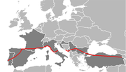
Sofia
Sofia is the capital and largest city of Bulgaria and the 12th largest city in the European Union with a population of 1.27 million people. It is located in western Bulgaria, at the foot of Mount Vitosha and approximately at the centre of the Balkan Peninsula.Prehistoric settlements were excavated...
in Bulgaria, followed by E80 highways to Niš
Niš
Niš is the largest city of southern Serbia and third-largest city in Serbia . According to the data from 2011, the city of Niš has a population of 177,972 inhabitants, while the city municipality has a population of 257,867. The city covers an area of about 597 km2, including the urban area,...
, Pristina
Pristina
Pristina, also spelled Prishtina and Priština is the capital and largest city of Kosovo. It is the administrative centre of the homonymous municipality and district....
, Dubrovnik
Dubrovnik
Dubrovnik is a Croatian city on the Adriatic Sea coast, positioned at the terminal end of the Isthmus of Dubrovnik. It is one of the most prominent tourist destinations on the Adriatic, a seaport and the centre of Dubrovnik-Neretva county. Its total population is 42,641...
, Pescara
Pescara
Pescara is the capital city of the Province of Pescara, in the Abruzzo region of Italy. As of January 1, 2007 it was the most populated city within Abruzzo at 123,059 residents, 400,000 with the surrounding metropolitan area...
, Rome
Rome
Rome is the capital of Italy and the country's largest and most populated city and comune, with over 2.7 million residents in . The city is located in the central-western portion of the Italian Peninsula, on the Tiber River within the Lazio region of Italy.Rome's history spans two and a half...
, Genoa
Genoa
Genoa |Ligurian]] Zena ; Latin and, archaically, English Genua) is a city and an important seaport in northern Italy, the capital of the Province of Genoa and of the region of Liguria....
, Nice
Nice
Nice is the fifth most populous city in France, after Paris, Marseille, Lyon and Toulouse, with a population of 348,721 within its administrative limits on a land area of . The urban area of Nice extends beyond the administrative city limits with a population of more than 955,000 on an area of...
, Toulouse
Toulouse
Toulouse is a city in the Haute-Garonne department in southwestern FranceIt lies on the banks of the River Garonne, 590 km away from Paris and half-way between the Atlantic Ocean and the Mediterranean Sea...
, Burgos
Burgos
Burgos is a city of northern Spain, historic capital of Castile. It is situated at the edge of the central plateau, with about 178,966 inhabitants in the city proper and another 20,000 in its suburbs. It is the capital of the province of Burgos, in the autonomous community of Castile and León...
, Valladolid
Valladolid
Valladolid is a historic city and municipality in north-central Spain, situated at the confluence of the Pisuerga and Esgueva rivers, and located within three wine-making regions: Ribera del Duero, Rueda and Cigales...
, Salamanca
Salamanca
Salamanca is a city in western Spain, in the community of Castile and León. Because it is known for its beautiful buildings and urban environment, the Old City was declared a UNESCO World Heritage Site in 1988. It is the most important university city in Spain and is known for its contributions to...
and finally Lisbon
Lisbon
Lisbon is the capital city and largest city of Portugal with a population of 545,245 within its administrative limits on a land area of . The urban area of Lisbon extends beyond the administrative city limits with a population of 3 million on an area of , making it the 9th most populous urban...
on the Atlantic Ocean.