

Kyushu Expressway
Encyclopedia
Expressways of Japan
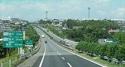
The expressways of Japan make up a large network of freeway-standard toll roads.- History :Following World War II, Japan's economic revival led to a massive increase in personal automobile use...
from Kitakyūshū (and the bridge to Honshū
Honshu
is the largest island of Japan. The nation's main island, it is south of Hokkaido across the Tsugaru Strait, north of Shikoku across the Inland Sea, and northeast of Kyushu across the Kanmon Strait...
) to west of Kagoshima
Kagoshima, Kagoshima
is the capital city of Kagoshima Prefecture at the southwestern tip of the Kyūshū island of Japan, and the largest city in the prefecture by some margin...
linking with the Higashi Kyushu Expressway and the Ibusuki Skyline. It runs through the prefectures of Fukuoka
Fukuoka Prefecture
is a prefecture of Japan located on Kyūshū Island. The capital is the city of Fukuoka.- History :Fukuoka Prefecture includes the former provinces of Chikugo, Chikuzen, and Buzen....
, the eastern half of the Saga
Saga Prefecture
is located in the northwest part of the island of Kyūshū, Japan. It touches both the Sea of Japan and the Ariake Sea. The western part of the prefecture is a region famous for producing ceramics and porcelain, particularly the towns of Karatsu, Imari, and Arita...
, Kumamoto
Kumamoto Prefecture
is a prefecture of Japan located on Kyushu Island. The capital is the city of Kumamoto.- History :Historically the area was called Higo Province; and the province was renamed Kumamoto during the Meiji Restoration. The creation of prefectures was part of the abolition of the feudal system...
, Miyazaki
Miyazaki Prefecture
is a prefecture of Japan located on the island of Kyushu. The capital is the city of Miyazaki.- History :Historically, after the Meiji Restoration, Hyūga Province was renamed Miyazaki Prefecture....
(Ebino only) and the Kagoshima
Kagoshima Prefecture
is a prefecture of Japan located on the island of Kyushu. The capital is the city of Kagoshima.- Geography :Kagoshima Prefecture is located at the southwest tip of Kyushu and includes a chain of islands stretching further to the southwest for a few hundred kilometers...
prefectures. The freeway runs entirely on the island of Kyūshū
Kyushu
is the third largest island of Japan and most southwesterly of its four main islands. Its alternate ancient names include , , and . The historical regional name is referred to Kyushu and its surrounding islands....
. The total length is 346.4 km. It does not cover Ōita
Oita, Oita
is the capital city of Ōita Prefecture located on the island of Kyushu, Japan.- Demographics and geography :Ōita is the most populous city in Ōita Prefecture...
or Nagasaki.
History
- June 30, 1971, a section from Ueki to Kumamoto was opened to traffic
- October 21, 1972, a section from Nankan to Ueki opened to traffic
- November 16, 1973, Tosu Interchange and Junction to Nankan was opened to traffic
- December 13, 1973, Kajiki Interchange to Satsuma-Yoshida was opened to traffic
- March 13, 1975, Koga Interchange to Tosu Junction was opened to traffic
- March 4, 1976, Ebuno Junction with the Miyazaki Expressway to Ebuno Interchange was opened.
- November 26, 1976, The section was opened to traffic from Kumatoto to Mifune Interchanges
- November 29, 1976, a section from Mizobe Kagoshimna Airport to Kajiki Interchanges was opened
- July 21, 1977, a section from Wakamiya to Koga was open to traffic
- November 15, 1977, a section from Satsuma-Yoshida to Kagoshima-Kita Interchanges was opened
- December 15, 1978, a section from Mifune to Matsubase Interchanges was opened
- March 8, 1979, a section from Wakamiya to Yahata Interchanges was opened
- March 12, 1980, a section from Matsubase to Yatsushiro Interchanges was opened
- March 22, 1980 a section from Kurino to Mizobe-Kagoshima Airport was opened
- October 1, 1981, a section from Ebuno Junction to Kurino Interchange opened made that section ran from Ebuno to Kagoshima-Kita interchanges that time
- March 27, 1984, a section from Moji to Kokura-Higashi was opened which made access to the bridge with HonshūHonshuis the largest island of Japan. The nation's main island, it is south of Hokkaido across the Tsugaru Strait, north of Shikoku across the Inland Sea, and northeast of Kyushu across the Kanmon Strait...
- March 28, 1985, the Tosu Junction in the west was opened.
- February 5, 1987, the Tosu Junction in the east was opened.
- March 29, 1988, a section from Kagoshima-Kita to Kagoshima was opened with an interchange with the expressway.
- March 31, 1988, a section from Kokura-Higashi to Yahata was opened to traffic
- October 19, 1988, a section in the Kagoshima Interchange with the Minami Kyushu Expressway was opened
- December 7, 1989, a section from Yatsushiro to Hitoyoshi was opened to traffic
- March 25, 1992, a section in the Kajiki Interchange with the road was opened
- March 31, 1993, the Shin-Moji Interchange was opened
- July 27, 1995, a section from Hitoyoshi to Ebuno was opened to traffic which made the Kyushu Expressway from Moji to Kagoshima fully accessible with no gaps.
- April 20, 1998, the Yatsushiro Junction was opened to traffic with another freeway
- December 19, 2001, Kajiki Junction was opened to traffic
- December 12, 2004, the tunnel from Hitoyoshi to Ebino Interchanges which made Kyushu Expressway with four lanes now being connected with no gaps
- February 26, 2006, Kitakyushu Junction was opened to traffic with another freeway
- March 29, 2009, the Miyama-Yanagawa Interchange was opened
- February 19, 2011, the Kurate Interchange was opened
List of interchanges and features
- IC - interchangeInterchange (road)In the field of road transport, an interchange is a road junction that typically uses grade separation, and one or more ramps, to permit traffic on at least one highway to pass through the junction without directly crossing any other traffic stream. It differs from a standard intersection, at which...
, SIC - smart interchange, JCT - junction, SA - service area, PA - parking area, BS - bus stopBus stopA bus stop is a designated place where buses stop for passengers to board or leave a bus. These are normally positioned on the highway and are distinct from off-highway facilities such as bus stations. The construction of bus stops tends to reflect the level of usage...
, TN - tunnelTunnelA tunnel is an underground passageway, completely enclosed except for openings for egress, commonly at each end.A tunnel may be for foot or vehicular road traffic, for rail traffic, or for a canal. Some tunnels are aqueducts to supply water for consumption or for hydroelectric stations or are sewers...
, TB - toll gate, BR - bridgeBridgeA bridge is a structure built to span physical obstacles such as a body of water, valley, or road, for the purpose of providing passage over the obstacle... - Bus stops labeled "○" are currently in use; those marked "◆" are closed.
| Number | Name | Connections | Distance from Moji Moji-ku, Kitakyushu is a ward of Kitakyūshū, Fukuoka Prefecture, Japan. It is the former city of Moji which was one of five cities merged to create Kitakyūshū in 1963. It faces the city of Shimonoseki across the Kanmon Straits between Honshū and Kyūshū.... (Km) |
Bus Stop | Notes | Location | |
|---|---|---|---|---|---|---|---|
| Through to Kanmon Bridge | |||||||
| 1 | Moji IC | Kitakyushu Expressway 4 | 0.0 | Fukuoka Fukuoka Prefecture is a prefecture of Japan located on Kyūshū Island. The capital is the city of Fukuoka.- History :Fukuoka Prefecture includes the former provinces of Chikugo, Chikuzen, and Buzen.... |
Kitakyūshū Kitakyushu, Fukuoka is a city located in Fukuoka Prefecture, Kyūshū, Japan. It is midway between Tokyo and Shanghai.- Demographics :Kitakyūshū has a population of just under one million... |
||
| - | Hata BS | - | 4.0 | ◆ | |||
| 1-1 | Shin-Moji Interchange | 4.4 | Only exit for Fukuoka | ||||
| - | Kishi PA | - | 6.2 | ||||
| - | Kuzuhara BS | - | 11.1 | ◆ | |||
| 2 | Kokura-Higashi IC | Kitakyushu Expressway 1 Route 10 Route 10 (Japan) thumb|240px|right|Route 10, Oita, Oitathumb|240px|right|Route 10, Fukuoka, KandaNational Route 10 is a Japanese highway on the island of Kyūshū. It originates at the intersection with Route 2 in Kitakyushu, Fukuoka and passes through the prefectural capitals of Ōita and Miyazaki, terminating at the... (Sone Bypass) |
13.3 | ||||
| 2-1 | Kitakyushu JCT | Higashi-Kyushu Expressway | 16.4 | ||||
| 3 | Kokura-Minami IC | Route 322 Route 322 (Japan) National Route 322 is a national highway of Japan connecting Kokura Kita-ku, Kitakyūshū and Kurume, Fukuoka in Japan, with a total length of 87.9 km .... |
20.2 | ○ | |||
| 4 | Yahata IC | Kitakyushu Expressway 4 Route 200 Route 200 (Japan) National Route 200 is a national highway of Japan connecting Yahata Nishi-ku, Kitakyūshū and Chikushino, Fukuoka in Japan, with a total length of 60.4 km .... (Nogata Bypass) |
31.3 | ○ | |||
| - | Nogata PA | - | 34.9 | ○ | Only accessible for Hiroshima | Nogata Nogata, Fukuoka is a city located in Fukuoka prefecture, Japan, on the island of Kyushu in southern Japan. Located near Kitakyūshū and Iizuka, Nōgata is in the center of the Chikuhō region of Fukuoka.... |
|
| 4-1 | Kurate IC | 36.1 | Kurate Kurate, Fukuoka is a town located in Kurate District, Fukuoka, Japan.As of 2003, the town has an estimated population of 18,641 and a density of 523.92 persons per km². The total area is 35.58 km².-External links:*... |
||||
| - | Kurate PA | - | 36.3 | Only accessible for Fukuoka | |||
| - | Miyata SIC | Miyawaka Miyawaka, Fukuoka is a city located in Fukuoka, Japan. The city was founded on February 11, 2006, from the merger of the towns of Miyata and Wakamiya, both from Kurate District.... |
|||||
| 5 | Wakamiya IC | 45.2 | ○ | ||||
| - | Koga SA | - | 54.5 | Koga Koga, Fukuoka is a city located in Fukuoka Prefecture, Japan. It is north east of Fukuoka city.As of 2009, the city has an estimated population of 58,250. The population density is about 1,383 persons per km². The total area is 42.11 km².... |
|||
| 6 | Koga IC | Route 3 Route 3 (Japan) National Route 3 is a major highway on the island of Kyūshū in Japan. It connects the prefectural capital cities of Kagoshima National Route 3 is a major highway on the island of Kyūshū in Japan. It connects the prefectural capital cities of Kagoshima National Route 3 is a major highway on the... (Kashii Bypass) |
57.7 | ||||
| - | Aoyagi BS | - | 58.5 | ○ | |||
| - | Tachibanayama BS | - | 62.7 | ○ | Shingu Shingu, Fukuoka is a town located in Kasuya District, Fukuoka, Japan, between Koga and Higashi-ku, Fukuoka City.As of 2003, the town has an estimated population of 22,914 and a density of 1,211.74 persons per km². The total area is 18.91 km². A JR station opened in March 2010.... |
||
| Hisayama Hisayama, Fukuoka is a town located in Kasuya District, Fukuoka, Japan.As of 2003, the town has an estimated population of 7,692 and a density of 205.50 persons per km². The total area is 37.43 km². One of the few Costco in Japan is located here.-External links:*... |
|||||||
| 7 | Fukuoka IC | Fukuoka Expressway 4 Route 201 Route 201 (Japan) National Route 201 is a national highway of Japan connecting Higashi-ku, Fukuoka and Kanda, Fukuoka in Japan, with a total length of 64.5 km .... |
68.5 | ○ | Fukuoka Fukuoka, Fukuoka is the capital city of Fukuoka Prefecture and is situated on the northern shore of the island of Kyushu in Japan.Voted number 14 in a 2010 poll of the World's Most Livable Cities, Fukuoka is praised for its green spaces in a metropolitan setting. It is the most populous city in Kyushu, followed by... |
||
| 7-1 | Sue PA/SIC | 73.6 | ○ | Sue Sue, Fukuoka is a town located in Kasuya District, Fukuoka, Japan.As of 2003, the town had an estimated population of 25,343 and a density of 1,551.93 persons per km². The total area is 16.33 km².-External links:*... |
|||
| - | Umi BS | - | 75.5 | ○ | Umi Umi, Fukuoka is a town located in Kasuya District, Fukuoka, Japan.As of 2003, the town has an estimated population of 38,545 and a density of 1,275.48 persons per km². The total area is 30.22 km².... |
||
| 8 | Dazaifu IC | Fukuoka Expressway 2 Route 3(Fukuoka-Minami Bypass) |
80.2 | ○ | Dazaifu Dazaifu, Fukuoka is a city located in Fukuoka Prefecture, Japan. Nearby cities include Ōnojō and Chikushino. Although mostly urban, it does have arable land used for paddy fields and market gardening.... |
||
| - | Chikushino BS | - | 85.0 | ○ | Chikushino Chikushino, Fukuoka is a city located in Fukuoka, Japan.Bordering on Dazaifu, Chikushino is essentially a southern suburb of Fukuoka City. As of 2010, the city has an estimated population of 100,397. The total area is 87.78 km². The Tenjin Ōmuta Line runs through Chikushino at Murasaki Station and Asakuragaidō... |
||
| 8-1 | Chikushino IC | 87.1 | |||||
| - | Kiyama PA | - | 91.0 | ○ | Saga Saga Prefecture is located in the northwest part of the island of Kyūshū, Japan. It touches both the Sea of Japan and the Ariake Sea. The western part of the prefecture is a region famous for producing ceramics and porcelain, particularly the towns of Karatsu, Imari, and Arita... |
Kiyama Kiyama, Saga is a town located in Miyaki District, Saga Prefecture, Japan on the island of Kyūshū. It can be considered part of an economic sphere with nearby cities Tosu in Saga Prefecture and Ogōri and Kurume in Fukuoka Prefecture... |
|
| 9 | Tosu JCT/IC | Nagasaki Expressway Nagasaki Expressway ' is one of the Expressways of Japan from Tosu to Nagasaki. It runs through the prefecture of Saga, and the southern half of the Nagasaki prefecture... Ōita Expressway Route 3 Route 34 |
96.2 | Tosu Tosu, Saga is a city located in the east part of Saga Prefecture on the island of Kyūshū, Japan.-Overview:Tosu is one of the major transportation hubs of Kyūshū. Its main train station is Tosu Station which connects the Nagasaki Main Line and the Kagoshima Main Line. There is also a junction connecting the... |
|||
| - | Miyanojin BS | - | 102.6 | ○ | Fukuoka | Kurume Kurume, Fukuoka is a city located in Fukuoka prefecture, Japan.The city has an estimated population of 303,277 and a population density of 1,319.51 persons per km²... |
|
| 10 | Kurume IC | Route 322 | 105.6 | ○ | |||
| 10-1 | Hirokawa IC/SA | 113.6 | ○ | Hirokawa Hirokawa, Fukuoka is a town located in Yame District, Fukuoka, Japan.As of April 1, 2010, the town has an estimated population of 20,230 and a density of 534 persons per km². The total area is 37.91 km².-External links:*... |
|||
| 11 | Yame IC | Route 442 Route 442 (Japan) National Route 442 is a national highway of Japan connecting Ōita, Ōita and Ōkawa, Fukuoka in Japan, with a total length of 162.2 km .... |
118.6 | ○ | Yame Yame, Fukuoka is a city located in Fukuoka, Japan.As of 2003, the city has an estimated population of 39,372 and the density of 1,000.81 persons per km². The total area is 39.34 km².The city was founded on April 1, 1954.... |
||
| Chikugo Chikugo, Fukuoka is a city located in Fukuoka prefecture, Japan.As of May 31, 2011, the city has an estimated population of 48,808 with 17,322 households and a population density of 1,166.26 persons per km². The total area is 41.85 km².The city was founded on April 1, 1954.... |
|||||||
| - | Setaka BS | - | 122.5 | ○ | Miyama Miyama, Fukuoka is a city located in Fukuoka Prefecture, Japan. The city was founded on January 29, 2007, from the merger of the town of Takata, from Miike District, and the towns of Setaka and Yamakawa, both from Yamato District.... |
||
| 11-1 | Miyama-Yanagawa IC | 125.5 | - | ||||
| - | Yamakawa PA | - | 128.2 | ○ | |||
| 12 | Nankan IC | 135.2 | Kumamoto Kumamoto Prefecture is a prefecture of Japan located on Kyushu Island. The capital is the city of Kumamoto.- History :Historically the area was called Higo Province; and the province was renamed Kumamoto during the Meiji Restoration. The creation of prefectures was part of the abolition of the feudal system... |
Nankan Nankan, Kumamoto is a town in Tamana District, Kumamoto, Japan.As of 2003, the town has an estimated population of 11,553 and a density of 167.53 persons per km². The total area is 68.96 km².A main crops are rice and bamboo.-External links:*... |
|||
| - | Kobaru BS | - | 138.9 | ○ | |||
| - | Tamana PA | - | 142.9 | ||||
| 13 | Kikusui IC | 146.8 | ○ | Nagomi Nagomi, Kumamoto is a town located in Tamana District, Kumamoto Prefecture, Japan.The town was formed on March 1, 2006 from the merger of the towns of Kikusui and Mikawa, both from Tamana District.... |
|||
| - | Kaou BS | - | 153.7 | ○ | Yamaga Yamaga, Kumamoto is a city located in Kumamoto, Japan.On January 15, 2005 Yamaga absorbed the towns of Kahoku, Kamoto, Kaō and Kikuka, all from Kamoto District, into the new expanded city of Yamaga.... |
||
| 14 | Ueki IC | Route 3 | 157.5 | ○ | Kumamoto Kumamoto, Kumamoto is the capital city of Kumamoto Prefecture on the island of Kyushu, Japan. Greater Kumamoto has a population of 1,460,000, as of the 2000 census... |
||
| - | Kita-Kumamoto SA | - | 162.3 | ||||
| - | Nishi-Kōshi BS | - | 165.8 | ○ | Kōshi Koshi, Kumamoto is a city located in Kumamoto Prefecture, Japan.Formed by the amalgamation of the towns of Kōshi and Nishigōshi on February 27, 2006, the city has an estimated population of 52,500 and a density of 987.39 persons per km². The total area is 53.17 km². It was the 14th "Great Heisei Merger" in... |
||
| - | Musashigaoka BS | - | 169.1 | ○ | Kumamoto | ||
| 15 | Kumamoto IC | Route 57(Kumamoto-Higashi Bypass) | 171.4 | ||||
| - | Takuma PA | - | 174.5 | ||||
| 15-1 | Mashiki-Kumamoto Airport IC | 176.6 | Mashiki Mashiki, Kumamoto is a town located in Kamimashiki District, Kumamoto, Japan.As of 2003, the town has an estimated population of 32,600 and a density of 496.42 persons per km². The total area is 65.67 km².Kumamoto Airport is located in Mashiki.-External links:*... |
||||
| - | Mashiki BS | - | 177.5 | ○ | |||
| - | Kashima JCT | Kyushu Odan Expressway(Future) | 180.9 | Mifune Mifune, Kumamoto is a town located in Kamimashiki District, Kumamoto, Japan.As of 2003, the town has an estimated population of 18,282 and a density of 184.67 persons per km². The total area is 99.00 km².-External links:*... |
|||
| 16 | Mifune IC | Route 445 Route 445 (Japan) National Route 445 is a national highway of Japan connecting Kumamoto, Kumamoto and Hitoyoshi, Kumamoto in Japan, with a total length of 136.1 km .... |
183.3 | ○ | |||
| - | Midorikawa PA | - | 186.9 | Kumamoto | |||
| Kōsa Kosa, Kumamoto is a town located in Kamimashiki District, Kumamoto, Japan.As of 2003, the town has an estimated population of 11,720 and a density of 202.52 persons per km². The total area is 57.87 km².-External links:*... |
|||||||
| - | Jōnan BS | - | 189.1 | ○ | Kumamoto | ||
| 17 | Matsubase IC | Route 218 Route 218 (Japan) National Route 218 is a national highway of Japan connecting Kumamoto, Kumamoto and Nobeoka, Miyazaki in Japan, with a total length of 145.9 km .... |
195.3 | ○ | Uki Uki, Kumamoto is a city located in Kumamoto Prefecture, Japan.The city was founded on January 15, 2005, as a result of the merger between the towns of Misumi and Shiranuhi, both from Uto District, and the towns of Matsubase, Ogawa and Toyono, all from Shimomashiki District.... |
||
| - | Ogawa BS/SIC | - | 204.0 | ○ | |||
| - | Miyahara SA | - | 209.0 | ○ | Hikawa Hikawa, Kumamoto is a town located in Yatsushiro District, Kumamoto, Japan. The town was formed on October 1, 2005 from the merger of the towns of Miyahara and Ryūhoku.... |
||
| 18 | Yatsushiro IC | Route 3 | 213.7 | ○ | Yatsushiro Yatsushiro, Kumamoto is a city located in Kumamoto, Japan.On August 1, 2005, the city merged with the municipalities of Izumi, Kagami, Sakamoto, Senchō and Tōyō to form the new expanded city of Yashushiro.... |
||
| 18-1 | Yatsushiro JCT | Minami-Kyūshū Expressway Minami-Kyūshū Expressway The starts from Yatsushiro, Kumamoto, and it is a highway of about 140km planned extension to reach Kagoshima, Kagoshima via Minamata, Izumi, Akune, Satsumasendai of the high standard highway... |
214.8 | Only accessible for Fukuoka | |||
| - | Sakamoto PA | - | 222.4 | ○ | |||
| - | Ayugaeri BS | - | 230.3 | ○ | |||
| - | Higo TN | - | Length 6,300m | ||||
| Yamae Yamae, Kumamoto is a village located in Kuma District, Kumamoto, Japan.In 2003 the village had an estimated population of 3,996 and a population density of 32.97 persons per km². The total area is 121.2 km².-External links:*... |
|||||||
| - | Koduru BS | - | 242.5 | ○ | |||
| - | Yamae SA | - | 248.5 | ○ | |||
| 19 | Hitoyoshi IC | 252.2 | ○ | ||||
| Hitoyoshi Hitoyoshi, Kumamoto is a city located in Kumamoto, Japan.As of 2008, the city has an estimated population of 36,297 and the density of 172 persons per km². The total area is 210.55 km².The city was founded on February 11, 1942.... |
|||||||
| - | Hitoyoshi-Minami BS | - | 256.6 | ○ | |||
| - | Kakutō TN | - | Length 6,300m | ||||
| Miyazaki Miyazaki Prefecture is a prefecture of Japan located on the island of Kyushu. The capital is the city of Miyazaki.- History :Historically, after the Meiji Restoration, Hyūga Province was renamed Miyazaki Prefecture.... |
Ebino Ebino, Miyazaki is a city located in Miyazaki Prefecture, Japan. Ebino shares borders with Kagoshima Prefecture, Kumamoto Prefecture and Kobayashi, Miyazaki.-History:The town of Ebino was created through the administrative merging of the towns of Masaki, Kakutō, and Īno in 1966... |
||||||
| - | Ebino PA | - | 272.0 | ||||
| 20 | Ebino IC | Route 268 Route 268 (Japan) National Route 268 is a national highway of Japan connecting Minamata, Kumamoto and Miyazaki, Miyazaki in Japan, with a total length of 114.3 km .... |
274.5 | ○ | |||
| 21 | Ebino JCT | Miyazaki Expressway Miyazaki Expressway ' is one of the Expressways of Japan from Ebino to Miyazaki linking with the Higashi Kyushu Expressway. It runs through the southern half of the Miyazaki prefecture... |
276.5 | ||||
| - | Yoshimatsu PA | - | 281.9 | ○ | Kagoshima Kagoshima Prefecture is a prefecture of Japan located on the island of Kyushu. The capital is the city of Kagoshima.- Geography :Kagoshima Prefecture is located at the southwest tip of Kyushu and includes a chain of islands stretching further to the southwest for a few hundred kilometers... |
Yūsui Yusui, Kagoshima is a town located in Aira District, Kagoshima, Japan.As of September 1, 2011, the town has an estimated population of 11,420 and the density of 79.1 persons per km²... |
|
| 22 | Kurino IC | 290.3 | |||||
| 23 | Yokogawa IC | 296.3 | Kirishima | ||||
| - | Mizobe PA | - | 303.0 | ||||
| - | Kagoshima Airport-Minami BS | - | 308.8 | ○ | |||
| 24 | Mizobe-Kagoshima Airport IC | Route 504 Route 504 (Japan) National Route 504 is a national highway of Japan connecting between Kanoya, Kagoshima and Izumi, Kagoshima in Japan, with total length has 145.1 km .... |
310.1 | ||||
| 25-1 25 |
Kajiki JCT Kajiki IC |
Higashi-Kyushu Expressway Route 10(Kajiki Bypass) |
317.8 | Aira | |||
| - | Chōsa BS | - | 322.3 | ○ | |||
| - | Sakurajima SA | - | 323.8 | ||||
| 26 | Aira IC | 326.5 | |||||
| - | Honjō BS | - | 330.7 | ◆ | Kagoshima Kagoshima, Kagoshima is the capital city of Kagoshima Prefecture at the southwestern tip of the Kyūshū island of Japan, and the largest city in the prefecture by some margin... |
||
| 27 | Satsuma-Yoshida IC | 335.1 | |||||
| - | Kagoshima TB | - | 337.0 | Toll Barrier | |||
| 28 | Kagoshima-KitaIC/Ishiki BS | Route 3 | 341.7 | ○ | |||
| 29 | Kagoshima IC | Minami-Kyushu Expressway Route 3(Kagoshima Bypass) |
346.4 | ||||
| 30 | Kingo IC | Mikichi-Kyushu Expressway Route 3 |
352.6 | ||||
| 31 | Linkyo IC | Mikichi-Kyushu Expressway Route 3 |
358.3 | ||||
| Through to Ibusuki Skyline | |||||||
Lanes
- 6-lane, Dazaifu to Kurume Interchanges
- 4-lane, Moji to Dazaifu Interchange and from Kurume to Kagoshima Interchanges
External links
- NEXCO West-Japan Official website(in Japanese)