
Volcanism in New Zealand
Encyclopedia
The volcanism of New Zealand has been responsible for many of the country's geographical features, especially in the North Island
North Island
The North Island is one of the two main islands of New Zealand, separated from the much less populous South Island by Cook Strait. The island is in area, making it the world's 14th-largest island...
and the country's outlying islands
New Zealand Outlying Islands
The New Zealand outlying islands comprise nine island groups, located in the subtropics and subantarctic, which are part of New Zealand but lie outside of the New Zealand continental shelf. Although considered as integral parts of New Zealand, seven of the nine island groups are not part of any...
. It has also claimed many lives.
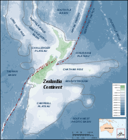
While the land's volcanic history dates back to before the Zealandia
Zealandia (continent)
Zealandia , also known as Tasmantis or the New Zealand continent, is a nearly submerged continental fragment that sank after breaking away from Australia 60–85 million years ago, having separated from Antarctica between 85 and 130 million years ago...
microcontinent rift
Rift
In geology, a rift or chasm is a place where the Earth's crust and lithosphere are being pulled apart and is an example of extensional tectonics....
ed away from Gondwana
Gondwana
In paleogeography, Gondwana , originally Gondwanaland, was the southernmost of two supercontinents that later became parts of the Pangaea supercontinent. It existed from approximately 510 to 180 million years ago . Gondwana is believed to have sutured between ca. 570 and 510 Mya,...
60-130 million years ago, activity continues today with minor eruptions occurring every few years. This recent activity is primarily due to the country's position on the boundary between the Indo-Australian
Indo-Australian Plate
The Indo-Australian Plate is a major tectonic plate that includes the continent of Australia and surrounding ocean, and extends northwest to include the Indian subcontinent and adjacent waters...
and Pacific Plate
Pacific Plate
The Pacific Plate is an oceanic tectonic plate that lies beneath the Pacific Ocean. At 103 million square kilometres, it is the largest tectonic plate....
s, a part of the Pacific Ring of Fire
Pacific Ring of Fire
The Pacific Ring of Fire is an area where large numbers of earthquakes and volcanic eruptions occur in the basin of the Pacific Ocean. In a horseshoe shape, it is associated with a nearly continuous series of oceanic trenches, volcanic arcs, and volcanic belts and/or plate movements...
, and particularly the subduction
Subduction
In geology, subduction is the process that takes place at convergent boundaries by which one tectonic plate moves under another tectonic plate, sinking into the Earth's mantle, as the plates converge. These 3D regions of mantle downwellings are known as "Subduction Zones"...
of the Pacific Plate under the Indo-Australian Plate.
New Zealand
New Zealand
New Zealand is an island country in the south-western Pacific Ocean comprising two main landmasses and numerous smaller islands. The country is situated some east of Australia across the Tasman Sea, and roughly south of the Pacific island nations of New Caledonia, Fiji, and Tonga...
's rocks record examples of almost every kind of volcanism
Volcanism
Volcanism is the phenomenon connected with volcanoes and volcanic activity. It includes all phenomena resulting from and causing magma within the crust or mantle of a planet to rise through the crust and form volcanic rocks on the surface....
observed on Earth, including some of the world's largest eruptions in geologically recent times.
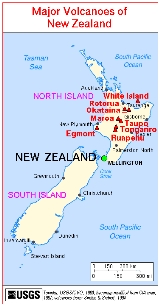
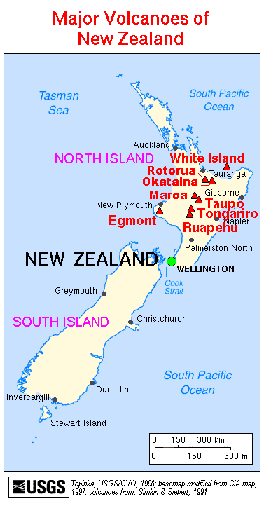
Major eruptions
Supervolcano
A supervolcano is a volcano capable of producing a volcanic eruption with an ejecta volume greater than 1,000 cubic kilometers . This is thousands of times larger than most historic volcanic eruptions. Supervolcanoes can occur when magma in the Earth rises into the crust from a hotspot but is...
size. These include eruptions from Macauley Island
Macauley Island
Macauley Island is a volcanic island in New Zealand's Kermadec Islands, approximately halfway between New Zealand's North Island and Tonga in the southwest Pacific Ocean....
and the Taupo, Whakamaru, Mangakino, Reporoa
Reporoa caldera
The Reporoa caldera is a 10 km by 15 km caldera in New Zealand's Taupo Volcanic Zone. It formed some 230,000 years ago, in a large eruption that deposited the approximately 100 km3 Kaingaroa Ignimbrites. It contains three rhyolitic lava domes and the active Reporoa geothermal field...
, Rotorua
Rotorua Caldera
The Rotorua Caldera is one of several large volcanoes located in the Taupo Volcanic Zone on the North Island of New Zealand. Its last major eruption was about 240,000 years ago. At this time, the Mamaku ignimbrite, covering about 4000 square km, was deposited. After the eruption, the magma...
, and Haroharo caldera
Caldera
A caldera is a cauldron-like volcanic feature usually formed by the collapse of land following a volcanic eruption, such as the one at Yellowstone National Park in the US. They are sometimes confused with volcanic craters...
s.
Two relatively recent eruptions from the Taupo volcano are perhaps the best known. Its Oruanui eruption
Oruanui eruption
The Oruanui eruption of New Zealand's Taupo Volcano was the world's largest known eruption in the past 70,000 years, with a Volcanic Explosivity Index of 8...
was the world's largest known eruption in the past 70,000 years, with a Volcanic Explosivity Index
Volcanic Explosivity Index
The Volcanic Explosivity Index was devised by Chris Newhall of the U.S. Geological Survey and Stephen Self at the University of Hawaii in 1982 to provide a relative measure of the explosiveness of volcanic eruptions....
(VEI) of 8. It occurred around 26,500 years ago and deposited approximately 1,200 km³ of material. Tephra
Tephra
200px|thumb|right|Tephra horizons in south-central [[Iceland]]. The thick and light coloured layer at center of the photo is [[rhyolitic]] tephra from [[Hekla]]....
from the eruption covered much of the central North Island with ignimbrite
Ignimbrite
An ignimbrite is the deposit of a pyroclastic density current, or pyroclastic flow, a hot suspension of particles and gases that flows rapidly from a volcano, driven by a greater density than the surrounding atmosphere....
up to 200 metres (650 feet) deep, and most of New Zealand was affected by ash fall, with even an 18 cm (7 inch) ash layer left on the Chatham Islands
Chatham Islands
The Chatham Islands are an archipelago and New Zealand territory in the Pacific Ocean consisting of about ten islands within a radius, the largest of which are Chatham Island and Pitt Island. Their name in the indigenous language, Moriori, means Misty Sun...
, 1000 km (621.4 mi) away. Later erosion and sedimentation had long-lasting effects on the landscape, causing the Waikato River
Waikato River
The Waikato River is the longest river in New Zealand. In the North Island, it runs for 425 kilometres from the eastern slopes of Mount Ruapehu, joining the Tongariro River system and emptying into Lake Taupo, New Zealand's largest lake. It drains Taupo at the lake's northeastern edge, creates the...
to shift from the Hauraki Plains
Hauraki Plains
The Hauraki Plains are a geographical feature and non-administrative area located in the northern North Island of New Zealand, at the lower end of the Thames Valley...
to its current course through the Waikato to the Tasman Sea
Tasman Sea
The Tasman Sea is the large body of water between Australia and New Zealand, approximately across. It extends 2,800 km from north to south. It is a south-western segment of the South Pacific Ocean. The sea was named after the Dutch explorer Abel Janszoon Tasman, the first recorded European...
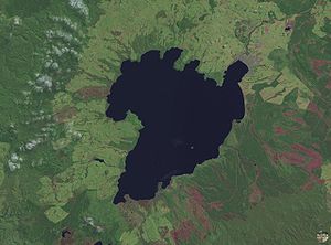
. New Zealand's largest lake, Lake Taupo
Lake Taupo
Lake Taupo is a lake situated in the North Island of New Zealand. With a surface area of , it is the largest lake by surface area in New Zealand, and the second largest freshwater lake by surface area in geopolitical Oceania after Lake Murray ....
, fills the caldera
Caldera
A caldera is a cauldron-like volcanic feature usually formed by the collapse of land following a volcanic eruption, such as the one at Yellowstone National Park in the US. They are sometimes confused with volcanic craters...
formed in this eruption.
Taupo's most recent major eruption, the Taupo or Hatepe eruption
Hatepe eruption
The Hatepe eruption around the year 180 CE was Lake Taupo's most recent major eruption, and New Zealand's largest eruption during the last 20,000 years. It ejected some of material , of which was ejected in the space of a few minutes...
, took place around 180 CE, and is New Zealand's largest eruption since Oruanui. It ejected some 120 km³ of material (rating 7 on the VEI scale), with around 30 km³ ejected in just a few minutes. It is believed that the eruption column was 50 kilometres (31.1 mi) high, twice as high as the eruption column from Mount St. Helens
Mount St. Helens
Mount St. Helens is an active stratovolcano located in Skamania County, Washington, in the Pacific Northwest region of the United States. It is south of Seattle, Washington and northeast of Portland, Oregon. Mount St. Helens takes its English name from the British diplomat Lord St Helens, a...
in 1980. This makes it one of the most violent eruptions in the last 5000 years (alongside the Tianchi eruption of Baekdu
Baekdu Mountain
Baekdu Mountain, also known in China as Changbai Mountain and Baitou Mountain , is a volcanic mountain on the border between North Korea and China, located at...
at around 1000 and the 1815 eruption of Tambora
Mount Tambora
Mount Tambora is an active stratovolcano, also known as a composite volcano, on the island of Sumbawa, Indonesia. Sumbawa is flanked both to the north and south by oceanic crust, and Tambora was formed by the active subduction zone beneath it. This raised Mount Tambora as high as , making it...
). The resulting ash turned the sky red over Rome
Rome
Rome is the capital of Italy and the country's largest and most populated city and comune, with over 2.7 million residents in . The city is located in the central-western portion of the Italian Peninsula, on the Tiber River within the Lazio region of Italy.Rome's history spans two and a half...
and China
China
Chinese civilization may refer to:* China for more general discussion of the country.* Chinese culture* Greater China, the transnational community of ethnic Chinese.* History of China* Sinosphere, the area historically affected by Chinese culture...
.
Mount Tarawera
Mount Tarawera
Mount Tarawera is the volcano responsible for New Zealand's largest historic eruption. Located 24 kilometres southeast of Rotorua in the North Island, it consists of a series of rhyolitic lava domes that were fissured down the middle by an explosive basaltic eruption in 1886, which killed over...
's eruption around 1310 CE, while not nearly as large, was still substantial, producing 2.5 km³ of lava
Lava
Lava refers both to molten rock expelled by a volcano during an eruption and the resulting rock after solidification and cooling. This molten rock is formed in the interior of some planets, including Earth, and some of their satellites. When first erupted from a volcanic vent, lava is a liquid at...
and 5 km³ of tephra (VEI 5). Because its deposits, stretching from Gisborne
Gisborne, New Zealand
-Economy:The harbour was host to many ships in the past and had developed as a river port to provide a more secure location for shipping compared with the open roadstead of Poverty Bay which can be exposed to southerly swells. A meat works was sited beside the harbour and meat and wool was shipped...
to the Bay of Islands
Bay of Islands
The Bay of Islands is an area in the Northland Region of the North Island of New Zealand. Located 60 km north-west of Whangarei, it is close to the northern tip of the country....
, were emplaced around the time that Māori permanently settled New Zealand, they have provided a useful archeological marker. Tarawera erupted again on June 10, 1886, spewing ash and debris over 16000 km² (6,177.6 sq mi), destroying the Pink and White Terraces
Pink and White Terraces
The Pink and White Terraces, also called Otukapuarangi or Te Tarata in Māori, were a natural wonder of New Zealand...
and three villages, including Te Wairoa
Te Wairoa
Te Wairoa, also known as The Buried Village is located close to the shore of Lake Tarawera in New Zealand's North Island. It was a Māori and European settlement where visitors would stay on their way to visit the Pink and White Terraces. The village was destroyed by the eruption of the volcano...
, and claiming the lives of perhaps 120 people. Approximately 2 km³ of tephra was erupted (VEI 5).
Hazards
As well as the direct effects of explosions, lavaLava
Lava refers both to molten rock expelled by a volcano during an eruption and the resulting rock after solidification and cooling. This molten rock is formed in the interior of some planets, including Earth, and some of their satellites. When first erupted from a volcanic vent, lava is a liquid at...
, and pyroclastic flow
Pyroclastic flow
A pyroclastic flow is a fast-moving current of superheated gas and rock , which reaches speeds moving away from a volcano of up to 700 km/h . The flows normally hug the ground and travel downhill, or spread laterally under gravity...
s, volcanoes pose various hazards to the New Zealand populace. These include tsunami
Tsunami
A tsunami is a series of water waves caused by the displacement of a large volume of a body of water, typically an ocean or a large lake...
s, breakout floods and lahar
Lahar
A lahar is a type of mudflow or debris flow composed of a slurry of pyroclastic material, rocky debris, and water. The material flows down from a volcano, typically along a river valley. The term is a shortened version of "berlahar" which originated in the Javanese language of...
s from volcanically dammed lakes, ashfall, and other far field effects.
Tangiwai disaster
The Tangiwai disaster on 24 December 1953 was the worst rail accident in New Zealand history. An 11-carriage overnight express from Wellington to Auckland fell into the Whangaehu River at Tangiwai, ten kilometres west of Waiouru. The bridge carrying the North Island Main Trunk Railway over the...
occurred on 24 December 1953 when the Tangiwai railway bridge across the Whangaehu River collapsed from a lahar
Lahar
A lahar is a type of mudflow or debris flow composed of a slurry of pyroclastic material, rocky debris, and water. The material flows down from a volcano, typically along a river valley. The term is a shortened version of "berlahar" which originated in the Javanese language of...
in full flood, just before an express train was about to cross it. The train could not stop in time, and 151 lives were lost. This was ultimately caused by Ruapehu's 1945 eruption, which had emptied the crater lake
Crater lake
A crater lake is a lake that forms in a volcanic crater or caldera, such as a maar; less commonly and with lower association to the term a lake may form in an impact crater caused by a meteorite. Sometimes lakes which form inside calderas are called caldera lakes, but often this distinction is not...
and dammed the outlet with tephra.
Effects can be widespread even for eruptions of only moderate size. Ash plumes from Ruapehu's 1996 eruption forced the closure of eleven airports, including Auckland International Airport
Auckland International Airport
Auckland Airport is the largest and busiest airport in New Zealand with over 13 million passengers a year, expected to more than double by 2025...
.
Insurance against volcanic damage (along with other natural disasters) is provided by the country's Earthquake Commission
Earthquake Commission
The Earthquake Commission provides primary natural disaster insurance to the owners of residential properties in New Zealand. The Government-owned Crown entity manages assets of $5.93 billion NZD...
.
Cultural references
The Māori had many myths and legends regarding the land's volcanic mountains. Perhaps the most well known regards the location of Taranaki, Tongariro and PihangaPihanga
Mount Pihanga is a 1325m volcanic peak in the North Island Volcanic Plateau, located to the north of Mount Tongariro, between Tongariro and Lake Taupo. Lake Rotoaira lies immediately to the west of Pihanga, and the smaller Lake Rotopounamu is at the north-west foot of the mountain. Mt...
as they stand today. It is said that the other two volcanoes competed for the love of the beautiful Pihanga, and Taranaki lost. Defeated, Taranaki moved to its present location near New Plymouth
New Plymouth
New Plymouth is the major city of the Taranaki Region on the west coast of the North Island of New Zealand. It is named after Plymouth, Devon, England, from where the first English settlers migrated....
.
Ngatoro-i-rangi
In Māori tradition, Ngātoro-i-rangi is the name of a tohunga prominent during the settling of Aotearoa by the Māori people, who came from the mythical homeland Hawaiki.-Rangiātea:...
, a tohunga (priest) who arrived from the ancestral Māori homeland, Hawaiki
Hawaiki
In Māori mythology, Hawaiki is the homeland of the Māori, the original home of the Māori, before they travelled across the sea to New Zealand...
, on the Arawa waka (canoe). Travelling inland and looking southward from Lake Taupō
Lake Taupo
Lake Taupo is a lake situated in the North Island of New Zealand. With a surface area of , it is the largest lake by surface area in New Zealand, and the second largest freshwater lake by surface area in geopolitical Oceania after Lake Murray ....
, he decided to climb the mountains he saw there. He reached and began to climb the first mountain along with his slave Ngāuruhoe, who had been travelling with him, and named the mountain Tongariro (the name literally means 'looking south'), whereupon the two were overcome by a blizzard carried by the cold south wind.
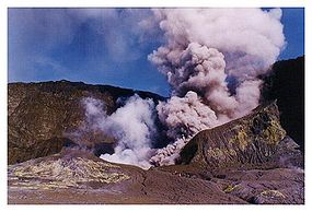
Near death, Ngātoro-i-rangi called back to his two sisters, Kuiwai and Haungaroa, who had also come from Hawaiki but remained upon Whakaari/White Island
Whakaari/White Island
Whakaari/White Island is an active andesite stratovolcano, situated from the east coast of the North Island of New Zealand, in the Bay of Plenty. The nearest mainland towns are Whakatane and Tauranga....
, to send him sacred fire which they had brought from Hawaiki. This they did, sending the fire in the form of two taniwha
Taniwha
In Māori mythology, taniwha are beings that live in deep pools in rivers, dark caves, or in the sea, especially in places with dangerous currents or deceptive breakers...
(powerful spirits) named Te Pupu and Te Haeata by a subterranean passage to the top of Tongariro. The tracks of these two taniwha formed the line of geothermal fire which extends from the Pacific Ocean
Pacific Ocean
The Pacific Ocean is the largest of the Earth's oceanic divisions. It extends from the Arctic in the north to the Southern Ocean in the south, bounded by Asia and Australia in the west, and the Americas in the east.At 165.2 million square kilometres in area, this largest division of the World...
and beneath the Taupo Volcanic Zone, and is seen in the many volcanoes and hot spring
Hot spring
A hot spring is a spring that is produced by the emergence of geothermally heated groundwater from the Earth's crust. There are geothermal hot springs in many locations all over the crust of the earth.-Definitions:...
s extending from Whakaari to Tokaanu and up to the Tongariro massif. The fire arrived just in time to save Ngātoro-i-rangi from freezing to death, but Ngāuruhoe was already dead by the time Ngātoro-i-rangi turned to give him the fire. For this reason the hole through which the fire ascended, the active cone of Tongariro, is now called Ngauruhoe.
Volcanic areas
There are remnants of volcanic activity throughout most of New Zealand, but there are several areas where this is more obvious, and some where activity is very much continuing. Eruptions have been confined to the Taupo Volcanic Zone and the Kermadec Arc since Taranaki's last activity in 1854.Kermadec Arc
The Kermadec IslandsKermadec Islands
The Kermadec Islands are a subtropical island arc in the South Pacific Ocean northeast of New Zealand's North Island, and a similar distance southwest of Tonga...
are an active volcanic island arc
Island arc
An island arc is a type of archipelago composed of a chain of volcanoes which alignment is arc-shaped, and which are situated parallel and close to a boundary between two converging tectonic plates....
stretching north-northeast from New Zealand's North Island towards Tonga. While only a few volcanoes in the arc are tall enough to form islands, it also includes about 30 sizeable submarine volcano
Submarine volcano
Submarine volcanoes are underwater fissures in the Earth's surface from which magma can erupt. They are estimated to account for 75% of annual magma output. The vast majority are located near areas of tectonic plate movement, known as ocean ridges...
es. The largest island, Raoul Island
Raoul Island
Anvil-shaped Raoul Island , the largest and northernmost of the main Kermadec Islands, , has been the source of vigorous volcanic activity during the past several thousand years that was dominated by dacitic explosive eruptions.The area of the island, including fringing islets and rocks...
, produced a large eruption around 2200 years ago. Its activity has continued intermittently since, with its latest eruption occurring in 2006.
Northland
The Northland region contains recently active two volcanic fieldVolcanic field
A volcanic field is an area of the Earth's crust that is prone to localized volcanic activity. They usually contain 10 to 100 volcanoes, such as cinder cones and are usually in clusters. Lava flows may also occur...
s around Whangarei
Whangarei
Whangarei, pronounced , is the northernmost city in New Zealand and the regional capital of Northland Region. Although commonly classified as a city, it is officially part of the Whangarei District, administered by the Whangarei District Council a local body created in 1989 to administer both the...
and the Bay of Islands
Bay of Islands
The Bay of Islands is an area in the Northland Region of the North Island of New Zealand. Located 60 km north-west of Whangarei, it is close to the northern tip of the country....
. (Kaikohe-Bay of Islands volcanic field
Kaikohe-Bay of Islands volcanic field
Kaikohe-Bay of Islands volcanic field is located in the Northland region of New Zealand, near Kaikohe. It contains around 12 small basaltic scoria cones, and a rhyolite dome, which erupted between 500,000 and 60,000 years ago.-List of volcanoes:...
). Their latest activity, around 1300–1800 years ago, created four scoria cones at Te Puke (near Paihia
Paihia
Paihia is the main tourist town in the Bay of Islands in the far north of the North Island of New Zealand. It is located close to the historic towns of Russell, and Kerikeri, 60 kilometres north of Whangarei. The origin of the name Paihia is obscure. One, possibily apocryphal, attribution is to...
).
Earlier, during the Miocene
Miocene
The Miocene is a geological epoch of the Neogene Period and extends from about . The Miocene was named by Sir Charles Lyell. Its name comes from the Greek words and and means "less recent" because it has 18% fewer modern sea invertebrates than the Pliocene. The Miocene follows the Oligocene...
, a mainly andesitic
Andesite
Andesite is an extrusive igneous, volcanic rock, of intermediate composition, with aphanitic to porphyritic texture. In a general sense, it is the intermediate type between basalt and dacite. The mineral assemblage is typically dominated by plagioclase plus pyroxene and/or hornblende. Magnetite,...
volcanic arc ran through Northland and neighbouring regions (including the Three Kings Ridge and northern Coromandel Peninsula), with western and eastern belts active between 25–15 million years ago and 23–11 million years ago respectively. Although this produced substantial volcanic edifices, including New Zealand's largest known stratovolcano
Stratovolcano
A stratovolcano, also known as a composite volcano, is a tall, conical volcano built up by many layers of hardened lava, tephra, pumice, and volcanic ash. Unlike shield volcanoes, stratovolcanoes are characterized by a steep profile and periodic, explosive eruptions...
, most of these have been eroded away, buried, or submerged, especially in the west, where a series of volcanoes buried offshore stretches south almost to New Plymouth
New Plymouth
New Plymouth is the major city of the Taranaki Region on the west coast of the North Island of New Zealand. It is named after Plymouth, Devon, England, from where the first English settlers migrated....
. Remnants are stlll exposed in many places, including Whangarei Heads
Whangarei Heads
Whangarei Heads is a locality and promontory on the northern side of the Whangarei Harbour in Northland, New Zealand. Whangarei is 29 km to the north west, and Ocean Beach is 8 km to the south east, with Taurikura between the two. Mount Manaia rises to 420 m to the east.Immediately to the...
, the Hen and Chickens Islands, around Whangaroa Harbour
Whangaroa Harbour
Whangaroa Harbour is an inlet on the northern coast of Northland, New Zealand. Whangaroa Bay and the Pacific Ocean are to the north. The small settlements of Totara North and Saies are on the west side of the harbour, Waitaruke on the south side, and Whangaroa on the east. State Highway 10 runs...
, Waipoua forest
Waipoua Forest
Waipoua Forest preserves some of the best examples of kauri forest remaining in New Zealand. It is notable for having two of the largest living kauri trees, Tane Mahuta and Te Matua Ngahere.The forest was declared a sanctuary in 1952....
, and the Waitakere Ranges
Waitakere Ranges
The Waitakere Ranges are a chain of hills in the Auckland metropolitan area, generally running approximately 25 km from north to south, 25 km west of central Auckland, New Zealand. The maximum elevation within the ranges is 474 m...
.
Auckland volcanic field
The basaltBasalt
Basalt is a common extrusive volcanic rock. It is usually grey to black and fine-grained due to rapid cooling of lava at the surface of a planet. It may be porphyritic containing larger crystals in a fine matrix, or vesicular, or frothy scoria. Unweathered basalt is black or grey...
ic Auckland Volcanic Field
Auckland Volcanic Field
The Auckland volcanic field is a monogenetic volcanic field in the North Island of New Zealand. Basaltic in nature, it underlies much of the metropolitan area of Auckland....
is a generally monogenetic volcanic field
Monogenetic volcanic field
A monogenetic volcanic field is a volcanic field of small, scattered volcanic vents. These volcanic fields, containing numerous monogenetic volcanoes, are noted for having only one short eruptive event at each volcano, as opposed to regular volcanoes that have several eruptions from the same vent...
underlying much of the Auckland
Auckland
The Auckland metropolitan area , in the North Island of New Zealand, is the largest and most populous urban area in the country with residents, percent of the country's population. Auckland also has the largest Polynesian population of any city in the world...
metropolitan area. The field's many vents have produced a diverse array of explosion craters, scoria
Scoria
Scoria is a volcanic rock containing many holes or vesicles. It is most generally dark in color , and basaltic or andesitic in composition. Scoria is relatively low in mass as a result of its numerous macroscopic ellipsoidal vesicles, but in contrast to pumice, all scoria has a specific gravity...
cones, and lava
Lava
Lava refers both to molten rock expelled by a volcano during an eruption and the resulting rock after solidification and cooling. This molten rock is formed in the interior of some planets, including Earth, and some of their satellites. When first erupted from a volcanic vent, lava is a liquid at...
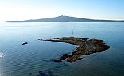
flows. The largest and most recent is Rangitoto
Rangitoto Island
Rangitoto Island is a volcanic island in the Hauraki Gulf near Auckland, New Zealand. The 5.5 km wide island is an iconic and widely visible landmark of Auckland with its distinctive symmetrical shield volcano cone rising 260 metres high over the Hauraki Gulf...
, which erupted in the Hauraki Gulf 600–700 years ago. Currently dormant, the field is likely to erupt again within the next "hundreds to thousands of years" (based on past events), a very short timeframe in geologic terms. Despite this, Auckland's residents face more danger from volcanoes further south.
Hotspot (geology)
The places known as hotspots or hot spots in geology are volcanic regions thought to be fed by underlying mantle that is anomalously hot compared with the mantle elsewhere. They may be on, near to, or far from tectonic plate boundaries. There are two hypotheses to explain them...
.
Waikato and South Auckland
Three volcanic fields erupted between 2.7 and 0.5 million years ago, migrating northwards from Mount PirongiaMount Pirongia
Mount Pirongia is an extinct volcano located in the Waikato region of New Zealand's North Island. It rises to 959 metres and is the highest peak in the Waikato region. It was active in the late Pliocene and early Pleistocene times...
to the Bombay Hills. These formed the Alexandra Volcanics, Ngatatura Volcanics and the South Auckland basalts respectively. The hot spot that created the Auckland Volcanic Field is considered to have caused these outpourings as well. Unlike typical hot spots such as the one underlying Hawaii
Hawaii hotspot
The Hawaii hotspot is the volcanic hotspot that created the Hawaiian Islands in the central Pacific Ocean, and is one of Earth's best-known and most heavily-studied hotspots....
, it does not seem to have stayed still, but instead is migrating northward at a faster pace than the surrounding Indo-Australian Plate. Its motion has been explained as the tip of a propagating crack produced by the twisting of the North Island's crust.
Coromandel Volcanic Zone
Great Barrier Island
Great Barrier Island is a large island of New Zealand, situated to the north-east of central Auckland in the outer Hauraki Gulf. With an area of it is the fourth-largest island of New Zealand's main chain of islands, with its highest point, Mount Hobson, rising...
in the north, through the Coromandel Peninsula
Coromandel Peninsula
The Coromandel Peninsula lies in the North Island of New Zealand. It is part of the Waikato Region and Thames-Coromandel District and extends 85 kilometres north from the western end of the Bay of Plenty, forming a natural barrier to protect the Hauraki Gulf and the Firth of Thames in the west...
, to Tauranga
Tauranga
Tauranga is the most populous city in the Bay of Plenty region, in the North Island of New Zealand.It was settled by Europeans in the early 19th century and was constituted as a city in 1963...
and the southern Kaimai Ranges
Kaimai Ranges
The Kaimai Range is a mountain range in the North Island of New Zealand. It is part of a series of ranges, with the Coromandel Range to the north and the Mamaku Ranges to the south. The Kaimai Range separates the Waikato in the west from the Bay of Plenty in the east.The highest point of the range...
in the south. Activity began in the north around 18 million years ago, and was primarily andesitic until around 9-10 million years ago, when it changed to a bimodal basaltic/rhyolitic pattern. Eruptive centres gradually migrated southward, where they transitioned into early activity in the Taupo Volcanic Zone. Later activity in the CVZ is obscured by subsequent events and is not fully understood, but continued in the south until around 1.9 million years ago. Together with the extinct undersea Colville Ridge, the CVZ formed a precursor to the modern Taupo Volcanic Zone and Kermadec Ridge.
Mayor Island
Peralkaline
Peralkaline rocks include those igneous rocks which have a deficiency of aluminium such that sodium and potassium are in excess of that needed for feldspar. The presence of aegerine and riebeckite are indicative of peralkaline conditions....
shield volcano with a caldera partly formed in a large eruption some 7000 years ago. It has exhibited many eruptive styles, and its last eruption may have occurred only 500–1000 years ago. The island's Maori name, Tuhua, refers to the obsidian they found on the island and prized for its sharp cutting edge.
Taupo Volcanic Zone
About 350 kilometres long by 50 kilometres wide, the Taupo Volcanic ZoneTaupo Volcanic Zone
The Taupo Volcanic Zone is a highly active volcanic V shaped area in the North Island of New Zealand that is spreading east -west at the rate of about 8mm per year...
(TVZ) is the world's most productive area of recent silicic
Silicic
Silicic is a term used to describe magma or igneous rock rich in silica. The amount of silica that constitutes a silicic rock is usually put at at least 65 percent. Granite and rhyolite are typical silicic rocks....
volcanic activity, with the highest concentration of young rhyolitic
Rhyolite
This page is about a volcanic rock. For the ghost town see Rhyolite, Nevada, and for the satellite system, see Rhyolite/Aquacade.Rhyolite is an igneous, volcanic rock, of felsic composition . It may have any texture from glassy to aphanitic to porphyritic...
volcanoes. Mount Ruapehu
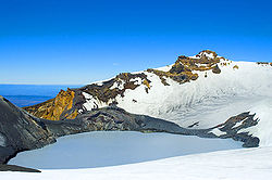
Mount Ruapehu
Mount Ruapehu, or just Ruapehu, is an active stratovolcano at the southern end of the Taupo Volcanic Zone in New Zealand. It is 23 kilometres northeast of Ohakune and 40 kilometres southwest of the southern shore of Lake Taupo, within Tongariro National Park...
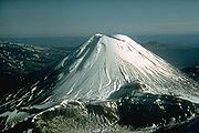
marks its southwestern end, and it continues up through Ngauruhoe
Mount Ngauruhoe
Mount Ngauruhoe is an active stratovolcano or composite cone in New Zealand, made from layers of lava and tephra. It is the youngest vent in the Tongariro volcanic complex on the Central Plateau of the North Island, and first erupted about 2,500 years ago...
, Tongariro, Lake Taupo
Lake Taupo
Lake Taupo is a lake situated in the North Island of New Zealand. With a surface area of , it is the largest lake by surface area in New Zealand, and the second largest freshwater lake by surface area in geopolitical Oceania after Lake Murray ....
, the Whakamaru, Mangakino, Maroa, Reporoa
Reporoa caldera
The Reporoa caldera is a 10 km by 15 km caldera in New Zealand's Taupo Volcanic Zone. It formed some 230,000 years ago, in a large eruption that deposited the approximately 100 km3 Kaingaroa Ignimbrites. It contains three rhyolitic lava domes and the active Reporoa geothermal field...
, and Rotorua
Rotorua Caldera
The Rotorua Caldera is one of several large volcanoes located in the Taupo Volcanic Zone on the North Island of New Zealand. Its last major eruption was about 240,000 years ago. At this time, the Mamaku ignimbrite, covering about 4000 square km, was deposited. After the eruption, the magma...
caldera
Caldera
A caldera is a cauldron-like volcanic feature usually formed by the collapse of land following a volcanic eruption, such as the one at Yellowstone National Park in the US. They are sometimes confused with volcanic craters...
s, the Okataina Volcanic Complex (including Mount Tarawera
Mount Tarawera
Mount Tarawera is the volcano responsible for New Zealand's largest historic eruption. Located 24 kilometres southeast of Rotorua in the North Island, it consists of a series of rhyolitic lava domes that were fissured down the middle by an explosive basaltic eruption in 1886, which killed over...
) and 85 kilometres beyond White Island
Whakaari/White Island
Whakaari/White Island is an active andesite stratovolcano, situated from the east coast of the North Island of New Zealand, in the Bay of Plenty. The nearest mainland towns are Whakatane and Tauranga....
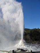
to the submarine Whakatane volcano. The TVZ also contains numerous smaller volcanoes, along with geyser
Geyser
A geyser is a spring characterized by intermittent discharge of water ejected turbulently and accompanied by a vapour phase . The word geyser comes from Geysir, the name of an erupting spring at Haukadalur, Iceland; that name, in turn, comes from the Icelandic verb geysa, "to gush", the verb...
s and geothermal
Geothermal
Geothermal is related to energy and may refer to:* The geothermal gradient and associated heat flows from within the Earth- Renewable technology :...
areas. Volcanic eruptions began here around two million years ago, with silicic eruptions starting around 1.55 million years ago, as activity shifted southeast from the Coromandel Volcanic Zone.
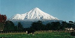
Taranaki
Volcanism in the Taranaki region has migrated southeastward during the last two million years. Beginning in the Sugar Loaf IslandsSugar Loaf Islands
The Sugar Loaf Islands are a collection of five small uninhabited islands and several sea stacks near Port Taranaki, Taranaki, New Zealand. The largest island, Moturoa Island, covers approximately...
, near New Plymouth
New Plymouth
New Plymouth is the major city of the Taranaki Region on the west coast of the North Island of New Zealand. It is named after Plymouth, Devon, England, from where the first English settlers migrated....
, activity then shifted to Kaitake (580,000 years ago) and Pouakai
Pouakai
Pouakai may refer to:* an alternative spelling of Poukai, a bird monster in Polynesian mythology who ate humans* Haast's Eagle, an extinct bird of New Zealand* an eroded, extinct volcano on the northern flank of Mount Taranaki...
(230,000 years ago) before creating the large stratovolcano called Taranaki or Mount Egmont, which last erupted in 1854, and its satellite vent Fanthams Peak.
Chatham Islands
The higher portions of the Chatham IslandsChatham Islands
The Chatham Islands are an archipelago and New Zealand territory in the Pacific Ocean consisting of about ten islands within a radius, the largest of which are Chatham Island and Pitt Island. Their name in the indigenous language, Moriori, means Misty Sun...
are formed from volcanic rock that is up to 81 million years old, although lava
Lava
Lava refers both to molten rock expelled by a volcano during an eruption and the resulting rock after solidification and cooling. This molten rock is formed in the interior of some planets, including Earth, and some of their satellites. When first erupted from a volcanic vent, lava is a liquid at...
flows on the northern shore of Chatham Island date back only about five million years.
Banks Peninsula

Banks Peninsula
Banks Peninsula is a peninsula of volcanic origin on the east coast of the South Island of New Zealand. It has an area of approximately and encompasses two large harbours and many smaller bays and coves...
comprises the eroded remnants of two large stratovolcanoes (Lyttelton formed first, then Akaroa). These formed through intraplate volcanism through continental crust
Continental crust
The continental crust is the layer of igneous, sedimentary, and metamorphic rocks which form the continents and the areas of shallow seabed close to their shores, known as continental shelves. This layer is sometimes called sial due to more felsic, or granitic, bulk composition, which lies in...
between approximately eleven and eight million years ago (Miocene
Miocene
The Miocene is a geological epoch of the Neogene Period and extends from about . The Miocene was named by Sir Charles Lyell. Its name comes from the Greek words and and means "less recent" because it has 18% fewer modern sea invertebrates than the Pliocene. The Miocene follows the Oligocene...
). The peninsula formed as offshore islands, with the volcanoes reaching to about 1,500 m above sea level. Two dominant craters were eroded, then flooded, to form the Lyttelton
Lyttelton, New Zealand
Lyttelton is a port town on the north shore of Lyttelton Harbour close to Banks Peninsula, a suburb of Christchurch on the eastern coast of the South Island of New Zealand....
and Akaroa
Akaroa
Akaroa is a village on Banks Peninsula in the Canterbury region of the South Island of New Zealand, situated within a harbour of the same name—the name Akaroa is Kāi Tahu Māori for 'Long Harbour'.- Overview :...
Harbours. The portion of crater rim lying between Lyttelton Harbour and Christchurch city forms the Port Hills
Port Hills
The Port Hills form the northern rim of the ancient Lyttelton volcano, separating the port of Lyttelton from the city of Christchurch in Canterbury, New Zealand...
.
Oamaru
Small SurtseyanSurtseyan eruption
A Surtseyan eruption is a type of volcanic eruption that takes place in shallow seas or lakes. It is named after the island of Surtsey off the southern coast of Iceland....
volcanoes on the submerged continental shelf
Continental shelf
The continental shelf is the extended perimeter of each continent and associated coastal plain. Much of the shelf was exposed during glacial periods, but is now submerged under relatively shallow seas and gulfs, and was similarly submerged during other interglacial periods. The continental margin,...
formed the Waiareka-Deborah volcanic group in the area around Oamaru
Oamaru
Oamaru , the largest town in North Otago, in the South Island of New Zealand, is the main town in the Waitaki District. It is 80 kilometres south of Timaru and 120 kilometres north of Dunedin, on the Pacific coast, and State Highway 1 and the railway Main South Line connects it to both...
around 35 to 30 million years ago ago.
Dunedin
The Dunedin Volcanic Complex formed during the Miocene, beginning with basaltic eruptions on the Otago PeninsulaOtago Peninsula
The Otago Peninsula is a long, hilly indented finger of land that forms the easternmost part of Dunedin, New Zealand. Volcanic in origin, it forms one wall of the eroded valley that now forms Otago Harbour. The peninsula lies south-east of Otago Harbour and runs parallel to the mainland for...
. Large central-vent structures formed, and then large domes - with seawater interacting explosively with erupting submarine magma.
Solander Islands
The Solander IslandsSolander Islands
The Solander Islands are a small chain of uninhabited volcanic islets lying at , close to the western end of the Foveaux Strait in southern New Zealand...
, a small chain of uninhabited islets close to the western end of the Foveaux Strait
Foveaux Strait
Foveaux Strait separates Stewart Island/Rakiura, New Zealand's third largest island, from the South Island. Three large bays, Te Waewae Bay, Oreti Beach and Toetoes Bay, sweep along the strait's northern coast, which also hosts Bluff township and harbour. Across the strait lie the Solander...
, are the emergent portions of a large extinct andesitic volcano that last erupted around 150,000 to 400,000 years ago. Caused by the subduction of the Australian Plate beneath the Pacific Plate, it is the only volcano associated with this subduction zone that protrudes above the sea.
Sub-Antarctic islands
The majority of New Zealand's widely separated sub-Antarctic islandsNew Zealand sub-antarctic islands
The five southernmost groups of the New Zealand Outlying Islands form the New Zealand Sub-Antarctic islands. These islands are collectively designated as an UNESCO World Heritage Site....
are primarily volcanic in origin, including Auckland Island
Auckland Island
Auckland Island is the main island of the Auckland Islands, an uninhabited archipelago in the south Pacific Ocean belonging to New Zealand. It is inscribed in the together with the other subantarctic New Zealand islands in the region as follows: 877-004 Auckland Isls, New Zealand S50.29 E165.52...
, Campbell Island
Campbell Island, New Zealand
Campbell Island is a remote, subantarctic island of New Zealand and the main island of the Campbell Island group. It covers of the group's , and is surrounded by numerous stacks, rocks and islets like Dent Island, Folly Island , Isle de Jeanette Marie, and Jacquemart Island, the latter being the...
, and Antipodes Island. These are mainly Miocene
Miocene
The Miocene is a geological epoch of the Neogene Period and extends from about . The Miocene was named by Sir Charles Lyell. Its name comes from the Greek words and and means "less recent" because it has 18% fewer modern sea invertebrates than the Pliocene. The Miocene follows the Oligocene...
intraplate volcanoes with ages decreasing towards the northeast, although Antipodes Island may have been active during the last 20,000 years.
Older volcanism
Older remnants of volcanism are also found in several places around New Zealand. These were generally formed either when New Zealand still formed part of the GondwanaGondwana
In paleogeography, Gondwana , originally Gondwanaland, was the southernmost of two supercontinents that later became parts of the Pangaea supercontinent. It existed from approximately 510 to 180 million years ago . Gondwana is believed to have sutured between ca. 570 and 510 Mya,...
supercontinent
Supercontinent
In geology, a supercontinent is a landmass comprising more than one continental core, or craton. The assembly of cratons and accreted terranes that form Eurasia qualifies as a supercontinent today.-History:...
, or while Zealandia
Zealandia (continent)
Zealandia , also known as Tasmantis or the New Zealand continent, is a nearly submerged continental fragment that sank after breaking away from Australia 60–85 million years ago, having separated from Antarctica between 85 and 130 million years ago...
was rifting away from the rest of Gondwana, although some have been emplaced in their current setting more recently. (New Zealand is the main part of the submerged microcontinent of Zealandia that currently emerges above the sea.)
A band of granitic intrusions covering over 10,000 km², the Median Batholith, stretches from Stewart Island through Fiordland
Fiordland
Fiordland is a geographic region of New Zealand that is situated on the south-western corner of the South Island, comprising the western-most third of Southland. Most of Fiordland is dominated by the steep sides of the snow-capped Southern Alps, deep lakes and its ocean-flooded, steep western valleys...
, and again through the West Coast and Nelson
Nelson, New Zealand
Nelson is a city on the eastern shores of Tasman Bay, and is the economic and cultural centre of the Nelson-Tasman region. Established in 1841, it is the second oldest settled city in New Zealand and the oldest in the South Island....
after interruption by the Alpine Fault
Alpine Fault
The Alpine Fault is a geological fault, more specifically known as a right-lateral strike-slip fault, that runs almost the entire length of New Zealand's South Island. It forms a transform boundary between the Pacific Plate and the Indo-Australian Plate. Earthquakes along the fault, and the...
. This was produced between 375 and 105 million years ago in the course of subduction-related volcanism in a long mountain range along the Gondwanan coast somewhat like today's Andes
Andes
The Andes is the world's longest continental mountain range. It is a continual range of highlands along the western coast of South America. This range is about long, about to wide , and of an average height of about .Along its length, the Andes is split into several ranges, which are separated...
. Two more batholith
Batholith
A batholith is a large emplacement of igneous intrusive rock that forms from cooled magma deep in the Earth's crust...
s, the Karamea-Paparoa and Hohonu Batholiths, are also found on the West Coast.
Dike (geology)
A dike or dyke in geology is a type of sheet intrusion referring to any geologic body that cuts discordantly across* planar wall rock structures, such as bedding or foliation...
s, and tuff from fissure eruptions between 100 million and 65 million years ago, during Zealandia's separation from Gondwana, are found in Marlborough, the West Coast and offshore further west. Ultramafic intrusions are found in Marlborough and north Canterbury, including at the summit of Tapuae-o-Uenuku
Mount Tapuaenuku
Tapuae-o-Uenuku, formerly Mount Tapuaenuku, is the highest peak in the northeast of New Zealand's South Island. The name translates from Māori as "footprint of the rainbow", though is usually regarded as being named after Chief Tapuaenuku....
, the country's highest mountain outside the Southern Alps
Southern Alps
The Southern Alps is a mountain range extending along much of the length of New Zealand's South Island, reaching its greatest elevations near the island's western side...
.
Rhyolitic ignimbrite from 85 million years ago is found in Otago
Otago
Otago is a region of New Zealand in the south of the South Island. The region covers an area of approximately making it the country's second largest region. The population of Otago is...
at Shag Point and in the Kakanui Mountains.
The Hikurangi Plateau
Hikurangi Plateau
Hikurangi Plateau is an Early Cretaceous basaltic oceanic plateau in the southwestern Pacific Ocean. The portion of the plateau exposed on the seafloor has an area of 350,000 km2, and including the portions subducted beneath the...
is an oceanic plateau
Oceanic plateau
An oceanic plateau is a large, relatively flat submarine region that rises well above the level of the ambient seabed. While many oceanic plateaus are composed of continental crust, and often form a step interrupting the continental slope, some plateaus are undersea remnants of large igneous...
on the Pacific Plate that attached to the Chatham Ridge after partially subducted under it, and is now subducting under the North Island
North Island
The North Island is one of the two main islands of New Zealand, separated from the much less populous South Island by Cook Strait. The island is in area, making it the world's 14th-largest island...
. It likely formed in one of the world's largest volcanic outpourings, the greater Ontong Java event
Ontong Java Plateau
The Ontong Java Plateau is a huge oceanic plateau located in the Pacific Ocean, lying north of the Solomon Islands. The plateau covers an area of approximately , or roughly the size of Alaska, and reaches a thickness of up to . The plateau is of volcanic origin, composed mostly of flood basalts...
.
Ophiolites, volcanic deposits from the ocean floor, have been incorporated into the continental basement of New Zealand in the Dun Mountain Ophiolite Belt, found at both ends of the South Island
South Island
The South Island is the larger of the two major islands of New Zealand, the other being the more populous North Island. It is bordered to the north by Cook Strait, to the west by the Tasman Sea, to the south and east by the Pacific Ocean...
, and in Northland.
See also
- List of volcanoes in New Zealand
- List of volcanoes in Antarctica (for volcanoes in New Zealand's Ross DependencyRoss DependencyThe Ross Dependency is a region of Antarctica defined by a sector originating at the South Pole, passing along longitudes 160° east to 150° west, and terminating at latitude 60° south...
) - Earthquakes in New ZealandEarthquakes in New ZealandEarthquakes in New Zealand occur as the country forms part of the Pacific Ring of Fire, which is geologically active. About 20,000 earthquakes, most of them minor, are recorded each year. About 200 of these are strong enough to be felt...
- Geothermal areas in New ZealandGeothermal areas in New ZealandNew Zealand is a geologically active country with numerous geothermal features, including volcanoes, hot springs, geysers and volcanic lakes. Many of these features are clustered together, and they are particularly abundant throughout the central North Island's Taupo Volcanic Zone...
- List of New Zealand disasters by death toll
- Volcanism of Canada
- Volcanism of Italy
- Volcanism of Iceland