
List of New Zealand disasters by death toll
Encyclopedia
This is a list of New Zealand disasters by death toll, listing major disasters (excluding epidemics and acts of war
) which occurred in New Zealand
and its territories or involved a significant number of New Zealand citizens, in a specific incident, where the loss of life was 10 or more.


}
|Central Otago goldfields
|
|-
|79
|Fiery Star
|shipwreck
|
|240 km off the Chatham Islands
|
|-
|79
|Matoaka
| shipwreck (presumed)
|
|between Lyttelton
and London
|
|-
|75
|SS Penguin
|shipwreck
|
|off Cape Terawhiti
|
|-
|68
|General Grant
|shipwreck
|
|Auckland Island
|
|-
|65
|Brunner Mine disaster
|mine accident
|
|Brunner
|
|-
|65
|Little Waihi Landslide
|landslide
|
|Waihi Village
|
|-
|53
| Wahine disaster
| shipwreck
|
| Barrett Reef
, Wellington Harbour
|
|-
|48
| Featherston prisoner of war camp
riot
| riot
|
| Featherston, New Zealand
|
|-
|45
| SS Elingamite
| shipwreck
|
| off West Island in the Three Kings Islands
|
|-
|43
|Ralph's Mine
| mine accident
|
|Huntly
|
|-
|41
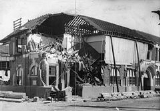
|Ballantyne's store disaster
|fire
|
|Christchurch
|
|-
|39
|City of Dunedin
|shipwreck
|
|Cook Strait
|
|-
|37
|Seacliff Lunatic Asylum
|fire
|
|Seacliff
|
|-
|34
|SS Taiaroa
|shipwreck
|
|Clarence River mouth
|
|-
|34
| Kaitangata mine
| mine explosion
|
| Kaitangata
|
|-
|34
|Dunedin
| shipwreck (presumed)
|
|between Oamaru
and London
|
|-
|30
|Marlborough
| shipwreck (presumed)
|
|between Lyttelton
and London
|
|-
|29
|Pike River Mine disaster
|mine explosion
|
| northwest of Greymouth
|
|-
|29
|MV Kaitawa
|shipwreck
|
|near Pandora Bank, Cape Reinga
|
|-
|26
|Barque Maria
|shipwreck
|
|Cape Terawhiti
|
|-
|25+
|Great storm of 1868, flash floods and 12 shipwrecks
|storm
|
|
|
|-
|24
|Assaye
| shipwreck (presumed)
|
|between London
and Wellington
; wreckage washed up at the Chatham Islands 7 months after the ship left London
|
|-
|23
| New Zealand National Airways Corporation Flight 441
| air accident
|
| Kaimai Ranges
|
|-
|22
|launch Ranui
|shipwreck
|
|off Mount Maunganui
, Bay of Plenty
|
|-
|21
|Hyde railway disaster
| rail accident
|
|near Hyde
|
|-
|21
| railway workers camp
| flood
|
|Kopuawhara
|
|-
|21
|brigantine Sophia Pate
|shipwreck
|
|Kaipara Harbour
|
|-
|20
|schooner St. Vincent
|shipwreck
|
|Palliser Bay
|
|-
|19
|Strongman Mine
|mine explosion
|
|near Greymouth
|
|-
|18
|Clyde
|shipwreck
|
|Horseshoe Bay, near Akaroa
, Banks Peninsula
|
|-
|18
|Lastingham
|shipwreck
|
|Cape Jackson
, Cook Strait
|
|-
|18
|schooners Enterprise and Tauranga
| shipwreck
|
|between Cape Rodney and Sail Rock, Hauraki Gulf
|
|-
|17
|1929 Murchison earthquake
|earthquake
|
|Murchison
|
|-
|17
|
|rail accident
|
|Ongarue
|
|-
|16
|Capitaine Bougainville
|shipwreck
|
|Whananaki
|
|-
|16
|1943 Liberator crash at Whenuapai
|air accident
|
|Whenuapai
|
|-
|15
|Brynderwyns bus accident
| road accident
|
|Brynderwyn Hills
|
|-
|15
|MV Holmglen
|shipwreck
|
|near Timaru
|
|-
|15
|
|air accident
|
|near Waikanae
|
|-
|15
|Derry Castle
|shipwreck
|
|Enderby Island, Auckland Islands
|
|-
|14
| Cave Creek disaster
| structural failure
|
| Paparoa National Park
|
|-
|14
|Aramoana massacre
|spree killing
|
|Aramoana
, near Dunedin
|
|-
|14
|
|floods
|
|Hutt Valley
|
|-
|13
|NAC Electra air crash
|air accident
|
|on Ruapehu
|
|-
|13
|SS Ventnor
|shipwreck
|
|off Omapere, Hokianga
|
|-
|13
|Tasmania
|shipwreck
|
|Mahia Peninsula
|
|-
|12
|barque Dundonald
|shipwreck
|
|Disappointment Island
, Auckland Islands
|
|-
|12
|Barque Lizzie Bell
|shipwreck
|
|Waimate
, Taranaki
|
|-
|12
|
|floods
|
|Clive, Hawkes Bay
|
|-
|12
|Zuleika
|shipwreck
|
|near Cape Palliser
|
|-
|12
|Octagon
building fire
|fire
|
|Dunedin
|
|-
|12
|ferry Pride of the Yarra and paddle steamer Favourite
|collision
|
|Otago Harbour
|
|-
|12
|Alcmène
|shipwreck
|
|Baylys Beach, Kaipara
|
|-
|11
|Glen Afton mine, carbon monoxide asphyxiation
|mine disaster
|
|Huntly
|
|-
|10
|Aspiring Air
Britten-Norman Islander
, collided with terrain
|air crash
|
|Upper Dart Valley
|
|-
|10
|Husky and Argo lost to storm in yacht race
|shipwrecks
|
|between Wellington and Christchurch
|
|-
|10
|sulphur mine destroyed
|lahar
|
|Whakaari/White Island
|
|}
War
War is a state of organized, armed, and often prolonged conflict carried on between states, nations, or other parties typified by extreme aggression, social disruption, and usually high mortality. War should be understood as an actual, intentional and widespread armed conflict between political...
) which occurred in New Zealand
New Zealand
New Zealand is an island country in the south-western Pacific Ocean comprising two main landmasses and numerous smaller islands. The country is situated some east of Australia across the Tasman Sea, and roughly south of the Pacific island nations of New Caledonia, Fiji, and Tonga...
and its territories or involved a significant number of New Zealand citizens, in a specific incident, where the loss of life was 10 or more.
List of disasters
| Deaths | Name or description | Type | Date | Location | Notes |
|---|---|---|---|---|---|
| 257 | Air New Zealand Flight 901 Air New Zealand Flight 901 Air New Zealand Flight 901 was a scheduled Air New Zealand Antarctic sightseeing flight that operated between 1977 and 1979, from Auckland Airport to Antarctica and return via Christchurch... |
Air accident | Mt Erebus, Ross Dependency Ross Dependency The Ross Dependency is a region of Antarctica defined by a sector originating at the South Pole, passing along longitudes 160° east to 150° west, and terminating at latitude 60° south... , Antarctica |
Controlled flight into terrain Controlled flight into terrain Controlled flight into terrain describes an accident in which an airworthy aircraft, under pilot control, is unintentionally flown into the ground, a mountain, water, or an obstacle. The term was coined by engineers at Boeing in the late 1970s... caused by navigation computer error, organisational error and inadequate training |
|
| 256 | 1931 Hawke's Bay earthquake 1931 Hawke's Bay earthquake The 1931 Hawke's Bay earthquake, also known as the Napier earthquake, occurred in New Zealand at 10:47 am on Tuesday 3 February 1931, killing 256 and devastating the Hawke's Bay region. It remains New Zealand's deadliest natural disaster... |
earthquake Earthquake An earthquake is the result of a sudden release of energy in the Earth's crust that creates seismic waves. The seismicity, seismism or seismic activity of an area refers to the frequency, type and size of earthquakes experienced over a period of time... |
20 km north of Napier Napier, New Zealand Napier is a New Zealand city with a seaport, located in Hawke's Bay on the eastern coast of the North Island. The population of Napier is about About 18 kilometres south of Napier is the inland city of Hastings. These two neighboring cities are often called "The Twin Cities" or "The Bay Cities"... |
||
| 189 | HMS Orpheus HMS Orpheus (1861) HMS Orpheus was a Jason-class Royal Navy corvette that served as the flagship of the Australian squadron. Orpheus sank off the west coast of Auckland, New Zealand on 7 February 1863: 189 crew out of the ship's complement of 259 died in the disaster, making it the worst maritime tragedy to occur in... |
shipwreck | off the Manukau Heads Manukau Heads The Manukau Heads is the name given to the two promontories that form the entrance to the Manukau Harbour - one of the two harbours of Auckland in New Zealand. The southern head is simply termed "The South Head", whereas the northern head is named "Burnett Head"... near Auckland Auckland The Auckland metropolitan area , in the North Island of New Zealand, is the largest and most populous urban area in the country with residents, percent of the country's population. Auckland also has the largest Polynesian population of any city in the world... |
||
| 181 | February 2011 Christchurch earthquake | earthquake | Christchurch Christchurch Christchurch is the largest city in the South Island of New Zealand, and the country's second-largest urban area after Auckland. It lies one third of the way down the South Island's east coast, just north of Banks Peninsula which itself, since 2006, lies within the formal limits of... |
||
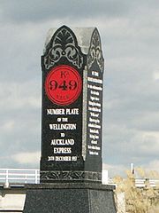
| 151 | Tangiwai disaster Tangiwai disaster The Tangiwai disaster on 24 December 1953 was the worst rail accident in New Zealand history. An 11-carriage overnight express from Wellington to Auckland fell into the Whangaehu River at Tangiwai, ten kilometres west of Waiouru. The bridge carrying the North Island Main Trunk Railway over the... |
rail accident / lahar Lahar A lahar is a type of mudflow or debris flow composed of a slurry of pyroclastic material, rocky debris, and water. The material flows down from a volcano, typically along a river valley. The term is a shortened version of "berlahar" which originated in the Javanese language of... |
NIMT Whangaehu River Whangaehu River The Whangaehu River is a large river in central North Island of New Zealand. Its headwaters are the crater lake of Mount Ruapehu on the central plateau, and it flows into the Tasman Sea eight kilometres southeast of Wanganui.-Length:... bridge, between Waiouru Waiouru Waiouru is a small town in the centre of the North Island of New Zealand. It is on the North Island Volcanic Plateau, 25 kilometres south-east of Mount Ruapehu, and in the Ruapehu District.... and Ohakune Ohakune Ohakune is a town in the North Island of New Zealand. It is located at the southern end of the Tongariro National Park, close to the southwestern slopes of the active volcano Mount Ruapehu. Part of the Manawatu-Wanganui region, the town is 70 kilometres northeast of Wanganui, and 25 kilometres west... |
rail bridge destroyed by lahar Lahar A lahar is a type of mudflow or debris flow composed of a slurry of pyroclastic material, rocky debris, and water. The material flows down from a volcano, typically along a river valley. The term is a shortened version of "berlahar" which originated in the Javanese language of... from Mount Ruapehu Mount Ruapehu Mount Ruapehu, or just Ruapehu, is an active stratovolcano at the southern end of the Taupo Volcanic Zone in New Zealand. It is 23 kilometres northeast of Ohakune and 40 kilometres southwest of the southern shore of Lake Taupo, within Tongariro National Park... |
|
| 135+ | landslide | Te Rapa/Waihi Village Waihi Village Waihi Village, also known as Little Waihi, is a small Māori community of around 25 households. on the southwestern shores of Lake Taupo seven kilometres northwest of Turangi, New Zealand. It has been the site of three major landslides, in 1910, 1846 and around 1780, which killed over 200 people in... |
|||
| 131 | SS Tararua SS Tararua SS Tararua was a passenger steamer that struck the reef off Waipapa Point in the Catlins on 29 April 1881, and sank the next day, in the worst civilian shipping disaster in New Zealand's history. Of the 151 passengers and crew on board, only 20 survived the shipwreck.-Ship:The Tararua was a... |
shipwreck | off Waipapa Point Waipapa Point Waipapa Point is a rocky promontory on the south coast of the South Island of New Zealand. It is located southeast of the mouth of the Mataura River, at the extreme southwestern end of the area known as the Catlins.... |
||
| 121 | SS Wairarapa SS Wairarapa The SS Wairarapa was a New Zealand ship of the late 19th century plying the route between the Auckland, New Zealand and Australia. It came to tragic fame when it hit a reef at the northern edge of Great Barrier Island, about 100 km out from Auckland, and sunk. The death toll of around 140 people... |
shipwreck | off Great Barrier Island Great Barrier Island Great Barrier Island is a large island of New Zealand, situated to the north-east of central Auckland in the outer Hauraki Gulf. With an area of it is the fourth-largest island of New Zealand's main chain of islands, with its highest point, Mount Hobson, rising... |
||
| 108–153 | Mount Tarawera eruption | volcanic eruption | Mount Tarawera Mount Tarawera Mount Tarawera is the volcano responsible for New Zealand's largest historic eruption. Located 24 kilometres southeast of Rotorua in the North Island, it consists of a series of rhyolitic lava domes that were fissured down the middle by an explosive basaltic eruption in 1886, which killed over... |
||
| 100–200 | floods and snowstorms |
|Central Otago goldfields
Central Otago Gold Rush
The Central Otago Gold Rush was a gold rush that occurred during the 1860s in Central Otago, New Zealand...
|
|-
|79
|Fiery Star
|shipwreck
|
|240 km off the Chatham Islands
Chatham Islands
The Chatham Islands are an archipelago and New Zealand territory in the Pacific Ocean consisting of about ten islands within a radius, the largest of which are Chatham Island and Pitt Island. Their name in the indigenous language, Moriori, means Misty Sun...
|
|-
|79
|Matoaka
| shipwreck (presumed)
|
|between Lyttelton
Lyttelton, New Zealand
Lyttelton is a port town on the north shore of Lyttelton Harbour close to Banks Peninsula, a suburb of Christchurch on the eastern coast of the South Island of New Zealand....
and London
London
London is the capital city of :England and the :United Kingdom, the largest metropolitan area in the United Kingdom, and the largest urban zone in the European Union by most measures. Located on the River Thames, London has been a major settlement for two millennia, its history going back to its...
|
|-
|75
|SS Penguin
SS Penguin
SS Penguin was a New Zealand 824 ton inter-island ferry steamer that sank off Cape Terawhiti near the entrance to Wellington Harbour in poor weather on 12 February 1909, and subsequently exploded as cold sea water flooded into the red-hot boiler room. Of the 105 passengers and crew on board, only...
|shipwreck
|
|off Cape Terawhiti
Cape Terawhiti
Cape Terawhiti is the southwesternmost point of the North Island of New Zealand.The cape is located 16 kilometres to the west of Wellington, the capital city of New Zealand...
|
|-
|68
|General Grant
General Grant (ship)
The General Grant was a 1,005-ton three-masted barque built in Maine, USA in 1864 and registered in Boston, USA. She was named after Ulysses S. Grant, owned by Messers Boyes, Richardson & Co...
|shipwreck
|
|Auckland Island
Auckland Island
Auckland Island is the main island of the Auckland Islands, an uninhabited archipelago in the south Pacific Ocean belonging to New Zealand. It is inscribed in the together with the other subantarctic New Zealand islands in the region as follows: 877-004 Auckland Isls, New Zealand S50.29 E165.52...
|
|-
|65
|Brunner Mine disaster
Brunner Mine disaster
An explosion deep in the Brunner Mine at 9:30am on Thursday 26 March 1896 killed all 65 miners inside, and was the worst mining disaster of New Zealand’s history....
|mine accident
|
|Brunner
Brunner, New Zealand
Brunner is a town in the northwest of New Zealand's South Island. Together with Taylorville and Dobson to the south-west, it had a population of 672 at the 2006 census. It is 12 kilometres to the east of Greymouth, on the south bank of the Grey River. It is on the Midland Line railway near its...
|
|-
|65
|Little Waihi Landslide
|landslide
|
|Waihi Village
Waihi Village
Waihi Village, also known as Little Waihi, is a small Māori community of around 25 households. on the southwestern shores of Lake Taupo seven kilometres northwest of Turangi, New Zealand. It has been the site of three major landslides, in 1910, 1846 and around 1780, which killed over 200 people in...
|
|-
|53
| Wahine disaster
Wahine disaster
The Wahine disaster occurred on 10 April 1968 when the TEV Wahine, a New Zealand inter-island ferry of the Union Company, foundered on Barrett Reef at the entrance to Wellington Harbour and capsized near Steeple Rock...
| shipwreck
|
| Barrett Reef
Barrett Reef
The cluster of rocks that is Barrett Reef is one of the most treacherous reefs in New Zealand.It lies on the western side of the entrance of Wellington Harbour, on the approaches to the city of Wellington, at coordinates . The reef is named after Richard Barrett , a whaler and trader. Its Maori...
, Wellington Harbour
Wellington Harbour
Wellington Harbour is the large natural harbour at the southern tip of New Zealand's North Island. New Zealand's capital, Wellington, is on the western side of Wellington Harbour. The harbour was officially named Port Nicholson until it assumed its current name in the 1980s.In Māori the harbour is...
|
|-
|48
| Featherston prisoner of war camp
Featherston prisoner of war camp
Featherston prisoner of war camp was a camp for captured Japanese soldiers during World War II at Featherston, New Zealand. It had been established during World War I as the largest military training camp in New Zealand. At the request of the United States, in September 1942 it was re-established...
riot
| riot
|
| Featherston, New Zealand
Featherston, New Zealand
Featherston is a town in the north of the Wellington Region region of New Zealand. It lies in the Wairarapa, just north of the Rimutaka Tunnel, in the South Wairarapa District. The population was 2,340 in the 2006 Census....
|
|-
|45
| SS Elingamite
SS Elingamite
SS Elingamite was a single screw passenger steamer of 2585 tons, built in 1887 and owned by Huddart Parker. The ship was wrecked in 1902 off the north coast of New Zealand carrying a large consignment of gold...
| shipwreck
|
| off West Island in the Three Kings Islands
Three Kings Islands
The Three Kings Islands or Manawa Islands are a group of 13 islands about northwest of Cape Reinga, the northernmost point of the North Island of New Zealand, where the South Pacific Ocean and Tasman Sea converge. They measure about 4.86 km² in area...
|
|-
|43
|Ralph's Mine
| mine accident
|
|Huntly
Huntly, New Zealand
Huntly is a town in the Waikato region of the North Island of New Zealand. It is on State Highway 1, 93 kilometres south of Auckland and 35 kilometres north of Hamilton. It is situated on the North Island Main Trunk Railway and straddles the Waikato River.Huntly was called Rahui Pokeka when...
|
|-
|41
|Ballantyne's store disaster
Ballantyne's store disaster
The Ballantyne's fire on 18 November 1947 remains the deadliest fire in New Zealand history. Forty one people died in the blaze in the Christchurch Central City; all were employees who found themselves trapped by the fire or were overcome by smoke while evacuating the store complex without a fire...
|fire
|
|Christchurch
Christchurch
Christchurch is the largest city in the South Island of New Zealand, and the country's second-largest urban area after Auckland. It lies one third of the way down the South Island's east coast, just north of Banks Peninsula which itself, since 2006, lies within the formal limits of...
|
|-
|39
|City of Dunedin
|shipwreck
|
|Cook Strait
|
|-
|37
|Seacliff Lunatic Asylum
Seacliff Lunatic Asylum
Seacliff Lunatic Asylum was a psychiatric hospital in Seacliff, New Zealand. When built in the late 19th century, it was the largest building in the country, noted for its scale and extravagant architecture...
|fire
|
|Seacliff
Seacliff, New Zealand
Seacliff is a small village located north of Dunedin in the Otago region of New Zealand's South Island. The village lies roughly half way between the estuary of Blueskin Bay and the mouth of the Waikouaiti River at Karitane, on the eastern slopes of Kilmog hill...
|
|-
|34
|SS Taiaroa
|shipwreck
|
|Clarence River mouth
|
|-
|34
| Kaitangata mine
| mine explosion
|
| Kaitangata
Kaitangata, New Zealand
Kaitangata is a town near the coast of South Otago, New Zealand, on the left bank of the Clutha River ten kilometres south east of Balclutha. The town is known to its residents simply as Kai....
|
|-
|34
|Dunedin
Dunedin (ship)
The Dunedin was the first ship to complete a truly successful transport of refrigerated meat. In its capacity, it helped set the stage for New Zealand's success as a major provider of agricultural exports, notwithstanding its extreme remoteness from most markets.-Ship origins:The 1,320-ton, ...
| shipwreck (presumed)
|
|between Oamaru
Oamaru
Oamaru , the largest town in North Otago, in the South Island of New Zealand, is the main town in the Waitaki District. It is 80 kilometres south of Timaru and 120 kilometres north of Dunedin, on the Pacific coast, and State Highway 1 and the railway Main South Line connects it to both...
and London
London
London is the capital city of :England and the :United Kingdom, the largest metropolitan area in the United Kingdom, and the largest urban zone in the European Union by most measures. Located on the River Thames, London has been a major settlement for two millennia, its history going back to its...
|
|-
|30
|Marlborough
Marlborough (ship)
The Marlborough was a large iron-built sailing merchant ship which disappeared in 1890. She was built by the firm of Robert Duncan and Co., Port Glasgow and launched in 1876 for her owner Mr. J...
| shipwreck (presumed)
|
|between Lyttelton
Lyttelton, New Zealand
Lyttelton is a port town on the north shore of Lyttelton Harbour close to Banks Peninsula, a suburb of Christchurch on the eastern coast of the South Island of New Zealand....
and London
London
London is the capital city of :England and the :United Kingdom, the largest metropolitan area in the United Kingdom, and the largest urban zone in the European Union by most measures. Located on the River Thames, London has been a major settlement for two millennia, its history going back to its...
|
|-
|29
|Pike River Mine disaster
Pike River Mine disaster
The Pike River Mine disaster was a coal mining accident that began on 19 November 2010 in the Pike River Mine, northeast of Greymouth, in the West Coast Region of New Zealand's South Island. A first explosion occurred in the mine at approximately 3:44 pm . At the time of the explosion 31...
|mine explosion
|
| northwest of Greymouth
Greymouth
Greymouth is the largest town in the West Coast region in the South Island of New Zealand, and the seat of the Grey District Council. The population of the whole Grey District is , which accounts for % of the West Coast's inhabitants...
|
|-
|29
|MV Kaitawa
|shipwreck
|
|near Pandora Bank, Cape Reinga
Cape Reinga
Cape Reinga is the northwesternmost tip of the Aupouri Peninsula, at the northern end of the North Island of New Zealand. Cape Reinga is located over 100 km north of the nearest small town of Kaitaia. State Highway 1 extends all the way to the Cape, but until 2010 was unsealed gravel road for the...
|
|-
|26
|Barque Maria
|shipwreck
|
|Cape Terawhiti
Cape Terawhiti
Cape Terawhiti is the southwesternmost point of the North Island of New Zealand.The cape is located 16 kilometres to the west of Wellington, the capital city of New Zealand...
|
|-
|25+
|Great storm of 1868, flash floods and 12 shipwrecks
|storm
|
|
|
|-
|24
|Assaye
| shipwreck (presumed)
|
|between London
London
London is the capital city of :England and the :United Kingdom, the largest metropolitan area in the United Kingdom, and the largest urban zone in the European Union by most measures. Located on the River Thames, London has been a major settlement for two millennia, its history going back to its...
and Wellington
Wellington
Wellington is the capital city and third most populous urban area of New Zealand, although it is likely to have surpassed Christchurch due to the exodus following the Canterbury Earthquake. It is at the southwestern tip of the North Island, between Cook Strait and the Rimutaka Range...
; wreckage washed up at the Chatham Islands 7 months after the ship left London
|
|-
|23
| New Zealand National Airways Corporation Flight 441
New Zealand National Airways Corporation Flight 441
New Zealand National Airways Corporation Flight 441 was a scheduled flight of New Zealand's National Airways Corporation from Whenuapai to Tauranga. On 3 July 1963 at approximately 9:09 am NZST the flight, a Douglas DC-3 Skyliner, flew into a vertical rock face in the Kaimai Ranges near Mount...
| air accident
|
| Kaimai Ranges
Kaimai Ranges
The Kaimai Range is a mountain range in the North Island of New Zealand. It is part of a series of ranges, with the Coromandel Range to the north and the Mamaku Ranges to the south. The Kaimai Range separates the Waikato in the west from the Bay of Plenty in the east.The highest point of the range...
|
|-
|22
|launch Ranui
|shipwreck
|
|off Mount Maunganui
Mount Maunganui
Mount Maunganui is a town in the Bay of Plenty, New Zealand, located on a peninsula to the north of Tauranga. It was independent from Tauranga until the completion of the Tauranga Harbour Bridge in 1988....
, Bay of Plenty
|
|-
|21
|Hyde railway disaster
Hyde railway disaster
The Hyde railway disaster occurred on 4 June 1943 near the small settlement of Hyde, New Zealand on a bend of the Otago Central Railway. At the time, it was New Zealand's worst railway accident; of the 113 passengers on board, 21 were killed and a further 47 were injured. But just over ten years...
| rail accident
|
|near Hyde
Hyde, New Zealand
Hyde is a locality in Otago, New Zealand, located in the Strath-Taieri. It is close to the northern end of the Rock and Pillar Range on State Highway 87 between Middlemarch and Ranfurly....
|
|-
|21
| railway workers camp
| flood
|
|Kopuawhara
|
|-
|21
|brigantine Sophia Pate
|shipwreck
|
|Kaipara Harbour
Kaipara Harbour
Kaipara Harbour is a large enclosed harbour estuary complex on the north western side of the North Island of New Zealand. The northern part of the harbour is administered by the Kaipara District and the southern part is administered by the Rodney District...
|
|-
|20
|schooner St. Vincent
|shipwreck
|
|Palliser Bay
Palliser Bay
Palliser Bay is located at the southern end of the North Island of New Zealand, to the southeast of Wellington. It runs for 40 kilometres along the Cook Strait coast from Turakirae Head at the southern end of the Rimutaka Ranges to Cape Palliser, the North Island's southernmost point.Inland from...
|
|-
|19
|Strongman Mine
Strongman Mine
The Strongman Mine was an underground coal mine north of Greymouth on the West Coast of New Zealand from 1938 to 2003.On 19 January 1967 a gas explosion in the mine killed 19 miners....
|mine explosion
|
|near Greymouth
Greymouth
Greymouth is the largest town in the West Coast region in the South Island of New Zealand, and the seat of the Grey District Council. The population of the whole Grey District is , which accounts for % of the West Coast's inhabitants...
|
|-
|18
|Clyde
|shipwreck
|
|Horseshoe Bay, near Akaroa
Akaroa
Akaroa is a village on Banks Peninsula in the Canterbury region of the South Island of New Zealand, situated within a harbour of the same name—the name Akaroa is Kāi Tahu Māori for 'Long Harbour'.- Overview :...
, Banks Peninsula
|
|-
|18
|Lastingham
|shipwreck
|
|Cape Jackson
Cape Jackson, New Zealand
Cape Jackson is a peninsula in Marlborough, in the South Island of New Zealand. It lies between Queen Charlotte Sound and Cook Strait.Cape Jackson's history involves gold mining, sheep farming, and more recently carbon farming .Cape Jackson is privately owned...
, Cook Strait
Cook Strait
Cook Strait is the strait between the North and South Islands of New Zealand. It connects the Tasman Sea on the west with the South Pacific Ocean on the east....
|
|-
|18
|schooners Enterprise and Tauranga
| shipwreck
|
|between Cape Rodney and Sail Rock, Hauraki Gulf
Hauraki Gulf
The Hauraki Gulf is a coastal feature of the North Island of New Zealand. It has a total area of 4000 km², and lies between the Auckland Region, the Hauraki Plains, the Coromandel Peninsula and Great Barrier Island...
|
|-
|17
|1929 Murchison earthquake
1929 Murchison earthquake
The 1929 Murchison earthquake occurred at 10:17 AM on 17 June. It struck the Murchison region of South Island, with an estimated magnitude of 7.8, and was felt throughout New Zealand. There were 17 casualties, mostly as a result of landslides triggered by the earthquake...
|earthquake
|
|Murchison
Murchison, New Zealand
Murchison is a town in the Tasman Region of the South Island of New Zealand. It is near the western end of the "Four Rivers Plain", at the confluence of the Buller River and the Matakitaki River...
|
|-
|17
|
|rail accident
|
|Ongarue
|
|-
|16
|Capitaine Bougainville
|shipwreck
|
|Whananaki
Whananaki
Whananaki is a locality on the east coast of Northland, New Zealand. Whangarei is to the southwest. Te Wairahi Stream flows from the northwest into Whananaki Inlet, a wide tidal estuary which separates Whananaki from Whananaki South. Sandy Bay lies to the southeast...
|
|-
|16
|1943 Liberator crash at Whenuapai
1943 Liberator crash at Whenuapai
The 1943 Liberator crash at Whenuapai was an aircraft accident in New Zealand during World War II. The C-87 Liberator Express aircraft, owned by the USAAF and operated by United Airlines, was transferring Japanese men, women and children of the Consular Corps, to exchange for Allied POWs...
|air accident
|
|Whenuapai
Whenuapai
Whenuapai is a suburb and airport located in the western Waitakere area of Auckland City, in the North Island of New Zealand. It is located on the northwestern shore of the Waitemata Harbour, 15 kilometres to the northwest of Auckland's city centre. It is one of the landing points for the Southern...
|
|-
|15
|Brynderwyns bus accident
| road accident
|
|Brynderwyn Hills
|
|-
|15
|MV Holmglen
MV Holmglen
MV Holmglen II was a steel hull coastal trader built in 1956 by Maartenshoek, Netherlands based shipyard Bodewes Scheepswerven for the Holm Shipping Company of New Zealand.It was 485 gross tons, max speed 9 knots powered by four diesel engines....
|shipwreck
|
|near Timaru
Timaru
TimaruUrban AreaPopulation:27,200Extent:Former Timaru City CouncilTerritorial AuthorityName:Timaru District CouncilPopulation:42,867 Land area:2,736.54 km² Mayor:Janie AnnearWebsite:...
|
|-
|15
|
|air accident
|
|near Waikanae
Waikanae
Waikanae is a small town on New Zealand's Kapiti Coast. The name is a Māori word meaning "The waters of the yellow eyed mullet". Another settlement called Waikanae Beach exists near Gisborne on the east coast of the North Island of New Zealand....
|
|-
|15
|Derry Castle
Derry Castle (barque)
The Derry Castle was a 1367 ton iron barque built at Glasgow in 1883, and initially operating out of Limerick, Ireland. In 1887 while voyaging from Australia to the United Kingdom with a cargo of wheat, it foundered off Enderby Island, in the sub-Antarctic Auckland Islands, on a reef which now...
|shipwreck
|
|Enderby Island, Auckland Islands
Auckland Islands
The Auckland Islands are an archipelago of the New Zealand Sub-Antarctic Islands and include Auckland Island, Adams Island, Enderby Island, Disappointment Island, Ewing Island, Rose Island, Dundas Island and Green Island, with a combined area of...
|
|-
|14
| Cave Creek disaster
Cave Creek disaster
The Cave Creek disaster was an event in which 14 people died when a scenic viewing platform collapsed. It occurred in Paparoa National Park on New Zealand's West Coast, on 28 April 1995. The tragedy resulted in wide criticism of the government and its policies towards funding and management of...
| structural failure
|
| Paparoa National Park
Paparoa National Park
Paparoa National Park is on the west coast of the South Island of New Zealand.It was established in 1987 and encompasses 306 km². The park ranges from on or near the coastline to the peak of the Paparoa Ranges. A separate section of the park is to the north and is centered at Ananui Creek.The...
|
|-
|14
|Aramoana massacre
Aramoana massacre
The Aramoana massacre was a mass murder that occurred on 13 November 1990 in the small seaside township of Aramoana, New Zealand. Resident David Gray, a 33-year-old unemployed man, began indiscriminately shooting people in the township with a scoped semi-automatic rifle, after a verbal dispute with...
|spree killing
|
|Aramoana
Aramoana
Aramoana, also known as "The Spit" to locals, is a small coastal settlement, 27 kilometres north of Dunedin city, in the South Island of New Zealand. The settlement's permanent population in 2001 Census was 261. Supplementing this are seasonal visitors from the city who occupy cribs...
, near Dunedin
Dunedin
Dunedin is the second-largest city in the South Island of New Zealand, and the principal city of the Otago Region. It is considered to be one of the four main urban centres of New Zealand for historic, cultural, and geographic reasons. Dunedin was the largest city by territorial land area until...
|
|-
|14
|
|floods
|
|Hutt Valley
|
|-
|13
|NAC Electra air crash
|air accident
|
|on Ruapehu
Ruapehu
Ruapehu may refer to:* Mount Ruapehu, the highest mountain in the North Island of New Zealand* Ruapehu District, the local government area that covers much land generally west and south of Mount Ruapehu, mostly in the headwaters of the Whanganui River...
|
|-
|13
|SS Ventnor
|shipwreck
|
|off Omapere, Hokianga
Hokianga
Hokianga is an area surrounding the Hokianga Harbour, also known as The Hokianga River, a long estuarine drowned valley on the west coast in the north of the North Island of New Zealand....
|
|-
|13
|Tasmania
|shipwreck
|
|Mahia Peninsula
Mahia Peninsula
The Mahia Peninsula is located on the east coast of New Zealand's North Island, between the cities of Napier and Gisborne.-Geography:The peninsula is long and wide rising to its highest point at Rahuimokairoa reaching about above sea level. Mahia was initially an island which over time, has had...
|
|-
|12
|barque Dundonald
Dundonald (ship)
The Dundonald was a steel, four-masted barque of 2205 tons, which was launched in Belfast in 1891. She was shipwrecked in 1907 in the New Zealand Sub-Antarctic Islands...
|shipwreck
|
|Disappointment Island
Disappointment Island
Disappointment Island is one of seven uninhabited islands of the archipelago Auckland Islands. It is from the north-west end of Auckland Island and south of New Zealand. It is home to the White-capped Albatross. About 65,000 pairs - nearly the entire world population - nest on Disappointment...
, Auckland Islands
Auckland Islands
The Auckland Islands are an archipelago of the New Zealand Sub-Antarctic Islands and include Auckland Island, Adams Island, Enderby Island, Disappointment Island, Ewing Island, Rose Island, Dundas Island and Green Island, with a combined area of...
|
|-
|12
|Barque Lizzie Bell
|shipwreck
|
|Waimate
Waimate
WaimateUrban AreaPopulation:2,835 Extent:Territorial AuthorityName:Waimate District CouncilPopulation:7,206 Land area:3,582.19 km² Mayor:John ColesWebsite:...
, Taranaki
|
|-
|12
|
|floods
|
|Clive, Hawkes Bay
|
|-
|12
|Zuleika
|shipwreck
|
|near Cape Palliser
Cape Palliser
Cape Palliser is a promontory on the southern coast of New Zealand's North Island and the southernmost point of the North Island - it is in fact considerably further south than Nelson or Blenheim in the South Island....
|
|-
|12
|Octagon
The Octagon, Dunedin
The Octagon is the city centre of Dunedin, in the South Island of New Zealand.-Features:The Octagon is an eight sided plaza bisected by the city's main street, which is called George Street to the northeast and Princes Street to the southwest...
building fire
|fire
|
|Dunedin
|
|-
|12
|ferry Pride of the Yarra and paddle steamer Favourite
|collision
|
|Otago Harbour
|
|-
|12
|Alcmène
Alcmene
In Greek mythology, Alcmene or Alcmena was the mother of Heracles.-Background:Alcmene was born to Electryon, the son of Perseus and Andromeda, and king of Tiryns and Mycenae or Medea in Argolis. Her mother was Anaxo, daughter of Alcaeus and Astydamia, daughter of Pelops and Hippodameia...
|shipwreck
|
|Baylys Beach, Kaipara
|
|-
|11
|Glen Afton mine, carbon monoxide asphyxiation
|mine disaster
|
|Huntly
Huntly, New Zealand
Huntly is a town in the Waikato region of the North Island of New Zealand. It is on State Highway 1, 93 kilometres south of Auckland and 35 kilometres north of Hamilton. It is situated on the North Island Main Trunk Railway and straddles the Waikato River.Huntly was called Rahui Pokeka when...
|
|-
|10
|Aspiring Air
Aspiring Air
Aspiring Air is an airline based in Wanaka, New Zealand. It operates charter pleasure flights around New Zealand's Southern Alps and scheduled services three times daily to Queenstown, connecting with Air New Zealand...
Britten-Norman Islander
Britten-Norman Islander
The Britten-Norman BN-2 Islander is a 1960s British light utility aircraft, regional airliner and cargo aircraft designed and originally manufactured by Britten-Norman of the United Kingdom. The Islander is one of the best-selling commercial aircraft types produced in Europe. Although designed in...
, collided with terrain
|air crash
|
|Upper Dart Valley
|
|-
|10
|Husky and Argo lost to storm in yacht race
|shipwrecks
|
|between Wellington and Christchurch
|
|-
|10
|sulphur mine destroyed
|lahar
|
|Whakaari/White Island
Whakaari/White Island
Whakaari/White Island is an active andesite stratovolcano, situated from the east coast of the North Island of New Zealand, in the Bay of Plenty. The nearest mainland towns are Whakatane and Tauranga....
|
|}
Significant international events involving New Zealanders
| Confirmed Deaths | Name | Type | Date | Location | Notes |
|---|---|---|---|---|---|
| 470 | Cospatrick Cospatrick (ship) The Cospatrick was a wooden 3-masted full-rigged sailing ship that was the victim of one of the worst shipping disasters to a merchant ship during the 19th century. The ship caught fire south of the Cape of Good Hope on 17 November 1874 while on a voyage from Gravesend, England to Auckland, New... |
fire | 640 km south-west of the Cape of Good Hope Cape of Good Hope The Cape of Good Hope is a rocky headland on the Atlantic coast of the Cape Peninsula, South Africa.There is a misconception that the Cape of Good Hope is the southern tip of Africa, because it was once believed to be the dividing point between the Atlantic and Indian Oceans. In fact, the... , en route to Auckland |
Only 3 people survived | |
| 100 | The Trevelyan (immigrant ship en route from Glasgow) | storm | Presumed foundered off the South Africa South Africa The Republic of South Africa is a country in southern Africa. Located at the southern tip of Africa, it is divided into nine provinces, with of coastline on the Atlantic and Indian oceans... n coast, en route to Port Chalmers Port Chalmers Port Chalmers is a suburb and the main port of the city of Dunedin, New Zealand, with a population of 3,000. Port Chalmers lies ten kilometres inside Otago Harbour, some 15 kilometres northeast from Dunedin's city centre.... , New Zealand |
||
| 89 | Knowsley Hall | shipwreck (presumed) | between London London London is the capital city of :England and the :United Kingdom, the largest metropolitan area in the United Kingdom, and the largest urban zone in the European Union by most measures. Located on the River Thames, London has been a major settlement for two millennia, its history going back to its... and Lyttelton Lyttelton, New Zealand Lyttelton is a port town on the north shore of Lyttelton Harbour close to Banks Peninsula, a suburb of Christchurch on the eastern coast of the South Island of New Zealand.... |
||
| 10 | Bere Ferrers rail accident Bere Ferrers rail accident The Bere Ferrers rail accident occurred at Bere Ferrers railway station in Devon on 24 September 1917 when ten soldiers from New Zealand alighted from their troop train on the wrong side of the train, having assumed they should leave by the same side they had entered, and were struck and killed by... , train hit NZ troops on tracks by platform |
train accident | Bere Ferrers Bere Ferrers Bere Ferrers, sometimes called Beerferris, is a village and civil parish on the Bere peninsula in West Devon in the English county of Devon. It has a population of 3,066, and is located to the north of Plymouth, on the west bank of the River Tavy... , Devon, UK |
See also
- List of wars and disasters by death toll (worldwide)
- List of disasters in Australia by death toll
- List of Canadian disasters by death toll
- List of United Kingdom disasters by death toll
- List of New Zealand-related topics
- List of New Zealand earthquakes
- List of rail accidents in New Zealand
External links
- New Zealand disasters timeline, Ministry for Culture and Heritage
- Natural hazards and disasters, Te Ara: The Encyclopedia of New Zealand
- Shipwrecks, Te Ara: The Encyclopedia of New Zealand