
Kermadec Islands
Encyclopedia

Island arc
An island arc is a type of archipelago composed of a chain of volcanoes which alignment is arc-shaped, and which are situated parallel and close to a boundary between two converging tectonic plates....
in the South Pacific Ocean
Pacific Ocean
The Pacific Ocean is the largest of the Earth's oceanic divisions. It extends from the Arctic in the north to the Southern Ocean in the south, bounded by Asia and Australia in the west, and the Americas in the east.At 165.2 million square kilometres in area, this largest division of the World...
800–1000 km (497.1–621.4 mi) northeast of New Zealand
New Zealand
New Zealand is an island country in the south-western Pacific Ocean comprising two main landmasses and numerous smaller islands. The country is situated some east of Australia across the Tasman Sea, and roughly south of the Pacific island nations of New Caledonia, Fiji, and Tonga...
's North Island
North Island
The North Island is one of the two main islands of New Zealand, separated from the much less populous South Island by Cook Strait. The island is in area, making it the world's 14th-largest island...
, and a similar distance southwest of Tonga
Tonga
Tonga, officially the Kingdom of Tonga , is a state and an archipelago in the South Pacific Ocean, comprising 176 islands scattered over of ocean in the South Pacific...
. The islands are part of New Zealand, 33 km² (12.7 sq mi) in total area and nowadays uninhabited, except for the permanently manned Raoul Island
Raoul Island
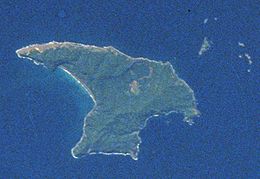
Anvil-shaped Raoul Island , the largest and northernmost of the main Kermadec Islands, , has been the source of vigorous volcanic activity during the past several thousand years that was dominated by dacitic explosive eruptions.The area of the island, including fringing islets and rocks...
Station, the northernmost outpost of New Zealand.
History
PolynesiaPolynesia
Polynesia is a subregion of Oceania, made up of over 1,000 islands scattered over the central and southern Pacific Ocean. The indigenous people who inhabit the islands of Polynesia are termed Polynesians and they share many similar traits including language, culture and beliefs...
n people settled the Kermadec Islands in around the 14th century (and perhaps previously in the 10th century), but when Europeans reached the area in 1788 they found no inhabitants. The islands were named for the French
France
The French Republic , The French Republic , The French Republic , (commonly known as France , is a unitary semi-presidential republic in Western Europe with several overseas territories and islands located on other continents and in the Indian, Pacific, and Atlantic oceans. Metropolitan France...
captain Jean-Michel Huon de Kermadec
Jean-Michel Huon de Kermadec
Jean-Michel Huon de Kermadec was an 18th century French navigator. In September 1791 he was chosen to command the Espérance on the Bruni d'Entrecasteaux expedition to find the lost expedition of Jean-François de La Pérouse. The expedition explored Australia and the South Pacific...
, who visited the islands as part of the d'Entrecasteaux expedition in the 1790s. European settlers, initially the Bell family, lived on the islands from the early nineteenth century until 1937, as did whalers. One of the Bell daughters, Elsie K. Morton, recounted the family's experience there in her memoir, Crusoes of Sunday Island.
Raoul Island Station
The Station comprises a government meteorologicalMeteorology
Meteorology is the interdisciplinary scientific study of the atmosphere. Studies in the field stretch back millennia, though significant progress in meteorology did not occur until the 18th century. The 19th century saw breakthroughs occur after observing networks developed across several countries...
and radio station, and a hostel for Department of Conservation officers and volunteers, that has been maintained since 1937. It lies on the northern terraces of Raoul Island, at an elevation of about 50 m (164 ft), above the cliffs of Fleetwood Bluff. It is the northernmost inhabited outpost of New Zealand.
Geography
The islands lie within 29° to 31.5° south latitude and 178° to 179° west longitude, 800–1000 km (497.1–621.4 mi) northeast of New Zealand's North IslandNorth Island
The North Island is one of the two main islands of New Zealand, separated from the much less populous South Island by Cook Strait. The island is in area, making it the world's 14th-largest island...
, and a similar distance southwest of Tonga
Tonga
Tonga, officially the Kingdom of Tonga , is a state and an archipelago in the South Pacific Ocean, comprising 176 islands scattered over of ocean in the South Pacific...
. The centre of the Kermadec Islands group is located at approximately 29°16′37"S 177°55′24"W. The total area of the islands is 33.08 km² (12.77 sq mi).
Climate
The climate of the islands is subtropical, with a mean monthly temperature of 22.4 °C (72.3 °F) in February and 16 °C (60.8 °F) in August. Rainfall is approximately 1500 mm (59.1 in) annually, with lower rainfall from October through January.The islands
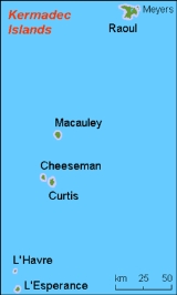
The group includes four main islands (three of them might be considered island groups, because the respective main islands have smaller islands close by) and some isolated rocks, which are, from north to south:- Raoul IslandRaoul IslandAnvil-shaped Raoul Island , the largest and northernmost of the main Kermadec Islands, , has been the source of vigorous volcanic activity during the past several thousand years that was dominated by dacitic explosive eruptions.The area of the island, including fringing islets and rocks...
or Sunday Island is by far the largest of the islands. It is located at 29°16′0"S 177°55′10"W, 900 km (559.2 mi) south-southwest of 'Ata'AtaAta is a small, rocky island in the far south of the Tonga archipelago, situated on . It is also known as Pylstaart island. It should not be confused with Atā, which is an uninhabited, low coral island in the string of small atolls along the Piha passage along the northside of Tongatapu, nor should...
, the southernmost island of Tonga, and 1100 km (683.5 mi) north-northeast of New Zealand. Raoul Island has an area of 29.38 km² (11.34 sq mi) with numerous smaller satellite islands, Moumoukai peak, 516 m (1,692.9 ft) high - Macauley IslandMacauley IslandMacauley Island is a volcanic island in New Zealand's Kermadec Islands, approximately halfway between New Zealand's North Island and Tonga in the southwest Pacific Ocean....
, the second largest, is located at 30°14′S 178°26′W, 110 km (68.4 mi) south-southeast of Raoul Island, Mount Haszard with an elevation of 238 m (780.8 ft), area 3.06 km² (1.2 sq mi) with neighboring island: Haszard Island.- Macdonald Rock is about 4 km (2.5 mi) north of Macauley Island at 30°11′S 178°26′W.
- Curtis Island, the third largest, is located at 30°32′32"S 178°33′39"W, 35 km (22 mi) south-southeast of Macauley Island, 137 m (449.5 ft) high, area 0.59 km² (0.227800273569596 sq mi) with neighbouring Cheeseman IslandCheeseman IslandCheeseman Island is a rocky volcanic island in the southwest Pacific Ocean . It is named after T. F. Cheeseman of the Auckland Museum - who was on board the NZ Government steamer 'Stella' when it visited the island in 1887. It neighbours Curtis Island to the east and lies about south of Macauley...
. - Nugent IslandNugent IslandNugent Island is the most northerly island in the Kermadec Islands and the most northerly territory in New Zealand. It lies to the northeast of New Zealand. It is circular and approximately across....
is the northernmost island. It is located at 29°13′54"S 177°52′09"W. It is approximately 100 metres (109 yd) across. - L'Esperance RockL'Esperance RockL'Esperance Rock, formerly French Rock, is the southernmost islet in the Kermadec Islands, to the north of New Zealand. It is south of Curtis Island and northeast of East Cape on New Zealand's North Island at . The smaller L'Havre Rock lies to the north-west of L'Esperance; it is a reef that...
, formerly French Rock, is 80 km (49.7 mi) south-southeast of Curtis Island at 31°26′S 178°54′W, 250 m (820.2 ft) in diameter, 0.05 km² (0.0193051079296268 sq mi) in area, 70 m (229.7 ft) high.- L'Havre Rock, about 8 km (5 mi) north-northwest of L'Esperance Rock near 31°21′S 178°59′W (submerged, barely above water during low tide)
Seamount
Seamount
A seamount is a mountain rising from the ocean seafloor that does not reach to the water's surface , and thus is not an island. These are typically formed from extinct volcanoes, that rise abruptly and are usually found rising from a seafloor of depth. They are defined by oceanographers as...
s north and south of the Kermadec Islands are an extension of the ridge running from Tonga to New Zealand (see Geology).
- Star of Bengal Bank, 103 km (64 mi) south-southwest of L'Esperance Rock, with a least depth of 48 metres (157.5 ft)
Geology
.jpg)
Volcano
2. Bedrock3. Conduit 4. Base5. Sill6. Dike7. Layers of ash emitted by the volcano8. Flank| 9. Layers of lava emitted by the volcano10. Throat11. Parasitic cone12. Lava flow13. Vent14. Crater15...
island arc
Island arc
An island arc is a type of archipelago composed of a chain of volcanoes which alignment is arc-shaped, and which are situated parallel and close to a boundary between two converging tectonic plates....
, formed at the convergent boundary
Convergent boundary
In plate tectonics, a convergent boundary, also known as a destructive plate boundary , is an actively deforming region where two tectonic plates or fragments of lithosphere move toward one another and collide...
where the Pacific Plate
Pacific Plate
The Pacific Plate is an oceanic tectonic plate that lies beneath the Pacific Ocean. At 103 million square kilometres, it is the largest tectonic plate....
subducts under the Indo-Australian Plate
Indo-Australian Plate
The Indo-Australian Plate is a major tectonic plate that includes the continent of Australia and surrounding ocean, and extends northwest to include the Indian subcontinent and adjacent waters...
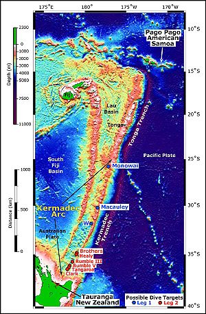
. The subducting Pacific Plate created the Kermadec Trench
Kermadec Trench
The Kermadec trench is one of Earth's deepest oceanic trenches, reaching a depth of . Formed by the subduction of the Pacific Plate under the Indo-Australian Plate, it runs over a thousand kilometres parallel with and to the east of the Kermadec Ridge and island arc, from near the northeastern tip...
, an 8 km deep submarine trench, to the east of the islands. The islands lie along the undersea Kermadec Ridge, which runs southwest from the islands towards the North Island
North Island
The North Island is one of the two main islands of New Zealand, separated from the much less populous South Island by Cook Strait. The island is in area, making it the world's 14th-largest island...
of New Zealand
New Zealand
New Zealand is an island country in the south-western Pacific Ocean comprising two main landmasses and numerous smaller islands. The country is situated some east of Australia across the Tasman Sea, and roughly south of the Pacific island nations of New Caledonia, Fiji, and Tonga...
and northeast towards Tonga
Tonga
Tonga, officially the Kingdom of Tonga , is a state and an archipelago in the South Pacific Ocean, comprising 176 islands scattered over of ocean in the South Pacific...
(Kermadec-Tonga Arc).
The four main islands are the peaks of volcanoes that rise high enough from the seabed to project above sea level. There are several other volcanoes in the chain that do not reach sea level, but form seamount
Seamount
A seamount is a mountain rising from the ocean seafloor that does not reach to the water's surface , and thus is not an island. These are typically formed from extinct volcanoes, that rise abruptly and are usually found rising from a seafloor of depth. They are defined by oceanographers as...
s with between 65 and 1500 m of water above their peaks. Monowai Seamount
Monowai Seamount
Monowai is a volcanic seamount to the north of New Zealand. It is one of the most active volcanoes in the Kermadec volcanic arc.The most recent eruption was in 2008....
, with a depth of 120 m over its peak, is midway between Raoul Island and Tonga. 100 km south of L'Esperance Rock is the little-explored Star of Bengal Bank, probably with submarine volcanoes.
Further south are the South Kermadec Ridge Seamounts, the southernmost of which, Rumble IV Seamount, is just 150 km North of the North Island of New Zealand. The ridge eventually connects to White Island
Whakaari/White Island
Whakaari/White Island is an active andesite stratovolcano, situated from the east coast of the North Island of New Zealand, in the Bay of Plenty. The nearest mainland towns are Whakatane and Tauranga....
in New Zealand's Bay of Plenty
Bay of Plenty
The Bay of Plenty , often abbreviated to BOP, is a region in the North Island of New Zealand situated around the body of water of the same name...
, at the northern end of the Taupo Volcanic Zone
Taupo Volcanic Zone
The Taupo Volcanic Zone is a highly active volcanic V shaped area in the North Island of New Zealand that is spreading east -west at the rate of about 8mm per year...
. The islands experience many earthquake
Earthquake
An earthquake is the result of a sudden release of energy in the Earth's crust that creates seismic waves. The seismicity, seismism or seismic activity of an area refers to the frequency, type and size of earthquakes experienced over a period of time...
s from plate movement and volcanism.
Raoul and Curtis are both active volcano
Volcano
2. Bedrock3. Conduit 4. Base5. Sill6. Dike7. Layers of ash emitted by the volcano8. Flank| 9. Layers of lava emitted by the volcano10. Throat11. Parasitic cone12. Lava flow13. Vent14. Crater15...
es. The volcanoes on the other islands are currently inactive, and the smaller islands are the eroded remnants of extinct volcanoes.
On 6 July 2011 (2pm CDT, GMT-5), a large earthquake provisionally measuring 7.6 on the Richter Scale was reported, centered near the Kermadec Islands, 211 km east of Raoul Island.
On 20 October 2011 a 7.3 earthquake on the Richter Scale was reported, centered near the Kermadec Islands, 112 miles east of Raoul Island. No immediate tsunami threat was reported.
On 21 October 2011 a 7.4 earthquake on the Richter Scale was reported near the Kermadec Islands,
169 km (105 miles) E of Raoul Island at 17:57:16 UTC at epicenter.
Environment
The islands are recognized by ecologists as a distinct ecoregionEcoregion
An ecoregion , sometimes called a bioregion, is an ecologically and geographically defined area that is smaller than an ecozone and larger than an ecosystem. Ecoregions cover relatively large areas of land or water, and contain characteristic, geographically distinct assemblages of natural...
, the Kermadec Islands subtropical moist forests. They are a tropical and subtropical moist broadleaf forests
Tropical and subtropical moist broadleaf forests
Tropical and subtropical moist broadleaf forests , also known as tropical moist forests, are a tropical and subtropical forest biome....
ecoregion, part of the Oceania ecozone
Oceania ecozone
Oceania is one of the WWF ecozones, and unique in not including any continental land mass. The ecozone includes the Pacific Ocean islands of Micronesia, the Fijian Islands, and most of Polynesia...
. The forests are dominated by the red-flowering Kermadec Pōhutukawa
Metrosideros kermadecensis
Metrosideros kermadecensis, commonly called the is an evergreen tree of the myrtle family which is endemic to the volcanic Kermadec Islands about 900 km north-east of New Zealand. The tree produces a brilliant display of red flowers, made up of a mass of stamens and is the dominant forest tree on...
, related to the Pōhutukawa of New Zealand. The islands have no native land mammals, but were home to large colonies of seabird
Seabird
Seabirds are birds that have adapted to life within the marine environment. While seabirds vary greatly in lifestyle, behaviour and physiology, they often exhibit striking convergent evolution, as the same environmental problems and feeding niches have resulted in similar adaptations...
s which nested among the forests.
Flora and fauna
The Kermadec Islands are home to 113 native species of vascular plantVascular plant
Vascular plants are those plants that have lignified tissues for conducting water, minerals, and photosynthetic products through the plant. Vascular plants include the clubmosses, Equisetum, ferns, gymnosperms and angiosperms...
s, of which 23 are endemic
Endemic (ecology)
Endemism is the ecological state of being unique to a defined geographic location, such as an island, nation or other defined zone, or habitat type; organisms that are indigenous to a place are not endemic to it if they are also found elsewhere. For example, all species of lemur are endemic to the...
, along with mosses (52 native species), lichens and fungi (89 native species). Most of the plant species are derived from New Zealand, with others from the tropical Pacific. 152 non-native species of plants introduced by humans have become established on the islands.
Dense subtropical forests cover most of Raoul, and formerly covered Macauley. Metrosideros kermadecensis
Metrosideros kermadecensis
Metrosideros kermadecensis, commonly called the is an evergreen tree of the myrtle family which is endemic to the volcanic Kermadec Islands about 900 km north-east of New Zealand. The tree produces a brilliant display of red flowers, made up of a mass of stamens and is the dominant forest tree on...
is the dominant forest tree, forming a 10 – 15 meter high canopy. A native Nikau Palm (Rhopalostylis baueri
Rhopalostylis baueri
Rhopalostylis baueri is a species of palm native to Norfolk Island and to the Kermadec Islands . Norfolk Island is the type locality. The common names on Norfolk Island are 'Norfolk Island Palm' or 'Niau'...
) is another important canopy tree. The forests had a rich understory of smaller trees, shrubs, ferns, and herbs, including Myrsine kermadecensis
Matipó
Matipó is a Brazilian municipality located in the state of Minas Gerais. The city belongs to the mesoregion of Zona da Mata and to the microregion of Manhuaçu.-See also:* List of municipalities in Minas Gerais-References:...
; Lobelia
Lobelia
Lobelia is a genus of flowering plant comprising 360–400 species, with a subcosmopolitan distribution primarily in tropical to warm temperate regions of the world, a few species extending into cooler temperate regions...
anceps, Poa
Poa
Poa is a genus of about 500 species of grasses, native to the temperate regions of both hemispheres. Common names include meadow-grass , bluegrass , tussock , and speargrass. "Poa" is Greek for fodder...
polyphylla, Coprosma
Coprosma
Coprosma is a genus of 108 species that are found in New Zealand , Hawaii , Borneo, Java, New Guinea, islands of the Pacific Ocean to Australia and the Juan Fernández Is. Many species are small shrubs with tiny evergreen leaves, but a few are small trees and have much larger leaves...
acutifolia, and Coriaria
Coriaria
Coriaria is the sole genus in the family Coriariaceae. It includes about 30 species of subshrubs, shrubs and small trees, with a widespread but disjunct distribution across warm temperate regions of the world, occurring as far apart as the Mediterranean region, southern and eastern Asia, New...
arborea. Two endemic tree ferns, Cyathea milnei and the rare and endangered Cyathea kermadecensis
Cyathea kermadecensis
Cyathea kermadecensis is a species of tree fern endemic to Raoul Island in the Kermadec Islands, where it is locally common in damp, and sometimes drier, forest and scrub. The trunk of this plant is erect, slender, and up to 20 m tall. It is often covered with scars of old stipe-bases. Fronds are...
, are also found in the forests.
Areas near the seashore and exposed to salt spray are covered by a distinct community of shrubs and ferns, notably Myosporum obscurum, Coprosma petiolata, Asplenium
Asplenium
Asplenium is a genus of about 700 species of ferns, often treated as the only genus in the family Aspleniaceae, though other authors consider Hymenasplenium separate, based on molecular phylogenetic analysis of DNA sequences, a different chromosome count, and structural differences in the rhizomes...
obtusatum, Cyperus
Cyperus
Cyperus is a large genus of about 600 species of sedges, distributed throughout all continents in both tropical and temperate regions. They are annual or perennial plants, mostly aquatic and growing in still or slow-moving water up to 0.5 m deep. The species vary greatly in size, with small species...
ustulatus, Disphyma
Disphyma
Disphyma is a monotypic genus of succulent shrubs. Commonly known as Round-leaved Pigface, it occurs in South Africa, Australia and New Zealand. Its sole species, Disphyma crassifolium, is divided into two subspecies, D. crassifolium subsp. crassifolium and D. crassifolium subsp...
australe, and Scirpus nodosus.
An endemic bird subspecies is the Kermadec Red-crowned Parakeet
Kermadec Red-crowned Parakeet
The Kermadec Red-crowned Parakeet , also known as the Kermadec Red-fronted Parakeet or Kermadec Parakeet, is a parrot endemic to New Zealand's Kermadec Islands in the south-west Pacific Ocean. It is a subspecies of the Red-fronted Parakeet, and sometimes considered a full species...
.
Conservation
The Introduction of catCat
The cat , also known as the domestic cat or housecat to distinguish it from other felids and felines, is a small, usually furry, domesticated, carnivorous mammal that is valued by humans for its companionship and for its ability to hunt vermin and household pests...
s, rat
Rat
Rats are various medium-sized, long-tailed rodents of the superfamily Muroidea. "True rats" are members of the genus Rattus, the most important of which to humans are the black rat, Rattus rattus, and the brown rat, Rattus norvegicus...
s, and goat
Goat
The domestic goat is a subspecies of goat domesticated from the wild goat of southwest Asia and Eastern Europe. The goat is a member of the Bovidae family and is closely related to the sheep as both are in the goat-antelope subfamily Caprinae. There are over three hundred distinct breeds of...
s devastated the forests and seabirds. Overgrazing by goats eliminated the forests of Macauley Island, leaving open grasslands, and altered the understory of Raoul Island. Predation by rats and cats reduced the seabird colonies on the main islands from millions of birds to tens of thousands. The New Zealand government has been working for the last few decades to restore the islands. New Zealand declared the islands a nature reserve
Nature reserve
A nature reserve is a protected area of importance for wildlife, flora, fauna or features of geological or other special interest, which is reserved and managed for conservation and to provide special opportunities for study or research...
in 1937, and the sea around them a marine reserve
Marine reserves of New Zealand
New Zealand has over thirty marine reserves spread around the North, the South Island, and neighbouring islands, and another two on outlying island groups...
in 1990. Goats were removed from Macauley in 1970 and from Raoul in 1984, and the forests have begun to recover. The islands are still known for their bird life, and seabird colonies presently inhabit offshore islets, which are safe from introduced rats and cats. Efforts are currently underway to remove the rats and cats from the islands, as well as some of the invasive exotic plants.
Visits to the islands are restricted by the Department of Conservation. The Department allows visits to Raoul by volunteers assisting in environmental restoration or monitoring projects, and other visitors engaged in nature study. Visits to the other islands are generally restricted to those engaged in scientific study of the islands.
Recent efforts by the Department of Conservation staff have resulted in eradicating all the known pests that have built up over the years resulting in a flush of growth of new seedlings of the once near endangered species of native plants.
External links
- Kermadec Islands subtropical moist forests at the World Wildlife Fund
- Kermadec Marine Reserve at the New Zealand Department of Conservation
- Kermadec Islands Marine Reserve at Seafriends