

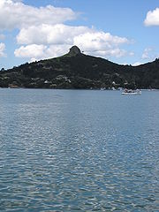
Whangaroa Harbour
Encyclopedia

New Zealand
New Zealand is an island country in the south-western Pacific Ocean comprising two main landmasses and numerous smaller islands. The country is situated some east of Australia across the Tasman Sea, and roughly south of the Pacific island nations of New Caledonia, Fiji, and Tonga...
. Whangaroa Bay and the Pacific Ocean are to the north. The small settlements of Totara North and Saies are on the west side of the harbour, Waitaruke on the south side, and Whangaroa
Whangaroa
Whangaroa is a locality on the harbour of the same name in Northland, New Zealand.Whangaroa is 8km north-west from Kaeo and 45km north from Okaihau. The harbour is almost landlocked and is popular both as a fishing spot in its own right and as a base for deep-sea fishing.The harbour was the scene...
on the east. State Highway 10 runs through Waitaruke. The name comes from the lament "Whaingaroa" or "what a long wait" of a woman whose warrior husband had left for a foray to the south. The harbour was formed when rising sea levels drowned a river valley about 6,000 years ago. Steep outcrops remain from ancient volcanic rocks.
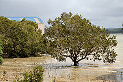
There are extensive mangrove
Mangrove
Mangroves are various kinds of trees up to medium height and shrubs that grow in saline coastal sediment habitats in the tropics and subtropics – mainly between latitudes N and S...
swamps at the head of the harbour, and some of the oldest fossils in the North Island, dating to the early Permian
Permian
The PermianThe term "Permian" was introduced into geology in 1841 by Sir Sir R. I. Murchison, president of the Geological Society of London, who identified typical strata in extensive Russian explorations undertaken with Edouard de Verneuil; Murchison asserted in 1841 that he named his "Permian...
about 270 million years ago, are in the Whangaroa area.
History
According to Māori traditions, the wakaWaka (canoe)
Waka are Māori watercraft, usually canoes ranging in size from small, unornamented canoes used for fishing and river travel, to large decorated war canoes up to long...
Māhuhu-ki-te-rangi
Mahuhu-ki-te-rangi
In Māori tradition, Māhuhu-ki-te-rangi was one of the great ocean-going, voyaging canoes that was used in the migrations that settled New Zealand....
explored the Whangaroa harbour during early Māori settlement
Maori migration canoes
Various Māori traditions recount how their ancestors set out from their homeland in great ocean-going canoes . Some of these traditions name a mythical homeland called Hawaiki....
of New Zealand. The area was settled by descendants of Te Māmaru and Mataatua
Mataatua
In Māori tradition, Mataatua was one of the great voyaging canoes by which Polynesians migrated to New Zealand. Māori traditions say that the Mataatua was initially sent from Hawaiki to bring supplies of kūmara to Māori settlements in New Zealand...
waka crews.
Whaling
Whaling
Whaling is the hunting of whales mainly for meat and oil. Its earliest forms date to at least 3000 BC. Various coastal communities have long histories of sustenance whaling and harvesting beached whales...
and other ships visited Whangaroa from 1805 to 1809, including the General Wellesley and Commerce in 1806, and Elizabeth in 1809. Sixty-six members of the crew of the Boyd
Boyd massacre
The Boyd Massacre took place in 1809 when Māori residents of Whangaroa Harbour in northern New Zealand killed and ate between 66 and 70 people as revenge for the whipping of a young Māori chief by the crew of the sailing ship Boyd...
were killed by local Māori in 1809 after the crew whipped the son of a chief. The visits ceased as a result, resuming when the Dromedary loaded timber in 1819.
A Wesleyan mission was founded in June 1823. Hongi Hika
Hongi Hika
Hongi Hika was a New Zealand Māori rangatira and war leader of the Ngāpuhi iwi . Hongi Hika used European weapons to overrun much of northern New Zealand in the first of the Musket Wars...
attacked local Māori to gain control of millable kauri on 10 January 1827. Although he did not attack the mission, its inhabitants took fright and it was abandoned. In 1828 Hongi Hika died at Whangaroa, from a wound suffered 14 months earlier in the Hokianga
Hokianga
Hokianga is an area surrounding the Hokianga Harbour, also known as The Hokianga River, a long estuarine drowned valley on the west coast in the north of the North Island of New Zealand....
.
Europeans settled the harbour in the 1840s, and a Catholic mission was established at Waitaruke. The harbour was a centre for timber milling and gum digging after the arrival of the immigrant ship Lancashire Witch in 1865. Shipyards were established in Totara North in 1872. Kauri
Agathis australis
Agathis australis, commonly known as the kauri, is a coniferous tree found north of 38°S in the northern districts of New Zealand's North Island. It is the largest but not tallest species of tree in New Zealand, standing up to 50 m tall in the emergent layer above the forest's main canopy. The...
logs were chained together to make rafts, and towed by steamer. It took three days for the logs to reach Auckland
Auckland
The Auckland metropolitan area , in the North Island of New Zealand, is the largest and most populous urban area in the country with residents, percent of the country's population. Auckland also has the largest Polynesian population of any city in the world...
. In the early 20th century Sea Sick Bay near the south head was a whaling station, which by the 1920s had moved to Ranfurly Bay, near the north head.
After the Mangamuka Gorge road was sealed in 1961 it became the main route from Whangarei to the Far North, bypassing Whangaroa.
Education
Te Kura o Hato Hohepa Te Kamura is a full primary (years 1-8) school in Waitaruke. It has a decile ratingSocio-Economic Decile
Decile, Socio-Economic Decile or Socio-Economic Decile Band is a widely used measure in education in New Zealand used to target funding and support to more needy schools....
of 1 and a roll of 18.
Totara North School is a contributing primary (years 1-6) school with a decile rating of 3 and a roll of 39.
Both schools are coeducational. Other schools in the area are at Oruaiti
Oruaiti
Oruaiti is a locality in Northland, New Zealand. It lies on Highway 10. Mangonui lies to the west, and Whangaroa Harbour to the east.-Education:...
, Kaeo
Kaeo
The township of Kaeo lies some 22 km northwest of Kerikeri in Northland, New Zealand. The town takes its name from the unique shellfish found in the nearby Whangaroa Harbour....
and Matauri Bay
Matauri Bay
Matauri Bay is a bay in New Zealand, situated 30 km north of Kerikeri, in Whangaroa county, just north of the Bay of Islands. It has over a kilometre of beautiful white sand and crystal clear water...
.