
Mount St. Helens
Overview
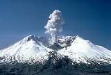
Stratovolcano
A stratovolcano, also known as a composite volcano, is a tall, conical volcano built up by many layers of hardened lava, tephra, pumice, and volcanic ash. Unlike shield volcanoes, stratovolcanoes are characterized by a steep profile and periodic, explosive eruptions...
located in Skamania County, Washington, in the Pacific Northwest
Pacific Northwest
The Pacific Northwest is a region in northwestern North America, bounded by the Pacific Ocean to the west and, loosely, by the Rocky Mountains on the east. Definitions of the region vary and there is no commonly agreed upon boundary, even among Pacific Northwesterners. A common concept of the...
region of the United States
United States
The United States of America is a federal constitutional republic comprising fifty states and a federal district...
. It is 96 miles (154.5 km) south of Seattle, Washington and 50 miles (80.5 km) northeast of Portland, Oregon
Portland, Oregon
Portland is a city located in the Pacific Northwest, near the confluence of the Willamette and Columbia rivers in the U.S. state of Oregon. As of the 2010 Census, it had a population of 583,776, making it the 29th most populous city in the United States...
. Mount St. Helens takes its English name from the British
United Kingdom
The United Kingdom of Great Britain and Northern IrelandIn the United Kingdom and Dependencies, other languages have been officially recognised as legitimate autochthonous languages under the European Charter for Regional or Minority Languages...
diplomat Lord St Helens
Alleyne Fitzherbert, 1st Baron St Helens
Alleyne FitzHerbert, 1st Baron St Helens PC was a British diplomat and a friend of explorer George Vancouver, who named Mount St...
, a friend of explorer George Vancouver
George Vancouver
Captain George Vancouver RN was an English officer of the British Royal Navy, best known for his 1791-95 expedition, which explored and charted North America's northwestern Pacific Coast regions, including the coasts of contemporary Alaska, British Columbia, Washington and Oregon...
who made a survey of the area in the late 18th century.
Unanswered Questions