
.gif)
State Scenic Highway System (California)
Encyclopedia
The State Scenic Highway System is a list of highways, mainly state highway
s, that have been designated by the California Department of Transportation
(Caltrans) as scenic highways. The California State Legislature
, primarily through Section 263 of the Streets and Highways Code, makes highways eligible for designation as a scenic highway. For a highway to be declared scenic, the government with jurisdiction over abutting land must adopt a "scenic corridor protection program" that limits development, outdoor advertising, and earthmoving, and Caltrans must agree that it meets the criteria. The desire to create such a designation has at times been in conflict with the property rights of abutters, for example on State Route 174
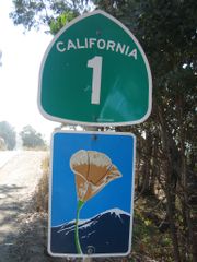
. Scenic highways are marked by the state flower, a California poppy
, inside a rectangle (for state highways) or pentagon (for county highway
s).
 State Route 1
State Route 2
State Route 3
State Route 4
Interstate 5
Interstate 8
State Route 9
Interstate 10
State Route 12
State Route 13
State Route 14
Interstate 15
State Route 16
State Route 17
State Route 18
State Route 20
State Route 24
State Route 25
State Route 27
State Route 28
State Route 29
State Route 33
State Route 35
State Route 36
State Route 37 (partly unconstructed)
State Route 38
State Route 39
Interstate 40
State Route 41
State Route 44
State Route 46
State Route 49
U.S. Route 50
State Route 52
State Route 53
State Route 57
State Route 58
State Route 62
State Route 68
State Route 70
State Route 71
State Route 74 (partly unconstructed)
State Route 75
State Route 76
State Route 78
State Route 79
Interstate 80
State Route 84
State Route 88
State Route 89
State Route 91
State Route 92
State Route 94
State Route 96
U.S. Route 97
U.S. Route 101
State Route 108
State Route 110
State Route 111
State Route 116
State Route 118
State Route 120
State Route 121
State Route 125
State Route 126
State Route 127
State Route 138
State Route 139
State Route 140
State Route 142
State Route 146
State Route 150
State Route 151
State Route 152
State Route 154
State Route 156
State Route 158
State Route 160
State Route 161
State Route 163
State Route 166
State Route 168
State Route 173
State Route 174
State Route 178
State Route 180
State Route 190 (partly unconstructed)
State Route 197
State Route 198
U.S. Route 199
State Route 203
State Route 209 (relinquished)
Interstate 210
/State Route 210
State Route 221
State Route 236
State Route 239 (unconstructed)
State Route 243
State Route 247
State Route 251 (unconstructed)
State Route 254
State Route 266
Interstate 280
(partly unconstructed)
State Route 299
State Route 330
U.S. Route 395
Interstate 580
Interstate 680
County Route G14
County Route G20
County Route N1
Mulholland Highway
River Road
State highway
State highway, state road or state route can refer to one of three related concepts, two of them related to a state or provincial government in a country that is divided into states or provinces :#A...
s, that have been designated by the California Department of Transportation
California Department of Transportation
The California Department of Transportation is a government department in the U.S. state of California. Its mission is to improve mobility across the state. It manages the state highway system and is actively involved with public transportation systems throughout the state...
(Caltrans) as scenic highways. The California State Legislature
California State Legislature
The California State Legislature is the state legislature of the U.S. state of California. It is a bicameral body consisting of the lower house, the California State Assembly, with 80 members, and the upper house, the California State Senate, with 40 members...
, primarily through Section 263 of the Streets and Highways Code, makes highways eligible for designation as a scenic highway. For a highway to be declared scenic, the government with jurisdiction over abutting land must adopt a "scenic corridor protection program" that limits development, outdoor advertising, and earthmoving, and Caltrans must agree that it meets the criteria. The desire to create such a designation has at times been in conflict with the property rights of abutters, for example on State Route 174
State Route 174 (California)
State Route 174 is a state highway in the U.S. state of California. The two-lane 13-mile highway, added to the state highway system in 1933, connects Interstate 80 in Colfax with SR 20/SR 49 in Grass Valley, crossing the Bear River next to a 1924 concrete arch bridge...
. Scenic highways are marked by the state flower, a California poppy
California poppy
The California poppy is a perennial and annual plant, native to the United States, and the official state flower of California.- Description :...
, inside a rectangle (for state highways) or pentagon (for county highway
County highway
A county highway is a road in the United States and in the Canadian province of Ontario that is designated and/or maintained by the county highway department...
s).
List of eligible and designated scenic highways
- I-5 in San Juan CapistranoSan Juan Capistrano, CaliforniaSan Juan Capistrano is a city in southern Orange County, California, located approximately southeast of Downtown Santa Ana. The current OMB metropolitan designation for San Juan Capistrano and the Orange County Area is “Santa Ana-Anaheim-Irvine, CA.” The population was 34,593 at the 2010 census,...
to SR 19 in Long BeachLong Beach, CaliforniaLong Beach is a city situated in Los Angeles County in Southern California, on the Pacific coast of the United States. The city is the 36th-largest city in the nation and the seventh-largest in California. As of 2010, its population was 462,257... - SR 187 near Santa MonicaSanta Monica, CaliforniaSanta Monica is a beachfront city in western Los Angeles County, California, US. Situated on Santa Monica Bay, it is surrounded on three sides by the city of Los Angeles — Pacific Palisades on the northwest, Brentwood on the north, West Los Angeles on the northeast, Mar Vista on the east, and...
to US 101 near El RioEl Rio, CaliforniaEl Rio is a small unincorporated census-designated town in Ventura County, California, USA, on the northeast side of the 101 Freeway and Oxnard, and south of the Santa Clara River... - US 101 at Las CrucesLas Cruces, CaliforniaLas Cruces, California is an unincorporated community in Santa Barbara County, California. It lies at the split between California State Route 1, which travels north to Lompoc, and U.S. Route 101, which travels north to Buellton. The community lies within area code 805.-References:...
to SR 246California State Route 246State Route 246 is a state highway in the U.S. state of California. It runs from Lompoc to Santa Ynez and cuts through the Santa Barbara Wine Country.-Route description:...
in LompocLompoc, CaliforniaLompoc is a city in Santa Barbara County, California, United States. The city was incorporated in 1888. The population was 42,434 at the 2010 census, up from 41,103 at the 2000 census....
- Designated 1971-12-14 in Santa Barbara CountySanta Barbara County, CaliforniaSanta Barbara County is a county located in the southern portion of the U.S. state of California, on the Pacific coast. As of 2010 the county had a population of 423,895. The county seat is Santa Barbara and the largest city is Santa Maria.-History:...
: US 101 at Las CrucesLas Cruces, CaliforniaLas Cruces, California is an unincorporated community in Santa Barbara County, California. It lies at the split between California State Route 1, which travels north to Lompoc, and U.S. Route 101, which travels north to Buellton. The community lies within area code 805.-References:...
to LompocLompoc, CaliforniaLompoc is a city in Santa Barbara County, California, United States. The city was incorporated in 1888. The population was 42,434 at the 2010 census, up from 41,103 at the 2000 census....
- Designated 1971-12-14 in Santa Barbara County
- SR 227 (unconstructed) near OceanoOceano, CaliforniaOceano is a census-designated place in San Luis Obispo County, California, United States. The population was 7,286 at the 2010 census, up from 7,260 at the 2000 census.-Geography:Oceano is located at ....
to US 101 in Pismo BeachPismo Beach, CaliforniaPismo Beach is a city in San Luis Obispo County, California, United States. The population was 7,655 at the 2010 census, down from 8,551 at the 2000 census... - US 101 in San Luis ObispoSan Luis Obispo, CaliforniaSan Luis Obispo is a city in California, located roughly midway between San Francisco and Los Angeles on the Central Coast. Founded in 1772 by Spanish Fr. Junipero Serra, San Luis Obispo is one of California’s oldest communities...
to SR 35 in Daly CityDaly City, CaliforniaDaly City is the largest city in San Mateo County, California, United States, with a 2010 population of 101,123. Located immediately south of San Francisco, it is named in honor of businessman and landowner John Daly.-History:...
- Designated 1999-08-13 in San Luis Obispo CountySan Luis Obispo County, CaliforniaSan Luis Obispo County is a county located along the Pacific Ocean in the Central Coast of the U.S. state of California, between Los Angeles and the San Francisco Bay Area. As of the 2010 census its population was 269,637, up from 246,681 at the 2000 census...
: San Luis Obispo to Monterey CountyMonterey County, CaliforniaMonterey County is a county located on the Pacific coast of the U.S. state of California, its northwestern section forming the southern half of Monterey Bay. The northern half of the bay is in Santa Cruz County. As of 2010, the population was 415,057. The county seat and largest city is Salinas... - Designated 1965-06-07 in Monterey CountyMonterey County, CaliforniaMonterey County is a county located on the Pacific coast of the U.S. state of California, its northwestern section forming the southern half of Monterey Bay. The northern half of the bay is in Santa Cruz County. As of 2010, the population was 415,057. The county seat and largest city is Salinas...
: San Luis Obispo County to Carmel RiverCarmel RiverThe Carmel River is a river on the Central Coast of California in Monterey County that originates in the Santa Lucia Mountains. The river flows northwest through the Carmel Valley with its mouth at the Pacific Ocean south of Carmel-by-the-Sea. It is often considered the northern boundary of Big Sur... - Designated 1970-05-21 in Monterey CountyMonterey County, CaliforniaMonterey County is a county located on the Pacific coast of the U.S. state of California, its northwestern section forming the southern half of Monterey Bay. The northern half of the bay is in Santa Cruz County. As of 2010, the population was 415,057. The county seat and largest city is Salinas...
: Carmel RiverCarmel RiverThe Carmel River is a river on the Central Coast of California in Monterey County that originates in the Santa Lucia Mountains. The river flows northwest through the Carmel Valley with its mouth at the Pacific Ocean south of Carmel-by-the-Sea. It is often considered the northern boundary of Big Sur...
to SR 68 in MontereyMonterey, CaliforniaThe City of Monterey in Monterey County is located on Monterey Bay along the Pacific coast in Central California. Monterey lies at an elevation of 26 feet above sea level. As of the 2010 census, the city population was 27,810. Monterey is of historical importance because it was the capital of... - Designated 1976-06-25 in San Mateo CountySan Mateo County, CaliforniaSan Mateo County is a county located in the San Francisco Bay Area of the U.S. state of California. It covers most of the San Francisco Peninsula just south of San Francisco, and north of Santa Clara County. San Francisco International Airport is located at the northern end of the county, and...
: Santa Cruz County to Half Moon BayHalf Moon Bay, CaliforniaHalf Moon Bay is a coastal city in San Mateo County, California, USA. Its population was 11,324 as of the 2010 census. Immediately at the north of Half Moon Bay is the Pillar Point Harbor and the unincorporated community of Princeton-by-the-Sea....
- Designated 1999-08-13 in San Luis Obispo County
- SR 35 to US 101 in San Francisco
- US 101 near Marin CityMarin City, CaliforniaMarin City, is an unincorporated community and census-designated place in Marin County, California, United States. It is located northwest of downtown Sausalito, at an elevation of 23 feet . Marin City was developed for housing starting in 1942, to accommodate war-time shipyard workers and other...
to US 101 at LeggettLeggett, CaliforniaLeggett is a census-designated place in Mendocino County, California. It is located on the South Fork of the Eel River northwest of Laytonville, at an elevation of 984 feet . It is home to some of the largest trees in the world...
State Route 2
State Route 2 (California)
State Route 2 is a state highway in the U.S. state of California. It runs from the junction of Lincoln Blvd and Interstate 10 in Santa Monica to SR 138 east of Wrightwood, running concurrent with U.S...
- I-210 in La Cañada FlintridgeLa Cañada Flintridge, CaliforniaLa Cañada Flintridge is a small and affluent city in Los Angeles County, California, United States whose population at the 2010 census was 20,246, down from 20,318 at the 2000 census. According to Forbes, as of 2010, La Cañada Flintridge ranks as the 143rd most expensive U.S...
to SR 138California State Route 138State Route 138 is an east–west state highway generally following the northern foothills of the San Gabriel Mountains of southern California, USA from its junction with Interstate 5 south of Gorman eastward to Mount Anderson Junction, its eastern junction with State Route 18 south of...
near Wrightwood- Designated 1971-05-12 in Los Angeles County: La Cañada FlintridgeLa Cañada Flintridge, CaliforniaLa Cañada Flintridge is a small and affluent city in Los Angeles County, California, United States whose population at the 2010 census was 20,246, down from 20,318 at the 2000 census. According to Forbes, as of 2010, La Cañada Flintridge ranks as the 143rd most expensive U.S...
to San Bernardino County
- Designated 1971-05-12 in Los Angeles County: La Cañada Flintridge
State Route 3
State Route 3 (California)
State Route 3 is a state highway in the U.S. state of California. It runs from State Route 36 north along the shore of Trinity Lake, Fort Jones and Etna. The route approaches Yreka, intersecting with Interstate 5, and turns east to Montague...
- SR 36 near PeanutPeanut, CaliforniaPeanut is a tiny unincorporated community in Trinity County, California. It is located on Highway 3, south of Hayfork and north of Highway 36 at an elevation of 2499 feet....
to Montague
State Route 4
State Route 4 (California)
State Route 4 is a state highway in the U.S. state of California, routed from Interstate 80 in the San Francisco Bay Area to State Route 89 in the Sierra Nevada. It passes through Ebbetts Pass and contains the Ebbetts Pass Scenic Byway, a National Scenic Byway.SR 4 roughly parallels the...
- SR 160 in Antioch to unconstructed SR 84 near BrentwoodBrentwood, CaliforniaBrentwood is a city in Contra Costa County, California, United States. It is located in the East Bay region of the San Francisco Bay Area. The population is 51,481 as of 2010....
- SR 49 in Angels Camp to SR 89 near MarkleevilleMarkleeville, CaliforniaMarkleeville is a census-designated place and the county seat of Alpine County, California. The population was 210 at the 2010 census, up from 197 at the 2000 census.The CDP of Markleeville also includes Woodfords....
- Designated 1971-11-09 in Calaveras County: ArnoldArnold, CaliforniaArnold is a census-designated place in Calaveras County, California, United States. The population was 3,843 at the 2010 census, down from 4,218 at the 2000 census. Arnold is located on State Route 4.-History:...
to Alpine CountyAlpine County, CaliforniaAlpine County is the smallest county, by population, in the U.S. state of California. As of 2010, it had a population of 1,175, all rural. There are no incorporated cities in the county. The county seat is Markleeville... - Designated 1970-09-14 in Alpine County: Calaveras County to SR 89 near Markleeville
- Designated 1971-11-09 in Calaveras County: Arnold
Interstate 5
- MexicoMexicoThe United Mexican States , commonly known as Mexico , is a federal constitutional republic in North America. It is bordered on the north by the United States; on the south and west by the Pacific Ocean; on the southeast by Guatemala, Belize, and the Caribbean Sea; and on the east by the Gulf of...
to SR 75 in southern San Diego - SR 75 near Downtown San Diego to SR 74 in San Juan Capistrano
- I-210 in Sylmar to SR 126 in Santa Clarita
- SR 152 near Los Banos to I-580 near Tracy
- Designated 1968-10-25 in Merced County: SR 152 near Los Banos to Stanislaus County
- Designated 1968-10-25 in Stanislaus County: Merced County to San Joaquin County
- Designated 1974-06-07 in San Joaquin County: Stanislaus County to I-580 near Tracy
- SR 44 in Redding to Shasta LakeShasta LakeShasta Lake, also called Lake Shasta, is an artificial lake created by the construction of Shasta Dam across the Sacramento River in the Shasta-Trinity National Forest of Shasta County, California...
- SR 89 near Mount Shasta to US 97 in Weed
- SR 3 in Yreka to OregonOregonOregon is a state in the Pacific Northwest region of the United States. It is located on the Pacific coast, with Washington to the north, California to the south, Nevada on the southeast and Idaho to the east. The Columbia and Snake rivers delineate much of Oregon's northern and eastern...
Interstate 8
- Sunset Cliffs Boulevard in San Diego to SR 98 near Ocotillo
State Route 9
- SR 1 in Santa Cruz to SR 17 in Los Gatos
- Designated 1979-10-18 in Santa Clara County: SR 35 at Saratoga Gap to Saratoga Sunnyvale Road in Saratoga
- Designated 1968-05-02 in Santa Clara County: Saratoga Sunnyvale Road in Saratoga to Los Gatos
Interstate 10
- SR 38 in Redlands to SR 62 near White Water
State Route 12
State Route 12 (California)
State Route 12 is a state highway in the U.S. state of California that travels in an east–west direction from Sebastopol in Sonoma County to State Route 49 just north of San Andreas in Calaveras County...
- US 101 in Santa Rosa to SR 121 near Sonoma
- Designated 1974-12-17 in Sonoma County: Santa Rosa to Agua Caliente
State Route 13
State Route 13 (California)
State Route 13 is a state highway in California. It is a short loop in Alameda County currently built from Interstate 580 in Oakland to Interstate 80/Interstate 580 in Berkeley....
- I-580 to SR 24 in Oakland
State Route 14
- SR 58 near Mojave to US 395 near Little Lake
Interstate 15
- SR 76 near Pala to SR 91 in Corona
- SR 58 in Barstow to SR 127 at Baker
State Route 16
State Route 16 (California)
State Route 16 is a state highway in the northern region of the U.S. state of California that runs from Route 20 in Colusa County to Route 49 just outside Plymouth in Amador County. It is discontinuous near Sacramento, being an unsigned route that runs concurrently with both Interstate 5 and U.S...
- SR 20 near Rumsey to Capay
State Route 17
- SR 1 in Santa Cruz to SR 9 in Los Gatos
State Route 18
State Route 18 (California)
State Route 18 in the U.S. state of California runs from State Route 210 in San Bernardino to State Route 138 near Adelanto. It is the primary route into the San Bernardino Mountains and has two discontinunities: one in Big Bear Lake, the other in Victorville.-Route description:SR 18 is part of...
- SR 138 at Crestline to SR 247 at Lucerne Valley
State Route 20
State Route 20 (California)
California State Route 20 , commonly known as Highway 20 or 20, is a state highway in the northern central region of the U.S. state of California, running east–west across the state north of Sacramento...
- SR 1 in Fort Bragg to SR 16 near Rumsey
- SR 49 in Grass Valley to I-80 near Emigrant Gap
- Designated 1971-03-12 in Nevada County: ReliefRelief, CaliforniaRelief is an unincorporated community in Nevada County, California. Relief is located west of Washington. It lies at an elevation of 3947 feet . Relief was a station founded in 1847 by the first group sent to rescue the Donner Party....
to Bear Valley
- Designated 1971-03-12 in Nevada County: Relief
State Route 24
- Caldecott TunnelCaldecott TunnelThe Caldecott Tunnel is a three bore highway tunnel between Oakland, California and Contra Costa County, California. The east-west tunnel is signed as a part of State Route 24, which is also known as the William Byron Rumford...
near Oakland to I-680 in Walnut Creek- Designated 1982-10-22 in Contra Costa County: Caldecott TunnelCaldecott TunnelThe Caldecott Tunnel is a three bore highway tunnel between Oakland, California and Contra Costa County, California. The east-west tunnel is signed as a part of State Route 24, which is also known as the William Byron Rumford...
near Oakland to I-680 in Walnut Creek
- Designated 1982-10-22 in Contra Costa County: Caldecott Tunnel
State Route 25
- SR 198 near Priest Valley to SR 156 near Hollister
State Route 27
- SR 1 at Topanga Beach to Mulholland DriveMulholland DriveMulholland Drive is a street and road in the eastern Santa Monica Mountains of Southern California. It is named after Los Angeles pioneer civil engineer William Mulholland...
in Los Angeles
State Route 28
- SR 89 in Tahoe City to NevadaNevadaNevada is a state in the western, mountain west, and southwestern regions of the United States. With an area of and a population of about 2.7 million, it is the 7th-largest and 35th-most populous state. Over two-thirds of Nevada's people live in the Las Vegas metropolitan area, which contains its...
State Route 29
- SR 37 in Vallejo to SR 221 near Napa
- Trancas Street in Napa to SR 20 near Upper Lake
State Route 33
- US 101 in Ventura to SR 166 near CuyamaCuyama, CaliforniaCuyama is a census-designated place in Santa Barbara County. California. It is located in the Cuyama Valley, near the Carrizo Plain. The Cuyama River runs adjacent to the town, flowing west towards the Pacific Ocean. Cuyama is surrounded by many apricot, peach, and plum orchards. The ZIP Code is...
- Designated 1972-02-18 in Ventura County: Wheeler Springs to near Sespe Gorge
- Designated 1988-07-11 in Ventura County: near Sespe Gorge to near Pine Mountain Ridge Road
- Designated 1972-02-18 in Ventura County: near Pine Mountain Ridge Road to near Lockwood Valley Road
- Designated 1988-07-11 in Ventura County: near Lockwood Valley Road to Santa Barbara County
State Route 35
- SR 17 near Redwood Estates to SR 1 in San Francisco
- Designated 1968-09-13 in San Mateo County: Santa Cruz County to near Page Mill Road
- Designated 1968-01-22 in San Mateo County: near Page Mill Road to SR 92 near Crystal Springs ReservoirCrystal Springs ReservoirCrystal Springs Reservoir is a pair of artificial lakes located in the northern Santa Cruz Mountains of San Mateo County, California situated in the rift valley created by the San Andreas Fault just to the west of the cities of San Mateo and Hillsborough, and I-280...
State Route 36
- US 101 near Fortuna to SR 3 near PeanutPeanut, CaliforniaPeanut is a tiny unincorporated community in Trinity County, California. It is located on Highway 3, south of Hayfork and north of Highway 36 at an elevation of 2499 feet....
State Route 37 (partly unconstructed)
- SR 251 near NicasioNicasio, CaliforniaNicasio is a census-designated place in Marin County, California. It is located west-southwest of Novato, at an elevation of 194 feet . The population was 96 at the 2010 census....
to SR 29 in Vallejo
State Route 38
- I-10 in Redlands to SR 18 at Big Bear Dam
- Designated 1968-03-19 in San Bernardino County: Santa Ana RiverSanta Ana RiverThe Santa Ana River is the largest river of Southern California in the United States. Its drainage basin spans four counties. It rises in the San Bernardino Mountains and flows past the cities of San Bernardino and Riverside, before cutting through the northern tip of the Santa Ana Mountains and...
to State Lane near SugarloafSugarloaf, CaliforniaSugarloaf is an unincorporated residential area less than a mile south of Big Bear City and 8 miles from the eastern tip of Big Bear Lake in the San Bernardino Mountains of San Bernardino County, California. The area is primarily residential with a convenience store and a bar located at the center...
- Designated 1968-03-19 in San Bernardino County: Santa Ana River
State Route 39
- I-210 in Azusa to SR 2 at Islip Saddle
Interstate 40
- Barstow to Needles
State Route 41
- SR 1 in Morro Bay to US 101 in Atascadero
- SR 46 near CholameCholame, CaliforniaCholame, California is an unincorporated community in San Luis Obispo County, California, USA. It sits within a mile of the San Andreas Rift Zone fault line at an elevation of 1,157 feet above sea level and is located at . Cholame is reached via State Route 41, just southwest of the junction of...
to SR 33 at Reef StationReef Station, CaliforniaReef Station is an unincorporated community in Kings County, California. It is located south-southwest of Avenal, at an elevation of 558 feet .... - SR 49 at Oakhurst to Yosemite National ParkYosemite National ParkYosemite National Park is a United States National Park spanning eastern portions of Tuolumne, Mariposa and Madera counties in east central California, United States. The park covers an area of and reaches across the western slopes of the Sierra Nevada mountain chain...
State Route 44
- I-5 in Redding to SR 89 near Old StationOld Station, CaliforniaOld Station is a census-designated place in Shasta County, California. It is located 13 miles north of Lassen Volcanic National Park, directly in between Redding and Susanville. The ZIP code in Old Station is 96071 and the area code 530. Old Station sits at an elevation of...
State Route 46
- SR 1 near Cambria to SR 41 near CholameCholame, CaliforniaCholame, California is an unincorporated community in San Luis Obispo County, California, USA. It sits within a mile of the San Andreas Rift Zone fault line at an elevation of 1,157 feet above sea level and is located at . Cholame is reached via State Route 41, just southwest of the junction of...
State Route 49
- SR 41 at Oakhurst to SR 89 at SattleySattley, CaliforniaSattley, formerly known as Church's Corners, is a census-designated place in Sierra County, California, United States. Sattley is located on California State Route 49 and California State Route 89 southwest of Loyalton. Sattley was named after resident Harriet Sattley Church...
- Designated 1971-07-14 in Sierra County: Yuba County to Yuba Pass
U.S. Route 50
- SR 49 in Placerville to NevadaNevadaNevada is a state in the western, mountain west, and southwestern regions of the United States. With an area of and a population of about 2.7 million, it is the 7th-largest and 35th-most populous state. Over two-thirds of Nevada's people live in the Las Vegas metropolitan area, which contains its...
- Designated 1985-04-02 in El Dorado County: Placerville Drive in Placerville (west of SR 49) to Echo SummitEcho SummitEcho Summit is a mountain pass located in eastern El Dorado County, California, USA. At an elevation of , it is the highest point on U.S...
- Designated 1986-04-01 in El Dorado County: Echo SummitEcho SummitEcho Summit is a mountain pass located in eastern El Dorado County, California, USA. At an elevation of , it is the highest point on U.S...
to South Lake Tahoe
- Designated 1985-04-02 in El Dorado County: Placerville Drive in Placerville (west of SR 49) to Echo Summit
State Route 52
- I-5 in San Diego to SR 67 in Santee
State Route 53
- SR 29 at Lower Lake to SR 20 near Clearlake
State Route 57
- SR 90 in Brea to SR 60 near Industry
State Route 58
- SR 14 near Mojave to I-15 in Barstow
State Route 62
- I-10 near White Water to ArizonaArizonaArizona ; is a state located in the southwestern region of the United States. It is also part of the western United States and the mountain west. The capital and largest city is Phoenix...
- Designated 1972-09-14 in Riverside County: I-10 near White Water to San Bernardino County
State Route 68
- Monterey to US 101 in Salinas
- Designated 1968-06-19 in Monterey County: SR 1 in Monterey to Salinas RiverSalinas River (California)The Salinas River is the largest river of the central coast of California, running and draining 4,160 square miles. It flows north-northwest and drains the Salinas Valley that slices through the Coast Range south from Monterey Bay...
- Designated 1968-06-19 in Monterey County: SR 1 in Monterey to Salinas River
State Route 70
- SR 149 at Wicks CornerWicks Corner, CaliforniaWicks Corner is an unincorporated community in Butte County, California, at the junction of California State Route 70 and California State Route 149. It lies at an elevation of 272 feet .A post office operated at Wick from 1884 to 1886...
to SR 89 at Blairsden
State Route 71
- SR 91 near Corona to SR 83 in Chino Hills
State Route 74 (partly unconstructed)
- I-5 in San Juan Capistrano to I-10 near Thousand PalmsThousand Palms, CaliforniaThousand Palms is a census-designated place in Riverside County, California, United States. The population was 7,715 at the 2010 census, up from 5,120 at the 2000 census.-Geography:Thousand Palms is located at ....
- Designated 1971-10-18 in Riverside County: San Bernardino National ForestSan Bernardino National ForestSan Bernardino National Forest is a federally-managed forest covering more than 800,000 acres . There are two main divisions which are the San Bernardino Mountains on the easternmost of the Transverse Range, and the San Jacinto and Santa Rosa Mountains on the northernmost of the Peninsular...
west boundary to SR 111 in Palm Desert
- Designated 1971-10-18 in Riverside County: San Bernardino National Forest
State Route 75
- I-5 in southern San Diego to I-5 near Downtown San Diego
- Designated 1974-03-04 in San Diego County: Imperial Beach to Avenida del Sol in Coronado
- Designated 1969-12-17 in San Diego County: San Diego-Coronado BridgeSan Diego-Coronado BridgeThe San Diego-Coronado Bridge, locally referred to as the Coronado Bridge, is a "prestressed concrete/steel" girder bridge, crossing over San Diego Bay in the United States, linking San Diego with Coronado, California...
State Route 76
- I-5 in Oceanside to SR 79 near Lake HenshawLake HenshawLake Henshaw is a Reservoir in San Diego County, Californiaat the southeast base of Palomar Mountain, approximately miles northeast of San Diego, California and miles southeast of Los Angeles....
State Route 78
- SR 79 at Santa YsabelSanta Ysabel, CaliforniaSanta Ysabel is an unincorporated community in California, in the east half of San Diego County. It is home to Santa Ysabel Asistencia, a Spanish mission...
to SR 86 near Salton City- Designated 1971-12-14 in San Diego County: Anza-Borrego Desert State ParkAnza-Borrego Desert State ParkAnza-Borrego Desert State Park is a state park located within the Colorado Desert of Southern California. The park takes its name from 18th century, Spanish explorer Juan Bautista de Anza and borrego, the Spanish word for bighorn sheep...
- Designated 1971-12-14 in San Diego County: Anza-Borrego Desert State Park
State Route 79
- I-8 near DescansoDescanso, CaliforniaDescanso is a small census-designated place in the Mountain Empire area of southeastern San Diego County, California and part of California's 52nd congressional district. Descanso is located east of Alpine and west of Pine Valley. The population was 1,423 at the 2010 census.The community's name...
to SR 371 at Aguanga
Interstate 80
- I-280 (unconstructed) in San Francisco to SR 61 (unconstructed) in Oakland
- SR 20 near Emigrant Gap to NevadaNevadaNevada is a state in the western, mountain west, and southwestern regions of the United States. With an area of and a population of about 2.7 million, it is the 7th-largest and 35th-most populous state. Over two-thirds of Nevada's people live in the Las Vegas metropolitan area, which contains its...
State Route 84
- SR 238 in Fremont to I-680 near Sunol
- Designated 2007-07-27 in Alameda County: SR 238 in Fremont to I-680 near Sunol
State Route 88
- SR 49 in Jackson to NevadaNevadaNevada is a state in the western, mountain west, and southwestern regions of the United States. With an area of and a population of about 2.7 million, it is the 7th-largest and 35th-most populous state. Over two-thirds of Nevada's people live in the Las Vegas metropolitan area, which contains its...
- Designated 1986-07-30 in Amador County: Dew Drop Ranger Station to Alpine County
- Designated 1970-09-14 in Alpine County: Amador County to NevadaNevadaNevada is a state in the western, mountain west, and southwestern regions of the United States. With an area of and a population of about 2.7 million, it is the 7th-largest and 35th-most populous state. Over two-thirds of Nevada's people live in the Las Vegas metropolitan area, which contains its...
State Route 89
- US 395 near Coleville to I-5 near Mount Shasta
- Designated 1971-11-09 in Mono County: Slinkard Valley to Alpine County
- Designated 1970-09-14 in Alpine County: Mono County to El Dorado County
- Designated 1986-04-01 in El Dorado County: Alpine County to Placer County
State Route 91
- SR 55 in Anaheim to I-15 in Corona
- Designated 1971-11-15 in Orange County: SR 55 in Anaheim to Anaheim east limit
State Route 92
- SR 1 in Half Moon Bay to I-280 near Crystal Springs ReservoirCrystal Springs ReservoirCrystal Springs Reservoir is a pair of artificial lakes located in the northern Santa Cruz Mountains of San Mateo County, California situated in the rift valley created by the San Andreas Fault just to the west of the cities of San Mateo and Hillsborough, and I-280...
State Route 94
- SR 125 near Spring Valley to I-8 near JacumbaJacumba, CaliforniaJacumba is a census-designated place in the Mountain Empire area of southeastern San Diego County, California. It was treated as a census-designated place for the first time in the 2010 census, when it had a population of 561. The ZIP code is 91934 and the town lies within area code 619...
State Route 96
- SR 299 at Willow Creek to I-5 near Yreka
U.S. Route 97
- I-5 in Weed to OregonOregonOregon is a state in the Pacific Northwest region of the United States. It is located on the Pacific coast, with Washington to the north, California to the south, Nevada on the southeast and Idaho to the east. The Columbia and Snake rivers delineate much of Oregon's northern and eastern...
U.S. Route 101
- SR 27 in Woodland Hills to SR 46 in Paso Robles
- Golden Gate BridgeGolden Gate BridgeThe Golden Gate Bridge is a suspension bridge spanning the Golden Gate, the opening of the San Francisco Bay into the Pacific Ocean. As part of both U.S. Route 101 and California State Route 1, the structure links the city of San Francisco, on the northern tip of the San Francisco Peninsula, to...
to SR 1 near Marin City - SR 1 at LeggettLeggett, CaliforniaLeggett is a census-designated place in Mendocino County, California. It is located on the South Fork of the Eel River northwest of Laytonville, at an elevation of 984 feet . It is home to some of the largest trees in the world...
to US 199 near Crescent City- Designated 1970-02-18 in Del Norte County: Del Norte Coast Redwoods State ParkDel Norte Coast Redwoods State ParkDel Norte Coast Redwoods State Park is a state park located in California. The park, established in 1927, is with approximately 50% old-growth coast redwood and of wild coastline. The park is a World Heritage Site & Biosphere Preserve....
- Designated 1970-02-18 in Del Norte County: Del Norte Coast Redwoods State Park
- SR 197 near Smith RiverSmith River, CaliforniaSmith River is a census-designated place in Del Norte County, California, United States. It is located north-northeast of Crescent City, east of the mouth of the Smith River, at an elevation of 52 feet . As of 2010, the population was 866. The ZIP Code is 95567...
to OregonOregonOregon is a state in the Pacific Northwest region of the United States. It is located on the Pacific coast, with Washington to the north, California to the south, Nevada on the southeast and Idaho to the east. The Columbia and Snake rivers delineate much of Oregon's northern and eastern...
State Route 108
- SR 49 in Sonora to US 395 near Bridgeport
State Route 110
- California Historic Parkway: Figueroa StreetFigueroa StreetFigueroa Street is a street in Los Angeles County, California named for General José Figueroa , governor of Alta California from 1833 to 1835, who oversaw the secularization of the missions of California...
/Avenue 26 in Los Angeles to Glenarm Street in Pasadena
State Route 111
- Bombay BeachBombay Beach, CaliforniaBombay Beach is a census-designated place in Imperial County, California. It is located on the Salton Sea west-southwest of Frink. The population was 295 at the 2010 census, down from 366 at the 2000 census. It is part of the El Centro, California Metropolitan Statistical Area.-2010:The 2010...
to SR 195 at MeccaMecca, CaliforniaMecca is a census-designated place in Riverside County, California, United States. The population was 8,577 at the 2010 census, up from 5,402 at the 2000 census.... - SR 74 in Palm Desert to I-10 near White Water
State Route 116
- SR 1 near JennerJenner, CaliforniaJenner is a small coastal town and census-designated place with a population of about 136 in Sonoma County, California, U.S. It is located on the Pacific coast near the mouth of the Russian River. State Route 1 runs through the town and State Route 116 runs nearby, along the Russian River...
to US 101 in Cotati- Designated 1988-09-20 in Sonoma County: SR 1 near JennerJenner, CaliforniaJenner is a small coastal town and census-designated place with a population of about 136 in Sonoma County, California, U.S. It is located on the Pacific coast near the mouth of the Russian River. State Route 1 runs through the town and State Route 116 runs nearby, along the Russian River...
to Sebastopol east limit
- Designated 1988-09-20 in Sonoma County: SR 1 near Jenner
State Route 118
- SR 23 in Moorpark to De Soto Avenue in Los Angeles
State Route 120
- Yosemite National ParkYosemite National ParkYosemite National Park is a United States National Park spanning eastern portions of Tuolumne, Mariposa and Madera counties in east central California, United States. The park covers an area of and reaches across the western slopes of the Sierra Nevada mountain chain...
to US 395 near Mono LakeMono LakeMono Lake is a large, shallow saline lake in Mono County, California, formed at least 760,000 years ago as a terminal lake in a basin that has no outlet to the ocean...
State Route 121
- SR 37 near Sears Point to SR 12 near Sonoma
- SR 221 in Napa to Trancas Street near Napa
State Route 125
- SR 94 near Spring Valley to I-8 in La Mesa
- Designated 1971-03-01 in San Diego County: SR 94 near Spring Valley to I-8 in La Mesa
State Route 126
- SR 150 in Santa Paula to I-5 in Santa Clarita
State Route 127
- I-15 at Baker to NevadaNevadaNevada is a state in the western, mountain west, and southwestern regions of the United States. With an area of and a population of about 2.7 million, it is the 7th-largest and 35th-most populous state. Over two-thirds of Nevada's people live in the Las Vegas metropolitan area, which contains its...
State Route 138
- SR 2 near Wrightwood to SR 18 at Crestline
State Route 139
- SR 299 near CanbyCanby, CaliforniaCanby is a census-designated place in Modoc County, California. It is located west of Alturas, at an elevation of 4314 feet . It had a population of 315 at the 2010 census. The ZIP Code is 96015...
to OregonOregonOregon is a state in the Pacific Northwest region of the United States. It is located on the Pacific coast, with Washington to the north, California to the south, Nevada on the southeast and Idaho to the east. The Columbia and Snake rivers delineate much of Oregon's northern and eastern...
State Route 140
- SR 49 at Mariposa to Yosemite National ParkYosemite National ParkYosemite National Park is a United States National Park spanning eastern portions of Tuolumne, Mariposa and Madera counties in east central California, United States. The park covers an area of and reaches across the western slopes of the Sierra Nevada mountain chain...
- Designated 1991-08-30 in Mariposa County: Mariposa to El PortalEl Portal, CaliforniaEl Portal is a census-designated place in Mariposa County, California. It is located west-southwest of Yosemite Village, at an elevation of 1939 feet . The population was 474 at the 2010 census....
- Designated 1991-08-30 in Mariposa County: Mariposa to El Portal
State Route 142
- Brea to Peyton Drive in Chino Hills
State Route 146
- Pinnacles National MonumentPinnacles National MonumentPinnacles National Monument is a protected mountainous area located east of central California's Salinas Valley, just miles from the town of Soledad...
to SR 25 near Paicines
State Route 150
- US 101 in Carpinteria to SR 126 in Santa Paula
State Route 151
- Shasta DamShasta DamShasta Dam is an arch dam across the Sacramento River in the northern part of the U.S. state of California, at the north end of the Sacramento Valley. The dam mainly serves long-term water storage and flood control in its reservoir, Shasta Lake, and also generates hydroelectric power...
to I-5 in Shasta Lake- Designated 1981-09-09 in Shasta County: Shasta DamShasta DamShasta Dam is an arch dam across the Sacramento River in the northern part of the U.S. state of California, at the north end of the Sacramento Valley. The dam mainly serves long-term water storage and flood control in its reservoir, Shasta Lake, and also generates hydroelectric power...
to Shasta Lake
- Designated 1981-09-09 in Shasta County: Shasta Dam
State Route 152
- SR 1 in Watsonville to Hecker Pass
- SR 156 near San Felipe to I-5 near Los Banos
- Designated 1970-06-19 in Merced County: Santa Clara County to I-5 near Los Banos
State Route 154
State Route 154 (California)
State Route 154 runs from Los Olivos to Santa Barbara, California, USA. Before U.S...
- US 101 near Los Olivos to US 101 in Santa Barbara
- Designated 1968-11-22 in Santa Barbara County: US 101 near Los Olivos to US 101 in Santa Barbara
State Route 156
- SR 1 near Castroville to SR 152 near San Felipe
- Designated 1972-09-14 in Monterey County: Castroville to US 101 near PrunedalePrunedale, CaliforniaPrunedale is a census-designated place in Monterey County, California, United States. Prunedale is located north of Salinas, at an elevation of 92 feet . The population was 17,560 residents at the time of the 2010 census, up from 16,432 at the 2000 census...
- Designated 1972-09-14 in Monterey County: Castroville to US 101 near Prunedale
State Route 158
- US 395 at June Lake JunctionJune Lake Junction, CaliforniaJune Lake Junction is a location within the community of June Lake in Mono County, California. It is located south-southeast of Lee Vining, at an elevation of 7710 feet . This small settlement consists primarily of a Gas Station and Store, located on a parcel of public land under lease from the...
to US 395 at Grant Lake Junction
State Route 160
- SR 4 in Antioch to Sacramento
- Designated 1969-10-03 in Sacramento County: Contra Costa County to Sacramento
State Route 161
State Route 161 (California)
State Route 161 is a California state highway running along the California-Oregon state line from U.S. Route 97 north of Dorris to the intersection of Route 139 and Oregon Route 39 north of Tulelake. Route 161 is part of the Volcanic Legacy Scenic Byway....
- US 97 near DorrisDorris, CaliforniaDorris is a city in Siskiyou County, California, United States. The population was 939 at the 2010 census, up from 886 at the 2000 census.-Geography:...
to SR 139 near Tulelake
State Route 163
State Route 163 (California)
State Route 163 , the Cabrillo Freeway, is a state highway in San Diego, California. It is an 11-mile stretch of freeway which was once the southern end of U.S. Route 395, the San Diego portion of which was eliminated in 1972...
- Ash Street in Downtown San Diego to I-8 in San Diego
- Designated 1992-04-24 in San Diego County: Balboa ParkBalboa Park (San Diego)Balboa Park is a urban cultural park in San Diego, California. The park is named after the Spanish maritime explorer Vasco Núñez de Balboa...
- Designated 1992-04-24 in San Diego County: Balboa Park
- California Historic Parkway: A Street in Downtown San Diego to Sixth Avenue in San Diego
State Route 166
- US 101 near Santa Maria to SR 33 near CuyamaCuyama, CaliforniaCuyama is a census-designated place in Santa Barbara County. California. It is located in the Cuyama Valley, near the Carrizo Plain. The Cuyama River runs adjacent to the town, flowing west towards the Pacific Ocean. Cuyama is surrounded by many apricot, peach, and plum orchards. The ZIP Code is...
State Route 168
- SR 65 (unconstructed) near Clovis to Huntington LakeHuntington LakeHuntington Lake is a reservoir in Fresno County, California on Big Creek, located in the Sierra Nevada at an elevation of 2,130 meters . Several smaller streams also flow into the lake and it receives additional water from the underground tunnels of Southern California Edison's Big Creek...
- Camp Sabrina to SR 266 at OasisOasis, Mono County, CaliforniaOasis is an unincorporated community in Mono County, California. It is located in Fish Lake Valley east-southeast of Mount Bancroft. Oasis is at the junction of California State Route 266 and California State Route 168. The 2000 Census reports that Oasis had a population of 22.A post office...
- Designated 1970-06-19 in Inyo County: Camp Sabrina to Bishop
State Route 173
State Route 173 (California)
State Route 173 runs from State Route 138 near the west end of Silverwood Lake in the Summit Valley south of Hesperia to State Route 18 south of Lake Arrowhead, USA. It is the only California state highway with an unpaved segment, which is a one-lane jeep trail on the Northwestern face of the San...
- SR 138 in Hesperia to SR 18 near Lake Arrowhead
State Route 174
State Route 174 (California)
State Route 174 is a state highway in the U.S. state of California. The two-lane 13-mile highway, added to the state highway system in 1933, connects Interstate 80 in Colfax with SR 20/SR 49 in Grass Valley, crossing the Bear River next to a 1924 concrete arch bridge...
- Bear River to Grass Valley
State Route 178
- Death Valley National ParkDeath Valley National ParkDeath Valley National Park is a national park in the U.S. states of California and Nevada located east of the Sierra Nevada in the arid Great Basin of the United States. The park protects the northwest corner of the Mojave Desert and contains a diverse desert environment of salt-flats, sand dunes,...
to SR 127 near ShoshoneShoshone, CaliforniaShoshone is a census-designated place in Inyo County, California, United States. Shoshone is located on the Tonopah and Tidewater Railroad east of Epaulet Peak, at an elevation of 1585 feet . The population was 31 at the 2010 census, down from 52 at the 2000 census.The town was founded in 1910...
State Route 180
- SR 65 (unconstructed) near MinklerMinkler, CaliforniaMinkler is a census-designated place in eastern Fresno County, California. It is located on Highway 180, east-southeast of Centerville, at an elevation of 397 feet . It has a population of 1,003 people. The town is named for Charles O...
to Kings Canyon
State Route 190 (partly unconstructed)
- SR 65 in Porterville to SR 127 at Death Valley JunctionDeath Valley Junction, CaliforniaDeath Valley Junction is a tiny Mojave Desert community in unincorporated Inyo County, California, at the intersection of SR 190 and SR 127, just east of Death Valley National Park. The zip code is 92328, the elevation is , and the population fewer than 20. The city limits sign reports a...
- Designated 1968-05-10 in Inyo County: Death Valley National ParkDeath Valley National ParkDeath Valley National Park is a national park in the U.S. states of California and Nevada located east of the Sierra Nevada in the arid Great Basin of the United States. The park protects the northwest corner of the Mojave Desert and contains a diverse desert environment of salt-flats, sand dunes,...
(original boundaries) - Designated 2002-01-07 in Inyo County: Death Valley National ParkDeath Valley National ParkDeath Valley National Park is a national park in the U.S. states of California and Nevada located east of the Sierra Nevada in the arid Great Basin of the United States. The park protects the northwest corner of the Mojave Desert and contains a diverse desert environment of salt-flats, sand dunes,...
(new boundaries)
- Designated 1968-05-10 in Inyo County: Death Valley National Park
State Route 197
State Route 197 (California)
State Route 197 is a state highway in the U.S. state of California in Del Norte County near Crescent City. It is a bypass connecting U.S. Highways 199 and 101. It runs along the north bank of the Smith River.-Route description:...
- US 199 near HiouchiHiouchi, CaliforniaHiouchi is a census-designated place in Del Norte County, California. It is located on the Smith River east-northeast of Crescent City, at an elevation of 171 feet . Hiouchi's population is 301.-Demographics:...
to US 101 near Smith RiverSmith River, CaliforniaSmith River is a census-designated place in Del Norte County, California, United States. It is located north-northeast of Crescent City, east of the mouth of the Smith River, at an elevation of 52 feet . As of 2010, the population was 866. The ZIP Code is 95567...
State Route 198
- US 101 near San Lucas to I-5 near Coalinga
- SR 99 near Goshen to Sequoia National ParkSequoia National ParkSequoia National Park is a national park in the southern Sierra Nevada east of Visalia, California, in the United States. It was established on September 25, 1890. The park spans . Encompassing a vertical relief of nearly , the park contains among its natural resources the highest point in the...
U.S. Route 199
- US 101 near Crescent City to OregonOregonOregon is a state in the Pacific Northwest region of the United States. It is located on the Pacific coast, with Washington to the north, California to the south, Nevada on the southeast and Idaho to the east. The Columbia and Snake rivers delineate much of Oregon's northern and eastern...
State Route 203
- Minaret SummitMinaret SummitMinaret Summit is a mountain pass on Highway 203 in the central Sierra Nevada. The pass, lying on the Madera-Mono County border, is within the Mammoth Ranger District of the Inyo National Forest and located near Devils Postpile National Monument, Mammoth Lakes, and Mammoth Mountain. The elevation...
to US 395 near Mammoth Lakes
State Route 209 (relinquished)
- Point Loma to I-5 in San Diego
Interstate 210
Interstate 210 (California)
Interstate 210 and State Route 210 together form a contiguous highway, called the Foothill Freeway, in the Greater Los Angeles area of the U.S. state of California. The western portion of the route is an auxiliary Interstate Highway, while the eastern portion is a state highway...
/State Route 210
- I-5 in Sylmar to SR 134 in Pasadena
- SR 330 San BernardinoSan Bernardino, CaliforniaSan Bernardino is a city located in the Riverside-San Bernardino metropolitan area , and serves as the county seat of San Bernardino County, California, United States...
to I-10 in Redlands
State Route 221
- SR 29 near Napa to SR 121 in Napa
State Route 236
- SR 9 at Boulder Creek to SR 9 at Waterman Gap
State Route 239 (unconstructed)
- I-580 near Tracy to SR 4 near Brentwood
State Route 243
- SR 74 at Mountain CenterMountain Center, CaliforniaMountain Center is a census-designated place in west central Riverside County, California. It lies along State Route 74 in the southern division of San Bernardino National Forest, just north of Lake Hemet. Mountain Center lies midway between Hemet and Palm Desert, and it is southeast of the city...
to I-10 in Banning- Designated 1972-03-21 in Riverside County: SR 74 at Mountain CenterMountain Center, CaliforniaMountain Center is a census-designated place in west central Riverside County, California. It lies along State Route 74 in the southern division of San Bernardino National Forest, just north of Lake Hemet. Mountain Center lies midway between Hemet and Palm Desert, and it is southeast of the city...
to Banning
- Designated 1972-03-21 in Riverside County: SR 74 at Mountain Center
State Route 247
- SR 62 in Yucca Valley to I-15 in Barstow
State Route 251 (unconstructed)
- SR 37 near NicasioNicasio, CaliforniaNicasio is a census-designated place in Marin County, California. It is located west-southwest of Novato, at an elevation of 194 feet . The population was 96 at the 2010 census....
to SR 1 near Point Reyes StationPoint Reyes Station, CaliforniaPoint Reyes Station is small unincorporated town located in western Marin County, California. Point Reyes Station is located south-southeast of Tomales, at an elevation of . Point Reyes Station is located along State Route 1 and is a gateway to the Point Reyes National Seashore, an extremely...
State Route 254
- US 101 near PhillipsvillePhillipsville, CaliforniaPhillipsville is a census-designated place in Humboldt County, California. It is located on the South Fork of the Eel River north of Garberville, at an elevation of 289 feet . It is the southernmost town on the Avenue of the Giants. Near the town is the Chimney Tree...
to US 101 near Stafford
State Route 266
- NevadaNevadaNevada is a state in the western, mountain west, and southwestern regions of the United States. With an area of and a population of about 2.7 million, it is the 7th-largest and 35th-most populous state. Over two-thirds of Nevada's people live in the Las Vegas metropolitan area, which contains its...
east of OasisOasis, Mono County, CaliforniaOasis is an unincorporated community in Mono County, California. It is located in Fish Lake Valley east-southeast of Mount Bancroft. Oasis is at the junction of California State Route 266 and California State Route 168. The 2000 Census reports that Oasis had a population of 22.A post office...
to SR 168 at Oasis
Interstate 280
Interstate 280 (California)
Interstate 280 is a 57-mile long north–south Interstate Highway in the San Francisco Bay Area of Northern California. It connects San Jose and San Francisco, running along just to the west of the cities of San Francisco Peninsula for most of its route.I-280 from its northern end at King...
(partly unconstructed)
- I-880/SR 17 in San Jose to I-80 in San Francisco
- Designated 1980-04-28 in San Mateo County: Santa Clara County to South San Francisco
State Route 299
- US 101 in Arcata to SR 96 at Willow Creek
- SR 3 at Weaverville to I-5 in Redding
- SR 89 near Burney to SR 139 near CanbyCanby, CaliforniaCanby is a census-designated place in Modoc County, California. It is located west of Alturas, at an elevation of 4314 feet . It had a population of 315 at the 2010 census. The ZIP Code is 96015...
State Route 330
- SR 210 San BernardinoSan Bernardino, CaliforniaSan Bernardino is a city located in the Riverside-San Bernardino metropolitan area , and serves as the county seat of San Bernardino County, California, United States...
to SR 18 at Running SpringsRunning Springs, CaliforniaRunning Springs is a census-designated place in San Bernardino County, California, United States. The population was 4,862 at the 2010 census, down from 5,125 at the 2000 census.-Geography:Running Springs is located at ....
U.S. Route 395
- SR 14 near Little Lake to SR 89 near Coleville
- Designated 1970-06-30 in Inyo County: Independence to Fish SpringsFish Springs, CaliforniaFish Springs is an unincorporated community in Inyo County, California. It is located south-southeast of Big Pine, at an elevation of 3937 feet ....
- Designated 2000-06-05 in Mono County: Inyo County to near Crowley LakeCrowley LakeCrowley Lake is a reservoir on the upper Owens River in southern Mono County, California in the United States. It was created in 1941 by the Los Angeles Department of Water and Power as storage for the Los Angeles Aqueduct and for flood control...
- Designated 1971-11-09 in Mono County: near Crowley LakeCrowley LakeCrowley Lake is a reservoir on the upper Owens River in southern Mono County, California in the United States. It was created in 1941 by the Los Angeles Department of Water and Power as storage for the Los Angeles Aqueduct and for flood control...
to near Mammoth Lakes - Designated 2000-06-05 in Mono County: near Mammoth Lakes to SR 120 near Mono LakeMono LakeMono Lake is a large, shallow saline lake in Mono County, California, formed at least 760,000 years ago as a terminal lake in a basin that has no outlet to the ocean...
- Designated 2000-06-05 in Mono County: Lee Vining to Bridgeport
- Designated 2000-06-05 in Mono County: Bridgeport to WalkerWalker, Mono County, CaliforniaWalker is a census-designated place in Mono County, California. It is located south of Coleville, at an elevation of 5403 feet . The ZIP Code is 96107, and mail to Walker should be addressed Coleville...
- Designated 1970-06-30 in Inyo County: Independence to Fish Springs
Interstate 580
Interstate 580 (California)
Interstate 580 is an 80-mile east–west Interstate Highway in Northern California. The heavily traveled spur route of Interstate 80 runs from San Rafael in the San Francisco Bay Area to Interstate 5 near Tracy in the Central Valley...
- I-5 near Tracy to I-80 in Oakland
- Designated 1974-06-07 in San Joaquin CountySan Joaquin County, CaliforniaSan Joaquin County is a county located in Central Valley of the U.S. state of California, just east of the San Francisco Bay Area. As of the 2010 census, the population was 685,306. The county seat is Stockton.-History:...
: I-5 near TracyTracy, CaliforniaTracy is the second most populated city in San Joaquin County, California, United States and an exurb of the San Francisco Bay Area. The population was 82,922 at the 2010 census.-History:...
to Alameda CountyAlameda County, CaliforniaAlameda County is a county in the U.S. state of California. It occupies most of the East Bay region of the San Francisco Bay Area. As of the 2010 census it had a population of 1,510,271, making it the 7th most populous county in the state... - Designated 1970-02-18 in Alameda CountyAlameda County, CaliforniaAlameda County is a county in the U.S. state of California. It occupies most of the East Bay region of the San Francisco Bay Area. As of the 2010 census it had a population of 1,510,271, making it the 7th most populous county in the state...
: San Joaquin CountySan Joaquin County, CaliforniaSan Joaquin County is a county located in Central Valley of the U.S. state of California, just east of the San Francisco Bay Area. As of the 2010 census, the population was 685,306. The county seat is Stockton.-History:...
to I-205 near TracyTracy, CaliforniaTracy is the second most populated city in San Joaquin County, California, United States and an exurb of the San Francisco Bay Area. The population was 82,922 at the 2010 census.-History:... - Designated 1976-06-25 in Alameda CountyAlameda County, CaliforniaAlameda County is a county in the U.S. state of California. It occupies most of the East Bay region of the San Francisco Bay Area. As of the 2010 census it had a population of 1,510,271, making it the 7th most populous county in the state...
: San Leandro to I-980/SR 24 in OaklandOakland, CaliforniaOakland is a major West Coast port city on San Francisco Bay in the U.S. state of California. It is the eighth-largest city in the state with a 2010 population of 390,724...
- Designated 1974-06-07 in San Joaquin County
Interstate 680
Interstate 680 (California)
Interstate 680 is a north–south Interstate Highway in Northern California. It curves around the eastern cities of the San Francisco Bay Area from San Jose to Interstate 80 at Cordelia, bypassing cities along the eastern shore of San Francisco Bay such as Oakland and Richmond while serving...
- Milpitas to SR 24 in Walnut CreekWalnut Creek, CaliforniaWalnut Creek is an incorporated city located east of the city of Oakland. It lies in the East Bay region of the San Francisco Bay Area. While not as large as neighboring Concord, Walnut Creek serves as the business and entertainment hub for the neighboring cities within central Contra Costa...
- Designated 1978-06-15 in Alameda CountyAlameda County, CaliforniaAlameda County is a county in the U.S. state of California. It occupies most of the East Bay region of the San Francisco Bay Area. As of the 2010 census it had a population of 1,510,271, making it the 7th most populous county in the state...
: SR 238 in Fremont to Bernal Avenue in Pleasanton - Designated 1982-10-22 in Alameda CountyAlameda County, CaliforniaAlameda County is a county in the U.S. state of California. It occupies most of the East Bay region of the San Francisco Bay Area. As of the 2010 census it had a population of 1,510,271, making it the 7th most populous county in the state...
: Bernal Avenue in Pleasanton to Contra Costa County - Designated 1982-10-22 in Contra Costa CountyContra Costa County, CaliforniaContra Costa County is a primarily suburban county in the San Francisco Bay Area of the U.S. state of California. As of the 2010 census, it had a population of 1,049,025...
: Alameda County to SR 24 in Walnut Creek
- Designated 1978-06-15 in Alameda County
County highways
County Route A18- Shasta CountyShasta County, CaliforniaShasta County is a county located in the northern portion of the U.S. state of California. The county occupies the northern reaches of the Sacramento Valley, with portions extending into the southern reaches of the Cascade Range. As of the 2010 census, the population was 177,223, up from 163,256...
: Whiskeytown-Shasta-Trinity National Recreation AreaWhiskeytown-Shasta-Trinity National Recreation AreaThe Whiskeytown-Shasta-Trinity National Recreation Area is a United States National Recreation Area in northern California. It has a total of of land, which is divided into three units, Whiskeytown, Shasta and Trinity. The recreation area was established in 1965 by the United States Congress. The...
County Route G14
- San Luis Obispo CountySan Luis Obispo County, CaliforniaSan Luis Obispo County is a county located along the Pacific Ocean in the Central Coast of the U.S. state of California, between Los Angeles and the San Francisco Bay Area. As of the 2010 census its population was 269,637, up from 246,681 at the 2000 census...
: Chimney Rock Road near Paso Robles to Monterey County - Monterey CountyMonterey County, CaliforniaMonterey County is a county located on the Pacific coast of the U.S. state of California, its northwestern section forming the southern half of Monterey Bay. The northern half of the bay is in Santa Cruz County. As of 2010, the population was 415,057. The county seat and largest city is Salinas...
: San Luis Obispo County to CR G18 at LockwoodLockwood, CaliforniaLockwood is a census-designated place in Monterey County, California. It is located east-southeast of Jolon, 1.8 miles north of the mouth of Tule Canyon, 3 miles north of San Antonio River, and 9.3 miles north of Bryson, at an elevation of 971 feet .Lockwood is in southern Monterey County and...
County Route G20
- Monterey CountyMonterey County, CaliforniaMonterey County is a county located on the Pacific coast of the U.S. state of California, its northwestern section forming the southern half of Monterey Bay. The northern half of the bay is in Santa Cruz County. As of 2010, the population was 415,057. The county seat and largest city is Salinas...
: Carmel Valley Road to SR 68 near Monterey
County Route N1
- Los Angeles CountyLos Angeles County, CaliforniaLos Angeles County is a county in the U.S. state of California. As of 2010 U.S. Census, the county had a population of 9,818,605, making it the most populous county in the United States. Los Angeles County alone is more populous than 42 individual U.S. states...
: SR 1California State Route 1State Route 1 , more often called Highway 1, is a state highway that runs along much of the Pacific coast of the U.S. state of California. It is famous for running along some of the most beautiful coastlines in the world, leading to its designation as an All-American Road.Highway 1 does not run...
in Malibu to Lost Hills Road in CalabasasCalabasas, CaliforniaCalabasas is an affluent city in Los Angeles County, California in the western United States. It is located in the hills in the southwestern San Fernando Valley and the Santa Monica Mountains between Woodland Hills, Agoura Hills, West Hills, and Malibu, California. As of the 2010 census, the city...
Mulholland Highway
Mulholland Highway
Mulholland Highway is a scenic road in Los Angeles County, Southern California that runs approximately 50 miles through the western Santa Monica Mountains from the near U.S...
- Los Angeles CountyLos Angeles County, CaliforniaLos Angeles County is a county in the U.S. state of California. As of 2010 U.S. Census, the county had a population of 9,818,605, making it the most populous county in the United States. Los Angeles County alone is more populous than 42 individual U.S. states...
: SR 1California State Route 1State Route 1 , more often called Highway 1, is a state highway that runs along much of the Pacific coast of the U.S. state of California. It is famous for running along some of the most beautiful coastlines in the world, leading to its designation as an All-American Road.Highway 1 does not run...
at Leo Carrillo State BeachLeo Carrillo State BeachLeo Carrillo State Park, Malibu, California is the closest Pacific Ocean beach to Thousand Oaks, California. It is accessible from California State Route 1. Once on the beach, an RV park, a mountainous beach with a sea cave, and a cove are available to the beachgoer...
to CR N9 near CornellCornell, CaliforniaCornell is an unincorporated community in Los Angeles County, California. It is located south-southeast of Agoura Hills.A post office operated at Cornell from 1884 to 1904, with a closure during part of 1890... - Los Angeles CountyLos Angeles County, CaliforniaLos Angeles County is a county in the U.S. state of California. As of 2010 U.S. Census, the county had a population of 9,818,605, making it the most populous county in the United States. Los Angeles County alone is more populous than 42 individual U.S. states...
: Malibu Creek State ParkMalibu Creek State ParkMalibu Creek State Park is a California state park in the Santa Monica Mountains near Malibu, in Calabasas. It opened to the public in 1976.-Location:Malibu Creek State Park stretches from below Malibu Lake in the west to Piuma Road in the east...
River Road
- Sacramento CountySacramento County, CaliforniaSacramento County is a county in the U.S. state of California. Its county seat is Sacramento, which is also the state capital. As of 2010 the county had a population of 1,418,788....
: SR 160California State Route 160State Route 160 is a state highway in the U.S. state of California consisting of two sections. The longer, southern, section is a scenic highway through the alluvial plain of the Sacramento River, linking SR 4 in Antioch with Sacramento via the Antioch Bridge...
near IsletonIsleton, CaliforniaIsleton is a city in Sacramento County, California, United States. The population was 804 at the 2010 census, down from 828 at the 2000 census. It is located on Andrus Island amid the slough wetlands of the Sacramento-San Joaquin River Delta, on the eastern edge of the Rio Vista Gas Field.The city...
to SR 160 near PaintersvillePaintersville, CaliforniaPaintersville is an unincorporated community in Sacramento County, California, United States. Paintersville is located along the Sacramento River and California State Route 160 less than south-southwest of Courtland. The community is named after Levi Painter, who laid out lots in the community in...