
.gif)
State Route 3 (California)
Encyclopedia
State Route 3 is a state highway
in the U.S. state
of California
. It runs from State Route 36
north along the shore of Trinity Lake
, Fort Jones
and Etna
. The route approaches Yreka
, intersecting with Interstate 5, and turns east to Montague
. The road was numbered SR 3 in 1964, and most of it has been part of the state highway system since 1933.
and is eligible for the State Scenic Highway System
. Caltrans has subsequently designated it as a scenic highway for its entire length.
State Route 3 begins at the junction with State Route 36
south of the town of Peanut
in Trinity County
. SR-3 is also known as Bramlot Road from its southern terminus to Hayfork
. This stretch of road through the Shasta-Trinity National Forest
parallels the Hayfork River. Once SR-3 reaches the town of Hayfork, it travels along Hyampom Road east and snakes through the mountains to Douglas City
and the junction with State Route 299. From there, SR 3 runs concurrently with SR 299 north to the town of Weaverville
.
 SR 3 then departs from SR 299, providing access to the Whiskeytown-Shasta-Trinity National Recreation Area
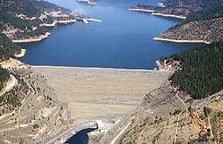
and Trinity Dam
along Lewiston Lake
. SR 3 passes through the towns of Covington Mill, Trinity Center
, and Wyntoon
before paralleling the Trinity River
as Weaverville-Scott Mountain Road and crossing the Scott Mountains
and the Pacific Crest Trail
at 5205 feet (1,586.5 m) into Siskiyou County
.
In Siskiyou County, SR 3 passes through Callahan
, Etna
, Greenview
, and Fort Jones
as it turns northeast to intersect with Interstate 5 in Yreka
. At this point, State Route 263
continues in the northerly direction towards State Route 96
; SR 3 turns east to its northern terminus in the incorporated city of Montague
.
north to Peanut
was added to the state highway system in 1907 as part of the Peanut Road, which became Route 35 in 1917. Route 35 was extended north from Peanut to Route 20 (SR 299
) near Douglas City
in 1933, and simultaneously a new Route 82 was created, running from Route 3 (I-5
) in the Yreka
area southwest to Etna
and east to Montague
. The gap between Douglas City and Etna was filled in 1959 with an extension of Route 82 south to Route 20 near Weaverville
; at the same time, the portion between Weaverville and Yreka was added to the California Freeway and Expressway System
, which identifies the main routes of transportation in the state of California. The State Route 3 designation was applied to the Peanut-Montague roadway in the 1964 renumbering. The overlap with temporary I-5
(along the portion where SR 3 runs concurrently
with Interstate 5 today) near Yreka was removed when the new I-5 bypass was built; the legislative definition was updated to reflect this in 1974, soon after the building of the bypass.
{| class=wikitable
|-
!County
!Location
!Postmile
!Destinations
!Notes
|-
|rowspan=3|Trinity
TRI L0.00-85.07
|
|L0.00
|
|
|-
|
| style="background:#dfd;"|L30.89
R58.11Indicates that the postmile represents the distance along SR 299
rather than SR 3.
| style="background:#dfd;"|
| style="background:#dfd;"|South end of SR 299 overlap
|-
|Weaverville
| style="background:#dfd;"|51.57
30.86
| style="background:#dfd;"|
| style="background:#dfd;"|North end of SR 299 overlap
|-
|rowspan=11|Siskiyou
SIS 0.41-54.19
|
|6.95
|Gazelle Callahan Road – Gazelle
|
|-
|Callahan
|8.80
|Cecilville Road – Cecilville
, Forks of Salmon
, Somes Bar
|
|-
|Fort Jones
|32.20
|Scott River Road – Scott Bar
|
|-
|rowspan=4|Yreka
| style="background:#dfd;"|L47.26
| style="background:#dfd;"| – Portland
, Redding
| style="background:#dfd;"|South end of I-5 Bus. overlap
|-
|L49.21
|.svg.png) Center Street to I-5
Center Street to I-5
|
|- style="background:#dfd;"
|L49.87
|
|North end of I-5 Bus. overlap
|-
|R47.38
| – Portland
, Redding
|
|-
|rowspan=3|Montague
||53.22
||
||South end of CR A28 overlap
|- style="background:#dfd;"
|
|
|North end of CR A28 overlap
|-
|rowspan=2|54.19
|rowspan=2|Ball Mountain Little Shasta Road – Ball Mountain
|rowspan=2|Continuation beyond the Montague
east city limit
|-
|
State highway
State highway, state road or state route can refer to one of three related concepts, two of them related to a state or provincial government in a country that is divided into states or provinces :#A...
in the U.S. state
U.S. state
A U.S. state is any one of the 50 federated states of the United States of America that share sovereignty with the federal government. Because of this shared sovereignty, an American is a citizen both of the federal entity and of his or her state of domicile. Four states use the official title of...
of California
California
California is a state located on the West Coast of the United States. It is by far the most populous U.S. state, and the third-largest by land area...
. It runs from State Route 36
California State Route 36
State Route 36 is an east–west state highway in the U.S. state of California that is routed from U.S. Route 101 in Humboldt County to U.S. Route 395 just east of Susanville in Lassen County. The portion of SR 36 travelling past Lassen Volcanic National Park and Lake Almanor is part of the...
north along the shore of Trinity Lake
Trinity Lake
Trinity Lake, previously called Clair Engle Lake, is a lake on the Trinity River formed by the Trinity Dam and located in Trinity County, California, The dam was built by the U.S. Bureau of Reclamation. The lake has a capacity of , making it one of the largest reservoirs in California. The lake's...
, Fort Jones
Fort Jones, California
Fort Jones is a city in the Scott Valley area of Siskiyou County, California, United States. The population was 839 at the 2010 census, up from 600 as of the 2000 census.-History:...
and Etna
Etna, California
Etna is a city in the Scott Valley area of Siskiyou County, California, United States. The population was 737 at the 2010 census, down from 781 at the 2000 census.-Geography:...
. The route approaches Yreka
Yreka, California
Yreka is the county seat of Siskiyou County, California, United States. The population was 7,765 at the 2010 census, up from 7,290 at the 2000 census.- History:...
, intersecting with Interstate 5, and turns east to Montague
Montague, California
Montague is a city in Siskiyou County, California, United States. The population was 1,443 at the 2010 census, down from 1,456 at the 2000 census.-Geography:Montague is located at ....
. The road was numbered SR 3 in 1964, and most of it has been part of the state highway system since 1933.
Route description
SR 3 is part of the California Freeway and Expressway SystemCalifornia Freeway and Expressway System
The California Freeway and Expressway System is a system of existing or planned freeways and expressways in the U.S. state of California. It is defined by the Streets and Highways Code.-List of roads in the system:*State Route 1 *State Route 2...
and is eligible for the State Scenic Highway System
State Scenic Highway System (California)
The State Scenic Highway System is a list of highways, mainly state highways, that have been designated by the California Department of Transportation as scenic highways. The California State Legislature, primarily through Section 263 of the Streets and Highways Code, makes highways eligible for...
. Caltrans has subsequently designated it as a scenic highway for its entire length.
State Route 3 begins at the junction with State Route 36
California State Route 36
State Route 36 is an east–west state highway in the U.S. state of California that is routed from U.S. Route 101 in Humboldt County to U.S. Route 395 just east of Susanville in Lassen County. The portion of SR 36 travelling past Lassen Volcanic National Park and Lake Almanor is part of the...
south of the town of Peanut
Peanut, California
Peanut is a tiny unincorporated community in Trinity County, California. It is located on Highway 3, south of Hayfork and north of Highway 36 at an elevation of 2499 feet....
in Trinity County
Trinity County, California
Trinity County is a large, rugged and mountainous, heavily forested county located in the northwestern portion of the U.S. state of California, along the Trinity River and within the Salmon/Klamath Mountains. It covers an area of over two million acres , and as of the 2010 census its population...
. SR-3 is also known as Bramlot Road from its southern terminus to Hayfork
Hayfork, California
Hayfork is a census-designated place in Trinity County, California, United States. The population was 2,368 at the 2010 census, up from 2,315 at the 2000 census...
. This stretch of road through the Shasta-Trinity National Forest
Shasta-Trinity National Forest
The Shasta-Trinity National Forest is a federally designated forest in northern California, USA. It is the largest National Forest in California and is managed by the United States Forest Service. The 2.2-million acre forest encompasses five wilderness areas, hundreds of mountain lakes and of...
parallels the Hayfork River. Once SR-3 reaches the town of Hayfork, it travels along Hyampom Road east and snakes through the mountains to Douglas City
Douglas City, California
Douglas City is a census-designated place in Trinity County, California. Douglas City sits at an elevation of . The ZIP Code is 96024. The community is inside area code 530...
and the junction with State Route 299. From there, SR 3 runs concurrently with SR 299 north to the town of Weaverville
Weaverville, California
Weaverville is a census-designated place and the county seat of Trinity County, California. The population was 3,600 at the 2010 census, up from 3,554 at the 2000 census.-History:Founded in 1850, Weaverville is a historic California Gold Rush town...
.
Whiskeytown-Shasta-Trinity National Recreation Area
The Whiskeytown-Shasta-Trinity National Recreation Area is a United States National Recreation Area in northern California. It has a total of of land, which is divided into three units, Whiskeytown, Shasta and Trinity. The recreation area was established in 1965 by the United States Congress. The...
and Trinity Dam
Trinity Dam
Trinity Dam is an earth dam on the Trinity River that forms Trinity Lake near Weaverville, California. Trinity Lake was previously called Clair Engle Lake. The earthfill dam was built by the U.S. Bureau of Reclamation. Construction was completed in 1962. Trinity Lake has a capacity of , making it...
along Lewiston Lake
Lewiston Lake
Lewiston Lake is a reservoir created by Lewiston Dam on the Trinity River, near the towns of Weaverville and Lewiston in Trinity County, California. It is used for transbasin diversion to the Sacramento River and flood control, as well as for hydroelectric generation, and is a popular destination...
. SR 3 passes through the towns of Covington Mill, Trinity Center
Trinity Center, California
Trinity Center is a census-designated place in Trinity County, California. Trinity Center is located north of Weaverville. It is home to Trinity Lake, a popular summer tourist destination. The telephone prefix is 266-xxxx or more rarely 286-xxxx...
, and Wyntoon
Wyntoon
Wyntoon is the name of a private estate on the McCloud River in rural Siskiyou County, California, owned by the Hearst Corporation. Famous architects Willis Polk, Bernard Maybeck and Julia Morgan all designed structures for Wyntoon....
before paralleling the Trinity River
Trinity River (California)
The Trinity River is the longest tributary of the Klamath River, approximately long, in northwestern California in the United States. It drains an area of the Coast Ranges, including the southern Klamath Mountains, northwest of the Sacramento Valley...
as Weaverville-Scott Mountain Road and crossing the Scott Mountains
Scott Mountains (California)
The Scott Mountains are a mountain range in Siskiyou County, California....
and the Pacific Crest Trail
Pacific Crest Trail
The Pacific Crest Trail is a long-distance mountain hiking and equestrian trail on the Western Seaboard of the United States. The southern terminus is at the California border with Mexico...
at 5205 feet (1,586.5 m) into Siskiyou County
Siskiyou County, California
Siskiyou County is a county located in the far northernmost part of the U.S. state of California, in the Shasta Cascade region on the Oregon border. Yreka is the county seat. Because of its substantial natural beauty, outdoor recreation opportunities, and Gold Rush era history, it is an important...
.
In Siskiyou County, SR 3 passes through Callahan
Callahan, California
Callahan is an unincorporated community in Siskiyou County, California, United States. Callahan is located on California State Route 3 south-southeast of Etna. Callahan has a post office with ZIP code 96014. The post office opened as Callahan's Ranch in 1858 and changed its name to Callahan in...
, Etna
Etna, California
Etna is a city in the Scott Valley area of Siskiyou County, California, United States. The population was 737 at the 2010 census, down from 781 at the 2000 census.-Geography:...
, Greenview
Greenview, California
Greenview is a census-designated place in Siskiyou County, California, United States. The population was 201 at the 2010 census, up from 200 at the 2000 census.-Geography:Greenview is located at ....
, and Fort Jones
Fort Jones, California
Fort Jones is a city in the Scott Valley area of Siskiyou County, California, United States. The population was 839 at the 2010 census, up from 600 as of the 2000 census.-History:...
as it turns northeast to intersect with Interstate 5 in Yreka
Yreka, California
Yreka is the county seat of Siskiyou County, California, United States. The population was 7,765 at the 2010 census, up from 7,290 at the 2000 census.- History:...
. At this point, State Route 263
California State Route 263
State Route 263 is a state highway in the U.S. state of California in Siskiyou County. It is also part of Business Loop 5 due to being a parallel route of Interstate 5 to the west. Route 263 connects Route 3 near the north city limits of Yreka to Route 96 eight miles north. It was once part of...
continues in the northerly direction towards State Route 96
California State Route 96
State Route 96 follows the Trinity and Klamath Rivers in Northern California. For most of the route it goes through the Karuk Tribal Reservation, the Yurok Tribal Reservation, and the Hoopa Tribal Reservation...
; SR 3 turns east to its northern terminus in the incorporated city of Montague
Montague, California
Montague is a city in Siskiyou County, California, United States. The population was 1,443 at the 2010 census, down from 1,456 at the 2000 census.-Geography:Montague is located at ....
.
History
The short piece from SR 36California State Route 36
State Route 36 is an east–west state highway in the U.S. state of California that is routed from U.S. Route 101 in Humboldt County to U.S. Route 395 just east of Susanville in Lassen County. The portion of SR 36 travelling past Lassen Volcanic National Park and Lake Almanor is part of the...
north to Peanut
Peanut, California
Peanut is a tiny unincorporated community in Trinity County, California. It is located on Highway 3, south of Hayfork and north of Highway 36 at an elevation of 2499 feet....
was added to the state highway system in 1907 as part of the Peanut Road, which became Route 35 in 1917. Route 35 was extended north from Peanut to Route 20 (SR 299
California State Route 299
State Route 299 is a state highway in the U.S. state of California that runs across the northern part of the state. It runs from Arcata on the Pacific Ocean to the border with Nevada. Between Arcata and Redding, Route 299 junctions with State Route 96 and is briefly co-signed with State Route 3. In...
) near Douglas City
Douglas City, California
Douglas City is a census-designated place in Trinity County, California. Douglas City sits at an elevation of . The ZIP Code is 96024. The community is inside area code 530...
in 1933, and simultaneously a new Route 82 was created, running from Route 3 (I-5
Interstate 5 in California
Interstate 5 is a major north–south route of the Interstate Highway System in the U.S. state of California. It begins at the Mexico – United States border at the San Ysidro crossing, goes north across the length of California and crosses into Oregon south of the Medford-Ashland metropolitan...
) in the Yreka
Yreka, California
Yreka is the county seat of Siskiyou County, California, United States. The population was 7,765 at the 2010 census, up from 7,290 at the 2000 census.- History:...
area southwest to Etna
Etna, California
Etna is a city in the Scott Valley area of Siskiyou County, California, United States. The population was 737 at the 2010 census, down from 781 at the 2000 census.-Geography:...
and east to Montague
Montague, California
Montague is a city in Siskiyou County, California, United States. The population was 1,443 at the 2010 census, down from 1,456 at the 2000 census.-Geography:Montague is located at ....
. The gap between Douglas City and Etna was filled in 1959 with an extension of Route 82 south to Route 20 near Weaverville
Weaverville, California
Weaverville is a census-designated place and the county seat of Trinity County, California. The population was 3,600 at the 2010 census, up from 3,554 at the 2000 census.-History:Founded in 1850, Weaverville is a historic California Gold Rush town...
; at the same time, the portion between Weaverville and Yreka was added to the California Freeway and Expressway System
California Freeway and Expressway System
The California Freeway and Expressway System is a system of existing or planned freeways and expressways in the U.S. state of California. It is defined by the Streets and Highways Code.-List of roads in the system:*State Route 1 *State Route 2...
, which identifies the main routes of transportation in the state of California. The State Route 3 designation was applied to the Peanut-Montague roadway in the 1964 renumbering. The overlap with temporary I-5
Interstate 5 in California
Interstate 5 is a major north–south route of the Interstate Highway System in the U.S. state of California. It begins at the Mexico – United States border at the San Ysidro crossing, goes north across the length of California and crosses into Oregon south of the Medford-Ashland metropolitan...
(along the portion where SR 3 runs concurrently
Concurrency (road)
A concurrency, overlap, or coincidence in a road network is an instance of one physical road bearing two or more different highway, motorway, or other route numbers...
with Interstate 5 today) near Yreka was removed when the new I-5 bypass was built; the legislative definition was updated to reflect this in 1974, soon after the building of the bypass.
Major intersections
- Note: Except where prefixed with a letter, postmiles were measured in 1964, based on the alignment as it existed at that time, and do not necessarily reflect current mileage. The numbers reset at county lines; the start and end postmiles in each county are given in the county column.
{| class=wikitable
|-
!County
!Location
!Postmile
!Destinations
!Notes
|-
|rowspan=3|Trinity
Trinity County, California
Trinity County is a large, rugged and mountainous, heavily forested county located in the northwestern portion of the U.S. state of California, along the Trinity River and within the Salmon/Klamath Mountains. It covers an area of over two million acres , and as of the 2010 census its population...
TRI L0.00-85.07
|
|L0.00
|
|
|-
|
| style="background:#dfd;"|L30.89
R58.11Indicates that the postmile represents the distance along SR 299
California State Route 299
State Route 299 is a state highway in the U.S. state of California that runs across the northern part of the state. It runs from Arcata on the Pacific Ocean to the border with Nevada. Between Arcata and Redding, Route 299 junctions with State Route 96 and is briefly co-signed with State Route 3. In...
rather than SR 3.
| style="background:#dfd;"|
| style="background:#dfd;"|South end of SR 299 overlap
|-
|Weaverville
Weaverville, California
Weaverville is a census-designated place and the county seat of Trinity County, California. The population was 3,600 at the 2010 census, up from 3,554 at the 2000 census.-History:Founded in 1850, Weaverville is a historic California Gold Rush town...
| style="background:#dfd;"|51.57
30.86
| style="background:#dfd;"|
| style="background:#dfd;"|North end of SR 299 overlap
|-
|rowspan=11|Siskiyou
Siskiyou County, California
Siskiyou County is a county located in the far northernmost part of the U.S. state of California, in the Shasta Cascade region on the Oregon border. Yreka is the county seat. Because of its substantial natural beauty, outdoor recreation opportunities, and Gold Rush era history, it is an important...
SIS 0.41-54.19
|
|6.95
|Gazelle Callahan Road – Gazelle
Gazelle, California
Gazelle is a census-designated place in Siskiyou County, California, United States. The population was 70 at the 2010 census, down from 136 at the 2000 census.-Geography:Gazelle is located at ....
|
|-
|Callahan
Callahan, California
Callahan is an unincorporated community in Siskiyou County, California, United States. Callahan is located on California State Route 3 south-southeast of Etna. Callahan has a post office with ZIP code 96014. The post office opened as Callahan's Ranch in 1858 and changed its name to Callahan in...
|8.80
|Cecilville Road – Cecilville
Cecilville, California
Cecilville is a small unincorporated community in Siskiyou County, California, United States. It is on the south fork of the Salmon River and was established when the area was settled by miners during the Gold Rush.-External links:*...
, Forks of Salmon
Forks of Salmon, California
Forks of Salmon is an unincorporated community of Siskiyou County in northern California, USA. The town is situated at the confluence of the north and south forks of the Salmon River, hence its name. The ZIP Code is 96031...
, Somes Bar
Somes Bar, California
Somes Bar or Sommes Bar, is an unincorporated community in Siskiyou County, California, United States. Somes Bar is located on the Salmon River northwest of Forks of Salmon. Somes Bar has a post office with ZIP code 95568, which opened in 1875. Somes Bar is named after George Somes, who found...
|
|-
|Fort Jones
Fort Jones, California
Fort Jones is a city in the Scott Valley area of Siskiyou County, California, United States. The population was 839 at the 2010 census, up from 600 as of the 2000 census.-History:...
|32.20
|Scott River Road – Scott Bar
Scott Bar, California
Scott Bar is an unincorporated community in Siskiyou County, California, United States. Scott Bar is located on the Scott River west of Yreka. Scott Bar has a post office with ZIP code 96085. According to the 2000 census, ZIP Code 96085 had a population of 68. The post office opened as Scott River...
|
|-
|rowspan=4|Yreka
Yreka, California
Yreka is the county seat of Siskiyou County, California, United States. The population was 7,765 at the 2010 census, up from 7,290 at the 2000 census.- History:...
| style="background:#dfd;"|L47.26
| style="background:#dfd;"| – Portland
Portland, Oregon
Portland is a city located in the Pacific Northwest, near the confluence of the Willamette and Columbia rivers in the U.S. state of Oregon. As of the 2010 Census, it had a population of 583,776, making it the 29th most populous city in the United States...
, Redding
Redding, California
Redding is a city in far-Northern California. It is the county seat of Shasta County, California, USA. With a population of 89,861, according to the 2010 Census...
| style="background:#dfd;"|South end of I-5 Bus. overlap
|-
|L49.21
|
|
|- style="background:#dfd;"
|L49.87
|
|North end of I-5 Bus. overlap
|-
|R47.38
| – Portland
Portland, Oregon
Portland is a city located in the Pacific Northwest, near the confluence of the Willamette and Columbia rivers in the U.S. state of Oregon. As of the 2010 Census, it had a population of 583,776, making it the 29th most populous city in the United States...
, Redding
Redding, California
Redding is a city in far-Northern California. It is the county seat of Shasta County, California, USA. With a population of 89,861, according to the 2010 Census...
|
|-
|rowspan=3|Montague
Montague, California
Montague is a city in Siskiyou County, California, United States. The population was 1,443 at the 2010 census, down from 1,456 at the 2000 census.-Geography:Montague is located at ....
||53.22
||
||South end of CR A28 overlap
|- style="background:#dfd;"
|
|
|North end of CR A28 overlap
|-
|rowspan=2|54.19
|rowspan=2|Ball Mountain Little Shasta Road – Ball Mountain
|rowspan=2|Continuation beyond the Montague
Montague, California
Montague is a city in Siskiyou County, California, United States. The population was 1,443 at the 2010 census, down from 1,456 at the 2000 census.-Geography:Montague is located at ....
east city limit
|-
|