
Death Valley Junction, California
Encyclopedia
Death Valley Junction is a tiny Mojave Desert
community in unincorporated
Inyo County, California
, at the intersection of SR 190
and SR 127
, just east of Death Valley National Park
. The zip code is 92328, the elevation is 2041 ft (622 m), and the population fewer than 20. The city limits sign reports a population of 4. The U.S. Geological Survey lists a historic variant name of Amargosa for the community which is shown as the primary name on an official State of Nevada map from 1971. Its existence and name are official with a USGS feature ID of 1656477. The default format for wired phone numbers in this community is (760
) 852-xxxx.
Death Valley Junction is home to the Amargosa Opera House and Hotel
, where resident Marta Becket
has staged dance
and mime
shows since the late 1960s. The hotel is operating and the shows continue at the opera house, but beyond these maintained areas, the town is in a state of disrepair. There are no gas stations, and only one restaurant. The single restaurant, T&T Cafe, is part of the Amargosa Opera House and Hotel, but is not run by the hotel staff.
The community's location, 27 miles (43.5 km) east-southeast of Furnace Creek Inn
, on the east side of Death Valley
is south of Nevada's Amargosa Valley
and near Ash Meadows National Wildlife Refuge
. South on SR127 is the town of Shoshone, California
. The closest straight-line distance to the Nevada
state line is roughly five miles northeast.
Government documents show an effort by the Timbisha Shoshone
tribal government to acquire about 7200 acres (29 km²) in the area during 1999 to 2000. This includes areas for residences and the official federal sanction to use some government lands for traditional ceremonies. It's unclear if these efforts, which were documented in the Congressional Record, succeeded.
started operating between Ryan, CA and Death Valley Junction. It carried borax
until 1928, when operations ceased. The name of the town was changed from Amargosa ("bitter water" in a Paiute
language) to Death Valley Junction. From 1923 to 1925 the Pacific Coast Borax Company
constructed buildings in the town, hiring architect Alexander Hamilton McCulloch to design a Spanish Colonial Revival whistle stop
centered at the hotel, theater and office complex building, now known as the Amargosa Opera House and Hotel
. The town began to decline in the mid twentieth century, until 1967 when dancer and actress Marta Becket, with help from benefactors, leased, then purchased the hotel and theater complex. The Amargosa is now owned by a non-profit organization.
In 1980 the town was included in the National Register of Historic Places
as the "Death Valley Junction Historic District."
The Death Valley post office opened in 1908 and transferred to Furnace Creek Ranch in 1961. The Amargosa post office opened in 1962, changed its name to Death Valley Junction in 1968.
When the Death Valley Railroad
was established in 1914, it used 3.19 miles (5.1 km) of tracks belonging to the Tonopah and Tidewater Railroad
east-southeast of Death Valley Junction to Horton
.
 Local wired telephones were manual telephone service until the 1980s. To reach a phone in Death Valley Junction when the area was under manual service required dialing the operator and asking for Death Valley Junction, California, Toll Station (and the one-digit number). Placing an outbound call required lifting the receiver and waiting for an operator. The operator who answered was in Los Angeles. The area is now in area code 760
.
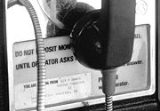
At right is the bottom instruction card of Death Valley Junction #2, a non-dial Western Electric 1A1 coin collector located at the Amagosa Opera House. Picture was taken in the late 1970s.
Death Valley Junction is located in the 18th Senate
District, represented by Republican
Roy Ashburn
, and in the 18th Assembly
District, represented by Republican Bill Maze
. Federally, Death Valley Junction is located in California's 25th congressional district
, which has a Cook PVI
of R +7 and is represented by Republican Buck McKeon
.
Mojave Desert
The Mojave Desert occupies a significant portion of southeastern California and smaller parts of central California, southern Nevada, southwestern Utah and northwestern Arizona, in the United States...
community in unincorporated
Unincorporated area
In law, an unincorporated area is a region of land that is not a part of any municipality.To "incorporate" in this context means to form a municipal corporation, a city, town, or village with its own government. An unincorporated community is usually not subject to or taxed by a municipal government...
Inyo County, California
California
California is a state located on the West Coast of the United States. It is by far the most populous U.S. state, and the third-largest by land area...
, at the intersection of SR 190
California State Route 190
State Route 190 is a state highway in the U.S. state of California that is split into two parts by the Sierra Nevada. The western portion of begins at Tipton at a junction with State Route 99 and heads east towards Porterville before ending at Quaking Aspen in the Sequoia National Forest...
and SR 127
California State Route 127
State Route 127 is a California state highway that connects Interstate 15 to Nevada State Route 373, passing through Death Valley National Park....
, just east of Death Valley National Park
Death Valley National Park
Death Valley National Park is a national park in the U.S. states of California and Nevada located east of the Sierra Nevada in the arid Great Basin of the United States. The park protects the northwest corner of the Mojave Desert and contains a diverse desert environment of salt-flats, sand dunes,...
. The zip code is 92328, the elevation is 2041 ft (622 m), and the population fewer than 20. The city limits sign reports a population of 4. The U.S. Geological Survey lists a historic variant name of Amargosa for the community which is shown as the primary name on an official State of Nevada map from 1971. Its existence and name are official with a USGS feature ID of 1656477. The default format for wired phone numbers in this community is (760
Area code 760
Image:Area_code_442.svg|right|Map of California area codes in blue with 442/760 in redrect 65 82 92 100 Area code 916rect 220 242 245 256 Area code 909rect 243 274 265 287 Area code 951rect 136 323 160 338 Area code 858...
) 852-xxxx.
Death Valley Junction is home to the Amargosa Opera House and Hotel
Amargosa Opera House and Hotel
Amargosa Opera House and Hotel is a historic building and cultural center located in Death Valley Junction, in eastern Inyo County, California near Death Valley National Park. Resident artist Marta Becket has staged dance and mime shows there since the late 1960s...
, where resident Marta Becket
Marta Becket
Marta Becket is an actress, dancer, choreographer and painter who performed for more than four decades at her own theater, the Amargosa Opera House in Death Valley Junction, California...
has staged dance
Dance
Dance is an art form that generally refers to movement of the body, usually rhythmic and to music, used as a form of expression, social interaction or presented in a spiritual or performance setting....
and mime
Mime artist
A mime artist is someone who uses mime as a theatrical medium or as a performance art, involving miming, or the acting out a story through body motions, without use of speech. In earlier times, in English, such a performer was referred to as a mummer...
shows since the late 1960s. The hotel is operating and the shows continue at the opera house, but beyond these maintained areas, the town is in a state of disrepair. There are no gas stations, and only one restaurant. The single restaurant, T&T Cafe, is part of the Amargosa Opera House and Hotel, but is not run by the hotel staff.
The community's location, 27 miles (43.5 km) east-southeast of Furnace Creek Inn
Furnace Creek Inn, California
Furnace Creek Inn is a former settlement in Inyo County, California. It was located near the mouth of the Furnace Creek Wash, southeast of Stovepipe Wells....
, on the east side of Death Valley
Death Valley
Death Valley is a desert valley located in Eastern California. Situated within the Mojave Desert, it features the lowest, driest, and hottest locations in North America. Badwater, a basin located in Death Valley, is the specific location of the lowest elevation in North America at 282 feet below...
is south of Nevada's Amargosa Valley
Amargosa Valley, Nevada
Amargosa Valley is an unincorporated community in Nye County, in the U.S. state of Nevada.-Description:The community is named for the Amargosa River which flows through the valley from its origination in Nevada to its terminus in Death Valley, California...
and near Ash Meadows National Wildlife Refuge
Ash Meadows National Wildlife Refuge
The Ash Meadows National Wildlife Refuge is a protected wildlife refuge, administered by the U.S. Fish and Wildlife Service, located west-northwest of Las Vegas, Nevada, in southern Nye County...
. South on SR127 is the town of Shoshone, California
Shoshone, California
Shoshone is a census-designated place in Inyo County, California, United States. Shoshone is located on the Tonopah and Tidewater Railroad east of Epaulet Peak, at an elevation of 1585 feet . The population was 31 at the 2010 census, down from 52 at the 2000 census.The town was founded in 1910...
. The closest straight-line distance to the Nevada
Nevada
Nevada is a state in the western, mountain west, and southwestern regions of the United States. With an area of and a population of about 2.7 million, it is the 7th-largest and 35th-most populous state. Over two-thirds of Nevada's people live in the Las Vegas metropolitan area, which contains its...
state line is roughly five miles northeast.
Government documents show an effort by the Timbisha Shoshone
Shoshone
The Shoshone or Shoshoni are a Native American tribe in the United States with three large divisions: the Northern, the Western and the Eastern....
tribal government to acquire about 7200 acres (29 km²) in the area during 1999 to 2000. This includes areas for residences and the official federal sanction to use some government lands for traditional ceremonies. It's unclear if these efforts, which were documented in the Congressional Record, succeeded.
History
In 1914 the Death Valley RailroadDeath Valley Railroad
The Death Valley Railroad was a narrow gauge railroad that operated in California's Death Valley.It was built in 1914 by the Pacific Coast Borax Company to carry borax with the route running from Ryan, California, located just east of Death Valley National Park, to Death Valley Junction, a distance...
started operating between Ryan, CA and Death Valley Junction. It carried borax
Borax
Borax, also known as sodium borate, sodium tetraborate, or disodium tetraborate, is an important boron compound, a mineral, and a salt of boric acid. It is usually a white powder consisting of soft colorless crystals that dissolve easily in water.Borax has a wide variety of uses...
until 1928, when operations ceased. The name of the town was changed from Amargosa ("bitter water" in a Paiute
Paiute
Paiute refers to three closely related groups of Native Americans — the Northern Paiute of California, Idaho, Nevada and Oregon; the Owens Valley Paiute of California and Nevada; and the Southern Paiute of Arizona, southeastern California and Nevada, and Utah.-Origin of name:The origin of...
language) to Death Valley Junction. From 1923 to 1925 the Pacific Coast Borax Company
Pacific Coast Borax Company
The Pacific Coast Borax Company was a United States mining company founded in 1890 by the American borax magnate Francis "Borax" Smith, the "Borax King".-History:...
constructed buildings in the town, hiring architect Alexander Hamilton McCulloch to design a Spanish Colonial Revival whistle stop
Request stop
In public transport, a request stop or flag stop describes a stopping point at which trains or buses stop only on an as-need or request basis; that is, only if there are passengers to be picked up or dropped off. In this way, infrequently used stopping points can be served efficiently.Trains save...
centered at the hotel, theater and office complex building, now known as the Amargosa Opera House and Hotel
Amargosa Opera House and Hotel
Amargosa Opera House and Hotel is a historic building and cultural center located in Death Valley Junction, in eastern Inyo County, California near Death Valley National Park. Resident artist Marta Becket has staged dance and mime shows there since the late 1960s...
. The town began to decline in the mid twentieth century, until 1967 when dancer and actress Marta Becket, with help from benefactors, leased, then purchased the hotel and theater complex. The Amargosa is now owned by a non-profit organization.
In 1980 the town was included in the National Register of Historic Places
National Register of Historic Places
The National Register of Historic Places is the United States government's official list of districts, sites, buildings, structures, and objects deemed worthy of preservation...
as the "Death Valley Junction Historic District."
The Death Valley post office opened in 1908 and transferred to Furnace Creek Ranch in 1961. The Amargosa post office opened in 1962, changed its name to Death Valley Junction in 1968.
When the Death Valley Railroad
Death Valley Railroad
The Death Valley Railroad was a narrow gauge railroad that operated in California's Death Valley.It was built in 1914 by the Pacific Coast Borax Company to carry borax with the route running from Ryan, California, located just east of Death Valley National Park, to Death Valley Junction, a distance...
was established in 1914, it used 3.19 miles (5.1 km) of tracks belonging to the Tonopah and Tidewater Railroad
Tonopah and Tidewater Railroad
The Tonopah and Tidewater Railroad, the T&T, was a class II railroad extending through remote reaches of the Mojave Desert from the Santa Fe Railway railhead at Ludlow, California, through Death Valley and Amargosa Valley, terminating at the Mining towns of Tonopah and Goldfield in the Great Basin...
east-southeast of Death Valley Junction to Horton
Horton, California
Horton is a former settlement in Inyo County, California.It was located at the junction of the Death Valley and Tonopah and Tidewater Railroads east-southeast Death Valley Junction.The name honors Ben Horton, railroad company official....
.
Telephone history
Area code 760
Image:Area_code_442.svg|right|Map of California area codes in blue with 442/760 in redrect 65 82 92 100 Area code 916rect 220 242 245 256 Area code 909rect 243 274 265 287 Area code 951rect 136 323 160 338 Area code 858...
.
At right is the bottom instruction card of Death Valley Junction #2, a non-dial Western Electric 1A1 coin collector located at the Amagosa Opera House. Picture was taken in the late 1970s.
Politics
In the state legislatureCalifornia State Legislature
The California State Legislature is the state legislature of the U.S. state of California. It is a bicameral body consisting of the lower house, the California State Assembly, with 80 members, and the upper house, the California State Senate, with 40 members...
Death Valley Junction is located in the 18th Senate
California State Senate
The California State Senate is the upper house of the California State Legislature. There are 40 state senators. The state legislature meets in the California State Capitol in Sacramento. The Lieutenant Governor is the ex officio President of the Senate and may break a tied vote...
District, represented by Republican
Republican Party (United States)
The Republican Party is one of the two major contemporary political parties in the United States, along with the Democratic Party. Founded by anti-slavery expansion activists in 1854, it is often called the GOP . The party's platform generally reflects American conservatism in the U.S...
Roy Ashburn
Roy Ashburn
Roy Arthur Ashburn is an American politician from Kern County, California. A Republican, he served as a California State Senator from 2002 to 2010 representing the 18th district. He previously served three terms in the California State Assembly, representing the 32nd district and 12 years on the...
, and in the 18th Assembly
California State Assembly
The California State Assembly is the lower house of the California State Legislature. There are 80 members in the Assembly, representing an approximately equal number of constituents, with each district having a population of at least 420,000...
District, represented by Republican Bill Maze
Bill Maze
Bill Maze is an American politician from California and a member of the Republican Party. Maze is the president of Citizens for Saving California Farming Industries, a non-profit dedicated to dividing California into two states....
. Federally, Death Valley Junction is located in California's 25th congressional district
California's 25th congressional district
California's 25th congressional district is a congressional district in the U.S. state of California that covers part of Los Angeles County and extends out to broad stretches of interior California along the Nevada border. It includes the cities of Santa Clarita, Palmdale, Lancaster, and the...
, which has a Cook PVI
Cook Partisan Voting Index
The Cook Partisan Voting Index , sometimes referred to as simply the Partisan Voting Index , is a measurement of how strongly an American congressional district or state leans toward one political party compared to the nation as a whole...
of R +7 and is represented by Republican Buck McKeon
Howard McKeon
Howard Philip "Buck" McKeon is the U.S. Representative for , serving since 1993. He is a member of the Republican Party.-Early life, education and career:...
.