
Shoshone, California
Encyclopedia
Shoshone is a census-designated place
(CDP) in Inyo County
, California
, United States
. Shoshone is located on the Tonopah and Tidewater Railroad
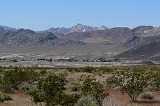
14 miles (23 km) east of Epaulet Peak, at an elevation of 1585 feet (483 m). The population was 31 at the 2010 census, down from 52 at the 2000 census.
The town was founded in 1910. Although small, it is notable as a southern gateway to Death Valley National Park
; in addition to being a junction of roads leading from Baker, California
and Pahrump, Nevada
, it has the last services available before the Furnace Creek area in the park. The commercial district of the town, including a Post Office, gas station, restaurant, bar and coffee house, is just north of the southern intersection of California State Routes 127 and 178.
Shoshone has a single 2,380 foot (725 m) airstrip across SR 127 from the commercial district. It is open to the public and gets about 58 flights per month.
, the CDP has a total area of 28.7 square miles (74.3 km²), over 99% of it land.
A post office operated at Shoshone from 1915, closed for part of 1920.
was 1.1 people per square mile (0.4/km²). The racial makeup of Shoshone was 28 (90.3%) White, 1 (3.2%) African American, 1 (3.2%) Native American, 0 (0.0%) Asian, 0 (0.0%) Pacific Islander, 0 (0.0%) from other races
, and 1 (3.2%) from two or more races. Hispanic or Latino of any race were 0 persons (0.0%).
The Census reported that 31 people (100% of the population) lived in households, 0 (0%) lived in non-institutionalized group quarters, and 0 (0%) were institutionalized.
There were 17 households, out of which 2 (11.8%) had children under the age of 18 living in them, 4 (23.5%) were opposite-sex married couples
living together, 2 (11.8%) had a female householder with no husband present, 0 (0%) had a male householder with no wife present. There were 4 (23.5%) unmarried opposite-sex partnerships
, and 0 (0%) same-sex married couples or partnerships. 6 households (35.3%) were made up of individuals and 4 (23.5%) had someone living alone who was 65 years of age or older. The average household size was 1.82. There were 6 families
(35.3% of all households); the average family size was 2.50.
The population was spread out with 3 people (9.7%) under the age of 18, 0 people (0%) aged 18 to 24, 13 people (41.9%) aged 25 to 44, 10 people (32.3%) aged 45 to 64, and 5 people (16.1%) who were 65 years of age or older. The median age was 44.5 years. For every 100 females there were 93.8 males. For every 100 females age 18 and over, there were 100.0 males.
There were 31 housing units at an average density of 1.1 per square mile (0.4/km²), of which 5 (29.4%) were owner-occupied, and 12 (70.6%) were occupied by renters. The homeowner vacancy rate was 16.7%; the rental vacancy rate was 20.0%. 9 people (29.0% of the population) lived in owner-occupied housing units and 22 people (71.0%) lived in rental housing units.
of 2000, there were 52 people, 26 households, and 17 families residing in the CDP. The population density
was 1.8 people per square mile (0.7/km²). There were 34 housing units at an average density of 1.2 per square mile (0.5/km²). The racial makeup of the CDP was 88.46% White
, 5.77% Native American
, and 5.77% from two or more races. 7.69% of the population were Hispanic
or Latino
of any race.
There were 26 households out of which 15.4% had children under the age of 18 living with them, 53.8% were married couples
living together, 11.5% had a female householder with no husband present, and 30.8% were non-families. 26.9% of all households were made up of individuals and 11.5% had someone living alone who was 65 years of age or older. The average household size was 2.00 and the average family size was 2.22.
In the CDP the population was spread out with 11.5% under the age of 18, 21.2% from 25 to 44, 28.8% from 45 to 64, and 38.5% who were 65 years of age or older. The median age was 56 years. For every 100 females there were 85.7 males. For every 100 females age 18 and over, there were 76.9 males.
The median income for a household in the CDP was $66,250, and the median income for a family was $61,750. Males had a median income of $31,406 versus $41,500 for females. The per capita income
for the CDP was $27,051. There were no families and 4.8% of the population living below the poverty line, including no one under 18 and no one over 64.
Shoshone is located in the 18th Senate
District, represented by Republican
Roy Ashburn
, and in the 34th Assembly
District, represented by Republican Bill Maze
. Federally, Shoshone is located in California's 25th congressional district
, which has a Cook PVI
of R +7 and is represented by Republican Buck McKeon
.
Census-designated place
A census-designated place is a concentration of population identified by the United States Census Bureau for statistical purposes. CDPs are delineated for each decennial census as the statistical counterparts of incorporated places such as cities, towns and villages...
(CDP) in Inyo County
Inyo County, California
-National protected areas:* Death Valley National Park * Inyo National Forest * Manzanar National Historic Site-Major highways:* U.S. Route 6* U.S. Route 395* State Route 127* State Route 136* State Route 168* State Route 178...
, California
California
California is a state located on the West Coast of the United States. It is by far the most populous U.S. state, and the third-largest by land area...
, United States
United States
The United States of America is a federal constitutional republic comprising fifty states and a federal district...
. Shoshone is located on the Tonopah and Tidewater Railroad
Tonopah and Tidewater Railroad
The Tonopah and Tidewater Railroad, the T&T, was a class II railroad extending through remote reaches of the Mojave Desert from the Santa Fe Railway railhead at Ludlow, California, through Death Valley and Amargosa Valley, terminating at the Mining towns of Tonopah and Goldfield in the Great Basin...
14 miles (23 km) east of Epaulet Peak, at an elevation of 1585 feet (483 m). The population was 31 at the 2010 census, down from 52 at the 2000 census.
The town was founded in 1910. Although small, it is notable as a southern gateway to Death Valley National Park
Death Valley National Park
Death Valley National Park is a national park in the U.S. states of California and Nevada located east of the Sierra Nevada in the arid Great Basin of the United States. The park protects the northwest corner of the Mojave Desert and contains a diverse desert environment of salt-flats, sand dunes,...
; in addition to being a junction of roads leading from Baker, California
Baker, California
Baker is a census-designated place located in San Bernardino County, California, USA. As of the 2010 census, the town had a total population of 735.Baker was founded as a station on the Tonopah and Tidewater Railroad in 1908,...
and Pahrump, Nevada
Pahrump, Nevada
-Demographics:As of the census of 2000, there were 24,631 people, 10,153 households, and 7,127 families residing in the CDP. The population density was 82.7 people per square mile . There were 11,651 housing units at an average density of 39.1 per square mile...
, it has the last services available before the Furnace Creek area in the park. The commercial district of the town, including a Post Office, gas station, restaurant, bar and coffee house, is just north of the southern intersection of California State Routes 127 and 178.
Shoshone has a single 2,380 foot (725 m) airstrip across SR 127 from the commercial district. It is open to the public and gets about 58 flights per month.
Geography
According to the United States Census BureauUnited States Census Bureau
The United States Census Bureau is the government agency that is responsible for the United States Census. It also gathers other national demographic and economic data...
, the CDP has a total area of 28.7 square miles (74.3 km²), over 99% of it land.
History
Shoshone was founded in 1910 by Ralph Jacobus "Dad" Fairbanks, a Death Valley businessman.A post office operated at Shoshone from 1915, closed for part of 1920.
2010
The 2010 United States Census reported that Shoshone had a population of 31. The population densityPopulation density
Population density is a measurement of population per unit area or unit volume. It is frequently applied to living organisms, and particularly to humans...
was 1.1 people per square mile (0.4/km²). The racial makeup of Shoshone was 28 (90.3%) White, 1 (3.2%) African American, 1 (3.2%) Native American, 0 (0.0%) Asian, 0 (0.0%) Pacific Islander, 0 (0.0%) from other races
Race (United States Census)
Race and ethnicity in the United States Census, as defined by the Federal Office of Management and Budget and the United States Census Bureau, are self-identification data items in which residents choose the race or races with which they most closely identify, and indicate whether or not they are...
, and 1 (3.2%) from two or more races. Hispanic or Latino of any race were 0 persons (0.0%).
The Census reported that 31 people (100% of the population) lived in households, 0 (0%) lived in non-institutionalized group quarters, and 0 (0%) were institutionalized.
There were 17 households, out of which 2 (11.8%) had children under the age of 18 living in them, 4 (23.5%) were opposite-sex married couples
Marriage
Marriage is a social union or legal contract between people that creates kinship. It is an institution in which interpersonal relationships, usually intimate and sexual, are acknowledged in a variety of ways, depending on the culture or subculture in which it is found...
living together, 2 (11.8%) had a female householder with no husband present, 0 (0%) had a male householder with no wife present. There were 4 (23.5%) unmarried opposite-sex partnerships
POSSLQ
POSSLQ is an abbreviation for "Persons of Opposite Sex Sharing Living Quarters," a term coined in the late 1970s by the United States Census Bureau as part of an effort to more accurately gauge the prevalence of cohabitation in American households....
, and 0 (0%) same-sex married couples or partnerships. 6 households (35.3%) were made up of individuals and 4 (23.5%) had someone living alone who was 65 years of age or older. The average household size was 1.82. There were 6 families
Family (U.S. Census)
A family or family household is defined by the United States Census Bureau for statistical purposes as "a householder and one or more other people related to the householder by birth, marriage, or adoption. They do not include same-sex married couples even if the marriage was performed in a state...
(35.3% of all households); the average family size was 2.50.
The population was spread out with 3 people (9.7%) under the age of 18, 0 people (0%) aged 18 to 24, 13 people (41.9%) aged 25 to 44, 10 people (32.3%) aged 45 to 64, and 5 people (16.1%) who were 65 years of age or older. The median age was 44.5 years. For every 100 females there were 93.8 males. For every 100 females age 18 and over, there were 100.0 males.
There were 31 housing units at an average density of 1.1 per square mile (0.4/km²), of which 5 (29.4%) were owner-occupied, and 12 (70.6%) were occupied by renters. The homeowner vacancy rate was 16.7%; the rental vacancy rate was 20.0%. 9 people (29.0% of the population) lived in owner-occupied housing units and 22 people (71.0%) lived in rental housing units.
2000
As of the censusCensus
A census is the procedure of systematically acquiring and recording information about the members of a given population. It is a regularly occurring and official count of a particular population. The term is used mostly in connection with national population and housing censuses; other common...
of 2000, there were 52 people, 26 households, and 17 families residing in the CDP. The population density
Population density
Population density is a measurement of population per unit area or unit volume. It is frequently applied to living organisms, and particularly to humans...
was 1.8 people per square mile (0.7/km²). There were 34 housing units at an average density of 1.2 per square mile (0.5/km²). The racial makeup of the CDP was 88.46% White
Race (United States Census)
Race and ethnicity in the United States Census, as defined by the Federal Office of Management and Budget and the United States Census Bureau, are self-identification data items in which residents choose the race or races with which they most closely identify, and indicate whether or not they are...
, 5.77% Native American
Race (United States Census)
Race and ethnicity in the United States Census, as defined by the Federal Office of Management and Budget and the United States Census Bureau, are self-identification data items in which residents choose the race or races with which they most closely identify, and indicate whether or not they are...
, and 5.77% from two or more races. 7.69% of the population were Hispanic
Race (United States Census)
Race and ethnicity in the United States Census, as defined by the Federal Office of Management and Budget and the United States Census Bureau, are self-identification data items in which residents choose the race or races with which they most closely identify, and indicate whether or not they are...
or Latino
Race (United States Census)
Race and ethnicity in the United States Census, as defined by the Federal Office of Management and Budget and the United States Census Bureau, are self-identification data items in which residents choose the race or races with which they most closely identify, and indicate whether or not they are...
of any race.
There were 26 households out of which 15.4% had children under the age of 18 living with them, 53.8% were married couples
Marriage
Marriage is a social union or legal contract between people that creates kinship. It is an institution in which interpersonal relationships, usually intimate and sexual, are acknowledged in a variety of ways, depending on the culture or subculture in which it is found...
living together, 11.5% had a female householder with no husband present, and 30.8% were non-families. 26.9% of all households were made up of individuals and 11.5% had someone living alone who was 65 years of age or older. The average household size was 2.00 and the average family size was 2.22.
In the CDP the population was spread out with 11.5% under the age of 18, 21.2% from 25 to 44, 28.8% from 45 to 64, and 38.5% who were 65 years of age or older. The median age was 56 years. For every 100 females there were 85.7 males. For every 100 females age 18 and over, there were 76.9 males.
The median income for a household in the CDP was $66,250, and the median income for a family was $61,750. Males had a median income of $31,406 versus $41,500 for females. The per capita income
Per capita income
Per capita income or income per person is a measure of mean income within an economic aggregate, such as a country or city. It is calculated by taking a measure of all sources of income in the aggregate and dividing it by the total population...
for the CDP was $27,051. There were no families and 4.8% of the population living below the poverty line, including no one under 18 and no one over 64.
Politics
In the state legislatureCalifornia State Legislature
The California State Legislature is the state legislature of the U.S. state of California. It is a bicameral body consisting of the lower house, the California State Assembly, with 80 members, and the upper house, the California State Senate, with 40 members...
Shoshone is located in the 18th Senate
California State Senate
The California State Senate is the upper house of the California State Legislature. There are 40 state senators. The state legislature meets in the California State Capitol in Sacramento. The Lieutenant Governor is the ex officio President of the Senate and may break a tied vote...
District, represented by Republican
Republican Party (United States)
The Republican Party is one of the two major contemporary political parties in the United States, along with the Democratic Party. Founded by anti-slavery expansion activists in 1854, it is often called the GOP . The party's platform generally reflects American conservatism in the U.S...
Roy Ashburn
Roy Ashburn
Roy Arthur Ashburn is an American politician from Kern County, California. A Republican, he served as a California State Senator from 2002 to 2010 representing the 18th district. He previously served three terms in the California State Assembly, representing the 32nd district and 12 years on the...
, and in the 34th Assembly
California State Assembly
The California State Assembly is the lower house of the California State Legislature. There are 80 members in the Assembly, representing an approximately equal number of constituents, with each district having a population of at least 420,000...
District, represented by Republican Bill Maze
Bill Maze
Bill Maze is an American politician from California and a member of the Republican Party. Maze is the president of Citizens for Saving California Farming Industries, a non-profit dedicated to dividing California into two states....
. Federally, Shoshone is located in California's 25th congressional district
California's 25th congressional district
California's 25th congressional district is a congressional district in the U.S. state of California that covers part of Los Angeles County and extends out to broad stretches of interior California along the Nevada border. It includes the cities of Santa Clarita, Palmdale, Lancaster, and the...
, which has a Cook PVI
Cook Partisan Voting Index
The Cook Partisan Voting Index , sometimes referred to as simply the Partisan Voting Index , is a measurement of how strongly an American congressional district or state leans toward one political party compared to the nation as a whole...
of R +7 and is represented by Republican Buck McKeon
Howard McKeon
Howard Philip "Buck" McKeon is the U.S. Representative for , serving since 1993. He is a member of the Republican Party.-Early life, education and career:...
.