

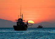
that is part of the Pacific Ocean
, encompassing an area from the Singapore
and Malacca Straits to the Strait of Taiwan of around 3500000 square kilometres (1,351,357.6 sq mi). The area's importance largely results from one-third of the world's shipping transiting through its waters, and that it is believed to hold huge oil and gas reserves beneath its seabed.
It is located
- south of mainland ChinaMainland ChinaMainland China, the Chinese mainland or simply the mainland, is a geopolitical term that refers to the area under the jurisdiction of the People's Republic of China . According to the Taipei-based Mainland Affairs Council, the term excludes the PRC Special Administrative Regions of Hong Kong and...
and the island of TaiwanTaiwanTaiwan , also known, especially in the past, as Formosa , is the largest island of the same-named island group of East Asia in the western Pacific Ocean and located off the southeastern coast of mainland China. The island forms over 99% of the current territory of the Republic of China following...
, - west of the PhilippinesPhilippinesThe Philippines , officially known as the Republic of the Philippines , is a country in Southeast Asia in the western Pacific Ocean. To its north across the Luzon Strait lies Taiwan. West across the South China Sea sits Vietnam...
, - north west of Sabah (Malaysia), Sarawak (Malaysia) and BruneiBruneiBrunei , officially the State of Brunei Darussalam or the Nation of Brunei, the Abode of Peace , is a sovereign state located on the north coast of the island of Borneo, in Southeast Asia...
, - north of IndonesiaIndonesiaIndonesia , officially the Republic of Indonesia , is a country in Southeast Asia and Oceania. Indonesia is an archipelago comprising approximately 13,000 islands. It has 33 provinces with over 238 million people, and is the world's fourth most populous country. Indonesia is a republic, with an...
, - north east of the Malay peninsula (Malaysia) and SingaporeSingaporeSingapore , officially the Republic of Singapore, is a Southeast Asian city-state off the southern tip of the Malay Peninsula, north of the equator. An island country made up of 63 islands, it is separated from Malaysia by the Straits of Johor to its north and from Indonesia's Riau Islands by the...
, and - east of VietnamVietnamVietnam – sometimes spelled Viet Nam , officially the Socialist Republic of Vietnam – is the easternmost country on the Indochina Peninsula in Southeast Asia. It is bordered by China to the north, Laos to the northwest, Cambodia to the southwest, and the South China Sea –...
.
The minute South China Sea Islands
, collectively an archipelago
, number in the hundreds. The sea and its mostly uninhabited islands are subject to competing claims of sovereignty by several countries. These claims are also reflected in the variety of names used for the islands and the sea.
Names
for the sea, and the name in most European languages is equivalent, but it is sometimes called by different names in neighboring countries, often reflecting historical claims to hegemony over the sea.
The English name is a result of early European interest in the sea as a route from Europe
and South Asia
to the trading opportunities of China
. In the sixteenth century Portuguese
sailors called it the China Sea (Mar da China); later needs to differentiate it from nearby bodies of water led to calling it the South China Sea. The International Hydrographic Organization
refers to the sea as "South China Sea (Nan Hai)".
In Southeast Asia it was once called the Champa Sea Sea of Cham, after the maritime kingdom of Champa
that flourished there before the sixteenth century. The majority of the sea came under Japanese naval control during World War II following the military acquisition of many surrounding South East Asian territories in 1941. Japan calls the sea Minami Shina
Kai "South China Sea". This was written 南支那海 until 2004, when the Japanese Foreign Ministry and other departments switched the spelling 南シナ海, which has become the standard usage in Japan.
In China, it is called the "South Sea", 南海 Nánhǎi, and in Vietnam
the "East Sea", Biển Đông. In the Philippines
, Malaysia, and Indonesia
it was long called the "South China Sea" (Dagat Timog Tsina in Tagalog, Laut China Selatan in Malay
), with the part within Philippine territorial waters often called the "Luzon
Sea", Dagat Luzon, by the Philippines. However, following an escalation of the Spratly Islands dispute
in 2011, various Philippine government agencies started using the neologism "West Philippine Sea". A Pagasa
spokesperson said that the sea to the east of the Philippines will continue to be called the Philippine Sea
.
Geography
States and territories with borders on the sea (clockwise from north) include: the People's Republic of China(including Macau
and Hong Kong
), the Republic of China
(Taiwan
), the Philippines
, Malaysia, Brunei
, Indonesia
, Singapore
, and Vietnam
.
Major rivers that flow into the South China Sea include the Pearl
, Min, Jiulong
, Red
, Mekong
, Rajang
, Pahang
, Pampanga
, and Pasig
Rivers.
Extent
The International Hydrographic Organizationdefines the limits of the South China Sea as follows:
On the South. The Eastern and Southern limits of SingaporeSingapore StraitThe Singapore Strait is a 105-kilometer long, 16-kilometer wide strait between the Strait of Malacca in the west and the South China Sea in the east. Singapore is on the north of the channel and the Riau Islands are on the south...
and Malacca Straits [A line joining Tanjong Datok, the Southeast point of JohorJohorJohor is a Malaysian state, located in the southern portion of Peninsular Malaysia. It is one of the most developed states in Malaysia. The state capital city and royal city of Johor is Johor Bahru, formerly known as Tanjung Puteri...
e (1°22′N 104°17′E) through Horsburgh Reef to Pulo Koko, the Northeastern extreme of Bintan Island (1°13.5′N 104°35′E). The Northeastern coast of SumatraSumatraSumatra is an island in western Indonesia, westernmost of the Sunda Islands. It is the largest island entirely in Indonesia , and the sixth largest island in the world at 473,481 km2 with a population of 50,365,538...] as far West as Tanjong Kedabu (1°06′N 102°58′E) down the East coast of SumatraSumatraSumatra is an island in western Indonesia, westernmost of the Sunda Islands. It is the largest island entirely in Indonesia , and the sixth largest island in the world at 473,481 km2 with a population of 50,365,538...
to Lucipara Point (3°14′S 106°05′E) thence to Tanjong Nanka, the Southwest extremity of Banka IslandBangka IslandBangka is an island lying east of Sumatra, Indonesia. Population 626,955. Area: c.4,600 sq mi .There is an additional small island named Pulau Bangka in northern Sulawesi, Indonesia.-Geography:...
, through this island to Tanjong Berikat the Eastern point (2°34′S 106°51′E), on to Tanjong Djemang (2°36′S 107°37′E) in BillitonBelitungBelitung, , is an island on the east coast of Sumatra, Indonesia in the Java Sea. The island is known for its pepper and for its tin. It was in the possession of the British from 1812 until the British ceded control of the island to the Dutch in the Anglo-Dutch Treaty of 1824...
, along the North coast of this island to Tanjong Boeroeng Mandi (2°46′S 108°16′E) and thence a line to Tanjong Sambar (3°00′S 110°19′E) the Southwest extreme of BorneoBorneoBorneo is the third largest island in the world and is located north of Java Island, Indonesia, at the geographic centre of Maritime Southeast Asia....
.
On the East. From Tanjong Sambar through the West coast of Borneo to Tanjong Sampanmangio, the North point, thence a line to West points of Balabac
Balabac IslandBalabac Island is the southern-most island of the Palawan province in the Philippines, only about north from Sabah, Malaysia, across the Balabac Strait.Administratively, the island forms the main part of Balabac Municipality and is divided into 14 barangays:...
and Secam Reefs, on to the West point of Bancalan Island and to Cape Buliluyan, the Southwest point of PalawanPalawanPalawan is an island province of the Philippines located in the MIMAROPA region or Region 4. Its capital is Puerto Princesa City, and it is the largest province in the country in terms of total area of jurisdiction. The islands of Palawan stretch from Mindoro in the northeast to Borneo in the...
, through this island to Cabuli Point, the Northern point thereof, thence to the Northwest point of BusuangaBusuanga IslandBusuanga Island is the largest island in the Calamian Group in the province of Palawan in the Philippines. Busuanga Island is, in fact, the second largest island in the province after Palawan island itself. The island is located halfway between the islands of Mindoro and Palawan with the South...
and to Cape Calavite in the island of MindoroMindoroMindoro is the seventh-largest island in the Philippines. It is located off the coast of Luzon, and northeast of Palawan. The southern coast of Mindoro forms the northeastern extremum of the Sulu Sea.-History:...
, to the Northwest point of Lubang IslandLubang IslandLubang Island is the largest island in the Lubang Group of Islands, an archipelago which lies to the northwest of the northern end of Mindoro in the Philippines. The Lubang Islands are about southwest of Manila. There are seven islands in the group, The island is divided into two municipalities. ...
and to Point Fuego (14°08'N) in Luzon IslandLuzonLuzon is the largest island in the Philippines. It is located in the northernmost region of the archipelago, and is also the name for one of the three primary island groups in the country centered on the Island of Luzon...
, through this island to Cape Engano, the Northeast point of Luzon, along a line joining this cape with the East point of Balintang Island (20°N) and to the East point of Y'Ami Island (21°05'N) thence to Garan Bi, the Southern point of TaiwanTaiwanTaiwan , also known, especially in the past, as Formosa , is the largest island of the same-named island group of East Asia in the western Pacific Ocean and located off the southeastern coast of mainland China. The island forms over 99% of the current territory of the Republic of China following...
(Formosa), through this island to Santyo (25°N) its North Eastern Point.
On the North. From Fuki Kaku the North point of Formosa to Kiushan Tao (Turnabout Island)
Kiushan TaoKiushan Tao is an island east of China. It is also known as Niushan Dao , Niu Shan, and Turnabout Island. The island forms a part of the boundary between the East China Sea and the South China Sea.-External links:...
on to the South point of Haitan TaoPingtan IslandPingtan Island is located in eastern coastal area in Fujian province, China. It is the largest island in Fujian, and the fifth largest island in China...
(25°25'N) and thence Westward on the parallel of 25°24' North to the coast of FukienFujian' , formerly romanised as Fukien or Huguing or Foukien, is a province on the southeast coast of mainland China. Fujian is bordered by Zhejiang to the north, Jiangxi to the west, and Guangdong to the south. Taiwan lies to the east, across the Taiwan Strait...
.
On the West. The Mainland, the Southern limit of the Gulf of Thailand
Gulf of ThailandThe Gulf of Thailand , also known in to Malays as Teluk Siam literally meant Gulf of Siam, is a shallow arm of the South China Sea.-Geography:...
and the East coast of the Malay PeninsulaMalay PeninsulaThe Malay Peninsula or Thai-Malay Peninsula is a peninsula in Southeast Asia. The land mass runs approximately north-south and, at its terminus, is the southern-most point of the Asian mainland...
.
Geology
The sea lies above a drowned continental shelf; during recent ice ages global sea level was hundreds of metres lower, and Borneo
was part of the Asian mainland.
The South China Sea opened after around 45 million years ago
when the Dangerous Grounds (Reed Tablemount) were rifted away from southern China. Extension culminated in seafloor spreading
around 30 million years ago, a process that propagated to the SW resulting in the V-shaped basin we see today. Extension ceased around 17 million years ago. Arguments have continued about the role of tectonic extrusion in forming the basin. Paul Tapponnier
and colleagues have argued that as India collides with Asia it pushes Indochina
to the SE. The relative shear between Indochina and China caused the South China Sea to open. This view is disputed by geologists who do not consider Indochina to have moved far relative to mainland Asia. Recent marine geophysical studies by Peter Clift
has shown that the Red River Fault was active and causing basin formation at least by 37 million years ago in the NW South China Sea, consistent with extrusion playing a part in the formation of the sea. Since opening the South China Sea has been the repository of large sediment volumes delivered by the Mekong River, Red River
and Pearl River
. Several of these deltas are rich in oil and gas deposits.
Islands and seamounts
The South China Sea contains over 250 small islands, atoll
s, cays, shoals, reef
s, and sandbars, most of which have no indigenous people, many of which are naturally under water at high tide, and some of which are permanently submerged. The features are grouped into three archipelagos (listed by area size), Macclesfield Bank and Scarborough Shoal:
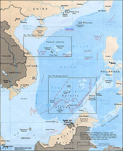
- The Spratly IslandsSpratly IslandsThe Spratly Islands are a group of more than 750 reefs, islets, atolls, cays and islands in the South China Sea. The archipelago lies off the coasts of the Philippines and Malaysia , about one third of the way from there to southern Vietnam. They comprise less than four square kilometers of land...
- The Paracel IslandsParacel IslandsThe Paracel Islands, also called Xisha Islands in Chinese and Hoàng Sa Islands in Vietnamese, is a group of islands under the administration of Hainan Province, The People's Republic of China. Vietnam and the Republic of China also claim sovereignty of these islands...
- The Pratas IslandsPratas IslandsThe Pratas Islands or Dongsha Islands consists of three islands forming from an atoll located in northeastern South China Sea, southeast of Hong Kong. The islands are governed by the Republic of China . The People's Republic of China claims sovereignty over these islands along with all other...
- The Macclesfield BankMacclesfield BankMacclesfield Bank or Zhongsha Islands is an elongated sunken atoll of underwater reefs and shoals in the South China Sea and part of the disputed South China Sea Islands, centred around , east of the Paracel Islands. Its length exceeds southwest-northeast, with a maximal width of more than...
- The Scarborough ShoalScarborough ShoalScarborough Shoal or Scarborough Reef , more correctly described as a group of islands and reefs in an atoll shape than a shoal, is located between the Macclesfield Bank and Luzon, Philippines in the South China Sea. As with most of the landforms in this sea, the sovereignty of the area is disputed...
The Spratly Islands spread over an 810 by 900 km area covering some 175 identified insular features, the largest being Taiping Island (Itu Aba) at just over 1.3 km long and with its highest elevation at 3.8 metres.
The largest singular feature in the area of the Spratly Islands is a 100 km wide seamount
called Reed Tablemount, also known as Reed Bank, in the northeast of the group, separated from Palawan
Island of the Philippines
by the Palawan Trench. Now completely submerged, with a depth of 20 m, it was an island until it sank about 7,000 years ago due to the increasing sea level after the last ice age
. With an area of 8,866 km², it is one of the largest submerged atoll
structures of the world.
Resources
It is an extremely significant body of water in a geopolitical sense. It is the second most used sea lanein the world, while in terms of world annual merchant fleet tonnage, over 50% passes through the Strait of Malacca
, the Sunda Strait
, and the Lombok Strait
. Over 1.6 million m³ (10 million barrels) of crude oil a day are shipped through the Strait of Malacca
, where there are regular reports of piracy
, but much less frequently than before the mid-20th century.
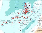
The region has proven oil
reserves of around 1.2 km³ (7.7 billion barrels
), with an estimate of 4.5 km³ (28 billion barrels) in total. Natural gas
reserves are estimated to total around 7,500 km³ (266 trillion cubic feet).
According to studies made by the Department of Environment and Natural Resources, Philippines, this body of water holds one third of the entire world's marine biodiversity, thereby making it a very important area for the ecosystem.
Territorial claims
Both People's Republic of China
(PRC) and the Republic of China
(ROC) claim almost the entire body as their own, demarcating their claims within what is known as the nine-dotted line
, which claims overlap with virtually every other country in the region. Competing claims include:
- Indonesia, China, and Taiwan over waters NE of the Natuna IslandsNatuna IslandsThe Natuna Islands archipelago is located in the Natuna Sea in the larger Tudjuh Archipelago, off the northwest coast of Borneo. The islands are administratively part of the Riau Islands province of Indonesia and are the northernmost non-disputed island group of Indonesia...
- The Philippines, China, and Taiwan over the Malampaya and Camago gas fields.
- The Philippines, China, and Taiwan over Scarborough ShoalScarborough ShoalScarborough Shoal or Scarborough Reef , more correctly described as a group of islands and reefs in an atoll shape than a shoal, is located between the Macclesfield Bank and Luzon, Philippines in the South China Sea. As with most of the landforms in this sea, the sovereignty of the area is disputed...
. - Vietnam, China, and Taiwan over waters west of the Spratly IslandsSpratly IslandsThe Spratly Islands are a group of more than 750 reefs, islets, atolls, cays and islands in the South China Sea. The archipelago lies off the coasts of the Philippines and Malaysia , about one third of the way from there to southern Vietnam. They comprise less than four square kilometers of land...
. Some or all of the islands themselves are also disputed between Vietnam, China, Taiwan, Brunei, Malaysia, and the Philippines. - The Paracel IslandsParacel IslandsThe Paracel Islands, also called Xisha Islands in Chinese and Hoàng Sa Islands in Vietnamese, is a group of islands under the administration of Hainan Province, The People's Republic of China. Vietnam and the Republic of China also claim sovereignty of these islands...
are disputed between the PRC/ROC and Vietnam. - Malaysia, Cambodia, Thailand and Vietnam over areas in the Gulf of ThailandGulf of ThailandThe Gulf of Thailand , also known in to Malays as Teluk Siam literally meant Gulf of Siam, is a shallow arm of the South China Sea.-Geography:...
. - Singapore and Malaysia along the Strait of Johore and the Strait of Singapore.
China and Vietnam have both been vigorous in prosecuting their claims. The People's Republic of China and South Vietnam each controlled part of the Paracel Islands before 1974. A brief conflict in 1974 resulted in 18 soldiers being killed, and China has controlled the whole of Paracel since then. The Spratly Islands
have been the site of a naval clash, in which over seventy Vietnamese sailors were killed just south of Chigua Reef in March 1988. Disputing claimants regularly report clashes between naval vessels.
ASEAN in general, and Malaysia in particular, has been keen to ensure that the territorial disputes within the South China Sea do not escalate into armed conflict. As such, Joint Development Authorities have been set up in areas of overlapping claims to jointly develop the area and dividing the profits equally without settling the issue of sovereignty over the area. This is true, particularly in the Gulf of Thailand. Generally, China has preferred to resolve competing claims bi-laterally, while ASEAN countries prefer multi-lateral talks, believing that they are disadvantaged in bi-lateral negotiations with the much larger China and that because many countries claim the same territory only multilateral talks could effectively resolve the competing claims.
The overlapping claims over Pedra Branca or Pulau Batu Putih including neighboring Middle Rocks by both Singapore and Malaysia were settled in 2008 by the International Court of Justice
, awarding Pedra Branca/Pulau Batu Puteh to Singapore and Middle Rocks to Malaysia.
In July 2010, US Secretary of State Hillary Clinton called for the Peoples Republic of China to resolve the territorial dispute. China responded by demanding the US keep out of the issue. This came at a time when both countries have been engaging in naval exercises in a show of force to the opposing side, which increased tensions in the region. The US Department of Defense released a statement on August 18 where it opposed the use of force to resolve the dispute, and accused China of assertive behaviour.
Chinese objection to Indian naval presence and oil exploration
On July 22, 2011, one of India's amphibious assault vessels, the INS Airavat which was on a friendly visit to Vietnam, was reportedly contacted at a distance of 45 nautical miles from the Vietnamese coast in the disputed South China Sea, was contacted on open radio channel identifying itself as the Chinese Navy and stating that the ship was entering Chinese waters. The spokesperson for the Indian Navy clarified that as no ship or aircraft was visible from INS Airavat it proceeded on her onward journey as scheduled. The Indian Navy further clarified that "[t]here was no confrontation involving the INS Airavat. India supports freedom of navigation in international waters, including in the South China Sea, and the right of passage in accordance with accepted principles of international law. These principles should be respected by all."
In September 2011, shortly after China and Vietnam had signed an agreement seeking to contain a dispute over the South China Sea, India's state-run explorer, Oil and Natural Gas Corporation (ONGC) said that its overseas investment arm ONGC Videsh Limited had signed a three-year deal with PetroVietnam
for developing long-term cooperation in the oil sector and that it had accepted Vietnam's offer of exploration in certain specified blocks in the South China Sea. In response, Chinese Foreign Ministry spokesperson Jiang Yu, without referring to India by name, stated as follows: “China enjoys indisputable sovereignty over the South China Sea and the island. China's stand is based on historical facts and international law. China's sovereign rights and positions are formed in the course of history and this position has been held by Chinese Government for long. On the basis of this China is ready to engage in peaceful negotiations and friendly consultations to peacefully solve the disputes over territorial sovereignty and maritime rights so as to positively contribute to peace and tranquillity in the South China Sea area. We hope that the relevant countries respect China's position and refrain from taking unilateral action to complicate and expand the issue. We hope they will respect and support countries in the region to solve the bilateral disputes through bilateral channels. As for oil and gas exploration activities, our consistent position is that we are opposed to any country engaging in oil and gas exploration and development activities in waters under China's jurisdiction. We hope the foreign countries do not get involved in South China Sea dispute.” The spokesman of the Ministry of External Affairs of the Government of India responded by saying that “The Chinese had concerns but we are going by what the Vietnamese authorities have told us and have conveyed this to the Chinese.” The Indo-Vietnamese deal was also denounced by the Chinese state-run newspaper Global Times.
South China Sea in astronomy
South China Sea is associated with the star Xi Serpentisin asterism Left Wall, Heavenly Market enclosure
(see Chinese constellation
).
See also
- East China SeaEast China SeaThe East China Sea is a marginal sea east of China. It is a part of the Pacific Ocean and covers an area of 1,249,000 km² or 750,000 square miles.-Geography:...
- South China Sea shipwrecksSouth China Sea shipwrecksThe South China Sea shipwrecks are two shipwrecks discovered in the South China Sea. The shipwrecks may yield important archaeological evidence about the marine Silk Road trade route linking ancient China with the Western world....
- Territorial disputes in South China Sea
Further reading
- Clive Schofield et al., From Disputed Waters to Seas of Opportunity: Overcoming Barriers to Maritime Cooperation in East and Southeast Asia (July 2011)
- C.Michael Hogan (2011) South China Sea Topic ed. P.Saundry. Ed.-in-chief C.J.Cleveland. Encyclopedia of Earth. National Council for Science and the Environment. Washington DC
- UNEP (2007). Review of the Legal Aspects of Environmental Management in the South China Sea and Gulf of Thailand. UNEP/GEF/SCS Technical Publication No. 9.
- Keyan Zou (2005). Law of the sea in East Asia: issues and prospects. London/New York: Rutledge Curzon. ISBN 0-415-35074-3
External links
- Rising Tensions in the South China Sea, June 2011 Q&A with Ian J. Storey
- News collections on The South China Sea on China Digital TimesChina Digital TimesChina Digital Times is a bilingual "collaborative news website covering China’s social and political transition and its emerging role in the world," according to the site's About page...
- The South China Sea on Google Earth - featured on Google Earth's Official Blog
- South China Sea Virtual Library - online resource for students, scholars and policy-makers interested in South China Sea regional development, environment, and security issues.
- Energy Information Administration - The South China Sea
- Tropical Research and Conservation Centre - The South China Sea
- Weekly Piracy Report
- Reversing Environmental Degradation Trends in the South China Sea and Gulf of Thailand
- UNEP/GEF South China Sea Knowledge Documents