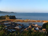
See Also

Palawan

Palawan is an island Island

An island or isle is any piece of land that is completely surrounded by water.... 

 province Provinces of the Philippines

||- | |} The province is the primary local government unit in the Philippines [i]. ... 

 of the Philippines Philippines

The Philippines , officially the Republic of the Philippines , is an island nation [i] located in ... 

 located in the Southern Tagalog Southern Tagalog

Southern Tagalog, or Region IV, was a region [i] of the Philippines [i] ... 

 region Regions of the Philippines

A region is an administrative subdivision in the Philippines [i]. ... 

. Its capital is Puerto Princesa City Puerto Princesa City

The City of Puerto Princesa is a first class city [i] in the province [i] ... 

 and it is the largest province in terms of land area. The islands of Palawan stretches from Mindoro Mindoro

Mindoro is the seventh-largest island in the Philippines [i]. ... 

 to Borneo Borneo

Borneo is the third largest island in the world [i]. ... 

 in the southwest. It lies between the South China Sea South China Sea

The South China Sea is a marginal sea [i] south of China [i]. ... 

 in the northwest and Sulu Sea in the southeast. The province is named after its largest island, Palawan Island.

Discussions

  Discussion Features

   Ask a question about 'Palawan'

   Start a new discussion about 'Palawan'

   Answer questions about 'Palawan'

   'Palawan' discussion forum

Timeline

1934   Pearl of Lao Tzu, 24 x 14 cm, is found in a giant clam Giant clam

The giant clam or traditionally, paua, is the largest living bivalve [i] mollusc [i]. ... 

 off Palawan, Philippines Philippines

The Philippines , officially the Republic of the Philippines , is an island nation [i] located in ... 

.

2002   Philippino actor Rico Yan is found dead inside his cottage in a resort in Palawan.


Encyclopedia

Palawan is an island Island

An island or isle is any piece of land that is completely surrounded by water.... 

 province Provinces of the Philippines

||-
|
|}
The province is the primary local government unit in the Philippines [i]. ... 

 of the Philippines Philippines

The Philippines , officially the Republic of the Philippines , is an island nation [i] located in ... 

 located in the Southern Tagalog Southern Tagalog

Southern Tagalog, or Region IV, was a region [i] of the Philippines [i] ... 

 region Regions of the Philippines

A region is an administrative subdivision in the Philippines [i]. ... 

. Its capital is Puerto Princesa City Puerto Princesa City

The City of Puerto Princesa is a first class city [i] in the province [i] ... 

 and it is the largest province in terms of land area. The islands of Palawan stretches from Mindoro Mindoro

Mindoro is the seventh-largest island in the Philippines [i]. ... 

 to Borneo Borneo

Borneo is the third largest island in the world [i].... 

 in the southwest. It lies between the South China Sea South China Sea

The South China Sea is a marginal sea [i] south of China [i]. ... 

 in the northwest and Sulu Sea in the southeast.

The province is named after its largest island, Palawan Island.

People and culture

Palawan is a melting pot of 87 different cultural groups and races. Basically, the people are of Malay origin, with sprinkling of Chinese and Spanish bloodlines. Its culture has a strong influence from Borneo, China and the Middle East. Influx of migrants from other parts of the Philippines accounts for the high population growth rate of 3.98% annually. Eighteen percent of the population is composed of cultural minority groups such as Tagbanua, Pinalawan, Batak, Ken-uy , Calamian, Jama-Mapuns, Molbog, Tausug and Samal-Bangingi.

Economy


Geography


Ecotourism


Palawan is considered to be the Philippines' "last frontier". The province boasts of many splendid beaches and has two World Heritage Site World Heritage Site

A UNESCO World Heritage Site is a specific site that has been nominated and confirmed for inclusion on ... 

s: Tubbataha Reef National Marine Park and the Puerto Princesa Subterranean River National Park.


Political

Palawan is subdivided into 23 municipalities and 1 city.

The Philippine government claims most of the Spratly Islands Spratly Islands

The Spratly Islands are a disputed group of approximately 100 reefs [i] and islets [i] in the South China Sea [i] ... 

, locally called the Kalayaan Group of Islands, in the South China Sea Islands to be under the jurisdiction of Palawan.
Religion
The predominant religion in Palawan is Roman Catholicism Roman Catholic Church

The Roman Catholic Church or Catholic Church is the Christian [i] Church [i] ... 

. Pockets of Muslims Muslim

A Muslim is an adherent of Islam [i]. ... 

 can be found in the southern municipalities with Muslims making up the majority of the population in some municipalities in the far south like Balabac and Bataraza Bataraza, Palawan

Bataraza is a 2nd class municipality [i] in the province [i] ... 

. Members of The Church of Jesus Christ of Latter-day Saints Church of Jesus Christ of Latter-day Saints

The Church of Jesus Christ of Latter-day Saints, widely known as the LDS Church or the Mormon C... 

  have a strong presence on Palawan, as well as the Seventh-Day Adventists Seventh-day Adventist Church

The Seventh-day Adventist Church is a Christian [i] denomination [i] ... 

, Iglesia ni Cristo Iglesia ni Cristo

The Iglesia ni Cristo is an independent, nontrinitarian [i] religious organization tha... 

, Jesus Miracle Crusade Jesus Miracle Crusade

The Jesus Miracle Crusade International Ministry is a religious group from the Philippines which is well... 

 and Protestant religions.

City

  • Puerto Princesa City Puerto Princesa City

    The City of Puerto Princesa is a first class city [i] in the province [i] ... 


Municipalities


*Aborlan Aborlan, Palawan

Aborlan is a 2nd class municipality [i] in the province [i] ... 


*Agutaya Agutaya, Palawan

Agutaya is a 5th class municipality [i] in the province [i] ... 


*Araceli Araceli, Palawan

Araceli is a 5th class municipality [i] in the province [i] ... 


*Balabac Balabac, Palawan

Balabac is a 3rd class municipality [i] in the province [i] ... 


*Bataraza Bataraza, Palawan

Bataraza is a 2nd class municipality [i] in the province [i] ... 


*Brooke's Point Brooke's Point, Palawan

Brooke's Point is a 1st class municipality [i] in the province [i] ... 


*Busuanga Busuanga, Palawan

Busuanga is a municipality [i] in the province [i] of Palawan [i] ... 


*Cagayancillo Cagayancillo, Palawan

Cagayancillo is a 6th class municipality [i] in the province [i] ... 


*Coron Coron, Palawan

Coron is a 2nd class municipality [i] in the province [i] of... 


*Culion Culion, Palawan

Culion is a 4th class municipality [i] in the province [i] o ... 


*Cuyo Cuyo, Palawan

Cuyo is a 4th class municipality [i] in the province [i] of ... 


*Dumaran Dumaran, Palawan

Dumaran is a 4th class municipality [i] in the province [i] ... 


*El Nido El Nido, Palawan

El Nido is a fourth class municipality [i] and marine reserve park in the province [i]... 


*Kalayaan Kalayaan, Palawan

Kalayaan is a 5th class municipality [i] in the province [i] ... 


*Linapacan Linapacan, Palawan

[i] in the [[Philippine province|province]... 


*Magsaysay Magsaysay, Palawan

[i] in the [[Philippine province|province]... 


*Narra Narra, Palawan

Narra is a 1st class municipality [i] in the province [i] of... 


*Quezon Quezon, Palawan

Quezon is a 1st class municipality [i] in the province [i] o ... 


*Rizal Rizal, Palawan

Rizal is a 2nd class municipality [i] in the province [i] of... 


*Roxas Roxas, Palawan

Roxas is a 1st class municipality [i] in the province [i] of... 


*San Vicente San Vicente, Palawan

San Vicente is a 1st class municipality [i] in the province [i] ... 


*Sofronio Española Sofronio Española, Palawan

... 


*Taytay Taytay, Palawan

Taytay is a 1st class municipality [i] in the province [i] o ... 


Physical

Palawan is the Philippine's largest province in terms of total land area. It consists of the long and narrow Palawan Island, plus a number of other smaller islands surrounding the main island. The Calamian Group of Islands, to the northwest consists of Busuanga Island, Culion Island Culion, Palawan

Culion is a 4th class municipality [i] in the province [i] o ... 

, and Coron Island Coron Island

Coron Island, located at the northern tip of Palawan in the Philippines [i], is known for several Japan [i] ... 

. Durangan Island almost touches the westernmost part of Palawan Island, while Balabac Island is located off the southern tip, separated from Borneo Borneo

Borneo is the third largest island in the world [i].... 

 by the Balabac Strait. In addition, Palawan covers the Cuyo Islands and Cagayan Island in the Sulu Sea. The disputed Spratly Islands Spratly Islands

The Spratly Islands are a disputed group of approximately 100 reefs [i] and islets [i] in the South China Sea [i] ... 

, located a few hundred kilometers to the west is considered part of Palawan by the Philippines, and is locally called the Kalayaan Group of Islands.

Palawan's almost 2,000 kilometers of irregular coastline are dotted with 1,780 islands and islets, rocky coves, and sugar-white sandy beaches. It also harbors a vast stretch of virgin forests that carpet its mountain ranges.

Region

Palawan was originally part of the Southern Tagalog Southern Tagalog

Southern Tagalog, or Region IV, was a region [i] of the Philippines [i] ... 

 Region . When the region was split, it became a part of the former MIMAROPA .

Palawan on 2001 rejected by virtue of a referendum to be a part of Autonomous Region in Muslim Mindanao Autonomous Region in Muslim Mindanao

The Autonomous Region in Muslim Mindanao, abbreviated as the ARMM is the region [i] ... 

.

President Gloria Arroyo included Palawan by virtue of Executive Order No. 103, dated May 17, 2002, as part of MIMAROPA .

Palawan was moved to Region VI on May 23, 2005 by virtue of Executive Order 429. However, Palaweños have criticized the move, especially due to a lack of consultation, with most residents in every municipality except one and Puerto Princesa City preferring to stay with Region IV-B than transfer to Region VI.

Administrative Order No. 129 was issued on August 19, 2005, to "resolve" the negative backlash and as part of the supervison of the transfer process of Palawan from MIMAROPA to Western Visayas.

History


Pre-colonial Era

Ancient Chinese traders and waves of migrants arrived in the Philippines by way of land bridges between Borneo and Palawan. A Chinese author referred to these islands as Kla-ma-yan , Palau-ye , and Paki-nung . Pottery, china and other artifacts recovered from caves and waters of Palawan attest to trade relations that existed between Chinese and Malay merchants.

In the 12th century, Malay settlers began to populate the island. Most of the settlements were ruled by Malay chieftains. These people grew palay, ginger, coconuts, camote, sugar and bananas. They also raised pigs, goats and chickens. Most of their economic activities were fishing, farming, and hunting by the use of bamboo traps and blowguns. The local people had a dialect consisting of 18 syllables.

Spanish Rule

The northern Calamianes Islands were the first to come under Spanish authority, and were later declared a province separate from the Palawan mainland. In the early 17th century, Spanish friars sent out missions in Cuyo, Agutaya, Taytay and Cagayancillo but they met resistance from Moro communities. Before 18th century, Spain began to build churches enclosed by garrisons for protection against Moro raids in the town of Cuyo, Taytay, Linapacan and Balabac. In 1749, the Sultanate of Borneo ceded southern Palawan to Spain.

At first, the territory of Palawan was organized as a single province named Calamianes, with its capital in Taytay. Later, it was divided into three provinces: Castilla covering the northern section of the province with Taytay as capital, Asturias in the southern mainland with Puerto Princesa as capital, and Balabac Island with its capital in the town of Principe Alfonso.

American Rule

When the Spaniards left after the 1898 revolution, a civil government was established by the Americans. Provincial boundaries were revised in 1903, the name of the province was changed to Palawan, and Puerto Princesa declared as its capital.

Many reforms and projects were later introduced in the province. Construction of school buildings, promotion of agriculture, and bringing people closer to the government were among the priority plans during this era.

Palawan Massacre


During World War II, in order to prevent the rescue of prisoners of war by the advancing allies, on 14 December 1944, the Japanese herded the remaining 150 POWs at Puerto Princesa into three covered trenches which were then set on fire using barrels of gasoline. As prisoners tried to escape the flames they were shot down. Some escaped by going over a cliff that ran along one side of the trenches, but were later hunted down and killed. Only 11 men escaped the slaughter and between 133 to 141 were killed. The site of the massacre can still be visited. The massacre is the premise of the recently published book "Last Man Out: Glenn McDole, USMC, Survivor of the Palawan Massacre in World War II" by Bob Wilbanks, and the opening scenes of the 2005 Miramax movie, "The Great Raid".

Honda Bay Kidnappings


In May 2001 Palawan hit the headlines when the militant Islamic group Abu Sayyaf Abu Sayyaf

The Abu Sayyaf Group , also known as al-Harakat al-Islamiyya is a militant [i] Islamist [i] ... 

 abducted 20 guests from the Dos Palmas Resort, located in Honda Bay outside of Puerto Princesa City. The kidnapping raid led to a massive U.S.-backed security operation, and unfortunately two hostages were later killed. Significantly, there have been no repeat incidents of this kind in Palawan, and the combination of a beefed-up military presence and radar surveillance has considerably boosted security. Basically, Palawan is a safe place to visit.

Is Famous For


Calauit Game Preserve & Wildlife Sanctuary.

  • It is a unique game reserve and wildlife sanctuary of exotic African animals and endangered endemic animals of Palawan.
  • Established on August 31,1976 by virtue of Presidential Decree No.1578, this was initiated in response to the appeal of the International Union for the Conservation of Nature to help save African wildlife when former President Ferdinand Marcos attended the 3rd world Conference in Kenya. By virtue of RA 7611 , administrative jurisdiction of DENR was given to the local government of Palawan, effective December 31,1993. Management of the area is the responsibility of the PCSDO . It is located in Calauit Island, Busuanga, Palawan.


Coron Reefs, Coron Bay, Busuanga.

  • Seven enchanting lakes surrounded by craggy limestone cliffs attract hundreds of nature lovers to Coron Reefs in Northern Palawan, near the town of Coron.
  • Busuanga Island, whose main town is Coron, is the jump-off point for numerous dive operators. The principal dive sites are 12 WWII Japanese shipwrecks sunk on September 24, 1944 by US Navy action. They range in depth from the surface to 40M. This large variety offers exciting wreck exploration for enthusiasts, from novice divers and snorkelers and recreational divers to experienced TEC divers. Dive operators offer PADI dive courses ranging from Discover Scuba to Assistant Instructor, Technical and Enriched Air Diving, as well as other specialty courses. Dive operators offer day diving, snorkeling trips, and overnight dive safaris. Live-aboard and charter boats also offer diving in the area.


El Nido Marine Reserve Park

UNESCO WORLD HERITAGE SITES:

Puerto-Princesa Subterranean River National Park 1999

This park features a spectacular limestone karst landscape with an underground river. One of the river's distinguishing features is that it emerges directly into the sea, and its lower portion is subject to tidal influences. The area also represents a significant habitat for biodiversity conservation. The site contains a full 'mountain-to-sea' ecosystem and has some of the most important forests in Asia.
-UNESCO

Tubbataha Reef Marine Park 1993

The Tubbataha Reef Marine Park covers 332 km², including the North and South Reefs. It is a unique example of an atoll reef with a very high density of marine species; the North Islet serveing as a nesting site for birds and marine turtles. The site is an excellent example of a pristine coral reef with a spectacular 100 m perpendicular wall, extensive lagoons and two coral islands. -UNESCO

External links