
Pasig River
Encyclopedia
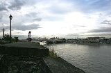
The Pasig River is a river
in the Philippines
that connects Laguna de Bay
to Manila Bay
. Stretching for 25 kilometres (15.5 mi), it is lined by Metro Manila
on each side. Its major tributaries are the Marikina River
and San Juan River
.
The Pasig River is technically a tidal estuary, as the flow direction depends upon the water-level difference between Manila Bay and Laguna de Bay. During the dry season
, the water level in Laguna de Bay
is low and the flow direction of the Pasig River depends on the tides. During the wet season
, when the water level of Laguna de Bay is high, flow is normally from Laguna de Bay towards Manila Bay.
The Pasig River used to be an important transport route in Spanish Manila
. Due to negligence and industrial development, the river has become very polluted
and is considered dead (unable to sustain life) by ecologists. The Pasig River Rehabilitation Commission
(PRRC) was established to oversee rehabilitation efforts for the river. Supporting the PRRC are private sector organizations, i.e. Clean and Green Foundation, Inc. that implemented the Piso para sa Pasig (Filipino: A peso for the Pasig) campaign.
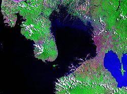
, the largest lake in the Philippines, to Manila Bay
, in the southern part of the island of Luzon
. From the lake, the river runs between Taguig City
, and Taytay, Rizal
, before entering Pasig City
. This portion of the Pasig River, to the confluence with the Marikina River
tributary, is known as the Napindan River or Napindan Channel. From there, the river forms the common border between Makati City
to the south and Pasig City, followed by Mandaluyong City
to the north. The river then sharply turns northeast, where it has become the border between Mandaluyong and Manila
before turning again westward, joining its other major tributary, the San Juan River
, and then following a sinuous path through the center of Manila before emptying into the bay.
The whole river and most portions of its tributaries lie entirely within Metro Manila
, the metropolitan region of the capital. Isla de Convalescencia (14°35′26"N 120°59′20"E), the only island dividing the Pasig River, can be found in Manila and it is where the Hospicio de San Jose
is located.
, which enters into Taguig before becoming the Pateros River; it is the border between the municipalities of Pateros
and Makati City. Pateros River then enters the confluence
where the Napindan River and Marikina River meet. The Marikina River is the larger of the two major tributaries of the Pasig River, and it flows southward from the mountains of Rizal
and cuts through the Marikina Valley. The San Juan River drains the plateau on which Quezon City
stands; its major tributary is Diliman Creek.
Within the city of Manila, various esteros (canals) criss-cross through the city and connect with the Tullahan River
in the north and the Parañaque River
to the west
s cross the river. The first bridge from the source at the Laguna de Bay
is the Napindan Bridge, followed by the Arsenio Jimenez Bridge. Crossing the Napindan Channel in Pasig is the Bambang Bridge. Downstream is the C-5 Road Bridge connecting the cities of Makati and Pasig. The Guadalupe Bridge between Makati and Mandaluyong carries Epifanio de los Santos Avenue
, the major highway of Metro Manila, as well as the Blue Line (Line 3) of the Metro Rail Transit
(MRT). The Rockwell Bridge and Makati
-Mandaluyong
Boundary Bridge are another bridges that connect the two cities downstream and forms the end of Makati Avenue.
The easternmost bridge in Manila is the Lambingan Bridge in the district of Sta. Ana
, followed by the Padre Zamora (Pandacan) Bridge between Pandacan
and Santa Mesa
, which also carries the southern line of the Philippine National Railways
(PNR). The Mabini Bridge (formerly Nagtahan Bridge) provides a crossing for Nagtahan Avenue, part of the C-2 Road. Ayala Bridge carries Ayala Boulevard and connects Isla de Convalescencia to both banks. Further downstream are the Quezon Bridge
from Quiapo
to Ermita
, the LRT
Yellow Line (Line 1) bridge from Central Terminal Station
to Carriedo Station
, MacArthur Bridge from Divisoria to Ermita
, and the Jones Bridge
from Binondo
to Ermita
. The last bridge near the mouth of Pasig River is the Roxas Bridge from Tondo
to Port Area, formerly known as the Del Pan Bridge.
, an orphanage located on Pasig's sole island, the Isla de Convalescencia. On the northern bank stands Malacañang Palace
, the official residence of the President of the Philippines
.
Also on Pasig River's northern bank and within the Manila district of Sta. Mesa
is the main campus of the Polytechnic University of the Philippines
.
In Makati City, along the southern bank of Pasig, is the Sta. Ana Racetrack and the Rockwell Commercial Center, a high-end office and commercial area containing the Power Plant Mall. At the confluence of the Pasig and Marikina rivers is the Napindan Hydraulic Control Structure, which regulates the flow of water from the Napindan Channel.
 The Pasig River's main watershed is concentrated in the plains between Manila Bay
and Laguna de Bay
. The watershed of the Marikina River
tributary mostly occupies the Marikina Valley, which was formed by the Marikina Fault Line
. The Manggahan Floodway
is an artificially constructed waterway that aims to reduce the flooding in the Marikina Valley during the rainy season, by bringing excess water to the Laguna de Bay.
, the water level in the lake may drop below that of Manila Bay's, resulting in a reverse flow of seawater from the bay into the lake. This results in increased pollution and salinity levels in Laguna de Bay at this time of the year.
was constructed to divert excess floodwater from the Marikina River into the Laguna de Bay, which serves as a temporary reservoir. By design, the Manggahan Floodway is capable of handling 2,400 cubic meters per second of water flow, although the actual flow is about 2,000 cubic meters per second. To complement the floodway, the Napindan Hydraulic Control System (NHCS) was built in 1983 at the confluence of the Marikina River and the Napindan Channel to regulate the flow of water between the Pasig River and the lake.
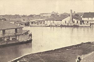 Before the mass urbanization of Manila, the Pasig River served as an important means of transport; it was the city's lifeline and center of economic activity. Some of the most prominent kingdoms in early Philippine history
, including the kingdoms of Namayan, Maynila
, and Tondo grew up along the banks of the river, drawing their life and source of wealth from it. When the Spanish established Manila as the capital of their colonial properties in the Far East, they built the walled city of Intramuros on the southern bank of Pasig River near its mouth.
, massive population growth, infrastructure construction, and the dispersal of economic activities to Manila's suburbs left the river neglected. The banks of the river attracted informal settlers and the remaining factories dumped their wastes into the river, making it effectively a huge sewer system. Industrialization had already polluted the river.
In the 1930s, observers noticed the increasing pollution of the river, as fish migration from Laguna de Bay diminished. People ceased using the river's water for laundering in the 1960s, and ferry transport declined. By the 1970s, the river started to emanate offensive smells, and in the 1980s, fishing in the river was prohibited. By the 1990s, the Pasig River was considered biologically dead
authorities. The Pasig River Rehabilitation Program (PRRP) was established, with the Department of Environment and Natural Resources
as the main agency with the coordination of the Danish International Development Assistance (DANIDA).
In 1999, President Joseph Estrada
signed Executive Order No. 54 establishing the PRRC to replace the old PRRP with additional expanded powers such as managing of wastes and resettling of squatters.
River
A river is a natural watercourse, usually freshwater, flowing towards an ocean, a lake, a sea, or another river. In a few cases, a river simply flows into the ground or dries up completely before reaching another body of water. Small rivers may also be called by several other names, including...
in the Philippines
Philippines
The Philippines , officially known as the Republic of the Philippines , is a country in Southeast Asia in the western Pacific Ocean. To its north across the Luzon Strait lies Taiwan. West across the South China Sea sits Vietnam...
that connects Laguna de Bay
Laguna de Bay
Laguna de Bay is the largest lake in the Philippines and the third largest freshwater lake in Southeast Asia after Tonle Sap in Cambodia and Lake Toba in Sumatra, Indonesia. It is on the island of Luzon between the provinces of Laguna to the south and Rizal to the north...
to Manila Bay
Manila Bay
Manila Bay is a natural harbor which serves the Port of Manila , in the Philippines.The bay is considered to be one of the best natural harbors in Southeast Asia and one of the finest in the world...
. Stretching for 25 kilometres (15.5 mi), it is lined by Metro Manila
Metro Manila
Metropolitan Manila , the National Capital Region , or simply Metro Manila, is the metropolitan region encompassing the City of Manila and its surrounding areas in the Philippines...
on each side. Its major tributaries are the Marikina River
Marikina River
The San Mateo - Marikina River is a main river system in Eastern Metro Manila, Philippines. A river stretching from Rodriguez, Rizal, to Pasig City that connects to Pasig River as major tributary near Napindan Area in Pasig City.San Mateo - Marikina River used to be an important transport route...
and San Juan River
San Juan River (Metro Manila)
The San Juan River is one of the main river system in Metro Manila, Philippines, and is a major tributary of the Pasig River. It begins near La Mesa Dam as the San Francisco River, which officially takes on the name San Juan River when it meets with Mariblo Creek in Quezon City...
.
The Pasig River is technically a tidal estuary, as the flow direction depends upon the water-level difference between Manila Bay and Laguna de Bay. During the dry season
Dry season
The dry season is a term commonly used when describing the weather in the tropics. The weather in the tropics is dominated by the tropical rain belt, which oscillates from the northern to the southern tropics over the course of the year...
, the water level in Laguna de Bay
Laguna de Bay
Laguna de Bay is the largest lake in the Philippines and the third largest freshwater lake in Southeast Asia after Tonle Sap in Cambodia and Lake Toba in Sumatra, Indonesia. It is on the island of Luzon between the provinces of Laguna to the south and Rizal to the north...
is low and the flow direction of the Pasig River depends on the tides. During the wet season
Wet season
The the wet season, or rainy season, is the time of year, covering one or more months, when most of the average annual rainfall in a region occurs. The term green season is also sometimes used as a euphemism by tourist authorities. Areas with wet seasons are dispersed across portions of the...
, when the water level of Laguna de Bay is high, flow is normally from Laguna de Bay towards Manila Bay.
The Pasig River used to be an important transport route in Spanish Manila
Manila
Manila is the capital of the Philippines. It is one of the sixteen cities forming Metro Manila.Manila is located on the eastern shores of Manila Bay and is bordered by Navotas and Caloocan to the north, Quezon City to the northeast, San Juan and Mandaluyong to the east, Makati on the southeast,...
. Due to negligence and industrial development, the river has become very polluted
Pollution
Pollution is the introduction of contaminants into a natural environment that causes instability, disorder, harm or discomfort to the ecosystem i.e. physical systems or living organisms. Pollution can take the form of chemical substances or energy, such as noise, heat or light...
and is considered dead (unable to sustain life) by ecologists. The Pasig River Rehabilitation Commission
Pasig River Rehabilitation Commission
The Pasig River Rehabilitation Commission is a state commission in charged of the rehabilitation of Pasig River. The body was created on January of 1999 through Executive Order 54 to strengthen the government's program to rehabilitate the river for transportation, recreation and tourism purposes...
(PRRC) was established to oversee rehabilitation efforts for the river. Supporting the PRRC are private sector organizations, i.e. Clean and Green Foundation, Inc. that implemented the Piso para sa Pasig (Filipino: A peso for the Pasig) campaign.
Geography
The Pasig River winds generally north-westward for some 25 kilometres (15.5 mi) from the Laguna de BayLaguna de Bay
Laguna de Bay is the largest lake in the Philippines and the third largest freshwater lake in Southeast Asia after Tonle Sap in Cambodia and Lake Toba in Sumatra, Indonesia. It is on the island of Luzon between the provinces of Laguna to the south and Rizal to the north...
, the largest lake in the Philippines, to Manila Bay
Manila Bay
Manila Bay is a natural harbor which serves the Port of Manila , in the Philippines.The bay is considered to be one of the best natural harbors in Southeast Asia and one of the finest in the world...
, in the southern part of the island of Luzon
Luzon
Luzon is the largest island in the Philippines. It is located in the northernmost region of the archipelago, and is also the name for one of the three primary island groups in the country centered on the Island of Luzon...
. From the lake, the river runs between Taguig City
Taguig City
Taguig is a city in Metro Manila in the Philippines. From a thriving fishing community along the shores of Laguna de Bay, it is now an important residential, commercial and industrial center...
, and Taytay, Rizal
Taytay, Rizal
The Municipality of Taytay is a first class, urban municipality in the province of Rizal, Philippines. It is currently the third second most populous town in Rizal after and Cainta. Taytay serves a the gateway of West Rizal to the cities of Pasig and Taguig...
, before entering Pasig City
Pasig City
The City of Pasig is one of the city municipalities of Metro Manila in the Philippines and was the former capital of the province of Rizal prior to the formation of this grouping of cities designated as the National Capital Region...
. This portion of the Pasig River, to the confluence with the Marikina River
Marikina River
The San Mateo - Marikina River is a main river system in Eastern Metro Manila, Philippines. A river stretching from Rodriguez, Rizal, to Pasig City that connects to Pasig River as major tributary near Napindan Area in Pasig City.San Mateo - Marikina River used to be an important transport route...
tributary, is known as the Napindan River or Napindan Channel. From there, the river forms the common border between Makati City
Makati City
The City of Makati is one of the 17 cities that make up Metro Manila, one of the most populous metropolitan areas in the world. Makati is the financial center of the Philippines and one of the major financial, commercial and economic hubs in Asia...
to the south and Pasig City, followed by Mandaluyong City
Mandaluyong City
The City of Mandaluyong is one of the cities and municipalities that comprise Metro Manila in the Philippines. It is bordered on the west by the country's capital, Manila, to the north by San Juan City, to the east by Quezon City and Pasig City, and by Makati City to the south...
to the north. The river then sharply turns northeast, where it has become the border between Mandaluyong and Manila
Manila
Manila is the capital of the Philippines. It is one of the sixteen cities forming Metro Manila.Manila is located on the eastern shores of Manila Bay and is bordered by Navotas and Caloocan to the north, Quezon City to the northeast, San Juan and Mandaluyong to the east, Makati on the southeast,...
before turning again westward, joining its other major tributary, the San Juan River
San Juan River (Metro Manila)
The San Juan River is one of the main river system in Metro Manila, Philippines, and is a major tributary of the Pasig River. It begins near La Mesa Dam as the San Francisco River, which officially takes on the name San Juan River when it meets with Mariblo Creek in Quezon City...
, and then following a sinuous path through the center of Manila before emptying into the bay.
The whole river and most portions of its tributaries lie entirely within Metro Manila
Metro Manila
Metropolitan Manila , the National Capital Region , or simply Metro Manila, is the metropolitan region encompassing the City of Manila and its surrounding areas in the Philippines...
, the metropolitan region of the capital. Isla de Convalescencia (14°35′26"N 120°59′20"E), the only island dividing the Pasig River, can be found in Manila and it is where the Hospicio de San Jose
Hospicio de San Jose
The Hospicio de San Jose is a Catholic welfare institution in the Philippines. It is the first social welfare agency in the Philippines and has been a home to orphans, abandoned and special children, and elderly....
is located.
Tributaries and canals
One major river that drains Laguna de Bay is the Taguig RiverTaguig River
The Taguig River is a river of the Philippines, a tributary of the Pasig River. It eventually joins the Pateros River, forming the common border between the municipality of Pateros and Makati City.-External links:*...
, which enters into Taguig before becoming the Pateros River; it is the border between the municipalities of Pateros
Pateros, Metro Manila
The Municipality of Pateros is a First-class municipality in Metro Manila, Philippines. This small town is famous for its duck-raising industry and especially for producing balut, a Filipino delicacy that is boiled duck egg...
and Makati City. Pateros River then enters the confluence
Confluence
Confluence, in geography, describes the meeting of two or more bodies of water.Confluence may also refer to:* Confluence , a property of term rewriting systems...
where the Napindan River and Marikina River meet. The Marikina River is the larger of the two major tributaries of the Pasig River, and it flows southward from the mountains of Rizal
Rizal
Rizal is a province located in the CALABARZON , just 16 kilometers east of Manila. The province was named after the country's national hero, José Rizal. Rizal Governor Casimiro A. Ynares III on June 17, 2008 announced the transfer of the Capitol from Pasig. Its P 270-million capitol building,...
and cuts through the Marikina Valley. The San Juan River drains the plateau on which Quezon City
Quezon City
Quezon City is the former capital and the most populous city in the Philippines. Located on the island of Luzon, Quezon City is one of the cities and municipalities that make up Metro Manila, the National Capital Region. The city was named after Manuel L...
stands; its major tributary is Diliman Creek.
Within the city of Manila, various esteros (canals) criss-cross through the city and connect with the Tullahan River
Tullahan River
The Tullahan River is a river of the Philippines. It is located to the north of Manila and has an approximate length of 7.6 miles or 15 kilometeres.It also flows through Malabon City and Valenzuela City.-External links:*...
in the north and the Parañaque River
Parañaque River
The Parañaque River is a river of the Philippines. It is located to the south of Metro Manila passes the Pasay City and Parañaque City located near Ninoy Aquino International Airport. This river has a tributuary connects to Manila Bay.-External links:*...
to the west
Bridges
A total of 16 bridgeBridge
A bridge is a structure built to span physical obstacles such as a body of water, valley, or road, for the purpose of providing passage over the obstacle...
s cross the river. The first bridge from the source at the Laguna de Bay
Laguna de Bay
Laguna de Bay is the largest lake in the Philippines and the third largest freshwater lake in Southeast Asia after Tonle Sap in Cambodia and Lake Toba in Sumatra, Indonesia. It is on the island of Luzon between the provinces of Laguna to the south and Rizal to the north...
is the Napindan Bridge, followed by the Arsenio Jimenez Bridge. Crossing the Napindan Channel in Pasig is the Bambang Bridge. Downstream is the C-5 Road Bridge connecting the cities of Makati and Pasig. The Guadalupe Bridge between Makati and Mandaluyong carries Epifanio de los Santos Avenue
Epifanio de los Santos Avenue
Epifanio de los Santos Avenue , formerly known as Highway 54, is the main circumferential road and highway of Metro Manila in the Philippines. It is an important commuting artery between the northern and southern parts of the metropolitan area...
, the major highway of Metro Manila, as well as the Blue Line (Line 3) of the Metro Rail Transit
Manila Metro Rail Transit System
The Metro Rail Transit is Metro Manila's third rapid transit line. It forms part of the Strong Republic Transit System, which includes the Manila Light Rail Transit System. The line operates under the name Metrostar Express and is colored blue on rail maps.The line is located along the Epifanio de...
(MRT). The Rockwell Bridge and Makati
Makati City
The City of Makati is one of the 17 cities that make up Metro Manila, one of the most populous metropolitan areas in the world. Makati is the financial center of the Philippines and one of the major financial, commercial and economic hubs in Asia...
-Mandaluyong
Mandaluyong City
The City of Mandaluyong is one of the cities and municipalities that comprise Metro Manila in the Philippines. It is bordered on the west by the country's capital, Manila, to the north by San Juan City, to the east by Quezon City and Pasig City, and by Makati City to the south...
Boundary Bridge are another bridges that connect the two cities downstream and forms the end of Makati Avenue.
The easternmost bridge in Manila is the Lambingan Bridge in the district of Sta. Ana
Santa Ana, Manila
Santa Ana is a district of the City of Manila in the Philippines, located at the southeast banks of the Pasig River, bounded on the northeast by Mandaluyong City, Makati City to the east, southwest is the Manila district of Paco, and to the west, Pandacan....
, followed by the Padre Zamora (Pandacan) Bridge between Pandacan
Pandacan, Manila
Pandacan is a district of the City of Manila in the Philippines, located south of the banks of the Pasig River and belongs under the 6th congressional district of Manila, divided into thirty eight barangays that includes Zone 90 to Zone 95 and barangays 833 to 872.-Profile:Based on a year 2000...
and Santa Mesa
Santa Mesa, Manila
Santa Mesa is one of the 16 geographical districts of the city of Manila, which is primarily a residential, commercial and educational center. Santa Mesa is bounded by several districts and cities...
, which also carries the southern line of the Philippine National Railways
Philippine National Railways
The Philippine National Railways , or PNR, is a state-owned railway company in the Philippines, operating a single line of track on Luzon. As of 2010, it operates one commuter rail service in Metro Manila and a second in the Bicol Region. PNR restored its intercity service to the Bicol region in 2011...
(PNR). The Mabini Bridge (formerly Nagtahan Bridge) provides a crossing for Nagtahan Avenue, part of the C-2 Road. Ayala Bridge carries Ayala Boulevard and connects Isla de Convalescencia to both banks. Further downstream are the Quezon Bridge
Quezon Bridge
The Puente Colgante, originally called Puente de Claveria, was a suspension bridge that connected the Manila districts of Quiapo and Ermita across the Pasig River in the Philippines. Designed by the Basque engineer Matias Menchacatorre and completed in 1852, it was the first suspension bridge in...
from Quiapo
Quiapo, Manila
Quiapo is a district and city square of Manila. Referred as the "Old Downtown", Quiapo in known for where cheap buys or goods are being sold at rock-bottom prices and was the home of the Quiapo Church, where the feast for the Black Nazarene is held, with over millions of people attending...
to Ermita
Ermita, Manila
Ermita is a district of Manila, Philippines located halfway between Intramuros and Malate.-History:Ermita was founded in the late 16th century...
, the LRT
Manila Light Rail Transit System
The Manila Light Rail Transit System, popularly known as the LRT, is a metropolitan rail system serving the Metro Manila area in the Philippines. Although referred to as a light rail system because it originally used light rail vehicles, it has many characteristics of a rapid transit system, such...
Yellow Line (Line 1) bridge from Central Terminal Station
Central Terminal LRT Station
Central Terminal LRT Station, sometimes called Central or Arroceros LRT Station, is a station on the Manila LRT Yellow Line . Like all other LRT-1 stations, Central Terminal is above-ground. The station is located in Ermita in Manila. The station is so-called because it lies at the center of the...
to Carriedo Station
Carriedo LRT Station
Carriedo LRT Station is a station on the Manila LRT Yellow Line . Like all other LRT-1 stations, Carriedo station is above-ground. The station is located in Santa Cruz in Manila. The station is named after Carriedo Street, which is near the station...
, MacArthur Bridge from Divisoria to Ermita
Ermita, Manila
Ermita is a district of Manila, Philippines located halfway between Intramuros and Malate.-History:Ermita was founded in the late 16th century...
, and the Jones Bridge
Jones Bridge
Jones Bridge is a bridge that spans the Pasig River in the city Philippines connecting the districts of Binondo on Rosario Street with the center of Manila...
from Binondo
Binondo, Manila
Binondo is an enclave in Manila primarily populated by ethnic Chinese living in the Philippines. Chinatown, Manila is the oldest Chinatown in the world, established in 1594. Historically, this was where the Spanish permitted converted sangleys, their indigenous Filipino wives, and their mixed-race...
to Ermita
Ermita, Manila
Ermita is a district of Manila, Philippines located halfway between Intramuros and Malate.-History:Ermita was founded in the late 16th century...
. The last bridge near the mouth of Pasig River is the Roxas Bridge from Tondo
Tondo, Manila
Tondo is a district of Manila, Philippines. The locale has existed prior to the arrival of the Spanish, referred to as "Tundun" in the Laguna Copperplate Inscription. One of the most densely populated areas of land in the world, Tondo is located in the northwest portion of the city and is primarily...
to Port Area, formerly known as the Del Pan Bridge.
Landmarks
The growth of Manila along the banks of the Pasig River has made it a focal point for development and historical events. The foremost landmark on the banks of the river is the walled district of Intramuros, located near the mouth of the river on its southern bank. It was built by the Spanish colonial government in the 16th century. Further upstream is the Hospicio de San JoseHospicio de San Jose
The Hospicio de San Jose is a Catholic welfare institution in the Philippines. It is the first social welfare agency in the Philippines and has been a home to orphans, abandoned and special children, and elderly....
, an orphanage located on Pasig's sole island, the Isla de Convalescencia. On the northern bank stands Malacañang Palace
Malacañang Palace
The Malacañan Palace, commonly known simply as Malacañang, is the official residence and principal workplace of the President of the Philippines. Located at 1000 J. P. Laurel Street, San Miguel, Manila, the house was built in 1750 in Spanish Colonial style. It has been the residence of every...
, the official residence of the President of the Philippines
President of the Philippines
The President of the Philippines is the head of state and head of government of the Philippines. The president leads the executive branch of the Philippine government and is the commander-in-chief of the Armed Forces of the Philippines...
.
Also on Pasig River's northern bank and within the Manila district of Sta. Mesa
Santa Mesa, Manila
Santa Mesa is one of the 16 geographical districts of the city of Manila, which is primarily a residential, commercial and educational center. Santa Mesa is bounded by several districts and cities...
is the main campus of the Polytechnic University of the Philippines
Polytechnic University of the Philippines
The Polytechnic University of the Philippines commonly known as PUP is a public research university in the Philippines. It was founded on October 19, 1904 as the Manila Business School, offering commerce-related courses...
.
In Makati City, along the southern bank of Pasig, is the Sta. Ana Racetrack and the Rockwell Commercial Center, a high-end office and commercial area containing the Power Plant Mall. At the confluence of the Pasig and Marikina rivers is the Napindan Hydraulic Control Structure, which regulates the flow of water from the Napindan Channel.
Geology
Manila Bay
Manila Bay is a natural harbor which serves the Port of Manila , in the Philippines.The bay is considered to be one of the best natural harbors in Southeast Asia and one of the finest in the world...
and Laguna de Bay
Laguna de Bay
Laguna de Bay is the largest lake in the Philippines and the third largest freshwater lake in Southeast Asia after Tonle Sap in Cambodia and Lake Toba in Sumatra, Indonesia. It is on the island of Luzon between the provinces of Laguna to the south and Rizal to the north...
. The watershed of the Marikina River
Marikina River
The San Mateo - Marikina River is a main river system in Eastern Metro Manila, Philippines. A river stretching from Rodriguez, Rizal, to Pasig City that connects to Pasig River as major tributary near Napindan Area in Pasig City.San Mateo - Marikina River used to be an important transport route...
tributary mostly occupies the Marikina Valley, which was formed by the Marikina Fault Line
Valley Fault System
The Valley Fault System and formerly as the Marikina Valley Fault System is a group of dextral strike-slip fault which extends from San Mateo, Rizal to Taguig City on the south; running through the cities of Makati, Marikina, Parañaque, Pasig and Taguig...
. The Manggahan Floodway
Manggahan Floodway
The Manggahan Floodway is an artificially constructed waterway in Metro Manila, the Philippines. The floodway was built in 1986, with the cost of 1.1 billion pesos, in order to reduce the flooding along the Pasig River during the rainy season, by diverting the peak water flows of the Marikina...
is an artificially constructed waterway that aims to reduce the flooding in the Marikina Valley during the rainy season, by bringing excess water to the Laguna de Bay.
Tidal flows
The Pasig River is technically considered a tidal estuary. Toward the end of the summer or dry season (April and May), the water level in Laguna de Bay reaches to a minimum of 10.5 meters. During times of high tideHigh Tide
High Tide was a band formed in 1969 by Tony Hill , Simon House , Peter Pavli and Roger Hadden .-History:...
, the water level in the lake may drop below that of Manila Bay's, resulting in a reverse flow of seawater from the bay into the lake. This results in increased pollution and salinity levels in Laguna de Bay at this time of the year.
Flooding
The Pasig River is vulnerable to flooding in times of very heavy rainfall, with the Marikina River tributary the main source of the floodwater. The Manggahan FloodwayManggahan Floodway
The Manggahan Floodway is an artificially constructed waterway in Metro Manila, the Philippines. The floodway was built in 1986, with the cost of 1.1 billion pesos, in order to reduce the flooding along the Pasig River during the rainy season, by diverting the peak water flows of the Marikina...
was constructed to divert excess floodwater from the Marikina River into the Laguna de Bay, which serves as a temporary reservoir. By design, the Manggahan Floodway is capable of handling 2,400 cubic meters per second of water flow, although the actual flow is about 2,000 cubic meters per second. To complement the floodway, the Napindan Hydraulic Control System (NHCS) was built in 1983 at the confluence of the Marikina River and the Napindan Channel to regulate the flow of water between the Pasig River and the lake.
History
History of the Philippines (900-1521)
The known history of the Philippines is marked by the creation of the Laguna Copperplate Inscription , the first written document found in a Philippine language. The inscription itself identifies the date of its creation as the year 900...
, including the kingdoms of Namayan, Maynila
Kingdom of Maynila
The Kingdom of Seludong , or Maynila, which after colonization became Manila, capital of the Philippines, was one of three major city-states that dominated the area around the upper portion of the Pasig River before the arrival of Spanish colonizers in the 16th century.The early inhabitants of the...
, and Tondo grew up along the banks of the river, drawing their life and source of wealth from it. When the Spanish established Manila as the capital of their colonial properties in the Far East, they built the walled city of Intramuros on the southern bank of Pasig River near its mouth.
Pollution
After World War IIWorld War II
World War II, or the Second World War , was a global conflict lasting from 1939 to 1945, involving most of the world's nations—including all of the great powers—eventually forming two opposing military alliances: the Allies and the Axis...
, massive population growth, infrastructure construction, and the dispersal of economic activities to Manila's suburbs left the river neglected. The banks of the river attracted informal settlers and the remaining factories dumped their wastes into the river, making it effectively a huge sewer system. Industrialization had already polluted the river.
In the 1930s, observers noticed the increasing pollution of the river, as fish migration from Laguna de Bay diminished. People ceased using the river's water for laundering in the 1960s, and ferry transport declined. By the 1970s, the river started to emanate offensive smells, and in the 1980s, fishing in the river was prohibited. By the 1990s, the Pasig River was considered biologically dead
Rehabilitation efforts
Efforts to revive the river began in December 1989 with the help of DanishDenmark
Denmark is a Scandinavian country in Northern Europe. The countries of Denmark and Greenland, as well as the Faroe Islands, constitute the Kingdom of Denmark . It is the southernmost of the Nordic countries, southwest of Sweden and south of Norway, and bordered to the south by Germany. Denmark...
authorities. The Pasig River Rehabilitation Program (PRRP) was established, with the Department of Environment and Natural Resources
Department of Environment and Natural Resources (Philippines)
The Department of Environment and Natural Resources is the executive department of the Philippine government responsible for governing and supervising the exploration, development, utilization, and conservation of the country's natural resources.-History:The Department of Environment and Natural...
as the main agency with the coordination of the Danish International Development Assistance (DANIDA).
In 1999, President Joseph Estrada
Joseph Estrada
Joseph "Erap" Ejercito Estrada was the 13th President of the Philippines, serving from 1998 until 2001. Estrada was the first person in the Post-EDSA era to be elected both to the presidency and vice-presidency.Estrada gained popularity as a film actor, playing the lead role in over 100 films in...
signed Executive Order No. 54 establishing the PRRC to replace the old PRRP with additional expanded powers such as managing of wastes and resettling of squatters.
See also
- 1968 Casiguran earthquake1968 Casiguran earthquakeThe 1968 Casiguran earthquake occurred on August 2, 1968 at a magnitude of 7.3 on the Richter scale. The earthquake's epicenter was located in Casiguran, Quezon...
- Laguna de BayLaguna de BayLaguna de Bay is the largest lake in the Philippines and the third largest freshwater lake in Southeast Asia after Tonle Sap in Cambodia and Lake Toba in Sumatra, Indonesia. It is on the island of Luzon between the provinces of Laguna to the south and Rizal to the north...
- Manila BayManila BayManila Bay is a natural harbor which serves the Port of Manila , in the Philippines.The bay is considered to be one of the best natural harbors in Southeast Asia and one of the finest in the world...
- Marikina RiverMarikina RiverThe San Mateo - Marikina River is a main river system in Eastern Metro Manila, Philippines. A river stretching from Rodriguez, Rizal, to Pasig City that connects to Pasig River as major tributary near Napindan Area in Pasig City.San Mateo - Marikina River used to be an important transport route...
- Pasig River Ferry ServicePasig River Ferry ServiceThe Pasig River Ferry Service, was the only water-based transportation that cruised the Pasig River from Barangay Pinagbuhatan in Pasig City to Intramuros, Manila. The system is owned and operated by a private company, SCC Nautical Transport Services Incorporated...
- San Juan RiverSan Juan River (Metro Manila)The San Juan River is one of the main river system in Metro Manila, Philippines, and is a major tributary of the Pasig River. It begins near La Mesa Dam as the San Francisco River, which officially takes on the name San Juan River when it meets with Mariblo Creek in Quezon City...