

Sunda Strait
Encyclopedia
Strait
A strait or straits is a narrow, typically navigable channel of water that connects two larger, navigable bodies of water. It most commonly refers to a channel of water that lies between two land masses, but it may also refer to a navigable channel through a body of water that is otherwise not...
between the Indonesia
Indonesia
Indonesia , officially the Republic of Indonesia , is a country in Southeast Asia and Oceania. Indonesia is an archipelago comprising approximately 13,000 islands. It has 33 provinces with over 238 million people, and is the world's fourth most populous country. Indonesia is a republic, with an...
n islands of Java and Sumatra
Sumatra
Sumatra is an island in western Indonesia, westernmost of the Sunda Islands. It is the largest island entirely in Indonesia , and the sixth largest island in the world at 473,481 km2 with a population of 50,365,538...
. It connects the Java Sea
Java Sea
The Java Sea is a large shallow sea on the Sunda Shelf. It was formed as sea levels rose at the end of the last ice age. The Java Sea lies between the Indonesian islands of Borneo to the north, Java to the south; Sumatra to the west, and Sulawesi to the east...
to the Indian Ocean
Indian Ocean
The Indian Ocean is the third largest of the world's oceanic divisions, covering approximately 20% of the water on the Earth's surface. It is bounded on the north by the Indian Subcontinent and Arabian Peninsula ; on the west by eastern Africa; on the east by Indochina, the Sunda Islands, and...
. The name comes from the Indonesian term Pasundan, meaning "West Java
West Java
West Java , with a population of over 43 million, is the most populous and most densely populated province of Indonesia. Located on the island of Java, it is slightly smaller in area than densely populated Taiwan, but with nearly double the population...
."
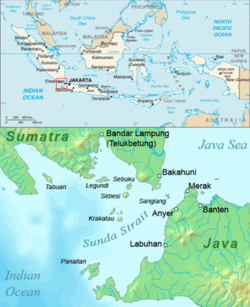
Geography
The strait stretches in a roughly north-east/south-west orientation, with a minimum width of 24 km (14.9 mi) at its north-eastern end between Cape Tua on Sumatra and Cape Pujat on Java. It is very deep at its western end but as it narrows to the east it becomes much shallower, with a depth of only 20 m (65 feet) in parts of the eastern end. This makes it notoriously difficult to navigate, with sandbanks, very strong tidal flows and man-made obstructions such as oil platformOil platform
An oil platform, also referred to as an offshore platform or, somewhat incorrectly, oil rig, is a lаrge structure with facilities to drill wells, to extract and process oil and natural gas, and to temporarily store product until it can be brought to shore for refining and marketing...
s off the Java coast. It has been an important shipping route for centuries, especially during the period when the Dutch East India Company
Dutch East India Company
The Dutch East India Company was a chartered company established in 1602, when the States-General of the Netherlands granted it a 21-year monopoly to carry out colonial activities in Asia...
used it as the gateway to the Spice Islands
Maluku Islands
The Maluku Islands are an archipelago that is part of Indonesia, and part of the larger Maritime Southeast Asia region. Tectonically they are located on the Halmahera Plate within the Molucca Sea Collision Zone...
of Indonesia (1602-1799). The strait's narrowness, shallowness and lack of accurate charting make it unsuitable for many modern large ships, most of which use the Strait of Malacca
Strait of Malacca
The Strait of Malacca is a narrow, stretch of water between the Malay Peninsula and the Indonesian island of Sumatra. It is named after the Malacca Sultanate that ruled over the archipelago between 1414 to 1511.-Extent:...
instead.
The strait is dotted by a number of strait islands, including Sangiang
Sangiang
Sangiang is an island midway in the Sunda Strait between the Indonesian islands of Sumatra and Java. Administratively it is a part of Banten province of western Java. The 2025 plan of Sunda Strait Bridge is going to pass through the island....
(Thwart-the-Way), Sebesi
Sebesi
Sebesi is an Indonesian island in the Sunda Strait, between Java and Sumatra. It rises to a height of and lies about 12 km to the north of the Krakatoa Islands and is the closest large island, about the same area and height as the remmant of Rakata. Like Krakatoa, it too is volcanic, although...
, Sebuku, Panaitan
Panaitan
Panaitan is an island in the Sunda Strait, between Java and Sumatra. It is the largest island in the strait, and is located near the westernmost tip of Java . Like the nearby Krakatoa, it too is volcanic in origin, although there are no known historic eruptions...
(Prince's) and most notably, the Krakatoa Islands: Lang
Lang Island
Lang Island lies in the Sunda Strait, between Java and Sumatra, in Indonesia. It is one of the Krakatoa Islands, near the famous volcano...
(Panjang or Rakata Kecil), Verlaten
Verlaten
Verlaten Island is an island in the Sunda Strait in Indonesia, between Java and Sumatra. It is one of the Krakatoa Islands, near the famous volcano. Other than some minor collapse in the southeast , Verlaten suffered little damage in the 1883 eruption...
(Sertung), Krakatoa
Krakatoa
Krakatoa is a volcanic island made of a'a lava in the Sunda Strait between the islands of Java and Sumatra in Indonesia. The name is used for the island group, the main island , and the volcano as a whole. The island exploded in 1883, killing approximately 40,000 people, although some estimates...
, and Anak Krakatoa. Many of these (including Sebesi
Sebesi
Sebesi is an Indonesian island in the Sunda Strait, between Java and Sumatra. It rises to a height of and lies about 12 km to the north of the Krakatoa Islands and is the closest large island, about the same area and height as the remmant of Rakata. Like Krakatoa, it too is volcanic, although...
and Panaitan
Panaitan
Panaitan is an island in the Sunda Strait, between Java and Sumatra. It is the largest island in the strait, and is located near the westernmost tip of Java . Like the nearby Krakatoa, it too is volcanic in origin, although there are no known historic eruptions...
) are volcanic in origin, but the best known volcano is Krakatoa
Krakatoa
Krakatoa is a volcanic island made of a'a lava in the Sunda Strait between the islands of Java and Sumatra in Indonesia. The name is used for the island group, the main island , and the volcano as a whole. The island exploded in 1883, killing approximately 40,000 people, although some estimates...
. The islands in the strait and the nearby surrounding regions of Java and Sumatra were devastated by the eruption of Krakatoa
Krakatoa
Krakatoa is a volcanic island made of a'a lava in the Sunda Strait between the islands of Java and Sumatra in Indonesia. The name is used for the island group, the main island , and the volcano as a whole. The island exploded in 1883, killing approximately 40,000 people, although some estimates...
in 1883, primarily due to intense pumice fall and huge tsunami
Tsunami
A tsunami is a series of water waves caused by the displacement of a large volume of a body of water, typically an ocean or a large lake...
s caused by the collapse of the volcano. The eruption drastically altered the topography of the strait, with as much as 18-21 km³ of ignimbrite
Ignimbrite
An ignimbrite is the deposit of a pyroclastic density current, or pyroclastic flow, a hot suspension of particles and gases that flows rapidly from a volcano, driven by a greater density than the surrounding atmosphere....
being deposited over an area of 1.1 million km² around the volcano. Some areas have never been resettled (such as the coastal region of Java now incorporated into the Ujung Kulon National Park
Ujung Kulon National Park
Ujung Kulon National Park is located at the western-most tip of Java, Banten, Indonesia. It includes the volcanic island group of Krakatoa and other islands including Panaitan, Handeuleum and Peucang on the Sunda Strait.-Geography:...
), but much of the coastline is now very densely populated.
The Battle of Sunda Strait
On March 1, 1942, the Battle of Sunda StraitBattle of Sunda Strait
The Battle of Sunda Strait was a naval battle which occurred during World War II. On the night of 28 February – 1 March 1942, the Australian light cruiser and the American heavy cruiser faced a major Imperial Japanese Navy task force. After a fierce battle of several hours duration, both Allied...
- part of the larger Battle of the Java Sea
Battle of the Java Sea
The Battle of the Java Sea was a decisive naval battle of the Pacific campaign of World War II, that sealed the fate of the Netherlands East Indies....
- took place when the Allied cruiser
Cruiser
A cruiser is a type of warship. The term has been in use for several hundreds of years, and has had different meanings throughout this period...
s HMAS Perth
HMAS Perth (D29)
HMAS Perth was a Modified Leander class light cruiser operated by the Royal Australian Navy during World War II. She was constructed for the Royal Navy , and commissioned as HMS Amphion in 1936...
and USS Houston
USS Houston (CA-30)
USS Houston , nicknamed the "Galloping Ghost of the Java Coast", was a Northampton-class heavy cruiser of the United States Navy...
encountered a Japan
Japan
Japan is an island nation in East Asia. Located in the Pacific Ocean, it lies to the east of the Sea of Japan, China, North Korea, South Korea and Russia, stretching from the Sea of Okhotsk in the north to the East China Sea and Taiwan in the south...
ese amphibious landing force near Bantam
Bantam (city)
Bantam in Banten province near the western end of Java was a strategically important site and formerly a major trading city, with a secure harbor on the Sunda Strait through which all ocean-going traffic passed, at the mouth of Banten River that provided a navigable passage for light craft into...
commanded by Rear Admiral Kenzaburo Hara
Kenzaburo Hara
Kenzaburo Hara Former House of Representatives of Japan Speaker Kenzaburo Hara, who had served as a legislator for 54 years until he retired in 2000, died of heart failure in Tokyo Saturday, his family said...
, which included a light cruiser and eleven destroyer
Destroyer
In naval terminology, a destroyer is a fast and maneuverable yet long-endurance warship intended to escort larger vessels in a fleet, convoy or battle group and defend them against smaller, powerful, short-range attackers. Destroyers, originally called torpedo-boat destroyers in 1892, evolved from...
s, four heavy cruisers and a light aircraft carrier
Aircraft carrier
An aircraft carrier is a warship designed with a primary mission of deploying and recovering aircraft, acting as a seagoing airbase. Aircraft carriers thus allow a naval force to project air power worldwide without having to depend on local bases for staging aircraft operations...
. The two Allied cruisers were sunk but a Japanese minesweeper
Minesweeper (ship)
A minesweeper is a small naval warship designed to counter the threat posed by naval mines. Minesweepers generally detect then neutralize mines in advance of other naval operations.-History:...
and a transport vessel were sunk by friendly fire.
Planned bridge
In the 1960s proposals were made for a bridge across the Sunda Strait, and in the 1990s further suggestions arose. A new plan was announced in October 2007, which would entail utilising the islands of UlarUlar
Ular could refer to:* Ular, Indonesia, an island in the Sunda Strait considered as a stepping-stone for the Sunda Strait Bridge project* an alternative transliteration of Volar, Afghanistan...
, Sangiang
Sangiang
Sangiang is an island midway in the Sunda Strait between the Indonesian islands of Sumatra and Java. Administratively it is a part of Banten province of western Java. The 2025 plan of Sunda Strait Bridge is going to pass through the island....
and Prajurit
Prajurit
Prajurit is an islet in Indonesia some off the cost of Sumatra in the Sunda Strait.The planned Sunda Strait Bridge will utilise the islet....
to create a four-part suspension bridge
Suspension bridge
A suspension bridge is a type of bridge in which the deck is hung below suspension cables on vertical suspenders. Outside Tibet and Bhutan, where the first examples of this type of bridge were built in the 15th century, this type of bridge dates from the early 19th century...
reaching 70 metres (230 ft) above sea level with a maximum span of 3 kilometers, nearly 50% longer than the current record holder, the Akashi Kaikyo Bridge. Construction may be begin as early as 2012 if funding, estimated at US$10 billion, can be secured.
Islands in the Strait
- Anak Krakatoa
- CalmeyerCalmeyerCalmeyer was an island in the Sunda Strait between Java and Sumatra. It, and a neighboring island Steers , were created from volcanic products from the 1883 eruption of Krakatoa, in the Sebesi Channel between Krakatoa and Sebesi, which was a fairly shallow area .Calmeyer was somewhat higher than...
- KrakatoaKrakatoaKrakatoa is a volcanic island made of a'a lava in the Sunda Strait between the islands of Java and Sumatra in Indonesia. The name is used for the island group, the main island , and the volcano as a whole. The island exploded in 1883, killing approximately 40,000 people, although some estimates...
- DananDananDanan was one of the three volcanic cones on the island of Krakatoa, in the Sunda Strait, in Indonesia. It stood , laid in the central area of the island, and may have been a twin volcano...
, volcanic cone on Krakatoa - PerboewatanPerboewatanPerboewatan was one of the three main volcanic cones on the island of Krakatoa , in the Sunda Strait, in Indonesia. It was the lowest and northernmost of the cones...
, volcanic cone on Krakatoa - RakataRakataRakata is a collapsed stratovolcano of the Indonesian island of Krakatoa in the Sunda Strait between the islands of Sumatra and Java. Standing tall, it was the largest and southernmost of three volcanoes that formed the island Krakatoa and the only one not totally destroyed in the eruption of 1883...
, volcanic cone on Krakatoa
- Danan
- LegundiLegundiLegundi is an island in the Sunda Strait between Java and Sumatra. It is one of the larger islands in the Strait, and lies at the western end of Sumatra's Lampong Bay....
- PanaitanPanaitanPanaitan is an island in the Sunda Strait, between Java and Sumatra. It is the largest island in the strait, and is located near the westernmost tip of Java . Like the nearby Krakatoa, it too is volcanic in origin, although there are no known historic eruptions...
(Prince's Island) - Panjang, or Rakata Ketjil (Lang)
- Polish Hat
- SangiangSangiangSangiang is an island midway in the Sunda Strait between the Indonesian islands of Sumatra and Java. Administratively it is a part of Banten province of western Java. The 2025 plan of Sunda Strait Bridge is going to pass through the island....
(Thwart-the-way) - SebesiSebesiSebesi is an Indonesian island in the Sunda Strait, between Java and Sumatra. It rises to a height of and lies about 12 km to the north of the Krakatoa Islands and is the closest large island, about the same area and height as the remmant of Rakata. Like Krakatoa, it too is volcanic, although...
- SebukuSebukuSebuku is an island in the Sunda Strait between Java and Sumatra. It is one of the larger islands in the strait and lies just to the north of Sebesi and south of Sumatra...
- Sertung (Verlaten)
- Steers (island)Steers (island)Steers was an island in the Sunda Strait between Java and Sumatra. It, and a neighboring island Calmeyer, were created from volcanic products from the 1883 eruption of Krakatoa, in the Sebesi Channel between Krakatoa and Sebesi, which was a fairly shallow area .Steers was the slightly larger of the...
- TabuanTabuanTabuan is an island in the Sunda Strait, between Java and Sumatra. It is one of the larger islands in the strait, and lies at the entrance to Sumatra's Semangka Bay....
See also
- Java HeadJava HeadJava Head is a prominent cape at the extreme western end of Java, at the Indian Ocean entrance to the Sunda Strait. Java Head is a bluff at the sea's edge with higher land beyond, visible from a significant distance at sea, with deep water close to the shore....
- Kra Canal
- Lombok StraitLombok StraitThe Lombok Strait is a strait connecting the Java Sea to the Indian Ocean, located between the islands of Bali and Lombok in Indonesia. The Gili Islands are on the Lombok side....
- Makassar StraitMakassar StraitMakassar Strait is a strait between the islands of Borneo and Sulawesi in Indonesia. To the north it joins the Celebes Sea, while to the south it meets the Java Sea.The Mahakam River of Borneo empties into the strait....
- MalaccamaxMalaccamaxMalaccamax is a naval architecture term for the largest size of ship capable of fitting through the -deep Strait of Malacca. Because the Sunda Strait is even shallower at minimum depth, a post-Malaccamax ship would need to use even longer alternate routes such as:*Lombok Strait, Makassar Strait,...