
Philippine Atmospheric, Geophysical and Astronomical Services Administration
Encyclopedia
The Philippine Atmospheric, Geophysical and Astronomical Services Administration ' onMouseout='HidePop("515")' href="/topics/Filipino_language">Filipino
) is a Philippine
national institution dedicated to provide flood
and typhoon warnings, public weather forecasts and advisories, meteorological, astronomical, climatological, and other specialized information and services primarily for the protection of life and property and in support of economic, productivity and sustainable development. The government agency was created on December 8, 1972 by virtue of Presidential Decree No. 78 reorganizing the Philippine Weather Bureau into PAGASA.
of the Ateneo de Manila University
. On April 28, 1884, King Alfonso XII
issued a decree recognized the observatory
as an official institution of the Spanish colonial government in the Philippines
.
At the start of the 20th century, meteorological observations were transferred from the Roman Catholic Church to the American colonial government. By act of the Philippine Commission, the Weather Bureau of the Philippine Islands were established under Act No. 131 on May 22, 1901. The Commonwealth Government
placed the Weather Bureau under the Department of Commerce and Industry.
President
Ferdinand Marcos
issued Presidential Decree 78 creating the Philippine Atmospheric, Geophysical and Astronomical Services Administration (PAGASA) merging meteorological service and astronomical observatory under one office. The decree also transferred jurisdiction to Department of National Defense. On June 2, 1977, Presidential Decree 1149 amended the original PAGASA charter to include the establishment of the Typhoon Moderation Research and Development Office (TMRDO) and the National Flood Forecasting Office (NFF0). On September 18, 1984, PAGASA was transferred from the jurisdiction of the Ministry of National Defense to the National Science and Technology Authority (NSTA).
President
Corazon Aquino
, whose absolute power of legislation was still under the Office of the President reorganized the National Science and Technology Authority and created the Department of Science and Technology (DOST) by virtue of Executive Order 128. PAGASA remains under its jurisdiction. On January 1, 1988, PAGASA was reorganized consisting of (5) major branches and three (3) support units. Starting at the Estrada Administration
in 2000, PAGASA receives constant technical grants and assistance from the Japan International Cooperation Agency
(JICA).
in the Philippines started in 1897. It was one of the functions of the "Observatorio Meteologico de Manila" (OMM), which became a government agency on 28 April 1884. Prior to this, it was a private undertaking that began on January 1, 1865. The astronomical dome that housed the telescope
of the Observatorio located then on Padre Faura St., Manila, is its most prominent edifice. The observatory performed not only meteorological and astronomical services but also seismological
and terrestrial magnetism services. Its astronomical activities were mostly limited to timekeeping and observation of solar and stellar phenomena. The OMM became the Weather Bureau in 1901 with its observatory in Manila as its central office.
During the World War II
, the astronomical observatory was destroyed and it was only in 1954 that a new observatory was constructed within the University of the Philippines
campus in Quezon City
. It has remained there up to the present time (2003), now under the PAGASA, as the only government astronomical observatory
. Still performing basically the same functions as its forerunner in Manila, it has, however, updated its equipment in that disseminated time signals throughout the country, including the meteorological stations, by radio. It has also operated, beginning in 1970, an Automatic Picture Transmission
(APT) equipment, the predecessor of the modern telefacsimile or telefax equipment. The APT enabled the reception of satellite and other images over long distances. The PAGASA stopped operating the APT in 1978 because of the interference it creates with other communication network of the government.
From 1954, the has been quiescent, but for the construction of a planetarium
in the PAGASA Science Garden in Quezon City in September 1977. Since 1969, the PAGASA has been establishing a solar radiation network that consists of 53 stations today. In 1983, the first Geostationary Meteorological Satellite (GMS) ground receiver was installed in PAGASA, which introduced the agency to space technology. This equipment provided the agency with large-scale images of the atmosphere
over the data-sparse western Pacific ocean
and contributed to the significant improvement of its weather forecasting
capability. The facility was upgraded in 1988 to enable it to receive the high-resolution images being generated by the Japanese satellite. In 1991, the ground receiver for the polar-orbiting satellite of the National Oceanic and Atmospheric Administration
(NOAA) of the United States was installed to complement the existing facility. From 1992 to 1993, additional satellite ground receivers were installed at the PAGASA stations at the Ninoy Aquino International Airport
, Cagayan de Oro City
and Mactan, Cebu
province.
At present, there are three institutions which undertake activities in astronomy in the Philippines. These are the PAGASA, the Manila Observatory and the National Museum
(NM). The former evolved from the OMM, while the second is a private institution under the Ateneo de Manila University
in Quezon City. The NM is also a government agency, which is under the supervision of the Department of Education, Culture and Sports and is located at the Rizal Park
or Luneta in Ermita, Manila
. The PAGASA engages in the promotion of astronomy, including space science
in the Philippines through shows in its Planetarium and the publication of posters. It coordinates and collaborates with other agencies or institutions in this field, such as the organization of astronomical societies in the colleges or universities.
The PAGASA has been afforded by the United Nations Office for Outer Space Affairs
, several opportunities to know and keep abreast of the latest developments in astronomy and space science through its participation in international workshops and congresses. The agency has made and partially implemented plans for the modest improvement of its facilities with its scarce financial and human resources. It needs more of these resources to make a big stride in astronomy and space science. The Philippines had embarked to be in the status of a newly industrializing country in 2000. One of the imperatives to attain this goal is to give a higher priority in fostering the development and application of science and technology in the country.
, with pendulum regulator, which was utilized as a dispatch clock. A short synchrome ensemble replaced the marine chronometer in 1951 and a quartz crystal clock improved the system in 1965. Since then, there was no major improvement that had been done with the system, except for the acquisition of a Digitizing Oscilloscope. In 1988, the Time Service Division was downgraded to the Time Service Unit (TSU), together with the reorganization of the PAGASA. In 1996, the TSU acquired a Luminous Digital Clock and a Global Positioning System
(GPS), which were installed in 1997, as its primary reference timing system. In 2003, TSU was transferred to the newly renovated Transit Building of the PAGASA Astronomical Observatory, equipped with the new timing equipment, known as the Rubidium/Global Positioning System Common View (Rb/GPSCV) Time Transfer System. The detailed characteristics, components and utilization of the Rb/GPSCV are given in a succeeding section.
activity and issues warnings if they fall within the Philippine Area of Responsibility or PAR. This area is bound by an imaginary line drawn along the following coordinates:
 Tropical cyclone bulletins are issued by PAGASA every six hours for all tropical cyclones within this area that have or are anticipated to make landfall within the Philippines, or twelve hours when cyclones are not affecting land. On August 27, 2007, PAGASA announced that it was putting up a tornado warning system
, days after several more powerful and destructive tornadoes damaged houses in Central Luzon
, the monsoon
and climate change
. On August 23, 2007, a 2nd tornado destroyed 30 houses in 4 villages in San Miguel
, Bulacan
, the first having damaged 27 houses in San Rafael
on Aug. 8.
PAGASA lists patterns of Temperature, Humidity, Rainfall, Seasons, and four Climate Types, for the Philippines.
Climate Types are:
announced the removal of Prisco Nilo
as the administrator of PAGASA. PAGASA was directly under Department of Science and Technology
(DOST) Undersecretary for Research and Development (R&D) Graciano Yumul. A special order from DOST Secretary Mario Montejo
, dated August 5, 2010, designated Yumul as the new PAGASA administrator. Nilo was criticized for lack of modern equipment, forecast inaccuracies, slow voluntary response and the aftermath of Typhoon Ondoy in 2009, and Typhoon Basyang
in July 2010.
and another in Baguio this year, the new weather radar can monitor the typhoon and its movements, amount of rainfall either moderate or heavy and real-time atmospheric forecasts using a visual radar monitor,one example that the weather radar monitored Typhoon Basyang for the first time, this new technology can to be used for future weather warnings. It hopes to install five to seven radars in areas like Tagaytay (under construction), Aparri, Cagayan
, Subic
, Zambales
, Virac
, Catanduanes
, Cebu City
and Mandaue City
, Cebu
, and Guiuan, Eastern Samar
and three more in Mindanao
by 2011. Before Nilo's leave, an automated rain gauge was also installed in a telecommunications cellsite in Montalban
, Rizal
(in cooperation with Smart Communications
) to monitor excess rainfall as a warning signal to avert the effects of flashflood
s and landslide
s by using cellphones, the weather bureau plans to adopt its swift transfer of data from ground forecasting stations to main headquarters utilizing its automated data acquisition system modeled after Japan Meteorological Agency
's AMeDAS
in the near future as a solution to forecast inaccuracy and their problems. The Japan International Cooperation Agency
will provide modernization programs to enhance the services of PAGASA include meteorology and flood forecasting, and tornado warnings as precautionary measures. Seven new Doppler Radars placed in different locations are scheduled to operate in June 2011.
In addition, the weather bureau introduced its Landslide Early Warning Sensor (LEWS)
(recently invented by the University of the Philippines
) to reduce landslide casualties in case of landslide
s. Using this new device, the sensor picks out signals in the form of computer data to show soil and ground movements and is transferred to the ground station immediately in an event of a landslide, and in order to launch forced evacuation. PAGASA hopes to install 10 sensors in five landslide prone areas by 2012, when it is tested and ready to bury on ground.
Another innovation to flood alerts was the adoption of an Automated Weather Station (AWS) designed to monitor amounts of rainfall and flood levels in case of an incoming warning, the AWS can be controlled by a computer even it is unmanned and a siren to evacuate people for emergencies. Few of the AWS units are installed in few points of the country and many more units will be installed to extend its coverage.
Filipino language
This move has drawn much criticism from other regional groups.In 1987, a new constitution introduced many provisions for the language.Article XIV, Section 6, omits any mention of Tagalog as the basis for Filipino, and states that:...
) is a Philippine
Philippines
The Philippines , officially known as the Republic of the Philippines , is a country in Southeast Asia in the western Pacific Ocean. To its north across the Luzon Strait lies Taiwan. West across the South China Sea sits Vietnam...
national institution dedicated to provide flood
Flood
A flood is an overflow of an expanse of water that submerges land. The EU Floods directive defines a flood as a temporary covering by water of land not normally covered by water...
and typhoon warnings, public weather forecasts and advisories, meteorological, astronomical, climatological, and other specialized information and services primarily for the protection of life and property and in support of economic, productivity and sustainable development. The government agency was created on December 8, 1972 by virtue of Presidential Decree No. 78 reorganizing the Philippine Weather Bureau into PAGASA.
History
Meteorological observations in the Philippines started on January 1, 1865 under the Observatorio del Ateneo Municipal, ran by Jesuit Fathers of what is now called the Manila ObservatoryManila Observatory
The Manila Observatory is a non-profit research institute housed in the campus of the Ateneo de Manila University in Quezon City, Philippines.Founded in 1865 by the Jesuits, it has served many purposes over the years including weather...
of the Ateneo de Manila University
Ateneo de Manila University
The Ateneo de Manila University is a private teaching and research university run by the Society of Jesus in the Philippines. It began in 1859 when the City of Manila handed control of the Escuela Municipal de Manila in Intramuros, Manila, to the Jesuits...
. On April 28, 1884, King Alfonso XII
Alfonso XII of Spain
Alfonso XII was king of Spain, reigning from 1874 to 1885, after a coup d'état restored the monarchy and ended the ephemeral First Spanish Republic.-Early life and paternity:Alfonso was the son of Queen Isabella II of Spain, and...
issued a decree recognized the observatory
Observatory
An observatory is a location used for observing terrestrial or celestial events. Astronomy, climatology/meteorology, geology, oceanography and volcanology are examples of disciplines for which observatories have been constructed...
as an official institution of the Spanish colonial government in the Philippines
History of the Philippines (1521–1898)
This article covers the history of the Philippines from the arrival of European explorer Ferdinand Magellan in 1521, up to the end of Spanish rule in 1898.-Spanish expeditions and conquest:...
.
At the start of the 20th century, meteorological observations were transferred from the Roman Catholic Church to the American colonial government. By act of the Philippine Commission, the Weather Bureau of the Philippine Islands were established under Act No. 131 on May 22, 1901. The Commonwealth Government
Commonwealth of the Philippines
The Commonwealth of the Philippines was a designation of the Philippines from 1935 to 1946 when the country was a commonwealth of the United States. The Commonwealth was created by the Tydings-McDuffie Act, which was passed by the U.S. Congress in 1934. When Manuel L...
placed the Weather Bureau under the Department of Commerce and Industry.
President
President of the Philippines
The President of the Philippines is the head of state and head of government of the Philippines. The president leads the executive branch of the Philippine government and is the commander-in-chief of the Armed Forces of the Philippines...
Ferdinand Marcos
Ferdinand Marcos
Ferdinand Emmanuel Edralin Marcos, Sr. was a Filipino leader and an authoritarian President of the Philippines from 1965 to 1986. He was a lawyer, member of the Philippine House of Representatives and a member of the Philippine Senate...
issued Presidential Decree 78 creating the Philippine Atmospheric, Geophysical and Astronomical Services Administration (PAGASA) merging meteorological service and astronomical observatory under one office. The decree also transferred jurisdiction to Department of National Defense. On June 2, 1977, Presidential Decree 1149 amended the original PAGASA charter to include the establishment of the Typhoon Moderation Research and Development Office (TMRDO) and the National Flood Forecasting Office (NFF0). On September 18, 1984, PAGASA was transferred from the jurisdiction of the Ministry of National Defense to the National Science and Technology Authority (NSTA).
President
President of the Philippines
The President of the Philippines is the head of state and head of government of the Philippines. The president leads the executive branch of the Philippine government and is the commander-in-chief of the Armed Forces of the Philippines...
Corazon Aquino
Corazon Aquino
Maria Corazon Sumulong Cojuangco-Aquino was the 11th President of the Philippines and the first woman to hold that office in Philippine history. She is best remembered for leading the 1986 People Power Revolution, which toppled Ferdinand Marcos and restored democracy in the Philippines...
, whose absolute power of legislation was still under the Office of the President reorganized the National Science and Technology Authority and created the Department of Science and Technology (DOST) by virtue of Executive Order 128. PAGASA remains under its jurisdiction. On January 1, 1988, PAGASA was reorganized consisting of (5) major branches and three (3) support units. Starting at the Estrada Administration
Joseph Estrada
Joseph "Erap" Ejercito Estrada was the 13th President of the Philippines, serving from 1998 until 2001. Estrada was the first person in the Post-EDSA era to be elected both to the presidency and vice-presidency.Estrada gained popularity as a film actor, playing the lead role in over 100 films in...
in 2000, PAGASA receives constant technical grants and assistance from the Japan International Cooperation Agency
Japan International Cooperation Agency
The Japan International Cooperation Agency is an independent governmental agency that coordinates official development assistance for the government of Japan...
(JICA).
Astronomy
Work in astronomyAstronomy
Astronomy is a natural science that deals with the study of celestial objects and phenomena that originate outside the atmosphere of Earth...
in the Philippines started in 1897. It was one of the functions of the "Observatorio Meteologico de Manila" (OMM), which became a government agency on 28 April 1884. Prior to this, it was a private undertaking that began on January 1, 1865. The astronomical dome that housed the telescope
Telescope
A telescope is an instrument that aids in the observation of remote objects by collecting electromagnetic radiation . The first known practical telescopes were invented in the Netherlands at the beginning of the 1600s , using glass lenses...
of the Observatorio located then on Padre Faura St., Manila, is its most prominent edifice. The observatory performed not only meteorological and astronomical services but also seismological
Seismology
Seismology is the scientific study of earthquakes and the propagation of elastic waves through the Earth or through other planet-like bodies. The field also includes studies of earthquake effects, such as tsunamis as well as diverse seismic sources such as volcanic, tectonic, oceanic,...
and terrestrial magnetism services. Its astronomical activities were mostly limited to timekeeping and observation of solar and stellar phenomena. The OMM became the Weather Bureau in 1901 with its observatory in Manila as its central office.
During the World War II
World War II
World War II, or the Second World War , was a global conflict lasting from 1939 to 1945, involving most of the world's nations—including all of the great powers—eventually forming two opposing military alliances: the Allies and the Axis...
, the astronomical observatory was destroyed and it was only in 1954 that a new observatory was constructed within the University of the Philippines
University of the Philippines
The ' is the national university of the Philippines. Founded in 1908 through Act No...
campus in Quezon City
Quezon City
Quezon City is the former capital and the most populous city in the Philippines. Located on the island of Luzon, Quezon City is one of the cities and municipalities that make up Metro Manila, the National Capital Region. The city was named after Manuel L...
. It has remained there up to the present time (2003), now under the PAGASA, as the only government astronomical observatory
Observatory
An observatory is a location used for observing terrestrial or celestial events. Astronomy, climatology/meteorology, geology, oceanography and volcanology are examples of disciplines for which observatories have been constructed...
. Still performing basically the same functions as its forerunner in Manila, it has, however, updated its equipment in that disseminated time signals throughout the country, including the meteorological stations, by radio. It has also operated, beginning in 1970, an Automatic Picture Transmission
Automatic Picture Transmission
The Automatic Picture Transmission system is an analog image transmission system developed for use on weather satellites. It was introduced in the 1960s and over four decades has provided image data to relatively low-cost user stations at locations in most countries of the world...
(APT) equipment, the predecessor of the modern telefacsimile or telefax equipment. The APT enabled the reception of satellite and other images over long distances. The PAGASA stopped operating the APT in 1978 because of the interference it creates with other communication network of the government.
From 1954, the has been quiescent, but for the construction of a planetarium
Planetarium
A planetarium is a theatre built primarily for presenting educational and entertaining shows about astronomy and the night sky, or for training in celestial navigation...
in the PAGASA Science Garden in Quezon City in September 1977. Since 1969, the PAGASA has been establishing a solar radiation network that consists of 53 stations today. In 1983, the first Geostationary Meteorological Satellite (GMS) ground receiver was installed in PAGASA, which introduced the agency to space technology. This equipment provided the agency with large-scale images of the atmosphere
Atmosphere
An atmosphere is a layer of gases that may surround a material body of sufficient mass, and that is held in place by the gravity of the body. An atmosphere may be retained for a longer duration, if the gravity is high and the atmosphere's temperature is low...
over the data-sparse western Pacific ocean
Pacific Ocean
The Pacific Ocean is the largest of the Earth's oceanic divisions. It extends from the Arctic in the north to the Southern Ocean in the south, bounded by Asia and Australia in the west, and the Americas in the east.At 165.2 million square kilometres in area, this largest division of the World...
and contributed to the significant improvement of its weather forecasting
Weather forecasting
Weather forecasting is the application of science and technology to predict the state of the atmosphere for a given location. Human beings have attempted to predict the weather informally for millennia, and formally since the nineteenth century...
capability. The facility was upgraded in 1988 to enable it to receive the high-resolution images being generated by the Japanese satellite. In 1991, the ground receiver for the polar-orbiting satellite of the National Oceanic and Atmospheric Administration
National Oceanic and Atmospheric Administration
The National Oceanic and Atmospheric Administration , pronounced , like "noah", is a scientific agency within the United States Department of Commerce focused on the conditions of the oceans and the atmosphere...
(NOAA) of the United States was installed to complement the existing facility. From 1992 to 1993, additional satellite ground receivers were installed at the PAGASA stations at the Ninoy Aquino International Airport
Ninoy Aquino International Airport
The Ninoy Aquino International Airport or NAIA , also known as Manila International Airport , is the airport serving the general area of Manila and its surrounding metropolitan area...
, Cagayan de Oro City
Cagayan de Oro City
Cagayan de Oro; , officially the City of Cagayan de Oro, is the provincial capital city of the province of Misamis Oriental in the Philippines...
and Mactan, Cebu
Cebu
Cebu is a province in the Philippines, consisting of Cebu Island and 167 surrounding islands. It is located to the east of Negros, to the west of Leyte and Bohol islands...
province.
At present, there are three institutions which undertake activities in astronomy in the Philippines. These are the PAGASA, the Manila Observatory and the National Museum
National Museum of the Philippines
The Museum of the Filipino People is a department of the National Museum of the Philippines that houses the Anthropology and Archaeology Divisions of the National Museum. It is located in the Agrifina Circle, Rizal Park, Manila adjacent to the main National Museum building...
(NM). The former evolved from the OMM, while the second is a private institution under the Ateneo de Manila University
Ateneo de Manila University
The Ateneo de Manila University is a private teaching and research university run by the Society of Jesus in the Philippines. It began in 1859 when the City of Manila handed control of the Escuela Municipal de Manila in Intramuros, Manila, to the Jesuits...
in Quezon City. The NM is also a government agency, which is under the supervision of the Department of Education, Culture and Sports and is located at the Rizal Park
Rizal Park
Rizal Park, also known as Luneta Park or colloquially Luneta, is a historical urban park located in the heart of the city of Manila, Philippines, adjacent to the old walled city of Manila, now Intramuros. Since the Spanish Colonial Era, the park has been a favorite spot for unwinding, socializing,...
or Luneta in Ermita, Manila
Ermita, Manila
Ermita is a district of Manila, Philippines located halfway between Intramuros and Malate.-History:Ermita was founded in the late 16th century...
. The PAGASA engages in the promotion of astronomy, including space science
Space science
The term space science may mean:* The study of issues specifically related to space travel and space exploration, including space medicine.* Science performed in outer space ....
in the Philippines through shows in its Planetarium and the publication of posters. It coordinates and collaborates with other agencies or institutions in this field, such as the organization of astronomical societies in the colleges or universities.
The PAGASA has been afforded by the United Nations Office for Outer Space Affairs
United Nations Office for Outer Space Affairs
The United Nations Office for Outer Space Affairs is an organization of the General Assembly charged with implementing the Assembly's outer space-related policies. It is located in the United Nations Office in Vienna. The Office implements the Program on Space Applications and maintains the...
, several opportunities to know and keep abreast of the latest developments in astronomy and space science through its participation in international workshops and congresses. The agency has made and partially implemented plans for the modest improvement of its facilities with its scarce financial and human resources. It needs more of these resources to make a big stride in astronomy and space science. The Philippines had embarked to be in the status of a newly industrializing country in 2000. One of the imperatives to attain this goal is to give a higher priority in fostering the development and application of science and technology in the country.
Time Service
The Philippine Atmospheric, Geophysical and Astronomical Services Administration (PAGASA) is mandated by law, as the government agency which is tasked to keep and disseminate the Philippine Standard Time (PST). Section 6 of Batas Pambansa Blg. 8, defining the metric system in the country, states that: "PAGASA shall be responsible in the establishment, maintenance and operation of the National Standard for the second of time". Another law is Presidential Decree 1149, assigning PAGASA as the official agency that will handle the dissemination of the Philippine Standard Time (PST). One of PAGASA's eight (8) major units, the Atmospheric, Geophysical and Space Sciences Branch (AGSSB) operates and maintains a timing system thru its Time Service Unit (TSU).History of Time Service
The Time Service Division was established as one of the major units in the then Weather Bureau sometime in 1949. Its master clock was a U. Nardin Marine chronometerMarine chronometer
A marine chronometer is a clock that is precise and accurate enough to be used as a portable time standard; it can therefore be used to determine longitude by means of celestial navigation...
, with pendulum regulator, which was utilized as a dispatch clock. A short synchrome ensemble replaced the marine chronometer in 1951 and a quartz crystal clock improved the system in 1965. Since then, there was no major improvement that had been done with the system, except for the acquisition of a Digitizing Oscilloscope. In 1988, the Time Service Division was downgraded to the Time Service Unit (TSU), together with the reorganization of the PAGASA. In 1996, the TSU acquired a Luminous Digital Clock and a Global Positioning System
Global Positioning System
The Global Positioning System is a space-based global navigation satellite system that provides location and time information in all weather, anywhere on or near the Earth, where there is an unobstructed line of sight to four or more GPS satellites...
(GPS), which were installed in 1997, as its primary reference timing system. In 2003, TSU was transferred to the newly renovated Transit Building of the PAGASA Astronomical Observatory, equipped with the new timing equipment, known as the Rubidium/Global Positioning System Common View (Rb/GPSCV) Time Transfer System. The detailed characteristics, components and utilization of the Rb/GPSCV are given in a succeeding section.
Functions of the Time Service Unit
- Maintains the national standard of time and frequency.
- Disseminates the precise time and frequency via Internet, radio broadcast and other means.
- Extends time and frequency calibration and standardization services to industrial and scientific institutions.
- Exchanges data on time and frequency with overseas institutions.
Tropical Cyclones
PAGASA monitors tropical cycloneTropical cyclone
A tropical cyclone is a storm system characterized by a large low-pressure center and numerous thunderstorms that produce strong winds and heavy rain. Tropical cyclones strengthen when water evaporated from the ocean is released as the saturated air rises, resulting in condensation of water vapor...
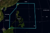
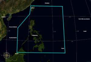
activity and issues warnings if they fall within the Philippine Area of Responsibility or PAR. This area is bound by an imaginary line drawn along the following coordinates:
- 25°N 120°E, 25°N 135°E, 5°N 135°E, 5°N 115°E, 15°N 115°E, 21°N 120°E and back to the beginning.
Warning system
A warning system is any system of biological or technical nature deployed by an individual or group to inform of a future danger. Its purpose is to enable the deployer of the warning system to prepare for the danger and act accordingly to mitigate or avoid it....
, days after several more powerful and destructive tornadoes damaged houses in Central Luzon
Central Luzon
Central Luzon , also known as Region III , is an administrative division or region of the Republic of the Philippines, primarily serve to organize the 7 provinces of the vast central plain of the island of Luzon , for administrative convenience...
, the monsoon
Monsoon
Monsoon is traditionally defined as a seasonal reversing wind accompanied by corresponding changes in precipitation, but is now used to describe seasonal changes in atmospheric circulation and precipitation associated with the asymmetric heating of land and sea...
and climate change
Climate change
Climate change is a significant and lasting change in the statistical distribution of weather patterns over periods ranging from decades to millions of years. It may be a change in average weather conditions or the distribution of events around that average...
. On August 23, 2007, a 2nd tornado destroyed 30 houses in 4 villages in San Miguel
San Miguel, Bulacan
San Miguel de Mayumo is a 1st class, partially urban municipality located in the 3rd district of the province of Bulacan, Philippines. According to the latest census, it has a population of 138,839 people.-History:...
, Bulacan
Bulacan
Bulacan , officially called the Province of Bulacan or simply Bulacan Province, is a first class province of the Republic of the Philippines located in the Central Luzon Region in the island of Luzon, north of Manila , and part of the Metro...
, the first having damaged 27 houses in San Rafael
San Rafael, Bulacan
San Rafael is a 1st class municipality in the province of Bulacan, Philippines. According to the latest census, it has a population of 85,284 inhabitants in 14,639 households.-Barangays:...
on Aug. 8.
Climatology
The climate of the Philippines is discussed in detail on the Climatology page of the PAGASA website.PAGASA lists patterns of Temperature, Humidity, Rainfall, Seasons, and four Climate Types, for the Philippines.
Climate Types are:
- Type 1 - Two pronounced seasons: Dry from November to April, Wet rest of the year.
- Type 2 - No dry season, but with heavier rainfall November to January.
- Type 3 - Seasons are not very pronounced, relatively dry from November to April, and wet during the rest of the year.
- Type 4 - Rainfall is more or less evenly distributed throughout the year.
Criticism of PAGASA
On August 6, 2010, President Benigno Aquino IIIBenigno Aquino III
Benigno Simeon Cojuangco Aquino III , also known as Noynoy Aquino or PNoy, is a Filipino politician who has been the 15th and current President of the Philippines since June 2010....
announced the removal of Prisco Nilo
Prisco Nilo
Prisco Duarte Nilo is a Filipino meteorologist. He is the former administrator of the Philippine Atmospheric, Geophysical and Astronomical Services Administration ....
as the administrator of PAGASA. PAGASA was directly under Department of Science and Technology
Department of Science and Technology (Philippines)
The Philippines' Department of Science and Technology , abbreviated as the DOST, is the executive department of the Philippine Government responsible for the coordination of science and technology-related projects in the Philippines and to formulate policies and projects in the fields of science...
(DOST) Undersecretary for Research and Development (R&D) Graciano Yumul. A special order from DOST Secretary Mario Montejo
Mario Montejo
Mario G. Montejo is the current Philippine Secretary of Science and Technology. On June 29, 2010, President Benigno Aquino III picked him as his Secretary of Science and Technology.-Science and Technology Secretary:...
, dated August 5, 2010, designated Yumul as the new PAGASA administrator. Nilo was criticized for lack of modern equipment, forecast inaccuracies, slow voluntary response and the aftermath of Typhoon Ondoy in 2009, and Typhoon Basyang
Typhoon Conson (2010)
Typhoon Conson was the second tropical cyclone during the 2010 Pacific typhoon season to impact the Philippines. Developing out of a tropical disturbance east of the Philippines on July 11, 2010, Conson quickly developed as it tracked nearly due west...
in July 2010.
Doppler radar and other equipment
PAGASA installed its first Doppler weather radar station in Baler, AuroraBaler, Aurora
Baler is a 4th class municipality in the province of Aurora, Philippines. It is the provincial capital of Aurora. According to the latest census, it has a population of 34,492 people and 5.955 members per household....
and another in Baguio this year, the new weather radar can monitor the typhoon and its movements, amount of rainfall either moderate or heavy and real-time atmospheric forecasts using a visual radar monitor,one example that the weather radar monitored Typhoon Basyang for the first time, this new technology can to be used for future weather warnings. It hopes to install five to seven radars in areas like Tagaytay (under construction), Aparri, Cagayan
Cagayan
Cagayan , the "Land of Smiling Beauty", is a province of the Philippines in the Cagayan Valley region in Luzon. Its capital is Tuguegarao City and is located at the northeastern corner of the island of Luzon. Cagayan also includes the Babuyan Islands to the north. The province borders Ilocos Norte...
, Subic
Subic
Subic can mean any of the following:*House of Šubić, a noble clan from Dalmatia.*Subic Bay, in the Philippines.*Subic, Zambales, a municipality in the Philippines.*Subic Bay Freeport Zone , an economic free trade area in the Philippines....
, Zambales
Zambales
Zambales is a province of the Philippines located in the Central Luzon region. Its capital is Iba. Zambales borders Pangasinan to the north, Tarlac and Pampanga to the east, and Bataan to the south. The province lies between the South China Sea and the Zambales Mountains. With a land area of...
, Virac
Virac, Catanduanes
Virac is a 1st class municipality in the province of Catanduanes, Philippines. It is the capital municipality of the province and the third largest town with a land area of 188 km2...
, Catanduanes
Catanduanes
Catanduanes is an island province of the Philippines located in the Bicol Region in Luzon. Its capital is Virac and the province lies to the east of Camarines Sur across Maqueda Channel. As of 2007, the population of the province is 232,757 people.-Etymology:"Isla de Cobos" was Catanduanes' first...
, Cebu City
Cebu City
The City of Cebu is the capital city of Cebu and is the second largest city in the Philippines, the second most significant metropolitan centre in the Philippines and known as the oldest settlement established by the Spaniards in the country.The city is located on the eastern shore of Cebu and was...
and Mandaue City
Mandaue City
The City of Mandaue is a city in the province of Cebu in the Philippines. It is one of the three urbanized cities in the island and forms a part of the Cebu Metropolitan area. Mandaue City is located on the middle eastern coastal region of Cebu, bordering to its right-side are Mactan Island where...
, Cebu
Cebu
Cebu is a province in the Philippines, consisting of Cebu Island and 167 surrounding islands. It is located to the east of Negros, to the west of Leyte and Bohol islands...
, and Guiuan, Eastern Samar
Eastern Samar
Eastern Samar is a province of the Philippines located in the Eastern Visayas region. Its capital is the city of Borongan.-Location:...
and three more in Mindanao
Mindanao
Mindanao is the second largest and easternmost island in the Philippines. It is also the name of one of the three island groups in the country, which consists of the island of Mindanao and smaller surrounding islands. The other two are Luzon and the Visayas. The island of Mindanao is called The...
by 2011. Before Nilo's leave, an automated rain gauge was also installed in a telecommunications cellsite in Montalban
Montalbán
Montalbán is a town and municipality in Spain with a population of 1,538, an area of 82 km² and a density of 18.75, located in Teruel province, in the autonomous community of Aragón. It is the historical and cultural capital of the Cuencas Mineras Aragonese comarca.The Sierra de San Just rises...
, Rizal
Rizal
Rizal is a province located in the CALABARZON , just 16 kilometers east of Manila. The province was named after the country's national hero, José Rizal. Rizal Governor Casimiro A. Ynares III on June 17, 2008 announced the transfer of the Capitol from Pasig. Its P 270-million capitol building,...
(in cooperation with Smart Communications
Smart Communications
Smart Communications is a wholly owned mobile phone and Internet service subsidiary of the Philippine Long Distance Telephone Company .On June 30, 2010 the company reported that it had over 45 million cellular subscribers.-Brands:...
) to monitor excess rainfall as a warning signal to avert the effects of flashflood
Flash flood
A flash flood is a rapid flooding of geomorphic low-lying areas—washes, rivers, dry lakes and basins. It may be caused by heavy rain associated with a storm, hurricane, or tropical storm or meltwater from ice or snow flowing over ice sheets or snowfields...
s and landslide
Landslide
A landslide or landslip is a geological phenomenon which includes a wide range of ground movement, such as rockfalls, deep failure of slopes and shallow debris flows, which can occur in offshore, coastal and onshore environments...
s by using cellphones, the weather bureau plans to adopt its swift transfer of data from ground forecasting stations to main headquarters utilizing its automated data acquisition system modeled after Japan Meteorological Agency
Japan Meteorological Agency
The or JMA, is the Japanese government's weather service. Charged with gathering and reporting weather data and forecasts in Japan, it is a semi-autonomous part of the Ministry of Land, Infrastructure and Transport...
's AMeDAS
AMeDAS
AMeDAS , commonly known in Japanese as "アメダス" , is a high-resolution surface observation network developed by Japan Meteorological Agency used for gathering regional weather data and verifying forecast performance...
in the near future as a solution to forecast inaccuracy and their problems. The Japan International Cooperation Agency
Japan International Cooperation Agency
The Japan International Cooperation Agency is an independent governmental agency that coordinates official development assistance for the government of Japan...
will provide modernization programs to enhance the services of PAGASA include meteorology and flood forecasting, and tornado warnings as precautionary measures. Seven new Doppler Radars placed in different locations are scheduled to operate in June 2011.
In addition, the weather bureau introduced its Landslide Early Warning Sensor (LEWS)
Emergency population warning
An emergency population warning is a method whereby local, regional, or national authorities can contact members of the public en masse to warn them of an impending emergency...
(recently invented by the University of the Philippines
University of the Philippines
The ' is the national university of the Philippines. Founded in 1908 through Act No...
) to reduce landslide casualties in case of landslide
Landslide
A landslide or landslip is a geological phenomenon which includes a wide range of ground movement, such as rockfalls, deep failure of slopes and shallow debris flows, which can occur in offshore, coastal and onshore environments...
s. Using this new device, the sensor picks out signals in the form of computer data to show soil and ground movements and is transferred to the ground station immediately in an event of a landslide, and in order to launch forced evacuation. PAGASA hopes to install 10 sensors in five landslide prone areas by 2012, when it is tested and ready to bury on ground.
Another innovation to flood alerts was the adoption of an Automated Weather Station (AWS) designed to monitor amounts of rainfall and flood levels in case of an incoming warning, the AWS can be controlled by a computer even it is unmanned and a siren to evacuate people for emergencies. Few of the AWS units are installed in few points of the country and many more units will be installed to extend its coverage.
See also
- Pacific typhoon season
- Amado PinedaAmado PinedaAmado Pineda is a Filipino meteorologist who became the first widely recognized television weatherman in the Philippines.A meteorologist with the Philippine Atmospheric, Geophysical and Astronomical Services Administration , Pineda began doing weather forecasts for the evening newscast of GMA...
- Climate of the PhilippinesClimate of the PhilippinesThe Climate of the Philippines is either tropical rainforest, tropical savanna or tropical monsoon, or humid subtropical characterized by relatively high temperature, oppressive humidity and plenty of rainfall. There are two seasons in the country, the wet season and the dry season, based upon...
- Doppler weather radar
- Prisco NiloPrisco NiloPrisco Duarte Nilo is a Filipino meteorologist. He is the former administrator of the Philippine Atmospheric, Geophysical and Astronomical Services Administration ....