

Scarborough Shoal
Encyclopedia
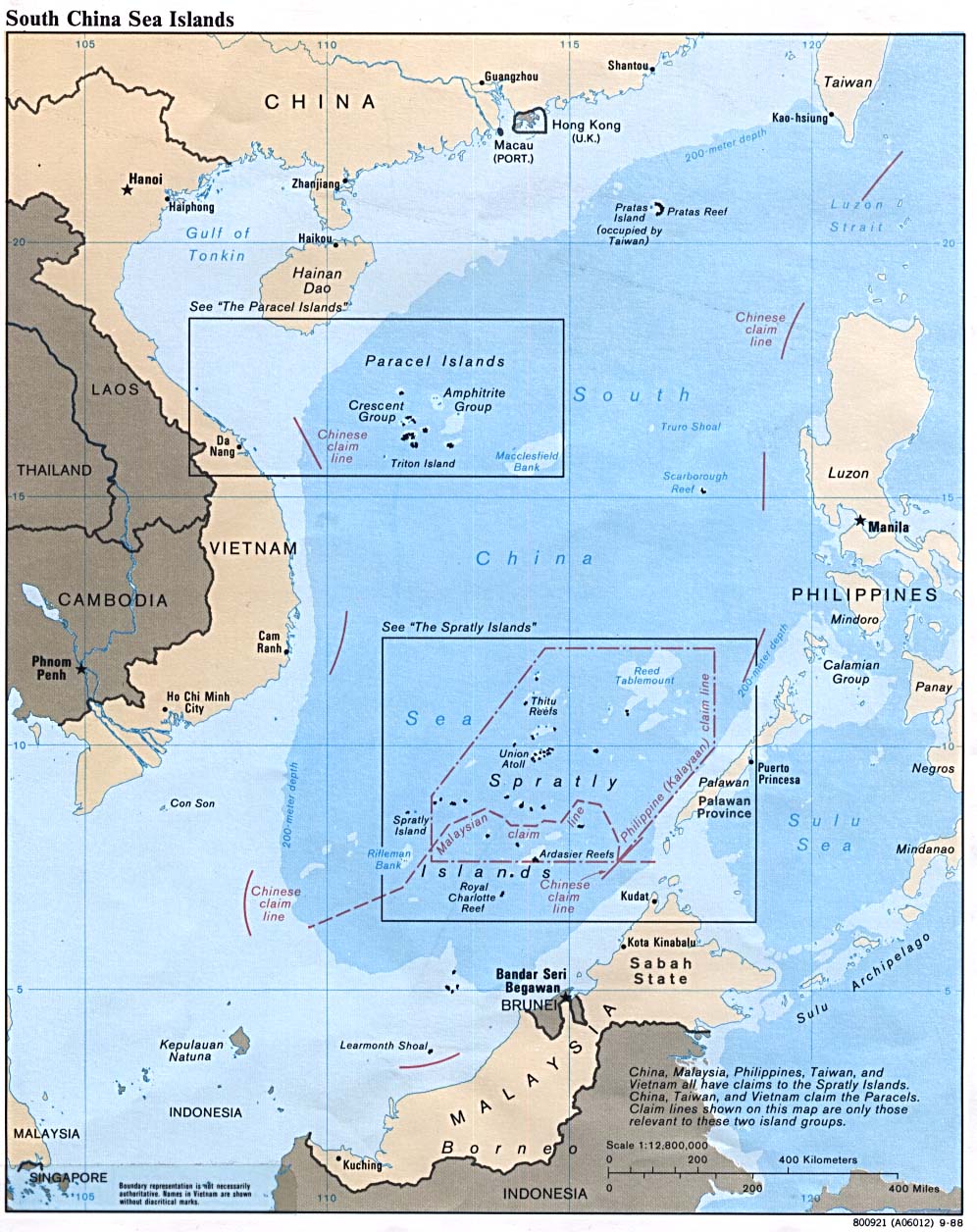
Scarborough Shoal or Scarborough Reef (Philippine name: Panatag Shoal; Chinese name: Huangyan Island; ), more correctly described as a group of islands and reef
s in an atoll
shape than a shoal
, is located between the Macclesfield Bank
and Luzon
, Philippines
in the South China Sea
. As with most of the landforms in this sea, the sovereignty
of the area is disputed. The Philippines
, the People's Republic of China
, and the Republic of China
(Taiwan
) all lay claim to the shoal. Most references exclude this atoll from inclusion in the Spratly Islands
, of which the closest is 350 km to the southwest.
The shoal was named after a tea-trade ship Scarborough which was wrecked on the rock with everyone perished on board in the late 18th century.
forms a triangle shaped chain of reefs and islands (but mostly rocks) 55 kilometres (34 mi) around with an of area 150 square kilometers. It has a lagoon
with area of 130 km² and depth of about 15 metres (49 ft). The shoal is a protrusion in a 3,500 m deep abyssal plain. Several of the islands including "South Rock" are 1/2 m to 3 m high and many of the reefs are just below water at high tide. Near the mouth of the lagoon are the ruins of an iron tower, 8.3 m high. The nearest landmass is Palauig
, Zambales
, on Luzon
Island in the Philippines
, 137 miles (220 km) away. It is about 123 miles (198 km) west of Subic Bay
.
colonization of the Philippines, Filipino fishermen were already using the area as a fishing ground and shelter during bad weather. In 1957, The Philippine government conducted an oceanographic survey of the area and together with the US Navy force based in then U.S. Naval Base Subic Bay
in Zambales, used the area as an impact range for defense purposes. An 8.3 meter high flag pole flying a Philippine flag was raised in 1965. A small lighthouse was also built and operated the same year. In 1992, the Philippine Navy rehabilitated the lighthouse and reported it to the International Maritime Organization
for publication in the List of Lights. As of 2009, the military-maintained lighthouse is non-operational. In 1997, The Philippines again, officially expressed its claim to Scarborough Shoal; a flag was again raised; and the Department of Environment and Natural Resources together with the University of the Philippines
conducted scientific, topographic and marine studies in the shoal.
The Philippines bases its claim on its proximity and the principle of terra nullius
, which holds that it was previously unclaimed by a sovereign state
, which is also applied by the Philippines
in its claims to the Spratly Islands. By virtue of the PD No.1599 issued by President Ferdinand Marcos
on June 1978, the Philippines claims an Exclusive Economic Zone (EEZ)
, up to 200 nautical miles (370.4 km) from the baselines from which their territorial sea is measured. In 2009, President Gloria Macapagal-Arroyo
enacted the Philippine Baselines Law of 2009 (RA 9522). The new law classifies the Spratly Islands
and the Scarborough Shoal as a regime of islands under the Republic of the Philippines.
and the Republic of China
(Taiwan) basis for claims are that the shoal was first mapped in the Yuan Dynasty
as early as 1279 and was historically used by Chinese fishermen. In 1279, Guo Shoujing
, a Chinese astronomer, performed surveying of the South China Sea
for Kublai Khan
, and the surveying point was reported to be the Scarborough Shoal. In 1935, China regarded the shoal as part of the Zhongsha Islands. In 1947, China published a map drawing a U-shaped line of claim across South China Sea
; the shoal lies within the claim administered from Hainan
province. China further asserted its claim shortly after the departure of the US Navy force from Subic, Zambales, Philippines. China states that the territorial claim by the Philippine government is new. Treaties on the territory of the Philippines and Philippine constitution in 1935 and maritime claims in 1961 state that the westernmost line of the Philippine territory is 118 East longitude, and the shoal is situated on the western side of the line. Furthermore, maps published before 1990 did not include the shoal as the territory of the Philippines.
Reef
In nautical terminology, a reef is a rock, sandbar, or other feature lying beneath the surface of the water ....
s in an atoll
Atoll
An atoll is a coral island that encircles a lagoon partially or completely.- Usage :The word atoll comes from the Dhivehi word atholhu OED...
shape than a shoal
Shoal
Shoal, shoals or shoaling may mean:* Shoal, a sandbank or reef creating shallow water, especially where it forms a hazard to shipping* Shoal draught , of a boat with shallow draught which can pass over some shoals: see Draft...
, is located between the Macclesfield Bank
Macclesfield Bank
Macclesfield Bank or Zhongsha Islands is an elongated sunken atoll of underwater reefs and shoals in the South China Sea and part of the disputed South China Sea Islands, centred around , east of the Paracel Islands. Its length exceeds southwest-northeast, with a maximal width of more than...
and Luzon
Luzon
Luzon is the largest island in the Philippines. It is located in the northernmost region of the archipelago, and is also the name for one of the three primary island groups in the country centered on the Island of Luzon...
, Philippines
Philippines
The Philippines , officially known as the Republic of the Philippines , is a country in Southeast Asia in the western Pacific Ocean. To its north across the Luzon Strait lies Taiwan. West across the South China Sea sits Vietnam...
in the South China Sea
South China Sea
The South China Sea is a marginal sea that is part of the Pacific Ocean, encompassing an area from the Singapore and Malacca Straits to the Strait of Taiwan of around...
. As with most of the landforms in this sea, the sovereignty
Sovereignty
Sovereignty is the quality of having supreme, independent authority over a geographic area, such as a territory. It can be found in a power to rule and make law that rests on a political fact for which no purely legal explanation can be provided...
of the area is disputed. The Philippines
Philippines
The Philippines , officially known as the Republic of the Philippines , is a country in Southeast Asia in the western Pacific Ocean. To its north across the Luzon Strait lies Taiwan. West across the South China Sea sits Vietnam...
, the People's Republic of China
People's Republic of China
China , officially the People's Republic of China , is the most populous country in the world, with over 1.3 billion citizens. Located in East Asia, the country covers approximately 9.6 million square kilometres...
, and the Republic of China
Republic of China
The Republic of China , commonly known as Taiwan , is a unitary sovereign state located in East Asia. Originally based in mainland China, the Republic of China currently governs the island of Taiwan , which forms over 99% of its current territory, as well as Penghu, Kinmen, Matsu and other minor...
(Taiwan
Taiwan
Taiwan , also known, especially in the past, as Formosa , is the largest island of the same-named island group of East Asia in the western Pacific Ocean and located off the southeastern coast of mainland China. The island forms over 99% of the current territory of the Republic of China following...
) all lay claim to the shoal. Most references exclude this atoll from inclusion in the Spratly Islands
Spratly Islands
The Spratly Islands are a group of more than 750 reefs, islets, atolls, cays and islands in the South China Sea. The archipelago lies off the coasts of the Philippines and Malaysia , about one third of the way from there to southern Vietnam. They comprise less than four square kilometers of land...
, of which the closest is 350 km to the southwest.
The shoal was named after a tea-trade ship Scarborough which was wrecked on the rock with everyone perished on board in the late 18th century.
Geography
The shoalShoal
Shoal, shoals or shoaling may mean:* Shoal, a sandbank or reef creating shallow water, especially where it forms a hazard to shipping* Shoal draught , of a boat with shallow draught which can pass over some shoals: see Draft...
forms a triangle shaped chain of reefs and islands (but mostly rocks) 55 kilometres (34 mi) around with an of area 150 square kilometers. It has a lagoon
Lagoon
A lagoon is a body of shallow sea water or brackish water separated from the sea by some form of barrier. The EU's habitat directive defines lagoons as "expanses of shallow coastal salt water, of varying salinity or water volume, wholly or partially separated from the sea by sand banks or shingle,...
with area of 130 km² and depth of about 15 metres (49 ft). The shoal is a protrusion in a 3,500 m deep abyssal plain. Several of the islands including "South Rock" are 1/2 m to 3 m high and many of the reefs are just below water at high tide. Near the mouth of the lagoon are the ruins of an iron tower, 8.3 m high. The nearest landmass is Palauig
Palauig, Zambales
Palauig is a 3rd class municipality in the province of Zambales, Philippines. According to the latest census, it has a population of 30,747 people in 5,945 households....
, Zambales
Zambales
Zambales is a province of the Philippines located in the Central Luzon region. Its capital is Iba. Zambales borders Pangasinan to the north, Tarlac and Pampanga to the east, and Bataan to the south. The province lies between the South China Sea and the Zambales Mountains. With a land area of...
, on Luzon
Luzon
Luzon is the largest island in the Philippines. It is located in the northernmost region of the archipelago, and is also the name for one of the three primary island groups in the country centered on the Island of Luzon...
Island in the Philippines
Philippines
The Philippines , officially known as the Republic of the Philippines , is a country in Southeast Asia in the western Pacific Ocean. To its north across the Luzon Strait lies Taiwan. West across the South China Sea sits Vietnam...
, 137 miles (220 km) away. It is about 123 miles (198 km) west of Subic Bay
Subic Bay
Subic Bay is a bay forming part of Luzon Sea on the west coast of the island of Luzon in Zambales, Philippines, about 100 kilometers northwest of Manila Bay. Its shores were formerly the site of a major United States Navy facility named U.S...
.
Activities in the surrounding area
The shoal and its surrounding area are rich fishing grounds. A significant number of Chinese fishermen have already been arrested by Philippine officials in this area, particularly during 1998-2001, most of them were charged with illegal methods of fishing and catching endangered and protected species that destroy the area's marine habitat and ecological sustainability. Thick layers of guano lie on the rocks in the area. Several Filipino-sponsored and Chinese-sponsored diving excursions and amateur ham radio operations, DXpeditions (1994, 1995, 1997 and 2007), were carried out in the area.The Philippines
The Philippines claims that as early as the SpanishSpanish people
The Spanish are citizens of the Kingdom of Spain. Within Spain, there are also a number of vigorous nationalisms and regionalisms, reflecting the country's complex history....
colonization of the Philippines, Filipino fishermen were already using the area as a fishing ground and shelter during bad weather. In 1957, The Philippine government conducted an oceanographic survey of the area and together with the US Navy force based in then U.S. Naval Base Subic Bay
U.S. Naval Base Subic Bay
U.S. Naval Base Subic Bay was a major ship-repair, supply, and rest and recreation facility of the United States Navy located in Zambales, Philippines. It was the largest U.S...
in Zambales, used the area as an impact range for defense purposes. An 8.3 meter high flag pole flying a Philippine flag was raised in 1965. A small lighthouse was also built and operated the same year. In 1992, the Philippine Navy rehabilitated the lighthouse and reported it to the International Maritime Organization
International Maritime Organization
The International Maritime Organization , formerly known as the Inter-Governmental Maritime Consultative Organization , was established in Geneva in 1948, and came into force ten years later, meeting for the first time in 1959...
for publication in the List of Lights. As of 2009, the military-maintained lighthouse is non-operational. In 1997, The Philippines again, officially expressed its claim to Scarborough Shoal; a flag was again raised; and the Department of Environment and Natural Resources together with the University of the Philippines
University of the Philippines
The ' is the national university of the Philippines. Founded in 1908 through Act No...
conducted scientific, topographic and marine studies in the shoal.
The Philippines bases its claim on its proximity and the principle of terra nullius
Terra nullius
Terra nullius is a Latin expression deriving from Roman law meaning "land belonging to no one" , which is used in international law to describe territory which has never been subject to the sovereignty of any state, or over which any prior sovereign has expressly or implicitly relinquished...
, which holds that it was previously unclaimed by a sovereign state
Sovereign state
A sovereign state, or simply, state, is a state with a defined territory on which it exercises internal and external sovereignty, a permanent population, a government, and the capacity to enter into relations with other sovereign states. It is also normally understood to be a state which is neither...
, which is also applied by the Philippines
Philippines
The Philippines , officially known as the Republic of the Philippines , is a country in Southeast Asia in the western Pacific Ocean. To its north across the Luzon Strait lies Taiwan. West across the South China Sea sits Vietnam...
in its claims to the Spratly Islands. By virtue of the PD No.1599 issued by President Ferdinand Marcos
Ferdinand Marcos
Ferdinand Emmanuel Edralin Marcos, Sr. was a Filipino leader and an authoritarian President of the Philippines from 1965 to 1986. He was a lawyer, member of the Philippine House of Representatives and a member of the Philippine Senate...
on June 1978, the Philippines claims an Exclusive Economic Zone (EEZ)
Exclusive Economic Zone
Under the law of the sea, an exclusive economic zone is a seazone over which a state has special rights over the exploration and use of marine resources, including production of energy from water and wind. It stretches from the seaward edge of the state's territorial sea out to 200 nautical...
, up to 200 nautical miles (370.4 km) from the baselines from which their territorial sea is measured. In 2009, President Gloria Macapagal-Arroyo
Gloria Macapagal-Arroyo
Gloria Macapagal-Arroyo is a Filipino politician who served as the 14th President of the Philippines from 2001 to 2010, as the 12th Vice President of the Philippines from 1998 to 2001, and is currently a member of the House of Representatives representing the 2nd District of Pampanga...
enacted the Philippine Baselines Law of 2009 (RA 9522). The new law classifies the Spratly Islands
Spratly Islands
The Spratly Islands are a group of more than 750 reefs, islets, atolls, cays and islands in the South China Sea. The archipelago lies off the coasts of the Philippines and Malaysia , about one third of the way from there to southern Vietnam. They comprise less than four square kilometers of land...
and the Scarborough Shoal as a regime of islands under the Republic of the Philippines.
The People's Republic of China and Republic of China
The People's Republic of ChinaPeople's Republic of China
China , officially the People's Republic of China , is the most populous country in the world, with over 1.3 billion citizens. Located in East Asia, the country covers approximately 9.6 million square kilometres...
and the Republic of China
Republic of China
The Republic of China , commonly known as Taiwan , is a unitary sovereign state located in East Asia. Originally based in mainland China, the Republic of China currently governs the island of Taiwan , which forms over 99% of its current territory, as well as Penghu, Kinmen, Matsu and other minor...
(Taiwan) basis for claims are that the shoal was first mapped in the Yuan Dynasty
Yuan Dynasty
The Yuan Dynasty , or Great Yuan Empire was a ruling dynasty founded by the Mongol leader Kublai Khan, who ruled most of present-day China, all of modern Mongolia and its surrounding areas, lasting officially from 1271 to 1368. It is considered both as a division of the Mongol Empire and as an...
as early as 1279 and was historically used by Chinese fishermen. In 1279, Guo Shoujing
Guo Shoujing
Guo Shoujing , courtesy name Ruosi , was a Chinese astronomer, engineer, and mathematician born in Xingtai, Hebei who lived during the Yuan Dynasty...
, a Chinese astronomer, performed surveying of the South China Sea
South China Sea
The South China Sea is a marginal sea that is part of the Pacific Ocean, encompassing an area from the Singapore and Malacca Straits to the Strait of Taiwan of around...
for Kublai Khan
Kublai Khan
Kublai Khan , born Kublai and also known by the temple name Shizu , was the fifth Great Khan of the Mongol Empire from 1260 to 1294 and the founder of the Yuan Dynasty in China...
, and the surveying point was reported to be the Scarborough Shoal. In 1935, China regarded the shoal as part of the Zhongsha Islands. In 1947, China published a map drawing a U-shaped line of claim across South China Sea
South China Sea
The South China Sea is a marginal sea that is part of the Pacific Ocean, encompassing an area from the Singapore and Malacca Straits to the Strait of Taiwan of around...
; the shoal lies within the claim administered from Hainan
Hainan
Hainan is the smallest province of the People's Republic of China . Although the province comprises some two hundred islands scattered among three archipelagos off the southern coast, of its land mass is Hainan Island , from which the province takes its name...
province. China further asserted its claim shortly after the departure of the US Navy force from Subic, Zambales, Philippines. China states that the territorial claim by the Philippine government is new. Treaties on the territory of the Philippines and Philippine constitution in 1935 and maritime claims in 1961 state that the westernmost line of the Philippine territory is 118 East longitude, and the shoal is situated on the western side of the line. Furthermore, maps published before 1990 did not include the shoal as the territory of the Philippines.