
Paracel Islands
Encyclopedia
The Paracel Islands, also called Xisha Islands (西沙群岛) in Chinese and Hoàng Sa Islands in Vietnamese, is a group of islands under the administration of Hainan Province, The People's Republic of China. Vietnam
and the Republic of China
(Taiwan
) also claim sovereignty of these islands. The People's Republic of China and South Vietnam
each controlled part of the Paracel Islands before 1974. A brief conflict in 1974 resulted in 71 soldiers being killed, and China has controlled the whole of Paracel since then, though this control is still disputed by Vietnam.
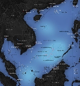
The Paracel Islands consist of over 30 islets, sandbanks or reefs, occupy about 15,000 km² of the ocean surface, and are located in the South China Sea
. Turtle
s live on the islands, and seabirds have left nests and guano
deposits, but there are no permanent human residents except for a small number of troops. The archipelago
is approximately equidistant from the coastlines of Vietnam and China, 180 nautical miles SE of Hainan Island, and about one-third of the way from central Vietnam
to the northern Philippines
.
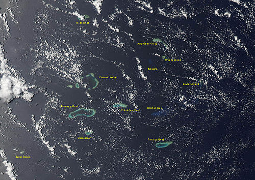
The islands are divided into two main groups. The Amphitrite group is in the northeast and the Crescent group is in the southwest, and they are located about 70 km (43 mi) from one another. Subject to hot and humid climate, with abundant rainfall and frequent typhoons, the archipelago is surrounded by productive fishing grounds and potential oil and gas reserves.
Amphitrite of the Jesuit missionary
.
Lying in the most northeastern of the Paracel Islands, at the coordinates of 16.97 degrees North and 112.28 degrees East, the group consists of six low narrow islands with sand cay
s; enclose shallow lagoon
s, connected by reef
s of rock, and about 37 km (23 mi) northwest from Lincoln Island. The northern section of the group comprises South Island, Middle Island, North Island, and Tree Island. The last unit lies toward the eastern tip of this section with coconut
palm trees seen on the island. Together they form the upper branch of an ellipse
of 22 km (14 mi) long semimajor axis that approximately orientates from west to east. The southern section consists of two islands called Woody and Rocky Islands lying very near each other. The former located approximately 5 km (3 mi) southwards from the southern tip of the east extremity of the northern section. This feature is the largest island of the Amphitrite group.
|-
| colspan="2" |
The Paracel Islands, also called Xisha Islands (西沙群岛) in Chinese and Hoàng Sa Islands in Vietnamese, is a group of islands under the administration of Hainan Province, The People's Republic of China. Vietnam
and the Republic of China
(Taiwan
) also claim sovereignty of these islands. The People's Republic of China and South Vietnam
each controlled part of the Paracel Islands before 1974. A brief conflict in 1974 resulted in 71 soldiers being killed, and China has controlled the whole of Paracel since then, though this control is still disputed by Vietnam.
The Paracel Islands consist of over 30 islets, sandbanks or reefs, occupy about 15,000 km² of the ocean surface, and are located in the South China Sea
. Turtle
s live on the islands, and seabirds have left nests and guano
deposits, but there are no permanent human residents except for a small number of troops. The archipelago
is approximately equidistant from the coastlines of Vietnam and China, 180 nautical miles SE of Hainan Island, and about one-third of the way from central Vietnam
to the northern Philippines
.
The islands are divided into two main groups. The Amphitrite group is in the northeast and the Crescent group is in the southwest, and they are located about 70 km (43 mi) from one another. Subject to hot and humid climate, with abundant rainfall and frequent typhoons, the archipelago is surrounded by productive fishing grounds and potential oil and gas reserves.
Amphitrite of the Jesuit missionary
.
Lying in the most northeastern of the Paracel Islands, at the coordinates of 16.97 degrees North and 112.28 degrees East, the group consists of six low narrow islands with sand cay
s; enclose shallow lagoon
s, connected by reef
s of rock, and about 37 km (23 mi) northwest from Lincoln Island. The northern section of the group comprises South Island, Middle Island, North Island, and Tree Island. The last unit lies toward the eastern tip of this section with coconut
palm trees seen on the island. Together they form the upper branch of an ellipse
of 22 km (14 mi) long semimajor axis that approximately orientates from west to east. The southern section consists of two islands called Woody and Rocky Islands lying very near each other. The former located approximately 5 km (3 mi) southwards from the southern tip of the east extremity of the northern section. This feature is the largest island of the Amphitrite group.
|-
| colspan="2" |

Crescent Group, looking westward
|}
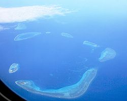
Lying about 70 km (43 mi) southwest of Amphitrite group, at the latitude of 16.52 degrees North and the longitude of 111.63 degrees East, this group consists of 8 islands and forms a crescent-like structure hanging from west to east and enclosing a deep central lagoon
. The group measures 31 km (19 mi) and 15 km (9 mi) in length and width, from east to west and from north to south, respectively. All of the islands of the group are vegetated except for small cay
s. Located in the southwestern extremity of the group, at the hanging point of the crescent structure, is Money Island
. This feature has some small cays in the southern side. The Antelope Reef, submerged at high tide and containing a central lagoon, lies 2.4 km (1.5 mi) east of the island of Money. Respectively, northeast of this reef are Robert and Pattle Islands. They are separated from each other by a 3.5 km (2.2 mi) wide, deep channel. The latter is the largest island of the group; a lighthouse
and a radio and weather station were built there on 1937. The Observation Bank situates at the northernmost of the Crescent group and contains a small cay; from the southeastern side lying a 12 km (7 mi) long, boomerang
shaped reef with the island of Drummond. The last distinct unit of the atoll
-like structure is the Duncan Islands group, which is approximately 3 km (2 mi) west of the Drummond Island and about 8 km (5 mi) east of the island of Antelope.
|+List of Paracel Islands (See map below for locations)
|-
!English name!!Chinese name!!Vietnamese name!!coordinates!!Area(km2)||Location/Note
|-
|Amphitrite Group||Xuande Islands (宣德群岛)||Nhóm An Vĩnh||16°50′N 112°20′E||-||NE of the Islands
|-
|Woody Island||Yongxing Dao (永兴岛)||Đảo Phú Lâm||16°50′N 112°19′E||2.1||Has airport, Center East
|-
|Rocky Island||Shidao
(石岛)||Đảo Hòn Đá||16°50′N 112°19′E||0.08||connected to (NE of) Woody, 14m elev.
|-
|West Sand||Xisha Zhou (西沙洲)||Cồn Cát Tây||16°50′N 112°19′E||0.04||NW of Amphitrite Group
|-
|Tree Island||Zhaoshudao (赵述岛)||Đảo Cây||16°50′N 112°19′E||0.22||North of Amphitrite Group
|-
|(seven sisters)||Qilian Yu Subgroup(七连屿)||-||-||-||NE of Amphitrite Group
|-
|North Island||Bei Dao (北岛)||Đảo Bắc||16°50′N 112°19′E||0.04||N of Seven Islets(1)
|-
|Middle Island||Zhong Dao (中岛)||Đảo Trung/Giữa||16°50′N 112°19′E||0.13||N2 of Seven Islets(2)
|-
|South Island||Nan Dao (南岛)||Đảo Nam||16°50′N 112°19′E||0.17||N3 of Seven Islets(4)
|-
|(North Sand)||Bei Sha Zhou (北沙洲)||Cồn Cát Bắc||16°50′N 112°19′E||0.02||N4 of Seven Islets(4)
|-
|Middle Sand||Zhong Sha Zhou (中沙洲)||Đá Trung||16°50′N 112°19′E||0.05||N5 of Seven Islets(5)
|-
|South Sand||Nan Sha Zhou (南沙洲)||Cồn Cát Nam||16°50′N 112°19′E||0.06||N6 of Seven Islets(6)
|-
|(New West Sand)||Xixinsha Zhou (西新沙洲)||Chuỗi Tiên Sa||16°50′N 112°19′E||0.002||N7a of Seven Islets(7W)
|-
|(south of South Sand)||Dong Xin Sha Zhou (东新沙洲)||Chuỗi Cát Bằng||16°50′N 112°19′E||0.004||N7b of Seven Islets(7E)
|-
|Itis Bank||Yin Shuo Tan (银铄滩)||Bãi Liên Đông||16°50′N 112°19′E||-||SW of Amphitrite Group
|-
|Crescent Group||Yongle Islands(永樂群島)||Nhóm Trăng Khuyết; Lưỡi Liềm||16°30′N 111°40′E||-||-
|-
|Money Island||Jinyin Dao (金银岛)||Đảo Quang Ảnh||16°30′N 111°40′E||0.36|||West end of Crescent Group
|-
|Robert Island||Ganquan Dao (甘泉岛)||Đảo Hữu Nhật||16°30′N 111°40′E||0.30|||W side of Crescent Group
|-
|Pattle Island||Shanhu Dao (珊瑚岛)||Đảo Hoàng Sa||16°30′N 111°40′E||0.31|||N of Robert Island
|-
|Antelope Reef||Lingyang Jiao (羚羊礁)||Bãi ngầm Sơn Dương||16°30′N 111°40′E||-|||W side of Crescent Group, S of Robert Is.
|-
|(Little Basket Sandbank)||Kuangzai Shazhou (筐仔沙洲)||Bãi Đá Nổi||16°30′N 111°40′E||0.01|||S of Crescent Group
|-
|Duncan Island||Shenhang Dao (琛航岛)||Đảo Quang Hòa Đông
Đảo Quang Hòa Tây||16°30′N 111°40′E||0.28|||S side of Crescent Group
|-
|(Guangjin Island)||Guangjin Dao (广金岛)||Đảo Hoàng Châu||16°30′N 111°40′E||0.06|||S side of Crescent Group
|-
|Drummond Island||Jinqing Dao (晋卿岛)||Đảo Duy Mộng||16°30′N 111°40′E||0.21|||SE of Crescent Group
|-
|(Stone Islet)||Shi Yu (石屿)||Hòn Đá Nổi||16°30′N 111°40′E||0.002|||NE of Crescent Group
|-
|(Minor Silver Islet)||Yinyu Zai (银屿仔)||Hòn Vọng Tuyết||16°30′N 111°40′E||0.002|||SE of Yin Yu
|-
|(Silver Islet)||Yin Yu (银屿)||Hòn Đá Bạc||16°30′N 111°40′E||0.01|||NE of Crescent Group
|-
|(He Duck Island)||Yagong Dao (鸭公岛)||Đảo Khe Sang||16°30′N 111°40′E||0.01|||SW of Yin Yu
|-
|(All Wealth Island)||Quanfu Dao (全富岛)||Đảo Phú Hảo||16°30′N 111°40′E||0.02|||NE of Pattle,SW of Yin Yu
|-
|(Salty Hut Islet)||Xianshe Yu (咸舍屿)||Hòn Đá Mặn||16°30′N 111°40′E||-|||W of Shiyu
|-
|Other features||-||-||-||-||-
|-
|Triton Island ||Zhongjiandao (中建岛)||Đảo Tri Tôn||15°40′N 111°10′E||1.20|||SW of the Islands
|-
|Discovery Reef ||Huaguang Jiao (华光礁)|| Đá Lồi||16°10′N 111°40′E||-|||S of Xuande Islands (宣德群岛)
|-
|Passu Keah ||Panshi Yu (盘石屿)||Đảo Bạch Quy (Rùa Trắng)||16°05′N 111°35′E||0.40|||S of Discovery Reef
|-
|(Songtao Beach) ||Songtao Tan (嵩焘滩)||Đảo Ngân Quý||15°35′N 112°15′E||-|||Central South of the Islands
|-
|Bombay Reef ||Langhuajiao
(浪花礁)||Đá Bông Bay||16°02′N 112°32′E||-|||SE of the Islands
|-
|Vuladdore Reef ||Yuduo Jiao (玉琢礁)||Đảo Chim Yến||16°20′N 112°00′E||-|||SE of Xuande Islands, Center of the Islands
|-
|Bremen Bank ||Binmei Tan (滨湄滩)||Bãi ngầm Bremen||16°22′N 112°40′E||-|||Eastern Group
|-
|Jehangire Bank ||Zhanhan Tan (湛涵滩)||Bãi ngầm Jehangire||16°20′N 112°30′E||-|||Eastern Group
|-
|Neptune Bank ||Beibian Lang (北边廊)||Bãi Thổ Tinh||16°31′N 112°31′E||-|||Eastern Group
|-
|Pyramid Rock ||Gaojian Shi (高尖石)||Hòn Tháp||16°35′N 112°08′E||0.04|||Eastern Group
|-
|Lincoln Island ||Dong Dao (东岛)||Đảo Linh Côn||16°40′N 112°18′E||1.60|||Eastern Group
|-
|Dido Bank ||Xidu Tan (西渡滩)||Rặng Thuỷ Tứ||16°48′N 112°52′E||-|||SE of the Islands
|-
|North Reef||Beijiao (北礁)||Cồn Bắc||17°05′N 111°30′E||-|||NW of the Islands
|}
Note that the English names are direct translation for the Chinese name (or vice versa), for most of the Islands, with the exception of a few islands named after English person names such as Woody/Yongxing, Tree/Zhaoshu, Itis/Yinshuo, Robert/Jinquan, Pattle/Shandu, Duncan/Shenhang, Drummond/Jinqing.
e.g. Dao-Island, Bei=North, Money Gold Silver = Jinyin
. The Chinese called the different groups of islands in the South China Sea
Western Beach (Xisha, Paracel), Southern Beach (Nansha
, Spratly), Eastern Beach (Dongsha, Pratas) and Central Beach respectively. In a Chinese book published in Ming Dynasty
Voyage with the Tail Wind (:zh:順風相送), the islands were called Wanglishitang (万里石塘) or "Ten Thousands Miles of Stone Pond" (“舟过此〔七洲洋〕极险,稍贪东便是万里石塘”). The same name is also presented in the Map of Zheng He
's Voyage (郑和航海图).
were treated as the features of Hoàng Sa. Only under the reign of Emperor Minh Mạng
(1820–1841) when the Spratlys were distinctly delineated and officially named Vạn Lý Trường Sa, the Ten-thousand-league Long Sandbank. It is believed that much of the Vietnamese documentation relating to the islands was lost during the three major wars, including a thousand years of constant struggles and battles against the Chinese domination, a hundred years of waves of uprisings to regain independence from France, and more than two decades of bloody fighting in the Vietnam war
. This war-torn nation has witnessed many significant changes during its history, including the country name, but the name of the islands, Hoàng Sa, has not changed in more than five hundred years.
As early as at the beginning of the 16th century, had the Portuguese vessels frequented the South China Sea; then later came the Dutch
, the English, the Spanish, and the French. They all wanted to become a major trader in the region of great opportunities commercially, but was still less known to the west. The name Paracel started replacing Pracel on maps and charts as the century passed. Typically, on the "Map of the coast of Tonquin and Cochinchina", made in 1747 by Pierre d'Hondt, the dangerous band of rugged rocks was labeled "Le Paracel", a French phonetic notation. Because of its peculiarity on an important water channel, Ilhas de Pracel (Pracel Islands) had drawn much attention from navigators and hydrographers for several centuries. In addition, recent disputes have once again inflamed the popularity of the islands; but the origination of the terminology is still vaguely understood. There are different stories about the names but none of them are able to provide any convincing evidence.
The report "Paracel and Spratly Islands on Charts and Maps made by Westerners" by Dr. Dai-Viet Nguyen (Nguyễn Đại Việt) of Vietnamese Nationalist Party (Việt Nam Quốc Dân Đảng) has shed light on the origin of the terminology. Part of his findings included various citations, typically:
The coast of Brazil from Santa Catharina island to Maranluio presents a peculiarity which is worthy of remark; for it appears as though it were encircled by two bands of elevated ground (dentures de haut fonds), which, except in a few intervals, are continued throughout all its extent, and seem as if intended to defend the land from the encroachment and impetuosity of the waves, which continually lash the shores. One of these defences adjacent to the land is a ridge rocks, which forms a kind of border, extending principally from cape Frio to Maranhao. The other natural bulwark or defence of the coast is a bank, situated from 2 to 10 leagues from the land, generally of a moderate though irregular depth, which the natives term Pracel or Paracel, as all the depths are unequal and irregular where the inhabitants fish. It may be said that this Pracel the same as the recife...
or,
Off Mount Melançia (Ion. 39 degrees 18') before noticed a bank commences which thence extends all the way to the River Iguarassu, an extent of 45 leagues. This bank which is called in the country Pracel de Caracu from the name of the most considerable hamlet on this part of the coast, extends outward about 3 leagues from the shore, and is circumscribed by the depth of 6 fathoms...
Ecologically, it is understood that the terminology was used to classify a certain islands, rather than being used as a proper noun. Notably, that class of islands seems to possess a number of special characteristics, which may be defined as follows:
Pracel is a moderately elevated chain of islets, sandbanks, and reefs. These features are continuously distributed and stretched over a noticeable distance of tens or hundreds of kilometers in length. Pracel may not be a suitable place for human residents, but its irregular depth creates an ideal environment inhabited by fish. Pracel often forms a natural bulwark as an outer line of defense for a coast or a land.
Regarding the features off the coast of the Kingdom of Cauchi China, their structure closely fits the above description. By piecing all the elements together, undoubtedly, it is the Portuguese people who purposely classified them as a pracel in their native language in the early 16th century. Pracel is an antiquated variation of the now much more common form parcel, which was used by the Portuguese navigators
to designate shallow seas or sea banks, and is still widely found in the toponimy of Portuguese-speaking countries.
Approximately three hundred and fifty years later, in the early-mid-19th century, Ilhas de Pracel was divided into two archipelagos. From that time onwards, the names Paracel Islands and Spratly Islands
have become more popular internationally and widely used on charts, maps, and related documents.
. The People Republic of China's postal zip code of the island is 572000, and the telephone area code is +86 (0898).
. The runway is of 2400m long, and can handle landing and take-off of Boeing-737 or planes of similar size. Flight services operate on Haikou
- Xisha route. There are three main roads on Woody Island. There is also a 800m long cement bank connecting Woody Island and Rocky Island.
The territorial dispute and its historical background
The sovereignty
of the archipelago has been the subject of disputes among People's Republic of China
, Republic of China
(Taiwan
), and Vietnam
since the 20th century. Around the mid-19th century, after conquering Vietnam, France subsequently took over and administered the islands on behalf of her colony
. In 1883 German boats surveyed the islands but withdrew the survey eventually after receiving protests from the Qing Dynasty
of China.
France annexed the islands as part of French Indochina
despite protests from China in the 1930s, but was taken over by Japanese troops during the Second Sino-Japanese War
. Japan renounced the claims to the islands after the war and the Republic of China
retook the Paracel islands in late 1946. A small Chinese platoon was stationed on Woody Island
.
After the success of communists in the Chinese Civil War
in 1949, the People's Republic of China
took control of Woody Island
, the main island of the Amphitrite group and the only island that was occupied at the time. Pattle Island, the largest of the Crescent group, on the other hand, was later taken by the French Indochina
and then controlled by South Vietnam
following independence in 1956. Tensions over the islands continued to rise unceasingly since then.
In 1974, the political and diplomatic dispute on the islands became an armed conflict between the People's Republic of China
and South Vietnam
. On 16 January, South Vietnamese army officers and an American observer reported to Saigon some suspected military activities of the People's Liberation Army Navy
at the Drummond and Duncan islands. After receiving the report, the government of South Vietnam
(Republic of Vietnam) decided to counter the PRC forces, and sent a unit of frigates to the area. On 19 January, there were sea and land battles between the Chinese and Vietnamese forces with casualties on both sides. At the end, the PLAN
fleet defeated the naval force of South Vietnam. With the ongoing civil war embroiling South Vietnam's attention and the absence of the USA's backing, no military attempt was made to re-engage the PRC over the islands. After the military engagement and the subsequent victory, the PRC gained the entire archipelago and has taken control of Paracel Islands ever since. It was a significant turning point for the PRC but the sovereignty dispute on the islands remains unresolved with Vietnam
.
and Song
dynasty eras,Hainan was a part of Guangdong by then. and there is some evidence of Chinese habitation on the islands in these periods. According to the Wujing Zongyao
, a book published in the Northern Song dynasty in 1044, the Song government then included the Islands in the patrol areas of the Navy of the Court.
emperor sent the famous high-level official and astronomer, Guo Shoujing
, to the South China Sea to survey and measure the islands and the surrounding sea area. Guo's base of survey was located in the Paracel Islands. His activities were well recorded in Yuan Shi, or History of Yuan
. According to Yuan Shi, the South China Sea islands were within the boundary of the Yuan Dynasty. Maps published in the Yuan era invariably included the Changsha (the Paracels) and the Shitang (the Spratlys) within the domain of Yuan.
(1368~1644) and the Qing
(1644~1912) dynasties continued to . The Qiongzhou
Prefecture (the highest administrative authority in Hainan
) exercised jurisdiction over the Paracel and Spratly Islands in the Ming and Qing Dynasties. In 1883, the Qing government lodged strong protests against Germany when the Germans were conducting survey activities in the Paracel and Spratly areas; as a result of such protests, the Germans had to terminate their survey activities. The Sino-French treaty of 1887 between Qing China and France, who had occupied Indochina
by that time, expressly provided that the islands east of a delimitation line, known as the Sino-Tonkin delimitation line, should belong to China, whereas the Paracel and Spratly Islands are located east of the delimitation line. In 1910, the Qing government decided to invite Chinese merchants to contract for the administration of the development affairs of the South China Sea islands, and demanded that officials shall provide protection and maintenance in order to highlight Chinese territory and protect its titles and interests.
Province decided to place the Paracel Islands under the jurisdiction of the Ya Xian County of Hainan
Prefecture in 1911. The Southern Military Government in 1921 reaffirmed the 1911 decision. The Republic of China continued to exercise authority over the South China Sea islands by such means as granting licenses or contracts to private Chinese merchants for the development and exploitation of guano and other resources on those islands and protesting against foreign nations' claims, occupations, and other activities.
On July 27, 1932, the Chinese Foreign Ministry instructed the Chinese Envoy to France to lodge a diplomatic protest to the French Foreign Ministry and to deny France's claims to the Paracel Islands. On November 30 of the same year, Zhu Zhaoshen, a high-level inspection official of the Chinese Foreign Ministry, issued public correspondence Number 66 to the French Consul in Guangzhou
, reiterating that "it is absolutely beyond doubt that the Xisha [Paracel] Islands fall within the boundary of China". Despite repeated Chinese protests, French troops, who had colonized Indochina
in the 19th century, invaded and occupied the Paracel Islands on July 3, 1938. This took place shortly after the breakout of the Second Sino-Japanese War
, when China was fully engaged in resisting Japan's invasion. Three days later, on July 6, the Japanese Foreign Ministry also issued a declaration in protest of the French occupation:
During the Second World War, Japanese expelled the French troops and took over the islands in spite of the 1938 declaration. At the end of the war (Asian-Pacific Region), the Government of the Republic of China formally retook the Paracels, Spratlys and other islands in the South China Sea in October and November 1946. In Geneva accord
of 1954 Japan formally renounced all of its claims to, inter alia, the South China Sea islands which it had occupied during the World War II.
20th century Events
Paracel in media
See also
External links
Vietnam
Vietnam – sometimes spelled Viet Nam , officially the Socialist Republic of Vietnam – is the easternmost country on the Indochina Peninsula in Southeast Asia. It is bordered by China to the north, Laos to the northwest, Cambodia to the southwest, and the South China Sea –...
and the Republic of China
Republic of China
The Republic of China , commonly known as Taiwan , is a unitary sovereign state located in East Asia. Originally based in mainland China, the Republic of China currently governs the island of Taiwan , which forms over 99% of its current territory, as well as Penghu, Kinmen, Matsu and other minor...
(Taiwan
Taiwan
Taiwan , also known, especially in the past, as Formosa , is the largest island of the same-named island group of East Asia in the western Pacific Ocean and located off the southeastern coast of mainland China. The island forms over 99% of the current territory of the Republic of China following...
) also claim sovereignty of these islands. The People's Republic of China and South Vietnam
South Vietnam
South Vietnam was a state which governed southern Vietnam until 1975. It received international recognition in 1950 as the "State of Vietnam" and later as the "Republic of Vietnam" . Its capital was Saigon...
each controlled part of the Paracel Islands before 1974. A brief conflict in 1974 resulted in 71 soldiers being killed, and China has controlled the whole of Paracel since then, though this control is still disputed by Vietnam.
The Paracel Islands consist of over 30 islets, sandbanks or reefs, occupy about 15,000 km² of the ocean surface, and are located in the South China Sea
South China Sea
The South China Sea is a marginal sea that is part of the Pacific Ocean, encompassing an area from the Singapore and Malacca Straits to the Strait of Taiwan of around...
. Turtle
Turtle
Turtles are reptiles of the order Testudines , characterised by a special bony or cartilaginous shell developed from their ribs that acts as a shield...
s live on the islands, and seabirds have left nests and guano
Guano
Guano is the excrement of seabirds, cave dwelling bats, and seals. Guano manure is an effective fertilizer due to its high levels of phosphorus and nitrogen and also its lack of odor. It was an important source of nitrates for gunpowder...
deposits, but there are no permanent human residents except for a small number of troops. The archipelago
Archipelago
An archipelago , sometimes called an island group, is a chain or cluster of islands. The word archipelago is derived from the Greek ἄρχι- – arkhi- and πέλαγος – pélagos through the Italian arcipelago...
is approximately equidistant from the coastlines of Vietnam and China, 180 nautical miles SE of Hainan Island, and about one-third of the way from central Vietnam
Central Vietnam
Central Vietnam or Central , formerly also known as Trung phần by Republic of Vietnam, Trung kỳ and Annam under French Indochina) is one of the three regions of Vietnam . Highlands or Tây Nguyên are often included in the Central...
to the northern Philippines
Philippines
The Philippines , officially known as the Republic of the Philippines , is a country in Southeast Asia in the western Pacific Ocean. To its north across the Luzon Strait lies Taiwan. West across the South China Sea sits Vietnam...
.
The islands are divided into two main groups. The Amphitrite group is in the northeast and the Crescent group is in the southwest, and they are located about 70 km (43 mi) from one another. Subject to hot and humid climate, with abundant rainfall and frequent typhoons, the archipelago is surrounded by productive fishing grounds and potential oil and gas reserves.
Geography
Geographic data
- Geographic coordinates: 16°30′N 112°00′E
- Coastline: 518 km
- Climate: tropical
- Elevation extremes:
- lowest point: South China Sea 0 m
- highest point: unnamed location on Rocky Island 14 m
- Natural resources: fishery, coral reef, possible oil and gas nearby
- Natural hazards: typhoons
Amphitrite Group
The Amphitrite group was named after the French frigateFrigate
A frigate is any of several types of warship, the term having been used for ships of various sizes and roles over the last few centuries.In the 17th century, the term was used for any warship built for speed and maneuverability, the description often used being "frigate-built"...
Amphitrite of the Jesuit missionary
Missionary
A missionary is a member of a religious group sent into an area to do evangelism or ministries of service, such as education, literacy, social justice, health care and economic development. The word "mission" originates from 1598 when the Jesuits sent members abroad, derived from the Latin...
.
Lying in the most northeastern of the Paracel Islands, at the coordinates of 16.97 degrees North and 112.28 degrees East, the group consists of six low narrow islands with sand cay
Cay
A cay , also spelled caye or key, is a small, low-elevation, sandy island formed on the surface of coral reefs. Cays occur in tropical environments throughout the Pacific, Atlantic and Indian Oceans , where they provide habitable and agricultural land for hundreds of thousands of people...
s; enclose shallow lagoon
Lagoon
A lagoon is a body of shallow sea water or brackish water separated from the sea by some form of barrier. The EU's habitat directive defines lagoons as "expanses of shallow coastal salt water, of varying salinity or water volume, wholly or partially separated from the sea by sand banks or shingle,...
s, connected by reef
Reef
In nautical terminology, a reef is a rock, sandbar, or other feature lying beneath the surface of the water ....
s of rock, and about 37 km (23 mi) northwest from Lincoln Island. The northern section of the group comprises South Island, Middle Island, North Island, and Tree Island. The last unit lies toward the eastern tip of this section with coconut
Coconut
The coconut palm, Cocos nucifera, is a member of the family Arecaceae . It is the only accepted species in the genus Cocos. The term coconut can refer to the entire coconut palm, the seed, or the fruit, which is not a botanical nut. The spelling cocoanut is an old-fashioned form of the word...
palm trees seen on the island. Together they form the upper branch of an ellipse
Ellipse
In geometry, an ellipse is a plane curve that results from the intersection of a cone by a plane in a way that produces a closed curve. Circles are special cases of ellipses, obtained when the cutting plane is orthogonal to the cone's axis...
of 22 km (14 mi) long semimajor axis that approximately orientates from west to east. The southern section consists of two islands called Woody and Rocky Islands lying very near each other. The former located approximately 5 km (3 mi) southwards from the southern tip of the east extremity of the northern section. This feature is the largest island of the Amphitrite group.
- West SandWest SandWest Sand is an island located in the Amphitrite Group of the Paracel Islands in the South China Sea. It is administrated by the People's Republic of China. Sovereignty over the island is disputed by Vietnam. It is approximately west of Tree Island....
- Tree IslandTree Island, South China SeaFor the "Tree Island" in Tuen Mun District, New Territories, Hong Kong, see Pak Chau.Tree Island or Zhaoshu Island is one of the main islands of Paracel Islands in South China Sea. The Chinese named the island as Zhaoshu Dao to commemorate Zhao Shu who accompanied Zheng He's expeditions in high...
- Woody IslandWoody Island, South China SeaWoody Island, also known as Yongxing Island , is one of the major islands of Paracel Islands in South China Sea. It is administrated by the People's Republic of China through the Yongxingdao Neighborhood Committee. It has no indigenous inhabitants, although there are People's Liberation Army...
- Rocky Island
Crescent Group
{| class="infobox geography vcard" style="width:23em;"|-
| colspan="2" |
The Paracel Islands, also called Xisha Islands (西沙群岛) in Chinese and Hoàng Sa Islands in Vietnamese, is a group of islands under the administration of Hainan Province, The People's Republic of China. Vietnam
Vietnam
Vietnam – sometimes spelled Viet Nam , officially the Socialist Republic of Vietnam – is the easternmost country on the Indochina Peninsula in Southeast Asia. It is bordered by China to the north, Laos to the northwest, Cambodia to the southwest, and the South China Sea –...
and the Republic of China
Republic of China
The Republic of China , commonly known as Taiwan , is a unitary sovereign state located in East Asia. Originally based in mainland China, the Republic of China currently governs the island of Taiwan , which forms over 99% of its current territory, as well as Penghu, Kinmen, Matsu and other minor...
(Taiwan
Taiwan
Taiwan , also known, especially in the past, as Formosa , is the largest island of the same-named island group of East Asia in the western Pacific Ocean and located off the southeastern coast of mainland China. The island forms over 99% of the current territory of the Republic of China following...
) also claim sovereignty of these islands. The People's Republic of China and South Vietnam
South Vietnam
South Vietnam was a state which governed southern Vietnam until 1975. It received international recognition in 1950 as the "State of Vietnam" and later as the "Republic of Vietnam" . Its capital was Saigon...
each controlled part of the Paracel Islands before 1974. A brief conflict in 1974 resulted in 71 soldiers being killed, and China has controlled the whole of Paracel since then, though this control is still disputed by Vietnam.
The Paracel Islands consist of over 30 islets, sandbanks or reefs, occupy about 15,000 km² of the ocean surface, and are located in the South China Sea
South China Sea
The South China Sea is a marginal sea that is part of the Pacific Ocean, encompassing an area from the Singapore and Malacca Straits to the Strait of Taiwan of around...
. Turtle
Turtle
Turtles are reptiles of the order Testudines , characterised by a special bony or cartilaginous shell developed from their ribs that acts as a shield...
s live on the islands, and seabirds have left nests and guano
Guano
Guano is the excrement of seabirds, cave dwelling bats, and seals. Guano manure is an effective fertilizer due to its high levels of phosphorus and nitrogen and also its lack of odor. It was an important source of nitrates for gunpowder...
deposits, but there are no permanent human residents except for a small number of troops. The archipelago
Archipelago
An archipelago , sometimes called an island group, is a chain or cluster of islands. The word archipelago is derived from the Greek ἄρχι- – arkhi- and πέλαγος – pélagos through the Italian arcipelago...
is approximately equidistant from the coastlines of Vietnam and China, 180 nautical miles SE of Hainan Island, and about one-third of the way from central Vietnam
Central Vietnam
Central Vietnam or Central , formerly also known as Trung phần by Republic of Vietnam, Trung kỳ and Annam under French Indochina) is one of the three regions of Vietnam . Highlands or Tây Nguyên are often included in the Central...
to the northern Philippines
Philippines
The Philippines , officially known as the Republic of the Philippines , is a country in Southeast Asia in the western Pacific Ocean. To its north across the Luzon Strait lies Taiwan. West across the South China Sea sits Vietnam...
.
The islands are divided into two main groups. The Amphitrite group is in the northeast and the Crescent group is in the southwest, and they are located about 70 km (43 mi) from one another. Subject to hot and humid climate, with abundant rainfall and frequent typhoons, the archipelago is surrounded by productive fishing grounds and potential oil and gas reserves.
Geography
Geographic data
- Geographic coordinates: 16°30′N 112°00′E
- Coastline: 518 km
- Climate: tropical
- Elevation extremes:
- lowest point: South China Sea 0 m
- highest point: unnamed location on Rocky Island 14 m
- Natural resources: fishery, coral reef, possible oil and gas nearby
- Natural hazards: typhoons
Amphitrite Group
The Amphitrite group was named after the French frigateFrigate
A frigate is any of several types of warship, the term having been used for ships of various sizes and roles over the last few centuries.In the 17th century, the term was used for any warship built for speed and maneuverability, the description often used being "frigate-built"...
Amphitrite of the Jesuit missionary
Missionary
A missionary is a member of a religious group sent into an area to do evangelism or ministries of service, such as education, literacy, social justice, health care and economic development. The word "mission" originates from 1598 when the Jesuits sent members abroad, derived from the Latin...
.
Lying in the most northeastern of the Paracel Islands, at the coordinates of 16.97 degrees North and 112.28 degrees East, the group consists of six low narrow islands with sand cay
Cay
A cay , also spelled caye or key, is a small, low-elevation, sandy island formed on the surface of coral reefs. Cays occur in tropical environments throughout the Pacific, Atlantic and Indian Oceans , where they provide habitable and agricultural land for hundreds of thousands of people...
s; enclose shallow lagoon
Lagoon
A lagoon is a body of shallow sea water or brackish water separated from the sea by some form of barrier. The EU's habitat directive defines lagoons as "expanses of shallow coastal salt water, of varying salinity or water volume, wholly or partially separated from the sea by sand banks or shingle,...
s, connected by reef
Reef
In nautical terminology, a reef is a rock, sandbar, or other feature lying beneath the surface of the water ....
s of rock, and about 37 km (23 mi) northwest from Lincoln Island. The northern section of the group comprises South Island, Middle Island, North Island, and Tree Island. The last unit lies toward the eastern tip of this section with coconut
Coconut
The coconut palm, Cocos nucifera, is a member of the family Arecaceae . It is the only accepted species in the genus Cocos. The term coconut can refer to the entire coconut palm, the seed, or the fruit, which is not a botanical nut. The spelling cocoanut is an old-fashioned form of the word...
palm trees seen on the island. Together they form the upper branch of an ellipse
Ellipse
In geometry, an ellipse is a plane curve that results from the intersection of a cone by a plane in a way that produces a closed curve. Circles are special cases of ellipses, obtained when the cutting plane is orthogonal to the cone's axis...
of 22 km (14 mi) long semimajor axis that approximately orientates from west to east. The southern section consists of two islands called Woody and Rocky Islands lying very near each other. The former located approximately 5 km (3 mi) southwards from the southern tip of the east extremity of the northern section. This feature is the largest island of the Amphitrite group.
- West SandWest SandWest Sand is an island located in the Amphitrite Group of the Paracel Islands in the South China Sea. It is administrated by the People's Republic of China. Sovereignty over the island is disputed by Vietnam. It is approximately west of Tree Island....
- Tree IslandTree Island, South China SeaFor the "Tree Island" in Tuen Mun District, New Territories, Hong Kong, see Pak Chau.Tree Island or Zhaoshu Island is one of the main islands of Paracel Islands in South China Sea. The Chinese named the island as Zhaoshu Dao to commemorate Zhao Shu who accompanied Zheng He's expeditions in high...
- Woody IslandWoody Island, South China SeaWoody Island, also known as Yongxing Island , is one of the major islands of Paracel Islands in South China Sea. It is administrated by the People's Republic of China through the Yongxingdao Neighborhood Committee. It has no indigenous inhabitants, although there are People's Liberation Army...
- Rocky Island
Crescent Group
{| class="infobox geography vcard" style="width:23em;"|-
| colspan="2" |
Duncan Islands
Drummond Island
Money Island
Antelope Reef
Robert Island
Pattle Island
Observation Bank
|}
Lying about 70 km (43 mi) southwest of Amphitrite group, at the latitude of 16.52 degrees North and the longitude of 111.63 degrees East, this group consists of 8 islands and forms a crescent-like structure hanging from west to east and enclosing a deep central lagoon
Lagoon
A lagoon is a body of shallow sea water or brackish water separated from the sea by some form of barrier. The EU's habitat directive defines lagoons as "expanses of shallow coastal salt water, of varying salinity or water volume, wholly or partially separated from the sea by sand banks or shingle,...
. The group measures 31 km (19 mi) and 15 km (9 mi) in length and width, from east to west and from north to south, respectively. All of the islands of the group are vegetated except for small cay
Cay
A cay , also spelled caye or key, is a small, low-elevation, sandy island formed on the surface of coral reefs. Cays occur in tropical environments throughout the Pacific, Atlantic and Indian Oceans , where they provide habitable and agricultural land for hundreds of thousands of people...
s. Located in the southwestern extremity of the group, at the hanging point of the crescent structure, is Money Island
Money Island, Paracel Islands
Money Island or Jinyin Island, is the southwesternmost island in the Crescent Group of the Paracel Islands archipelago. It rises to a height of 6 metres and is covered with brush. At the eastern side of the island lies an extensive reef, which contains a central lagoon, but the reef is mostly...
. This feature has some small cays in the southern side. The Antelope Reef, submerged at high tide and containing a central lagoon, lies 2.4 km (1.5 mi) east of the island of Money. Respectively, northeast of this reef are Robert and Pattle Islands. They are separated from each other by a 3.5 km (2.2 mi) wide, deep channel. The latter is the largest island of the group; a lighthouse
Lighthouse
A lighthouse is a tower, building, or other type of structure designed to emit light from a system of lamps and lenses or, in older times, from a fire, and used as an aid to navigation for maritime pilots at sea or on inland waterways....
and a radio and weather station were built there on 1937. The Observation Bank situates at the northernmost of the Crescent group and contains a small cay; from the southeastern side lying a 12 km (7 mi) long, boomerang
Boomerang
A boomerang is a flying tool with a curved shape used as a weapon or for sport.-Description:A boomerang is usually thought of as a wooden device, although historically boomerang-like devices have also been made from bones. Modern boomerangs used for sport are often made from carbon fibre-reinforced...
shaped reef with the island of Drummond. The last distinct unit of the atoll
Atoll
An atoll is a coral island that encircles a lagoon partially or completely.- Usage :The word atoll comes from the Dhivehi word atholhu OED...
-like structure is the Duncan Islands group, which is approximately 3 km (2 mi) west of the Drummond Island and about 8 km (5 mi) east of the island of Antelope.
- Pattle Islands
- Money IslandMoney Island, Paracel IslandsMoney Island or Jinyin Island, is the southwesternmost island in the Crescent Group of the Paracel Islands archipelago. It rises to a height of 6 metres and is covered with brush. At the eastern side of the island lies an extensive reef, which contains a central lagoon, but the reef is mostly...
- Drummond Island
- Duncan Islands
Other features
- Bombay Reef: The elongated-structure reefReefIn nautical terminology, a reef is a rock, sandbar, or other feature lying beneath the surface of the water ....
situates at the southeastern corner of the Paracel Islands and lies approximately 90 km (56 mi) southeast from the Crescent Group. With most parts are submerged, the reef is measured approximately 18 km (11 mi) and 5 km (3 mi) from east to west and from north to south, respectively. The Bombay Reef encloses a deep lagoonLagoonA lagoon is a body of shallow sea water or brackish water separated from the sea by some form of barrier. The EU's habitat directive defines lagoons as "expanses of shallow coastal salt water, of varying salinity or water volume, wholly or partially separated from the sea by sand banks or shingle,...
with rocks on its edge. - Bremen Bank: Located 24 km (15 mi) north from Bombay Reef, the submerged shallow bank is measured approximately 23 km (14 mi) in length from northeast to southwest. The shallowest area is about 12 m and located in the southwestern part of the bank.
- Discovery Reef: Measured approximately 27 km (17 mi) in length from east to west, and 7 km (4 mi) from north to south, the reef is located about 18 km (11 mi) south from the Crescent Group. Completely submerged, the elongated ring structure is the largest single reef of the Paracel Islands. The reef has two large, deep openings into the lagoon on the southern side.
- Itis Bank: Located 11 km (7 mi) south from the Amphitrite Group, this shallow bank is measured approximately 5 km (3 mi) in length with an average depth of 12 m (39 ft).
- Lincoln Island: Surrounded by a coralCoralCorals are marine animals in class Anthozoa of phylum Cnidaria typically living in compact colonies of many identical individual "polyps". The group includes the important reef builders that inhabit tropical oceans and secrete calcium carbonate to form a hard skeleton.A coral "head" is a colony of...
reef, located 37 km (23 mi) southeast from the Amphitrite Group, the island is covered with brushes and fairly high trees, including coconutCoconutThe coconut palm, Cocos nucifera, is a member of the family Arecaceae . It is the only accepted species in the genus Cocos. The term coconut can refer to the entire coconut palm, the seed, or the fruit, which is not a botanical nut. The spelling cocoanut is an old-fashioned form of the word...
palm trees. The depth increases sharply on the northern and eastern sides of the island but the southern and south western regions are shallow. An observation post on the western side was found by officers of the German government surveys in 1883. In 1948, Great Britain requested France for permission to use the feature for military exercises. - North Reef: Situated approximately 56 km (35 mi) north from the Crescent group and about 70 km (43 mi) west-northwest from the Amphitrite group, the reef is the most northwesterly feature of the Paracel Islands. Most part of the reef is submerged. Ruggedly, rocks are around the edge and barely above water. There is a passage into the lagoon on the southwestern side of the reef.
- Passu Keah: This small reef encloses a shallow lagoon and located about 12 km (7 mi) south of eastern side of Discovery Reef, approximate 37 miles east-northeast from Triton Island. The sand cayCayA cay , also spelled caye or key, is a small, low-elevation, sandy island formed on the surface of coral reefs. Cays occur in tropical environments throughout the Pacific, Atlantic and Indian Oceans , where they provide habitable and agricultural land for hundreds of thousands of people...
measures 9 km (6 mi) in length. - Triton Island: The vegetated sand cay stands on a steep-sided coral reef and measures 1.5 km (0.93205910497471 mi) in length. This southernmost island of the Paracel Islands lies far away from the rest and situates about 56 km (35 mi) southwest of Discovery Reef.
- Vuladdore Reef: Mostly submerged, the reef orientates from east to west, measures 12 km (7 mi) and approximate 3 km (2 mi) in length and width, respectively. Lying near the center of the Paracel Islands, this feature situates about 18 km (11 mi) west-northwest from Discovery Reef. Some small spiral rocks are seen on the reef.
List of all Islands with Chinese and Vietnamese names
{|class="wikitable"|+List of Paracel Islands (See map below for locations)
|-
!English name!!Chinese name!!Vietnamese name!!coordinates!!Area(km2)||Location/Note
|-
|Amphitrite Group||Xuande Islands (宣德群岛)||Nhóm An Vĩnh||16°50′N 112°20′E||-||NE of the Islands
|-
|Woody Island||Yongxing Dao (永兴岛)||Đảo Phú Lâm||16°50′N 112°19′E||2.1||Has airport, Center East
|-
|Rocky Island||Shidao
Shidao
Rocky Island is one of the islands of Paracel Islands in South China Sea. It is under the administration of the People's Republic of China, and guarded by the PLA Navy. Vietnam also claims sovereignty of this island....
(石岛)||Đảo Hòn Đá||16°50′N 112°19′E||0.08||connected to (NE of) Woody, 14m elev.
|-
|West Sand||Xisha Zhou (西沙洲)||Cồn Cát Tây||16°50′N 112°19′E||0.04||NW of Amphitrite Group
|-
|Tree Island||Zhaoshudao (赵述岛)||Đảo Cây||16°50′N 112°19′E||0.22||North of Amphitrite Group
|-
|(seven sisters)||Qilian Yu Subgroup(七连屿)||-||-||-||NE of Amphitrite Group
|-
|North Island||Bei Dao (北岛)||Đảo Bắc||16°50′N 112°19′E||0.04||N of Seven Islets(1)
|-
|Middle Island||Zhong Dao (中岛)||Đảo Trung/Giữa||16°50′N 112°19′E||0.13||N2 of Seven Islets(2)
|-
|South Island||Nan Dao (南岛)||Đảo Nam||16°50′N 112°19′E||0.17||N3 of Seven Islets(4)
|-
|(North Sand)||Bei Sha Zhou (北沙洲)||Cồn Cát Bắc||16°50′N 112°19′E||0.02||N4 of Seven Islets(4)
|-
|Middle Sand||Zhong Sha Zhou (中沙洲)||Đá Trung||16°50′N 112°19′E||0.05||N5 of Seven Islets(5)
|-
|South Sand||Nan Sha Zhou (南沙洲)||Cồn Cát Nam||16°50′N 112°19′E||0.06||N6 of Seven Islets(6)
|-
|(New West Sand)||Xixinsha Zhou (西新沙洲)||Chuỗi Tiên Sa||16°50′N 112°19′E||0.002||N7a of Seven Islets(7W)
|-
|(south of South Sand)||Dong Xin Sha Zhou (东新沙洲)||Chuỗi Cát Bằng||16°50′N 112°19′E||0.004||N7b of Seven Islets(7E)
|-
|Itis Bank||Yin Shuo Tan (银铄滩)||Bãi Liên Đông||16°50′N 112°19′E||-||SW of Amphitrite Group
|-
|Crescent Group||Yongle Islands(永樂群島)||Nhóm Trăng Khuyết; Lưỡi Liềm||16°30′N 111°40′E||-||-
|-
|Money Island||Jinyin Dao (金银岛)||Đảo Quang Ảnh||16°30′N 111°40′E||0.36|||West end of Crescent Group
|-
|Robert Island||Ganquan Dao (甘泉岛)||Đảo Hữu Nhật||16°30′N 111°40′E||0.30|||W side of Crescent Group
|-
|Pattle Island||Shanhu Dao (珊瑚岛)||Đảo Hoàng Sa||16°30′N 111°40′E||0.31|||N of Robert Island
|-
|Antelope Reef||Lingyang Jiao (羚羊礁)||Bãi ngầm Sơn Dương||16°30′N 111°40′E||-|||W side of Crescent Group, S of Robert Is.
|-
|(Little Basket Sandbank)||Kuangzai Shazhou (筐仔沙洲)||Bãi Đá Nổi||16°30′N 111°40′E||0.01|||S of Crescent Group
|-
|Duncan Island||Shenhang Dao (琛航岛)||Đảo Quang Hòa Đông
Đảo Quang Hòa Tây||16°30′N 111°40′E||0.28|||S side of Crescent Group
|-
|(Guangjin Island)||Guangjin Dao (广金岛)||Đảo Hoàng Châu||16°30′N 111°40′E||0.06|||S side of Crescent Group
|-
|Drummond Island||Jinqing Dao (晋卿岛)||Đảo Duy Mộng||16°30′N 111°40′E||0.21|||SE of Crescent Group
|-
|(Stone Islet)||Shi Yu (石屿)||Hòn Đá Nổi||16°30′N 111°40′E||0.002|||NE of Crescent Group
|-
|(Minor Silver Islet)||Yinyu Zai (银屿仔)||Hòn Vọng Tuyết||16°30′N 111°40′E||0.002|||SE of Yin Yu
|-
|(Silver Islet)||Yin Yu (银屿)||Hòn Đá Bạc||16°30′N 111°40′E||0.01|||NE of Crescent Group
|-
|(He Duck Island)||Yagong Dao (鸭公岛)||Đảo Khe Sang||16°30′N 111°40′E||0.01|||SW of Yin Yu
|-
|(All Wealth Island)||Quanfu Dao (全富岛)||Đảo Phú Hảo||16°30′N 111°40′E||0.02|||NE of Pattle,SW of Yin Yu
|-
|(Salty Hut Islet)||Xianshe Yu (咸舍屿)||Hòn Đá Mặn||16°30′N 111°40′E||-|||W of Shiyu
|-
|Other features||-||-||-||-||-
|-
|Triton Island ||Zhongjiandao (中建岛)||Đảo Tri Tôn||15°40′N 111°10′E||1.20|||SW of the Islands
|-
|Discovery Reef ||Huaguang Jiao (华光礁)|| Đá Lồi||16°10′N 111°40′E||-|||S of Xuande Islands (宣德群岛)
|-
|Passu Keah ||Panshi Yu (盘石屿)||Đảo Bạch Quy (Rùa Trắng)||16°05′N 111°35′E||0.40|||S of Discovery Reef
|-
|(Songtao Beach) ||Songtao Tan (嵩焘滩)||Đảo Ngân Quý||15°35′N 112°15′E||-|||Central South of the Islands
|-
|Bombay Reef ||Langhuajiao
Langhuajiao
Langhuajiao is one of the islands of Paracel Islands. It is alternatively known as "Pengbojiao" , also known as "Qilianyu" along with six other islands close by. A Chinese-built lighthouse is located here. The island is administrated by the People's Republic of China and patrolled by the Chinese...
(浪花礁)||Đá Bông Bay||16°02′N 112°32′E||-|||SE of the Islands
|-
|Vuladdore Reef ||Yuduo Jiao (玉琢礁)||Đảo Chim Yến||16°20′N 112°00′E||-|||SE of Xuande Islands, Center of the Islands
|-
|Bremen Bank ||Binmei Tan (滨湄滩)||Bãi ngầm Bremen||16°22′N 112°40′E||-|||Eastern Group
|-
|Jehangire Bank ||Zhanhan Tan (湛涵滩)||Bãi ngầm Jehangire||16°20′N 112°30′E||-|||Eastern Group
|-
|Neptune Bank ||Beibian Lang (北边廊)||Bãi Thổ Tinh||16°31′N 112°31′E||-|||Eastern Group
|-
|Pyramid Rock ||Gaojian Shi (高尖石)||Hòn Tháp||16°35′N 112°08′E||0.04|||Eastern Group
|-
|Lincoln Island ||Dong Dao (东岛)||Đảo Linh Côn||16°40′N 112°18′E||1.60|||Eastern Group
|-
|Dido Bank ||Xidu Tan (西渡滩)||Rặng Thuỷ Tứ||16°48′N 112°52′E||-|||SE of the Islands
|-
|North Reef||Beijiao (北礁)||Cồn Bắc||17°05′N 111°30′E||-|||NW of the Islands
|}
Note that the English names are direct translation for the Chinese name (or vice versa), for most of the Islands, with the exception of a few islands named after English person names such as Woody/Yongxing, Tree/Zhaoshu, Itis/Yinshuo, Robert/Jinquan, Pattle/Shandu, Duncan/Shenhang, Drummond/Jinqing.
e.g. Dao-Island, Bei=North, Money Gold Silver = Jinyin
Xisha
The Chinese name Xisha (西沙), literally means Western Beach, refers to its location in the west of the South China SeaSouth China Sea
The South China Sea is a marginal sea that is part of the Pacific Ocean, encompassing an area from the Singapore and Malacca Straits to the Strait of Taiwan of around...
. The Chinese called the different groups of islands in the South China Sea
South China Sea
The South China Sea is a marginal sea that is part of the Pacific Ocean, encompassing an area from the Singapore and Malacca Straits to the Strait of Taiwan of around...
Western Beach (Xisha, Paracel), Southern Beach (Nansha
Nansha
Nansha may refer to:* Nansha Islands , the Chinese name of the Spratly Islands* Nansha District , a part of Guangzhou City* Nansha, Yunnan, a town in Yunnan Province...
, Spratly), Eastern Beach (Dongsha, Pratas) and Central Beach respectively. In a Chinese book published in Ming Dynasty
Ming Dynasty
The Ming Dynasty, also Empire of the Great Ming, was the ruling dynasty of China from 1368 to 1644, following the collapse of the Mongol-led Yuan Dynasty. The Ming, "one of the greatest eras of orderly government and social stability in human history", was the last dynasty in China ruled by ethnic...
Voyage with the Tail Wind (:zh:順風相送), the islands were called Wanglishitang (万里石塘) or "Ten Thousands Miles of Stone Pond" (“舟过此〔七洲洋〕极险,稍贪东便是万里石塘”). The same name is also presented in the Map of Zheng He
Zheng He
Zheng He , also known as Ma Sanbao and Hajji Mahmud Shamsuddin was a Hui-Chinese mariner, explorer, diplomat and fleet admiral, who commanded voyages to Southeast Asia, South Asia, the Middle East, and East Africa, collectively referred to as the Voyages of Zheng He or Voyages of Cheng Ho from...
's Voyage (郑和航海图).
Hoàng Sa
The Vietnamese call the islands Hoang Sa, (黃沙 or Yellow Sands), has been found in historic Vietnamese documents dating back to the 15th century. In the modern language system it is written as Hoàng Sa or Cát Vàng. They all have the same meaning that is the Yellow Sands or the Yellow Sandbank. Before the early 19th century, the present-day Spratly IslandsSpratly Islands
The Spratly Islands are a group of more than 750 reefs, islets, atolls, cays and islands in the South China Sea. The archipelago lies off the coasts of the Philippines and Malaysia , about one third of the way from there to southern Vietnam. They comprise less than four square kilometers of land...
were treated as the features of Hoàng Sa. Only under the reign of Emperor Minh Mạng
Minh Mang
Minh Mạng was the second emperor of the Nguyễn Dynasty of Vietnam, reigning from 14 February 1820 until 20 January 1841. He was a younger son of Emperor Gia Long, whose eldest son, Crown Prince Canh, had died in 1801...
(1820–1841) when the Spratlys were distinctly delineated and officially named Vạn Lý Trường Sa, the Ten-thousand-league Long Sandbank. It is believed that much of the Vietnamese documentation relating to the islands was lost during the three major wars, including a thousand years of constant struggles and battles against the Chinese domination, a hundred years of waves of uprisings to regain independence from France, and more than two decades of bloody fighting in the Vietnam war
Vietnam War
The Vietnam War was a Cold War-era military conflict that occurred in Vietnam, Laos, and Cambodia from 1 November 1955 to the fall of Saigon on 30 April 1975. This war followed the First Indochina War and was fought between North Vietnam, supported by its communist allies, and the government of...
. This war-torn nation has witnessed many significant changes during its history, including the country name, but the name of the islands, Hoàng Sa, has not changed in more than five hundred years.
Pracel and Paracel
On the "Map of Europe, Africa and Asia" published in 1598 by Cornelis Claez, an unnamed band of rocks and sandbanks shown in the neighborhood of the present-day location of the Paracel and Spratly Islands. About two decades later, the names Pracel and Costa de Pracel (Coast of Pracel) appeared on the "Chart of Asia and eight city maps" published in 1617 by Williem Jansz Blaeu, a Dutch map maker. The coast belonged to the Kingdom of Cauchi China.As early as at the beginning of the 16th century, had the Portuguese vessels frequented the South China Sea; then later came the Dutch
Netherlands
The Netherlands is a constituent country of the Kingdom of the Netherlands, located mainly in North-West Europe and with several islands in the Caribbean. Mainland Netherlands borders the North Sea to the north and west, Belgium to the south, and Germany to the east, and shares maritime borders...
, the English, the Spanish, and the French. They all wanted to become a major trader in the region of great opportunities commercially, but was still less known to the west. The name Paracel started replacing Pracel on maps and charts as the century passed. Typically, on the "Map of the coast of Tonquin and Cochinchina", made in 1747 by Pierre d'Hondt, the dangerous band of rugged rocks was labeled "Le Paracel", a French phonetic notation. Because of its peculiarity on an important water channel, Ilhas de Pracel (Pracel Islands) had drawn much attention from navigators and hydrographers for several centuries. In addition, recent disputes have once again inflamed the popularity of the islands; but the origination of the terminology is still vaguely understood. There are different stories about the names but none of them are able to provide any convincing evidence.
The report "Paracel and Spratly Islands on Charts and Maps made by Westerners" by Dr. Dai-Viet Nguyen (Nguyễn Đại Việt) of Vietnamese Nationalist Party (Việt Nam Quốc Dân Đảng) has shed light on the origin of the terminology. Part of his findings included various citations, typically:
The coast of Brazil from Santa Catharina island to Maranluio presents a peculiarity which is worthy of remark; for it appears as though it were encircled by two bands of elevated ground (dentures de haut fonds), which, except in a few intervals, are continued throughout all its extent, and seem as if intended to defend the land from the encroachment and impetuosity of the waves, which continually lash the shores. One of these defences adjacent to the land is a ridge rocks, which forms a kind of border, extending principally from cape Frio to Maranhao. The other natural bulwark or defence of the coast is a bank, situated from 2 to 10 leagues from the land, generally of a moderate though irregular depth, which the natives term Pracel or Paracel, as all the depths are unequal and irregular where the inhabitants fish. It may be said that this Pracel the same as the recife...
or,
Off Mount Melançia (Ion. 39 degrees 18') before noticed a bank commences which thence extends all the way to the River Iguarassu, an extent of 45 leagues. This bank which is called in the country Pracel de Caracu from the name of the most considerable hamlet on this part of the coast, extends outward about 3 leagues from the shore, and is circumscribed by the depth of 6 fathoms...
Ecologically, it is understood that the terminology was used to classify a certain islands, rather than being used as a proper noun. Notably, that class of islands seems to possess a number of special characteristics, which may be defined as follows:
Pracel is a moderately elevated chain of islets, sandbanks, and reefs. These features are continuously distributed and stretched over a noticeable distance of tens or hundreds of kilometers in length. Pracel may not be a suitable place for human residents, but its irregular depth creates an ideal environment inhabited by fish. Pracel often forms a natural bulwark as an outer line of defense for a coast or a land.
Regarding the features off the coast of the Kingdom of Cauchi China, their structure closely fits the above description. By piecing all the elements together, undoubtedly, it is the Portuguese people who purposely classified them as a pracel in their native language in the early 16th century. Pracel is an antiquated variation of the now much more common form parcel, which was used by the Portuguese navigators
Portuguese discoveries
Portuguese discoveries is the name given to the intensive maritime exploration by the Portuguese during the 15th and 16th centuries. Portuguese sailors were at the vanguard of European overseas exploration, discovering and mapping the coasts of Africa, Asia and Brazil, in what become known as the...
to designate shallow seas or sea banks, and is still widely found in the toponimy of Portuguese-speaking countries.
Approximately three hundred and fifty years later, in the early-mid-19th century, Ilhas de Pracel was divided into two archipelagos. From that time onwards, the names Paracel Islands and Spratly Islands
Spratly Islands
The Spratly Islands are a group of more than 750 reefs, islets, atolls, cays and islands in the South China Sea. The archipelago lies off the coasts of the Philippines and Malaysia , about one third of the way from there to southern Vietnam. They comprise less than four square kilometers of land...
have become more popular internationally and widely used on charts, maps, and related documents.
Fresh water
There is limited supply of fresh water on the islands. China has planned to build a solar energy powered desalination plant on the islands.Electricity
There are both wind power and solar power facilities to supply electricity on the islands.Communication
There is a post office, hospital, bank and hostel on Woody IslandWoody Island, South China Sea
Woody Island, also known as Yongxing Island , is one of the major islands of Paracel Islands in South China Sea. It is administrated by the People's Republic of China through the Yongxingdao Neighborhood Committee. It has no indigenous inhabitants, although there are People's Liberation Army...
. The People Republic of China's postal zip code of the island is 572000, and the telephone area code is +86 (0898).
Transport
There is an airport on Woody IslandWoody Island, South China Sea
Woody Island, also known as Yongxing Island , is one of the major islands of Paracel Islands in South China Sea. It is administrated by the People's Republic of China through the Yongxingdao Neighborhood Committee. It has no indigenous inhabitants, although there are People's Liberation Army...
. The runway is of 2400m long, and can handle landing and take-off of Boeing-737 or planes of similar size. Flight services operate on Haikou
Haikou
Hǎikǒu , is the capital and most populous city of Hainan Province, in the People's Republic of China. It is situated on the northern coast of Hainan, by the mouth of the Nandu River...
- Xisha route. There are three main roads on Woody Island. There is also a 800m long cement bank connecting Woody Island and Rocky Island.
Tourism
The island has been open for tourists since 1997 as announced by the government of People's Republic of China. There are two museums, a Naval Museum and a Maritime Museum, on Woody Island.The territorial dispute and its historical background
The sovereignty
Sovereignty
Sovereignty is the quality of having supreme, independent authority over a geographic area, such as a territory. It can be found in a power to rule and make law that rests on a political fact for which no purely legal explanation can be provided...
of the archipelago has been the subject of disputes among People's Republic of China
People's Republic of China
China , officially the People's Republic of China , is the most populous country in the world, with over 1.3 billion citizens. Located in East Asia, the country covers approximately 9.6 million square kilometres...
, Republic of China
Republic of China
The Republic of China , commonly known as Taiwan , is a unitary sovereign state located in East Asia. Originally based in mainland China, the Republic of China currently governs the island of Taiwan , which forms over 99% of its current territory, as well as Penghu, Kinmen, Matsu and other minor...
(Taiwan
Taiwan
Taiwan , also known, especially in the past, as Formosa , is the largest island of the same-named island group of East Asia in the western Pacific Ocean and located off the southeastern coast of mainland China. The island forms over 99% of the current territory of the Republic of China following...
), and Vietnam
Vietnam
Vietnam – sometimes spelled Viet Nam , officially the Socialist Republic of Vietnam – is the easternmost country on the Indochina Peninsula in Southeast Asia. It is bordered by China to the north, Laos to the northwest, Cambodia to the southwest, and the South China Sea –...
since the 20th century. Around the mid-19th century, after conquering Vietnam, France subsequently took over and administered the islands on behalf of her colony
Colony
In politics and history, a colony is a territory under the immediate political control of a state. For colonies in antiquity, city-states would often found their own colonies. Some colonies were historically countries, while others were territories without definite statehood from their inception....
. In 1883 German boats surveyed the islands but withdrew the survey eventually after receiving protests from the Qing Dynasty
Qing Dynasty
The Qing Dynasty was the last dynasty of China, ruling from 1644 to 1912 with a brief, abortive restoration in 1917. It was preceded by the Ming Dynasty and followed by the Republic of China....
of China.
France annexed the islands as part of French Indochina
French Indochina
French Indochina was part of the French colonial empire in southeast Asia. A federation of the three Vietnamese regions, Tonkin , Annam , and Cochinchina , as well as Cambodia, was formed in 1887....
despite protests from China in the 1930s, but was taken over by Japanese troops during the Second Sino-Japanese War
Second Sino-Japanese War
The Second Sino-Japanese War was a military conflict fought primarily between the Republic of China and the Empire of Japan. From 1937 to 1941, China fought Japan with some economic help from Germany , the Soviet Union and the United States...
. Japan renounced the claims to the islands after the war and the Republic of China
Republic of China
The Republic of China , commonly known as Taiwan , is a unitary sovereign state located in East Asia. Originally based in mainland China, the Republic of China currently governs the island of Taiwan , which forms over 99% of its current territory, as well as Penghu, Kinmen, Matsu and other minor...
retook the Paracel islands in late 1946. A small Chinese platoon was stationed on Woody Island
Woody Island
Woody Island may refer to:Australia* Mid Woody Islet, Tasmania, Australia* Woody Island , Australia* Woody Island , Australia* Woody Island * Woody Island, Newfoundland and Labrador...
.
After the success of communists in the Chinese Civil War
Chinese Civil War
The Chinese Civil War was a civil war fought between the Kuomintang , the governing party of the Republic of China, and the Communist Party of China , for the control of China which eventually led to China's division into two Chinas, Republic of China and People's Republic of...
in 1949, the People's Republic of China
People's Republic of China
China , officially the People's Republic of China , is the most populous country in the world, with over 1.3 billion citizens. Located in East Asia, the country covers approximately 9.6 million square kilometres...
took control of Woody Island
Woody Island, South China Sea
Woody Island, also known as Yongxing Island , is one of the major islands of Paracel Islands in South China Sea. It is administrated by the People's Republic of China through the Yongxingdao Neighborhood Committee. It has no indigenous inhabitants, although there are People's Liberation Army...
, the main island of the Amphitrite group and the only island that was occupied at the time. Pattle Island, the largest of the Crescent group, on the other hand, was later taken by the French Indochina
French Indochina
French Indochina was part of the French colonial empire in southeast Asia. A federation of the three Vietnamese regions, Tonkin , Annam , and Cochinchina , as well as Cambodia, was formed in 1887....
and then controlled by South Vietnam
South Vietnam
South Vietnam was a state which governed southern Vietnam until 1975. It received international recognition in 1950 as the "State of Vietnam" and later as the "Republic of Vietnam" . Its capital was Saigon...
following independence in 1956. Tensions over the islands continued to rise unceasingly since then.
Military engagement
- Main article: Battle of the Paracel Islands
In 1974, the political and diplomatic dispute on the islands became an armed conflict between the People's Republic of China
People's Republic of China
China , officially the People's Republic of China , is the most populous country in the world, with over 1.3 billion citizens. Located in East Asia, the country covers approximately 9.6 million square kilometres...
and South Vietnam
South Vietnam
South Vietnam was a state which governed southern Vietnam until 1975. It received international recognition in 1950 as the "State of Vietnam" and later as the "Republic of Vietnam" . Its capital was Saigon...
. On 16 January, South Vietnamese army officers and an American observer reported to Saigon some suspected military activities of the People's Liberation Army Navy
People's Liberation Army Navy
The People's Liberation Army Navy is the naval branch of the People's Liberation Army , the military of the People's Republic of China. Until the early 1990s, the navy performed a subordinate role to the PLA Land Forces. Since then, it has undergone rapid modernisation...
at the Drummond and Duncan islands. After receiving the report, the government of South Vietnam
South Vietnam
South Vietnam was a state which governed southern Vietnam until 1975. It received international recognition in 1950 as the "State of Vietnam" and later as the "Republic of Vietnam" . Its capital was Saigon...
(Republic of Vietnam) decided to counter the PRC forces, and sent a unit of frigates to the area. On 19 January, there were sea and land battles between the Chinese and Vietnamese forces with casualties on both sides. At the end, the PLAN
People's Liberation Army Navy
The People's Liberation Army Navy is the naval branch of the People's Liberation Army , the military of the People's Republic of China. Until the early 1990s, the navy performed a subordinate role to the PLA Land Forces. Since then, it has undergone rapid modernisation...
fleet defeated the naval force of South Vietnam. With the ongoing civil war embroiling South Vietnam's attention and the absence of the USA's backing, no military attempt was made to re-engage the PRC over the islands. After the military engagement and the subsequent victory, the PRC gained the entire archipelago and has taken control of Paracel Islands ever since. It was a significant turning point for the PRC but the sovereignty dispute on the islands remains unresolved with Vietnam
Vietnam
Vietnam – sometimes spelled Viet Nam , officially the Socialist Republic of Vietnam – is the easternmost country on the Indochina Peninsula in Southeast Asia. It is bordered by China to the north, Laos to the northwest, Cambodia to the southwest, and the South China Sea –...
.
618–1279
There are some Chinese cultural relics in the Paracel islands dating from the TangTang Dynasty
The Tang Dynasty was an imperial dynasty of China preceded by the Sui Dynasty and followed by the Five Dynasties and Ten Kingdoms Period. It was founded by the Li family, who seized power during the decline and collapse of the Sui Empire...
and Song
Song Dynasty
The Song Dynasty was a ruling dynasty in China between 960 and 1279; it succeeded the Five Dynasties and Ten Kingdoms Period, and was followed by the Yuan Dynasty. It was the first government in world history to issue banknotes or paper money, and the first Chinese government to establish a...
dynasty eras,Hainan was a part of Guangdong by then. and there is some evidence of Chinese habitation on the islands in these periods. According to the Wujing Zongyao
Wujing Zongyao
The Wujing Zongyao was a Chinese military compendium written in 1044 AD, during the Northern Song Dynasty. Its authors were the prominent scholars Zeng Gongliang , Ding Du , and Yang Weide , whose writing influenced many later Chinese military writers. The book covered a wide range of subjects,...
, a book published in the Northern Song dynasty in 1044, the Song government then included the Islands in the patrol areas of the Navy of the Court.
1279–1368
In 1279, the Yuan DynastyYuan Dynasty
The Yuan Dynasty , or Great Yuan Empire was a ruling dynasty founded by the Mongol leader Kublai Khan, who ruled most of present-day China, all of modern Mongolia and its surrounding areas, lasting officially from 1271 to 1368. It is considered both as a division of the Mongol Empire and as an...
emperor sent the famous high-level official and astronomer, Guo Shoujing
Guo Shoujing
Guo Shoujing , courtesy name Ruosi , was a Chinese astronomer, engineer, and mathematician born in Xingtai, Hebei who lived during the Yuan Dynasty...
, to the South China Sea to survey and measure the islands and the surrounding sea area. Guo's base of survey was located in the Paracel Islands. His activities were well recorded in Yuan Shi, or History of Yuan
History of Yuan
The History of Yuan is one of the official Chinese historical works known as the Twenty-Four Histories of China. The historical work consists of 210 chapters chronicling the history of the Genghisid Yuan Dynasty from the time of Genghis Khan to the flight of the last Yuan Emperor Huizong from...
. According to Yuan Shi, the South China Sea islands were within the boundary of the Yuan Dynasty. Maps published in the Yuan era invariably included the Changsha (the Paracels) and the Shitang (the Spratlys) within the domain of Yuan.
1368–1912
Relevant local annals and other historic materials of the MingMing Dynasty
The Ming Dynasty, also Empire of the Great Ming, was the ruling dynasty of China from 1368 to 1644, following the collapse of the Mongol-led Yuan Dynasty. The Ming, "one of the greatest eras of orderly government and social stability in human history", was the last dynasty in China ruled by ethnic...
(1368~1644) and the Qing
Qing Dynasty
The Qing Dynasty was the last dynasty of China, ruling from 1644 to 1912 with a brief, abortive restoration in 1917. It was preceded by the Ming Dynasty and followed by the Republic of China....
(1644~1912) dynasties continued to . The Qiongzhou
Qiongzhou
Qiongzhou may refer to:*Qiongshan District, formerly Qiongzhou, in Haikou, Hainan, China*Qiongzhou Strait, strait between Leizhou Peninsula and Hainan Island, China...
Prefecture (the highest administrative authority in Hainan
Hainan
Hainan is the smallest province of the People's Republic of China . Although the province comprises some two hundred islands scattered among three archipelagos off the southern coast, of its land mass is Hainan Island , from which the province takes its name...
) exercised jurisdiction over the Paracel and Spratly Islands in the Ming and Qing Dynasties. In 1883, the Qing government lodged strong protests against Germany when the Germans were conducting survey activities in the Paracel and Spratly areas; as a result of such protests, the Germans had to terminate their survey activities. The Sino-French treaty of 1887 between Qing China and France, who had occupied Indochina
Indochina
The Indochinese peninsula, is a region in Southeast Asia. It lies roughly southwest of China, and east of India. The name has its origins in the French, Indochine, as a combination of the names of "China" and "India", and was adopted when French colonizers in Vietnam began expanding their territory...
by that time, expressly provided that the islands east of a delimitation line, known as the Sino-Tonkin delimitation line, should belong to China, whereas the Paracel and Spratly Islands are located east of the delimitation line. In 1910, the Qing government decided to invite Chinese merchants to contract for the administration of the development affairs of the South China Sea islands, and demanded that officials shall provide protection and maintenance in order to highlight Chinese territory and protect its titles and interests.
1912–1950s
After the fall of the Qing Dynasty, the new Government of GuangdongGuangdong
Guangdong is a province on the South China Sea coast of the People's Republic of China. The province was previously often written with the alternative English name Kwangtung Province...
Province decided to place the Paracel Islands under the jurisdiction of the Ya Xian County of Hainan
Hainan
Hainan is the smallest province of the People's Republic of China . Although the province comprises some two hundred islands scattered among three archipelagos off the southern coast, of its land mass is Hainan Island , from which the province takes its name...
Prefecture in 1911. The Southern Military Government in 1921 reaffirmed the 1911 decision. The Republic of China continued to exercise authority over the South China Sea islands by such means as granting licenses or contracts to private Chinese merchants for the development and exploitation of guano and other resources on those islands and protesting against foreign nations' claims, occupations, and other activities.
On July 27, 1932, the Chinese Foreign Ministry instructed the Chinese Envoy to France to lodge a diplomatic protest to the French Foreign Ministry and to deny France's claims to the Paracel Islands. On November 30 of the same year, Zhu Zhaoshen, a high-level inspection official of the Chinese Foreign Ministry, issued public correspondence Number 66 to the French Consul in Guangzhou
Guangzhou
Guangzhou , known historically as Canton or Kwangchow, is the capital and largest city of the Guangdong province in the People's Republic of China. Located in southern China on the Pearl River, about north-northwest of Hong Kong, Guangzhou is a key national transportation hub and trading port...
, reiterating that "it is absolutely beyond doubt that the Xisha [Paracel] Islands fall within the boundary of China". Despite repeated Chinese protests, French troops, who had colonized Indochina
Indochina
The Indochinese peninsula, is a region in Southeast Asia. It lies roughly southwest of China, and east of India. The name has its origins in the French, Indochine, as a combination of the names of "China" and "India", and was adopted when French colonizers in Vietnam began expanding their territory...
in the 19th century, invaded and occupied the Paracel Islands on July 3, 1938. This took place shortly after the breakout of the Second Sino-Japanese War
Second Sino-Japanese War
The Second Sino-Japanese War was a military conflict fought primarily between the Republic of China and the Empire of Japan. From 1937 to 1941, China fought Japan with some economic help from Germany , the Soviet Union and the United States...
, when China was fully engaged in resisting Japan's invasion. Three days later, on July 6, the Japanese Foreign Ministry also issued a declaration in protest of the French occupation:
The statement of Great Britain and France made respectively in 1900 and 1921 already declared that the Xisha [Paracel] Islands were part of the Administrative Prefecture of HainanHainanHainan is the smallest province of the People's Republic of China . Although the province comprises some two hundred islands scattered among three archipelagos off the southern coast, of its land mass is Hainan Island , from which the province takes its name...
Island. Therefore, the current claims made by An'nan or France to the Xisha Islands are totally unjustifiable.
During the Second World War, Japanese expelled the French troops and took over the islands in spite of the 1938 declaration. At the end of the war (Asian-Pacific Region), the Government of the Republic of China formally retook the Paracels, Spratlys and other islands in the South China Sea in October and November 1946. In Geneva accord
Geneva Conference (1954)
The Geneva Conference was a conference which took place in Geneva, Switzerland, whose purpose was to attempt to find a way to unify Korea and discuss the possibility of restoring peace in Indochina...
of 1954 Japan formally renounced all of its claims to, inter alia, the South China Sea islands which it had occupied during the World War II.
15th–17th centuries
- 1460-1497, under the reign of Emperor Lê Thánh TôngLê Thánh TôngLê Thánh Tông was emperor of Đại Việt from 1460 until his death. He is generally regarded as one of the greatest emperors of Vietnamese history and the Vietnamese "Hammurabi."-Early years:...
, the Vietnamese began conducting commercial activities on and around Hoàng Sa, including harvesting abundant sea-products and conducting salvage operations on shipwrecks. - In 1634, under the Lê DynastyLê DynastyThe Later Lê Dynasty , sometimes referred to as the Lê Dynasty was the longest-ruling dynasty of Vietnam, ruling the country from 1428 to 1788, with a brief interruption....
(1527–1786), the ship Grootebroek of the Dutch East India CompanyEast India CompanyThe East India Company was an early English joint-stock company that was formed initially for pursuing trade with the East Indies, but that ended up trading mainly with the Indian subcontinent and China...
sank in the vicinity of the Paracel archipelago. Using a small boat, captain Huijch Jansen and 12 sailors managed to reach AnnamAnnam (French Colony)Annam was a French protectorate encompassing the central region of Vietnam. Vietnamese were subsequently referred to as "Annamites." Nationalist writers adopted the word "Vietnam" in the late 1920s. The general public embraced the word "Vietnam" during the revolution of August 1945...
, territory of Lord Nguyễn Phước Nguyên (1613–1635), to seek rescue for other castaways remained on the islands.
- 1680-1705, Lord Trịnh Căn instructed Đỗ Bá Công Đạo to publish Thiên Nam Tứ Chí Lộ Đồ, an encyclopedia consists of 4 series of maps that detail routes from Thăng Long, capital of Đại Việt, to other countries in the Southeast AsiaSoutheast AsiaSoutheast Asia, South-East Asia, South East Asia or Southeastern Asia is a subregion of Asia, consisting of the countries that are geographically south of China, east of India, west of New Guinea and north of Australia. The region lies on the intersection of geological plates, with heavy seismic...
. Part of this work was based on the Hồng Đức Atlas (Hồng Đức Bản Đồ) developed during the time of Emperor Lê Thánh TôngLê Thánh TôngLê Thánh Tông was emperor of Đại Việt from 1460 until his death. He is generally regarded as one of the greatest emperors of Vietnamese history and the Vietnamese "Hammurabi."-Early years:...
(1460–1497). This encyclopedia was considered one of the oldest and rarely preserved Vietnamese documents regarding the islands. The volume "Đường từ phủ Phụng Thiên đến Chiêm Thành" (The Route to ChampaChampaThe kingdom of Champa was an Indianized kingdom that controlled what is now southern and central Vietnam from approximately the 7th century through to 1832.The Cham people are remnants...
from Phụng Thiên Province), remarkably described the archipelago with maps. For instance, a statement found in the volume read "In the middle of the sea, there is a long sandbank called Bãi Cát Vàng, which is approximately 400-league long and 20-league wide rising up above the sea." Bãi Cát Vàng means Hoàng Sa, Golden Sandbank. - In the 18th century, under instructions of the Nguyễn Lords, the salvage operations officially started with the formation of Hoàng Sa and Bắc Hải Companies. Their responsibility was to carry out the mission at Hoàng Sa (Golden Sandbank) and Vạn Lý Trường Sa (Ten-thousand-league Long Sandbank) respectively. This effort was continued thereafter with successive establishments of other naval task units in accordance with strategic policies toward the two archipelagos under the Nguyễn Dynasty. Noticeably, a number of naval battles between the Dutch fleet and the Nguyễn Royal Navy occurred in 1643 and 1644. The Hoàng Sa naval task unit consisted of 70 men recruited from An Vĩnh and An Hải villages of Quảng Ngãi, while the majority of members of the Bắc Hải Company came from Bình Thuận province.
1700–1799
- In 1776, the Phủ Biên Tạp Lục, the Miscellaneous Records on the Pacification of the Frontiers, published by Lê Qúi Đôn, a philosopher, an encyclopaedist, and a Minister of Construction of the Lê Dynasty (1527–1786). These six volumes detail the Nguyễn Dynasty's territories, including the exploitation of the Paracel and Spratly Islands from 1702 onwards.
- 1777-1784, when traveling to Cochin China, Father Jean-Baptiste GrosierJean-Baptiste GrosierJean-Baptiste Grosier was a French Abbé who published in 1788 his General Description of China.-Works:*De la Chine: ou Description générale de cet empire, rédigée d'après les mémoires de la mission de Pé-Kin Jean-Baptiste Grosier-Notes:...
recorded his impression about maritime activities of the Vietnamese from HuếHueHue is one of the main properties of a color, defined technically , as "the degree to which a stimulus can be describedas similar to or different from stimuli that are described as red, green, blue, and yellow,"...
, Đà Nẳng, and Quảng Ngãi. The abbot Grosier wrote that the people from those ports were excellent and cleverest navigators in this Kingdom. One of their activities was making long distance sailing every year to the long chain of islands and rocks known as the Paracels to collect debris from shipwrecks.
1800–1899
- 1802-1820, under the reign of Emperor Gia LongGia LongEmperor Gia Long , born Nguyễn Phúc Ánh , was an emperor of Vietnam...
, the territory of his kingdom included TonkinTonkinTonkin , also spelled Tongkin, Tonquin or Tongking, is the northernmost part of Vietnam, south of China's Yunnan and Guangxi Provinces, east of northern Laos, and west of the Gulf of Tonkin. Locally, it is known as Bắc Kỳ, meaning "Northern Region"...
, Cochin China, part of CambodiaCambodiaCambodia , officially known as the Kingdom of Cambodia, is a country located in the southern portion of the Indochina Peninsula in Southeast Asia...
, and "certain islands off the coast including the well known Paracels which bear such an evil reputation as a source of danger to navigation in the China Seas." - In 1807, the East India CompanyEast India CompanyThe East India Company was an early English joint-stock company that was formed initially for pursuing trade with the East Indies, but that ended up trading mainly with the Indian subcontinent and China...
sent Captain Daniel Ross to Cochin China to survey the Paracel Islands. Upon arriving to the kingdom, he presented a letter of introduction entrusted by the English company to the reigning king, who was believed to be Emperor Gia Long at that time. Subsequently, Captain Ross completed chartering the south coast of China in 1807, the Paracel Islands in 1808, part of the coast of Cochin China in 1809, and the coast of PalawanPalawanPalawan is an island province of the Philippines located in the MIMAROPA region or Region 4. Its capital is Puerto Princesa City, and it is the largest province in the country in terms of total area of jurisdiction. The islands of Palawan stretch from Mindoro in the northeast to Borneo in the...
in 1810. Most notably, in his surveys published in 1821 under the title "(South) China Sea, Sheet I & II", the Spratly IslandsSpratly IslandsThe Spratly Islands are a group of more than 750 reefs, islets, atolls, cays and islands in the South China Sea. The archipelago lies off the coasts of the Philippines and Malaysia , about one third of the way from there to southern Vietnam. They comprise less than four square kilometers of land...
was referred to as The Dangerous Ground, and was later renamed as Storm Island on the 1859 edition of the chart. Separately, in another document, the "Correct Chart of the China Sea", published by Herbert in 1758, the Paracel archipelago was described as a long group of islands and reefs extending from 13 to 17 degrees North, which approximately correspond to the geographic latitudes of the present-day Spratly and Paracel Islands, respectively. It is quite clearly that the captain himself, and probably most navigators of his time, did not differentiate the two archipelagos, but instead had delineated the present-day Spratly Islands as part of the Paracels. Captain Daniel Ross was a well known hydrographer of the Navy of Government of English Bengal and founder of the Bombay Geographical Society. - In 1815, Emperor Gia Long ordered Phạm Quang Anh's Hoàng Sa naval task unit to sail to the islands to make surveys and report on maritime routes and draw up maps.
- In 1816, according to Jean-Baptiste ChaigneauJean-Baptiste ChaigneauJean-Baptiste Chaigneau was a French Navy soldier and an adventurer who played an important role in Vietnam in the 19th century...
, Emperor Gia Long officially claimed the sovereignty of the Paracel Islands, which would include the present-day Spratly archipelago. These two islands were later delineated distinctly under the reign of his successor, Emperor Minh MạngMinh MangMinh Mạng was the second emperor of the Nguyễn Dynasty of Vietnam, reigning from 14 February 1820 until 20 January 1841. He was a younger son of Emperor Gia Long, whose eldest son, Crown Prince Canh, had died in 1801...
. Chaigneau was one of the most respected advisors to Emperor Gia Long. He spent more than 30 years in CochinchinaCochinchinaCochinchina is a region encompassing the southern third of Vietnam whose principal city is Saigon. It was a French colony from 1862 to 1954. The later state of South Vietnam was created in 1954 by combining Cochinchina with southern Annam. In Vietnamese, the region is called Nam Bộ...
and became the first French ConsulConsulConsul was the highest elected office of the Roman Republic and an appointive office under the Empire. The title was also used in other city states and also revived in modern states, notably in the First French Republic...
to this kingdomMonarchyA monarchy is a form of government in which the office of head of state is usually held until death or abdication and is often hereditary and includes a royal house. In some cases, the monarch is elected...
in 1821.
- In 1821, the Lịch Triều Hiến Chương Loại Chí published by Phan Huy Chú, a historian, an encyclopaedist, and an officer of the Ministry of Construction in the time of emperor Minh MạngMinh MangMinh Mạng was the second emperor of the Nguyễn Dynasty of Vietnam, reigning from 14 February 1820 until 20 January 1841. He was a younger son of Emperor Gia Long, whose eldest son, Crown Prince Canh, had died in 1801...
. This remarkable work was prepared in 10 years (1809–1819) and consisted of 10 volumes. One of them, the Địa Dư Chí volume, details territories of Dai Nam Kingdom. In 1838, he published the Đại Nam Thống Nhất Toàn Đồ, the Unified Đại Nam Complete Map, that distinctly delineated Vạn Lý Trường Sa (the Ten-thousand-league Long Sandbank) and Hoàng Sa (the Golden Sandbank). - In 1833, Emperor Minh Mạng ordered Ministry of Construction to build a temple, erect steles, and plant many trees on the islands for navigation purposes.
- In 1834, Emperor Minh Mạng ordered Trương Phúc Sĩ, a naval task unit commander, accompanied by 21 men sailing to the islands to survey and draw map of Hoàng Sa.
- In 1835, Emperor Minh Mạng issued a royal ordinance to order 24 troops to the Paracel Islands. The royal ordinance has been preserved by generations of Đặng family and was publicly disclosed in early 2009.
- In 1835, the King ordered Phạm Văn Nguyên's naval task unit, accompanied by workers from Bình Định and Quãng Ngãi provinces, to build Hoàng Sa temple with a wind screen and erect steles on Bàn Than Thạch (Bàn Than Rock) of the present-day Woody Island. The mission was completed in 10 days. Notably, about 33m southwest from the erection, there was a little ancient temple where a stele engraved with the words "Vạn Lý Ba Bình" found. This inscription means Ten Thousand Leagues of Calming Waves. The date of the actual erection of the ancient temple remains unknown
- In 1836, Emperor Minh Mạng received a report from his Ministry of Construction that recommended a comprehensive survey of all the East Sea islands because of their "great strategic importance to our maritime borders." The King ordered Phạm Hữu Nhật, a royal navy commander, to erect a wooden stele on the islands. The post was engraved with the following inscription: The 17th of the reign of Minh Mạng by the royal ordinance commander of the navy Phạm Hữu Nhật came here to Hoàng Sa for reconnaissance to make topographical measurements and leave this stele as record thereof.
- In 1838, Bishop Jean-Louis TaberdJean-Louis TaberdJean-Louis Taberd was a French missionary of the Paris Foreign Missions Society, and Bishop of Isauropolis, in partibus infidelium.-Career:...
published the "Latin-Annamese Dictionary". The dictionary contains the "An Nam Đại Quốc Họa Đồ" (The Great Annam Map). In the neighborhood of the present-day coordinate of the islands, words found on the map read "Paracel seu Cát Vàng" (Paracel or Cát Vàng). Cát Vàng means Hoàng Sa, Golden Sands or Golden Sandbank. - In 1842, Hai Lu Do Chi, a historical Chinese document was written in the 22nd year of the reign of the Daoguang EmperorDaoguang EmperorThe Daoguang Emperor was the eighth emperor of the Manchurian Qing dynasty and the sixth Qing emperor to rule over China, from 1820 to 1850.-Early years:...
(1820–1850) of the Qing DynastyQing DynastyThe Qing Dynasty was the last dynasty of China, ruling from 1644 to 1912 with a brief, abortive restoration in 1917. It was preceded by the Ming Dynasty and followed by the Republic of China....
(1644 to 1912) of China. A statement found in this book read: Wang Li Shi Tang (万里石塘) is a sandbank rising above the sea. Several thousand leagues in length, it forms a rampart on the periphery of the Kingdom of AnnamAnnam (French Colony)Annam was a French protectorate encompassing the central region of Vietnam. Vietnamese were subsequently referred to as "Annamites." Nationalist writers adopted the word "Vietnam" in the late 1920s. The general public embraced the word "Vietnam" during the revolution of August 1945...
. Wang Li Shi Tang means Ten-thousand-league Long Sandbank. - In 1858, Napoleon III ordered French troops to attack Tourane, the present-day Đà Nẳng city. Subsequently, France launched more attacks and forced Cochin China and some provinces in the South to become her colonies. The French IndochinaFrench IndochinaFrench Indochina was part of the French colonial empire in southeast Asia. A federation of the three Vietnamese regions, Tonkin , Annam , and Cochinchina , as well as Cambodia, was formed in 1887....
was formed in 1887 and consisted of TonkinTonkinTonkin , also spelled Tongkin, Tonquin or Tongking, is the northernmost part of Vietnam, south of China's Yunnan and Guangxi Provinces, east of northern Laos, and west of the Gulf of Tonkin. Locally, it is known as Bắc Kỳ, meaning "Northern Region"...
, Annam, Cochin China, and CambodiaCambodiaCambodia , officially known as the Kingdom of Cambodia, is a country located in the southern portion of the Indochina Peninsula in Southeast Asia...
. - 1895-1896, German vessel Bellona and Japanese ship Imezi Maru sank at the islands. Chinese fishermen looted and resold them at HainanHainanHainan is the smallest province of the People's Republic of China . Although the province comprises some two hundred islands scattered among three archipelagos off the southern coast, of its land mass is Hainan Island , from which the province takes its name...
. These countries protested but local Chinese authorities, the Governor of Liang Guang, denied any responsibilities on the ground that the Paracels were abandoned and belonged to neither country.
20th century Events
- In 1930, France claimed the islands on behalf of her protected state based on the fact that Emperor Gia Long had officially taken possession of the Paracel Islands in 1816, and that Emperor Minh Mạng had sent a mission to build a temple and erect steles there in 1835.
- In 1932, French IndochinaFrench IndochinaFrench Indochina was part of the French colonial empire in southeast Asia. A federation of the three Vietnamese regions, Tonkin , Annam , and Cochinchina , as well as Cambodia, was formed in 1887....
and the Nguyen dynasty of Vietnam annexed the islands and set up a weather station on Pattle Island. - In 1939, Empire of JapanEmpire of JapanThe Empire of Japan is the name of the state of Japan that existed from the Meiji Restoration on 3 January 1868 to the enactment of the post-World War II Constitution of...
invaded and occupied the islands from the French. The official reason for the Japanese invasion was that the islands were Chinese territory and Japan was at war with China. - After World War II, the Republic of China government reaffirmed the Chinese sovereignty over the islands like other islands in the South China SeaSouth China SeaThe South China Sea is a marginal sea that is part of the Pacific Ocean, encompassing an area from the Singapore and Malacca Straits to the Strait of Taiwan of around...
, and dispatched patrol force to the islands, but this was challenged by the French. - After the fall of the nationalist regimeKuomintangThe Kuomintang of China , sometimes romanized as Guomindang via the Pinyin transcription system or GMD for short, and translated as the Chinese Nationalist Party is a founding and ruling political party of the Republic of China . Its guiding ideology is the Three Principles of the People, espoused...
in China in 1949, the Chinese gained control of the eastern half of the Paracel islands. Several small clashes occurred between the French and the communist Chinese naval forces during this period, but eventually a de facto line of control was established with the Chinese occupying Woody Island and the Macclesfield Bank while the remainder were held by Franco-Vietnamese forces. - In 1951, at the international Treaty of San FranciscoTreaty of San FranciscoThe Treaty of Peace with Japan , between Japan and part of the Allied Powers, was officially signed by 48 nations on September 8, 1951, at the War Memorial Opera House in San Francisco, California...
conference, Vietnam's representative claimed that both the Paracels and Spratlys are territories of Vietnam, and was met with no challenge from all nations at the event. However, neither the People's Republic of China nor the Republic of China participated at the conference. Separately, the Republic of China negotiated and signed its own treaty with Japan regarding the islands on April 29, 1952. - In 1954, according to the Geneva AgreementsGeneva AgreementsThe Geneva Agreements of 1954 arranged a settlement which brought about an end to the First Indochina war. The agreement was reached at the end of the Geneva Conference. A ceasefire was signed and France agreed to withdraw its troops from the region. French Indochina was split into three...
, which was signed by a number of nations including the People's Republic of China, Vietnam was partitioned into two states, North VietnamNorth VietnamThe Democratic Republic of Vietnam , was a communist state that ruled the northern half of Vietnam from 1954 until 1976 following the Geneva Conference and laid claim to all of Vietnam from 1945 to 1954 during the First Indochina War, during which they controlled pockets of territory throughout...
and South VietnamSouth VietnamSouth Vietnam was a state which governed southern Vietnam until 1975. It received international recognition in 1950 as the "State of Vietnam" and later as the "Republic of Vietnam" . Its capital was Saigon...
. The 17th parallel was used as the provisional military demarcation line, which was effectively extended into the territorial waters. The Paracel archipelago lies below this line and belongs to South Vietnam accordingly. - In 1956, after the French's withdrawal, South Vietnam replaced the French to have control of the islands. Again, both the People's Republic of China and the Republic of China politically and diplomatically condemned the decision and reaffirmed their control over the islands. Although the South Vietnamese inherited the same French claim over the entire Paracel Islands, the period was marked by the peace and both sides held onto what was in their control without venturing into other's domain. At the same time, maps and other official documents of the North Vietnam government during this period had shown that the islands belong to China, mainly due to the fact that China was the largest backer of North Vietnam during the Vietnam WarVietnam WarThe Vietnam War was a Cold War-era military conflict that occurred in Vietnam, Laos, and Cambodia from 1 November 1955 to the fall of Saigon on 30 April 1975. This war followed the First Indochina War and was fought between North Vietnam, supported by its communist allies, and the government of...
. - On 4 September 1958, the government of the People's Republic of China proclaimed the breadth of its territorial sea to be twelve nautical miles which applied to all territories of the PRC, including the Paracel and Spratly Islands. Ten days later, the prime minister of the Democratic Republic of Vietnam (North Vietnam), Phạm Văn Đồng, in his letter to Zhou EnlaiZhou EnlaiZhou Enlai was the first Premier of the People's Republic of China, serving from October 1949 until his death in January 1976...
stated that his government had recognized declaration of the Chinese government. Regarding this letter, there have been many arguments on its true meaning and the reason why Phạm Văn Đồng decided to send it to Zhou EnlaiZhou EnlaiZhou Enlai was the first Premier of the People's Republic of China, serving from October 1949 until his death in January 1976...
. One important fact is that the letter while accepting the 12 nautical mile principal for the limit of territorial waters of China, has never mentioned a word about how the territorial boundary was defined and thus leaving the dispute on South China Sea islands as its status quo for later settlement. In an interview with BBC, Dr. Balazs Szalontai provided an insight into this issue: "The general context of the Chinese declaration was the United Nations Conference on the Law of the Sea, held in 1956, and the resulting treaties signed in 1958, such as the Convention on the Territorial Sea and Contiguous Zone. Understandably, the PRC government, though not being a member of the U.N., also wanted to have a say in how these issues were dealt with. Hence the Chinese declaration of September 1958. In these years, North Vietnam could hardly afford to alienate Communist comrad China. The Soviet UnionSoviet UnionThe Soviet Union , officially the Union of Soviet Socialist Republics , was a constitutionally socialist state that existed in Eurasia between 1922 and 1991....
did not give any substantial support to Vietnamese reunification, and neither South Vietnamese leader Ngo Dinh DiemNgo Dinh DiemNgô Đình Diệm was the first president of South Vietnam . In the wake of the French withdrawal from Indochina as a result of the 1954 Geneva Accords, Diệm led the effort to create the Republic of Vietnam. Accruing considerable U.S. support due to his staunch anti-Communism, he achieved victory in a...
nor the U.S. government showed readiness to give consent to the holding of all-Vietnamese elections as stipulated by the Geneva Agreements. On the contrary, Diem did his best to suppress the Communist movement in the South. This is why Pham Van Dong felt it necessary to take sides with China, whose tough attitude toward the Asian policies of the U.S. offered some hope. And yet he seems to have been cautious enough to make a statement that supported only the principle that China was entitled for 12-mile territorial seas along its territory but evaded the issue of defining this territory. While the preceding Chinese statement was very specific, enumerating all the islands (including the Paracels and the Spratlys) for which the PRC laid claim, the DRV statement did not say a word about the concrete territories to which this rule was applicable. Still, it is true that in this bilateral territorial dispute between Chinese and Vietnamese interests, the DRV standpoint, more in a diplomatic than a legal sense, was incomparably closer to that of China than to that of South Vietnam". Some international scholars argued that, Pham Van DongPham Van DongPhạm Văn Đồng was an associate of Ho Chi Minh. He served as prime minister of North Vietnam from 1955 through 1976, and was prime minister of a unified Vietnam from 1976 until he retired in 1987.- Early life :...
who represented North Vietnam at that time has no legal right to comment on a territorial part which belonged to the South Vietnam (according to Geneva Treaty). Therefore, the letter has no legal value and is considered as a diplomatic document to show the support of the government of North Vietnam to the PRC at that time. - On 19 January 1974, the Battle of the Paracel Islands occurred between the People's Republic of ChinaPeople's Republic of ChinaChina , officially the People's Republic of China , is the most populous country in the world, with over 1.3 billion citizens. Located in East Asia, the country covers approximately 9.6 million square kilometres...
and South VietnamSouth VietnamSouth Vietnam was a state which governed southern Vietnam until 1975. It received international recognition in 1950 as the "State of Vietnam" and later as the "Republic of Vietnam" . Its capital was Saigon...
. After the Battle, the PRC gained control over the entire Paracel Islands.
Paracel in media
The movie Storm in the South Sea (南海风云) was produced in the People's Republic of China in 1976, showing the Battle of the Paracel Islands in 1974. The movie and its theme songs were hits in China.
See also
- Battle of the Paracel Islands
- Spratly IslandsSpratly IslandsThe Spratly Islands are a group of more than 750 reefs, islets, atolls, cays and islands in the South China Sea. The archipelago lies off the coasts of the Philippines and Malaysia , about one third of the way from there to southern Vietnam. They comprise less than four square kilometers of land...
- South China SeaSouth China SeaThe South China Sea is a marginal sea that is part of the Pacific Ocean, encompassing an area from the Singapore and Malacca Straits to the Strait of Taiwan of around...
- South China Sea IslandsSouth China Sea IslandsThe South China Sea Islands consist of over 250 around 1-km² islands, atolls, cays, shoals, reefs, and sandbars in the South China Sea, most of which have no indigenous people, many of which are naturally under water at high tide, some of which are permanently submerged...
- Administration Office for Xisha Islands, Zhongsha Islands and Nansha Islands
Sources
- (1686) Do Ba Cong Dao (translated by Buu Cam), "Toan Tap Thien Nam Tu Chí Lo Do Thu ", Hong Duc Ban Do, Saigon, 1962.
- (1776) Le Quí Don (translated by Le Xuan Giao), "Phu Bien Tap Luc", Saigon, 1972.
- (1821) Phan Huy Chu (translated by Nguyen Tho Duc), "Lich Trieu Hien Chuong Loai Chí", Saigon, 1972.
- Jean Louis TABERD, "Note on the Geography of Cochinchina", Journal of the Royal Asiatic Society of Bengal, Calcutta, Vol. VI, 9/1837.
- (1838) Jean Louis TABERD, "Additional Notice on the Geography of Cochinchina", Journal of the Royal Asiatic Society of Bengal, Calcutta, Vol. VII, 4/1838, pp 317 – 324.
- (1849) GUTZLAFF, "Geography of the Cochinchinese Empire", Journal of The Geographical Society of London, vol the 19th, p93.
- Vietnamese Claims to the Truong Sa Archipelago.Todd C. Kelly, August 1999.
External links
- Sovereignty over the Paracel and Spratly Islands, by Monique Chemillier-Gendreau
- Website about Paracels and Spratly
- CIA World Factbook for Paracel Islands
- Territorial claims in the Spratly and Paracel Islands
- A Collection of Documents on Paracel and Spratly Islands by HoangSa.Org
- Paracels Islands Dispute
- A Collection of Documents on Paracel and Spratly Islands by Nguyen Thai Hoc Foundation