The
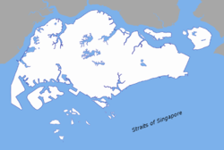
Singapore Strait is a 105-kilometer long, 16-kilometer wide
straitA strait or straits is a narrow, typically navigable channel of water that connects two larger, navigable bodies of water. It most commonly refers to a channel of water that lies between two land masses, but it may also refer to a navigable channel through a body of water that is otherwise not...
between the
Strait of MalaccaThe Strait of Malacca is a narrow, stretch of water between the Malay Peninsula and the Indonesian island of Sumatra. It is named after the Malacca Sultanate that ruled over the archipelago between 1414 to 1511.-Extent:...
in the west and the
South China SeaThe South China Sea is a marginal sea that is part of the Pacific Ocean, encompassing an area from the Singapore and Malacca Straits to the Strait of Taiwan of around...
in the east.
SingaporeSingapore , officially the Republic of Singapore, is a Southeast Asian city-state off the southern tip of the Malay Peninsula, north of the equator. An island country made up of 63 islands, it is separated from Malaysia by the Straits of Johor to its north and from Indonesia's Riau Islands by the...
is on the north of the
channelIn physical geography, a channel is the physical confine of a river, slough or ocean strait consisting of a bed and banks.A channel is also the natural or human-made deeper course through a reef, sand bar, bay, or any shallow body of water...
and the
Riau IslandsNot to be confused with Riau Islands Province, a province of Indonesia.The Riau Archipelago is the core group of islands within the Riau Islands Province in Indonesia, and located south of Singapore...
are on the south. The
Indonesia-Singapore borderThe Indonesia–Singapore border is a maritime boundary in the Straits of Singapore between Indonesia's Riau Islands which lie to the south of the border, and the islands of Singapore which lie to the north...
lies along the length of the straits.
It includes
Keppel HarbourKeppel Harbour is a stretch of water in Singapore between the mainland and the southern islands of Pulau Brani and Sentosa. Its naturally sheltered and deep waters was to meet the requirements of British colonists attempting to establish a Far East maritime colony in that part of the world, and...
and many small
islandAn island or isle is any piece of sub-continental land that is surrounded by water. Very small islands such as emergent land features on atolls can be called islets, cays or keys. An island in a river or lake may be called an eyot , or holm...
s. The strait provides the deepwater passage to the
Port of SingaporeThe Port of Singapore refers to the collective facilities and terminals that conduct maritime trade handling functions in Singapore's harbours and which handle Singapore's shipping...
, which makes it very busy.
The depth of the Singapore Strait defines the maximum draft of vessels going through the Straits of Malacca, and the
MalaccamaxMalaccamax is a naval architecture term for the largest size of ship capable of fitting through the -deep Strait of Malacca. Because the Sunda Strait is even shallower at minimum depth, a post-Malaccamax ship would need to use even longer alternate routes such as:*Lombok Strait, Makassar Strait,...
ship class.
Historical References
The 9th century AD
MuslimA Muslim, also spelled Moslem, is an adherent of Islam, a monotheistic, Abrahamic religion based on the Quran, which Muslims consider the verbatim word of God as revealed to prophet Muhammad. "Muslim" is the Arabic term for "submitter" .Muslims believe that God is one and incomparable...
author
Ya'qubiAhmad ibn Abu Ya'qub ibn Ja'far ibn Wahb Ibn Wadih al-Ya'qubi , known as Ahmad al-Ya'qubi, or Ya'qubi, was a Berber Muslim geographer.-Biography:He was a great-grandson of Wadih, the freedman of the caliph Mansur...
referred to Singapore Straits as the Sea of Salahit, one of the
Seven SeasThe phrase "Seven Seas" can refer either to a particular set of seven seas or to a great expanse of water in general. Today in modern times, this also includes the four oceans, and three large seas...
to be transversed to reach China.
Further Reading
- Borschberg, Peter, The Singapore and Melaka Straits. Violence, Security and Diplomacy in the 17th Century, Singapore and Leiden: NUS Press and KITLV Press, 2010.
- Gibson-Hill, Carl-Alexander, "Singapore: Note on the History of the Old Straits, 1580–1850", Jornal of the Malayan Branch of the Royal Asiatic Society, 27.1 (1954): 165-214.
Extent
The
International Hydrographic OrganizationThe International Hydrographic Organization is the inter-governmental organisation representing the hydrographic community. It enjoys observer status at the UN and is the recognised competent authority on hydrographic surveying and nautical charting...
defines the limits of the Singapore Strait as follows:
On the West. The Eastern limit of Malacca Strait [A line joining Tanjong PiaiTanjung Piai is a cape in Johor which is the southernmost point of Peninsular Malaysia and thus the most southern point of mainland Asia. The skyline of Singapore is visible across the Johor Strait from the point...
(Bulus), the Southern extremity of the Malay PeninsulaThe Malay Peninsula or Thai-Malay Peninsula is a peninsula in Southeast Asia. The land mass runs approximately north-south and, at its terminus, is the southern-most point of the Asian mainland...
(1°16′N 103°31′E) and The Brothers (1°11.5′N 103°21′E) and thence to Klein Karimoen (1°10′N 103°23.5′E)].
On the East. A line joining Tanjong Datok, the Southeast point of JohorJohor is a Malaysian state, located in the southern portion of Peninsular Malaysia. It is one of the most developed states in Malaysia. The state capital city and royal city of Johor is Johor Bahru, formerly known as Tanjung Puteri...
e (1°22′N 104°17′E) through Horsburgh Reef to Pulo Koko, the Northeastern extreme of Bintan Island (1°13.5′N 104°35′E).
On the North.
The Southern shore of Singapore Island, Johore Shoal and the Southeastern coast of the Malay PeninsulaThe Malay Peninsula or Thai-Malay Peninsula is a peninsula in Southeast Asia. The land mass runs approximately north-south and, at its terminus, is the southern-most point of the Asian mainland...
.
On the South. A line joining Klein Karimoen to Pulo Pemping Besar (1°06.5′N 103°47.5′E) thence along the Northern coasts of BatamBatam is an island and city in Riau Islands Province of Indonesia, known for its free trade zone area as part of the Sijori Growth Triangle, is located off Singapore's south coast...
and Bintan Islands to Pulo Koko.
See also
- Straits of Johor
The Straits of Johor is a strait that separates the Malaysian state of Johor to the north from Singapore to the south....
The source of this article is
wikipedia, the free encyclopedia. The text of this article is licensed under the
GFDL.