

List of local government areas in Scotland 1930 - 1975
Encyclopedia
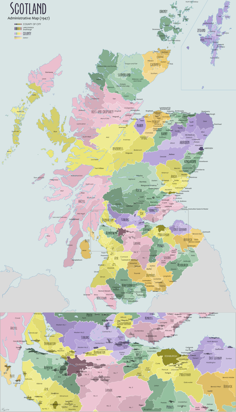
This is a list of local government areas in Scotland from 1930 to 1975.
The list contains the areas of local authorities as created by the Local Government (Scotland) Act 1929
, as amended by the Local Government (Scotland) Act 1947
. These areas were abolished in 1975 by the Local Government (Scotland) Act 1973
when a system of regions and districts replaced them. The district in which the abolished area was included is indicated.
:
The list contains the areas of local authorities as created by the Local Government (Scotland) Act 1929
Local Government (Scotland) Act 1929
The Local Government Act 1929 reorganised local government in Scotland from 1930, introducing joint county councils, large and small burghs and district councils...
, as amended by the Local Government (Scotland) Act 1947
Local Government (Scotland) Act 1947
The Local Government Act 1947 is an Act of the Parliament of the United Kingdom, that reformed local government in Scotland, on 1 October 1947....
. These areas were abolished in 1975 by the Local Government (Scotland) Act 1973
Local Government (Scotland) Act 1973
The Local Government Act 1973 is an Act of the Parliament of the United Kingdom, that reformed local government in Scotland, on May 16, 1975....
when a system of regions and districts replaced them. The district in which the abolished area was included is indicated.
Background
From 1930 to 1975 there were the following types of local government areas in ScotlandScotland
Scotland is a country that is part of the United Kingdom. Occupying the northern third of the island of Great Britain, it shares a border with England to the south and is bounded by the North Sea to the east, the Atlantic Ocean to the north and west, and the North Channel and Irish Sea to the...
:
County-level authorities
- Counties of cities: these were the four largest burghBurghA burgh was an autonomous corporate entity in Scotland and Northern England, usually a town. This type of administrative division existed from the 12th century, when King David I created the first royal burghs. Burgh status was broadly analogous to borough status, found in the rest of the United...
s: they exercised the powers of both a county council and burgh. As such they were effectively unitary authoritiesUnitary authorityA unitary authority is a type of local authority that has a single tier and is responsible for all local government functions within its area or performs additional functions which elsewhere in the relevant country are usually performed by national government or a higher level of sub-national...
. They were governed by city corporations headed by a lord provostLord ProvostA Lord Provost is the figurative and ceremonial head of one of the principal cities of Scotland. Four cities, Aberdeen, Dundee, Edinburgh and Glasgow, have the right to appoint a Lord Provost instead of a provost...
.
- Counties: There were thirty-three counties covering the area outside the counties of cities. In the case of twenty-nine counties they were governed by a county councilCounty councilA county council is the elected administrative body governing an area known as a county. This term has slightly different meanings in different countries.-United Kingdom:...
consisting partly of members nominated by the town councils of burghs in the county and partly by directly-elected councillors for the "landward" areas of the county. The chairman of a county council was known as the "convener".
- Combined counties: Two small counties, NairnshireNairn (boundaries)Nairn was a general purpose county of Scotland, with the burgh of Nairn as the county town, until 1975, when, under the Local Government Act 1973, the county area became one of the eight districts of the two-tier Highland region...
and Kinross-shireKinross-shireKinross-shire or the County of Kinross is a registration county, electoral ward and historic county in the Perth and Kinross council area in the east central Lowlands of Scotland...
were combined with the neighbouring counties of MorayMorayMoray is one of the 32 council areas of Scotland. It lies in the north-east of the country, with coastline on the Moray Firth, and borders the council areas of Aberdeenshire and Highland.- History :...
and PerthshirePerthshirePerthshire, officially the County of Perth , is a registration county in central Scotland. It extends from Strathmore in the east, to the Pass of Drumochter in the north, Rannoch Moor and Ben Lui in the west, and Aberfoyle in the south...
for most local government purposes. In these "combined counties", there was a joint county council. The separate county councils continued to exist, however, and were responsible for minor local government functions.
Sub-county authorities
- Large burghLarge burghIn 1930, the Scottish burghs were split into two types, large burghs and small burghs. The councils of large burghs had more responsibilities and power than those of small burghs....
s: The 1929 Act constituted twenty burghs as "large burghs". These towns were largely independent from the counties in which they were situated. The number of large burghs was later increased to twenty-one, with the addition of the new townNew towns in the United KingdomBelow is a list of some of the new towns in the United Kingdom created under the various New Town Acts of the 20th century. Some earlier towns were developed as Garden Cities or overspill estates early in the twentieth century. The New Towns proper were planned to disperse population following the...
of East Kilbride. The town councils of large burghs were responsible for all local services except higher-level activities such as police and education, which were provided by the county council.
- Small burghSmall burghSmall burghs were units of local government in Scotland created by the Local Government Act 1929 in 1930.The Act reclassified existing burghs into two classes, large and small burghs. While large burghs became largely independent of the county councils of the county in which they lay, small burghs...
s: The remaining burghs became "small burghs", yielding many of their powers to the reconstituted county councils.
- Landward districts: The "landward" area of each county was that part not included in a burgh. County councils were required to divide this area into districts. This was done by grouping electoral divisions (the areas for which county councillors were elected). Each district was governed by a district council consisting of ex officio the county councillors for the divisions and a number of directly elected district councillors.
Counties of cities
| Burgh | Notes | 1975 district |
|---|---|---|
| Aberdeen Aberdeen Aberdeen is Scotland's third most populous city, one of Scotland's 32 local government council areas and the United Kingdom's 25th most populous city, with an official population estimate of .... |
City of Aberdeen | |
| Dundee Dundee Dundee is the fourth-largest city in Scotland and the 39th most populous settlement in the United Kingdom. It lies within the eastern central Lowlands on the north bank of the Firth of Tay, which feeds into the North Sea... |
Extended (at the expense of Angus) in 1932, 1939, 1946 | City of Dundee |
| Edinburgh Edinburgh Edinburgh is the capital city of Scotland, the second largest city in Scotland, and the eighth most populous in the United Kingdom. The City of Edinburgh Council governs one of Scotland's 32 local government council areas. The council area includes urban Edinburgh and a rural area... |
Extended (at the expense of Midlothian) in 1954 | City of Edinburgh |
| Glasgow Glasgow Glasgow is the largest city in Scotland and third most populous in the United Kingdom. The city is situated on the River Clyde in the country's west central lowlands... |
Extended in 1931 (at the expense of Dunbartonshire and Lanarkshire) and 1938 (at the expense of Dunbartonshire, Lanarkshire and Renfrewshire) |
City of Glasgow |
Small burghs
| Burgh | Notes | 1975 district |
|---|---|---|
| Ballater Ballater Ballater is a burgh in Aberdeenshire, Scotland on the River Dee, immediately east of the Cairngorm Mountains. Situated at a height of 123m in elevation, Ballater is a centre for hikers and known for its spring water, once said to cure scrofula.-History:The medieval pattern of development along... |
Kincardine and Deeside Kincardine and Deeside Kincardine and Deeside was formerly a local government district inthe Grampian Region of Scotland.In 1996 it was included in the Aberdeenshire unitary area.-History:... |
|
| Ellon Ellon, Aberdeenshire Ellon is a town in Aberdeenshire, Scotland, approximately north of Aberdeen, lying on the River Ythan which has one of the few undeveloped river estuaries on the Eastern coast of Scotland. It is in the ancient region of Formartine... |
Gordon | |
| Fraserburgh Fraserburgh Fraserburgh is a town in Aberdeenshire, Scotland with a population recorded in the 2001 Census at 12,454 and estimated at 12,630 in 2006. It lies at the extreme northeast corner of Aberdeenshire, around north of Aberdeen, and north of Peterhead... |
Banff and Buchan Banff and Buchan Banff and Buchan is a committee area of the Aberdeenshire Council, Scotland.It has a population of 35,742 . Fishing and agriculture are important industries, together with associated processing and service activity.... |
|
| Huntly | Gordon | |
| Kintore Kintore, Aberdeenshire Kintore is a town and former royal burgh near Inverurie in Aberdeenshire, Scotland, now bypassed by the A96 road between Aberdeen and Inverness. The name Kintore comes from the Gaelic, Ceann Tòrr. Ceann means the head, or the end, and Tòrr means a round hill. So the name signifies that the town... |
Royal burgh | Gordon |
| Inverurie Inverurie Inverurie is a Royal Burgh and town in Aberdeenshire, Scotland, approximately north west of Aberdeen on the A96 road and is served by Inverurie railway station on the Aberdeen to Inverness Line... |
Royal burgh | Gordon |
| Oldmeldrum Oldmeldrum Oldmeldrum is a village and parish in the Formartine area of Aberdeenshire, not far from Inverurie in North East Scotland. With a growing population of over 2000, Oldmeldrum falls within Scotland's top 300 centres of population. The A947 road from Aberdeen to Banff runs through the centre of the... |
Gordon | |
| Peterhead Peterhead Peterhead is a town in Aberdeenshire, Scotland. It is Aberdeenshire's biggest settlement , with a population of 17,947 at the 2001 Census and estimated to have fallen to 17,330 by 2006.... |
Banff and Buchan | |
| Rosehearty Rosehearty Rosehearty , Rizarty in the local dialect, is located on the Moray Firth coast, four miles west of the town Fraserburgh, in the historical county of Aberdeenshire in Scotland.... |
Banff and Buchan | |
| Turriff Turriff Turriff is a town and civil parish in Aberdeenshire in Scotland. It is approximately above sea level, and has a population of 5,708.Turriff is known locally as Turra in the Doric dialect of Scots... |
Banff and Buchan |
Landward districts
| District | Notes | 1975 district |
|---|---|---|
| Aberdeen | Belhelvie, Bucksburn, Culter, Cults, Drumoak, Dyce, Echt, Fintar, Kinellar, Newhills, New Machar, Old Machar, Peterculter, Skene and Stoneywood areas | Most to Gordon; parts to Aberdeen (Bucksburn, Culter, Cults, Dyce, Newhills, Old Machar, Peterculter and Stoneywood) and Kincardine and Deeside (Drumoak) |
| Alford Alford, Aberdeenshire Alford is a large village in Aberdeenshire, north-east Scotland, lying just south of the River Don. It lies within the Howe of Alford which occupies the middle reaches of the River Don.... |
Alford, Auchindoir, Clatt, Glenbuchat, Keig, Kennethmont, Kildrummy, Leochel Cushnie, Strathdon, Tough, Towie and Tullynessle areas | Gordon |
| Deer | Aberdour, Crimond, Fraserburgh, Longside, Lonmay, New Deer, Old Deer, Peterhead, Pitsligo, Rathen, St Fergus, Strichen and Tyrie areas | Banff and Buchan |
| Deeside | Aboyne, Birse, Braemar, Cluny, Crathie, Cromar, Glenmuick, Kincardine O’Neil, Lumphanan and Midmar areas | Kincardine and Deeside |
| Ellon | Cruden, Ellon, Foveran, Logie Buchan, Methlick, Slains, Tarves and Udny areas | Most to Gordon; part (Cruden) to Banff and Buchan |
| Garioch | Bourtie, Chapel of Garioch, Culsalmond, Daviot, Insch, Inverurie, Keith hall, Kemnay, Kintore, Leslie, Meldrum, Monymusk, Oyne, Premnay and Rayne areas | Gordon |
| Huntly | Cairnie, Drumblade, Forgue, Gartly, Glass, Huntly and Rhynie areas | Gordon |
| Turriff | Auchterless, Fyvie, King Edward, Monquhitter and Turriff areas | Banff and Buchan |
Large burgh
| Burgh | Notes | 1975 district |
|---|---|---|
| Arbroath Arbroath Arbroath or Aberbrothock is a former royal burgh and the largest town in the council area of Angus in Scotland, and has a population of 22,785... |
Royal burgh | Angus Angus Angus is one of the 32 local government council areas of Scotland, a registration county and a lieutenancy area. The council area borders Aberdeenshire, Perth and Kinross and Dundee City... |
Small burghs
| Burgh | Notes | 1975 district |
|---|---|---|
| Brechin Brechin Brechin is a former royal burgh in Angus, Scotland. Traditionally Brechin is often described as a city because of its cathedral and its status as the seat of a pre-Reformation Roman Catholic diocese , but that status has not been officially recognised in the modern era... |
Royal burgh | Angus |
| Carnoustie Carnoustie Carnoustie is a town and former police burgh in the council area of Angus, Scotland. It is situated at the mouth of the Barry Burn on the North Sea coast... |
Angus | |
| Forfar Forfar Forfar is a parish, town and former royal burgh of approximately 13,500 people in Angus, located in the East Central Lowlands of Scotland. Forfar is the county town of Angus, which was officially known as Forfarshire from the 18th century until 1929, when the ancient name was reinstated, and... |
Royal burgh | Angus |
| Kirriemuir Kirriemuir Kirriemuir, sometimes called Kirrie, is a burgh in Angus, Scotland.-History:The history of Kirriemuir extends to the early historical period and it appears to have been a centre of some ecclesiastical importance... |
Angus | |
| Monifieth Monifieth Monifieth is a town and former police burgh in the council area of Angus, Scotland. It is situated on the North bank of the Firth of Tay on the East Coast... |
Dundee Dundee Dundee is the fourth-largest city in Scotland and the 39th most populous settlement in the United Kingdom. It lies within the eastern central Lowlands on the north bank of the Firth of Tay, which feeds into the North Sea... |
|
| Montrose Montrose, Angus Montrose is a coastal resort town and former royal burgh in Angus, Scotland. It is situated 38 miles north of Dundee between the mouths of the North and South Esk rivers... |
Royal burgh | Angus |
Landward districts
| District | Notes | 1975 district |
|---|---|---|
| Brechin | Brechin, Careston, Dun, Edzell, Lethnot, Lochlee, Logie Pert, Menmuir and Stracathro areas | Angus |
| Carnoustie | Arbirlot, Arbroath, Barry, Carmyllie, Monikie, Panbride and St Vigeans areas | Angus |
| Forfar | Aberlemno, Dunnichen, Eassie, Forfar, Glamis, Guthrie, Inverarity, Kinnettles, Kirkden, Oathlaw and Rescobie areas | Angus |
| Kirriemuir | Airlie, Clova, Cotachy, Fern, Glenisla, Kingoldrum, Kirriemuir, Lintrathen, Ruthven and Tannadice areas | Angus |
| Monifieth | Auchterhouse, Benvie, Fowlis Easter, Kettins, Liff, Lundie, Mains, Monifieth, Murroes, Newtyle, Strathmartine and Tealing areas | Most to Dundee; part (Newtyle) to Angus, part (Kettins) to Perth and Kinross |
| Montrose | Craig, Farnell, Inverkeilor, Kinnell, Lunan, Maryton and Montrose areas | Angus |
Small burghs
| Burgh | Notes | 1975 district |
|---|---|---|
| Campbeltown Campbeltown Campbeltown is a town and former royal burgh in Argyll and Bute, Scotland. It lies by Campbeltown Loch on the Kintyre peninsula. Originally known as Kinlochkilkerran , it was renamed in the 17th century as Campbell's Town after Archibald Campbell was granted the site in 1667... |
Royal burgh | Argyll and Bute Argyll and Bute Argyll and Bute is both one of 32 unitary council areas; and a Lieutenancy area in Scotland. The administrative centre for the council area is located in Lochgilphead.Argyll and Bute covers the second largest administrative area of any Scottish council... |
| Dunoon Dunoon Dunoon is a resort town situated on the Cowal Peninsula in Argyll, Scotland. It sits on the Firth of Clyde to the south of Holy Loch and to the west of Gourock.-Waterfront:... |
Argyll and Bute | |
| Inveraray Inveraray Inveraray is a royal burgh in Argyll and Bute, Scotland. It is on the western shore of Loch Fyne, near its head, and on the A83 road. It is the traditional county town of Argyll and ancestral home to the Duke of Argyll.-Coat of arms:... |
Royal burgh | Argyll and Bute |
| Lochgilphead Lochgilphead Lochgilphead is a town and former burgh in Scotland, with a population of around 3,000 people. It is the administrative centre of Argyll and Bute. The town lies at the end of Loch Gilp and lies on the banks of the Crinan Canal.... |
Argyll and Bute | |
| Oban Oban Oban Oban Oban ( is a resort town within the Argyll and Bute council area of Scotland. It has a total resident population of 8,120. Despite its small size, it is the largest town between Helensburgh and Fort William and during the tourist season the town can be crowded by up to 25,000 people. Oban... |
Argyll and Bute | |
| Tobermory | Argyll and Bute |
Landward districts
| District | Notes | 1975 district |
|---|---|---|
| Ardnamurchan Ardnamurchan Ardnamurchan is a peninsula in Lochaber, Highland, Scotland, noted for being very unspoilt and undisturbed. Its remoteness is accentuated by the main access route being a single track road for much of its length.-Geography:... |
Ardgour, Ardnamurchan, Morvem and Sunart areas | Lochaber Lochaber District of Lochaber 1975 to 1996Highland council area shown as one of the council areas of ScotlandLochaber is one of the 16 ward management areas of the Highland Council of Scotland and one of eight former local government districts of the two-tier Highland region... |
| Coll Coll Coll is a small island, west of Mull in the Inner Hebrides of Scotland. Coll is known for its sandy beaches, which rise to form large sand dunes, for its corncrakes, and for Breachacha Castle.-Geography and geology:... |
Coll | Combined with Tiree District in 1932 |
| Cowal Cowal thumb|Cowal shown within ArgyllCowal is a peninsula in Argyll and Bute in the Scottish Highlands.-Description:The northern part of Cowal is mostly the mountainous Argyll Forest Park. Cowal is separated from the Kintyre peninsula to the west by Loch Fyne, and from Inverclyde and North Ayrshire to... |
Innellan, Inverchaolain, Kilfinan, Kilmun, Kilmodan, Lochgoilhead, Sandbank, and Strachur & Strathlachlan areas | Argyll and Bute |
| Islay Islay -Prehistory:The earliest settlers on Islay were nomadic hunter-gatherers who arrived during the Mesolithic period after the retreat of the Pleistocene ice caps. In 1993 a flint arrowhead was found in a field near Bridgend dating from 10,800 BC, the earliest evidence of a human presence found so far... |
Kilarrow, Kilchoman, Kildalton, Kilmeny, Port Ellen and Portnahaven areas | Argyll and Bute |
| Jura Jura, Scotland Jura is an island in the Inner Hebrides of Scotland, situated adjacent and to the north-east of Islay. Part of the island is designated as a National Scenic Area. Until the twentieth century Jura was dominated - and most of it was eventually owned - by the Campbell clan of Inveraray Castle on Loch... and Colonsay Colonsay Colonsay is an island in the Scottish Inner Hebrides, located north of Islay and south of Mull and has an area of . It is the ancestral home of Clan Macfie and the Colonsay branch of Clan MacNeill. Aligned on a south-west to north-east axis, it measures in length and reaches at its widest... |
Colonsay, Jura and Oronsay Oronsay This is a list of islands called Oronsay , which provides an index for islands in Scotland with this and similar names. It is one of the more common names for Scottish islands. The names come from Örfirisey which translates from Old Norse as "tidal" or "ebb island"... |
Argyll and Bute |
| Kintyre Kintyre Kintyre is a peninsula in western Scotland, in the southwest of Argyll and Bute. The region stretches approximately 30 miles , from the Mull of Kintyre in the south, to East Loch Tarbert in the north... |
Campbeltown, Kilcalmonell & Gigha, Killetan & Kilkenzie, Saddell & Skipness, Southend and Tarbert areas | Argyll and Bute |
| Mid Argyll | Craignish, Glenaray, Kilberry, Kilmartin, Kilmichael, Lochfyne, North Knapdale and South Knapdale areas | Argyll and Bute |
| Mull Isle of Mull The Isle of Mull or simply Mull is the second largest island of the Inner Hebrides, off the west coast of Scotland in the council area of Argyll and Bute.... |
Kilfinichen & Kilvickeon, Kilninian & Kilmore and Torosay areas | Argyll and Bute |
| North Lorn | Ardchattan, Ballachulish, Kinlochleven and Lismore & Appin areas | Most to Argyll and Bute; part (Ballachulish Ballachulish The village of Ballachulish in Lochaber, Highland, Scotland, is centred around former slate quarries. The name Ballachulish was more correctly applied to the area now called North Ballachulish, to the north of Loch Leven, but was usurped for the quarry villages at East Laroch and West Laroch,... and Kinlochleven Kinlochleven Kinlochleven is a village in Lochaber, in the Scottish Highlands and lies at the eastern end of Loch Leven, a sea loch cutting into the western Scottish Highlands. To the north lie the Mamores ridge; to the south lie the mountains flanking Glen Coe... ) to Lochaber |
| South Lorn | Glenorchy & Innishael, Kilbrandon & Kilchattan, Kilchrenan & Dalavich, Kilmore & Kilbride, Kilninver & Kilmelford and Muckairn areas | Argyll and Bute |
| Tiree | Tiree | Combined with Coll District in 1932 |
| Tiree Tiree -History:Tiree is known for the 1st century BC Dùn Mòr broch, for the prehistoric carved Ringing Stone and for the birds of the Ceann a' Mhara headland.... and Coll Coll Coll is a small island, west of Mull in the Inner Hebrides of Scotland. Coll is known for its sandy beaches, which rise to form large sand dunes, for its corncrakes, and for Breachacha Castle.-Geography and geology:... |
Formed 1932 by merger of two districts. Tiree, Coll |
Argyll and Bute |
Large burghs
| Burgh | Notes | 1975 district |
|---|---|---|
| Ayr Ayr Ayr is a town and port situated on the Firth of Clyde in south-west Scotland. With a population of around 46,000, Ayr is the largest settlement in Ayrshire, of which it is the county town, and has held royal burgh status since 1205... |
Royal burgh | Kyle and Carrick Kyle and Carrick Kyle and Carrick was one of nineteen local government districts in the Strathclyde region of Scotland from 1975 to 1996.... |
| Kilmarnock Kilmarnock Kilmarnock is a large burgh in East Ayrshire, Scotland, with a population of 44,734. It is the second largest town in Ayrshire. The River Irvine runs through its eastern section, and the Kilmarnock Water passes through it, giving rise to the name 'Bank Street'... |
Kilmarnock and Loudoun Kilmarnock and Loudoun (Scottish Parliament constituency) Kilmarnock and Loudoun was a constituency of the Scottish Parliament . It elected one Member of the Scottish Parliament by the plurality method of election.... |
Small burghs
| Burgh | Notes | 1975 district |
|---|---|---|
| Ardrossan Ardrossan Ardrossan is a town on the North Ayrshire coast in south-western Scotland. The name "Ardrossan" describes its physical position — 'ard' from the Gaelic àird meaning headland, 'ros' a promontory and the diminutive suffix '-an' - headland of the little promontory... |
Cunninghame Cunninghame Cunninghame is a former comital district of Scotland and also a district of the Strathclyde Region from 1975–1996.-Historic Cunninghame:The historic district of Cunninghame was bordered by the districts of Renfrew and Clydesdale to the north and east respectively, by the district of Kyle to the... |
|
| Cumnock and Holmhead Cumnock Cumnock is a town in East Ayrshire, Scotland. The town sits at the confluence of the Glaisnock Water and the Lugar Water... |
Cumnock and Doon Valley Cumnock and Doon Valley Cumnock and Doon Valley was one of nineteen local government districts in the Strathclyde region of Scotland from 1973 to 1996.... |
|
| Darvel Darvel Darvel is a small town in East Ayrshire, Scotland, located at the eastern end of the Irvine Valley and is sometimes referred to as "The Lang Toon" due to its quaint appearance on Ordnance Survey maps.... |
Kilmarnock and Loudoun | |
| Galston Galston, East Ayrshire Galston is a town in East Ayrshire, Scotland which has a population of 5000 . It is situated in wooded countryside 4 miles up-river from Kilmarnock and is one a group of the small towns located in the Irvine Valley between the towns of Hurlford and Newmilns. Galston is located in the Loudoun area... |
Kilmarnock and Loudoun | |
| Girvan Girvan Girvan is a burgh in Carrick, South Ayrshire, Scotland, with a population of about 8000 people. Originally a fishing port, it is now also a seaside resort with beaches and cliffs. Girvan dates back to 1668 when is became a municipal burgh incorporated by by charter... |
Kyle and Carrick | |
| Irvine Irvine, North Ayrshire Irvine is a new town on the coast of the Firth of Clyde in North Ayrshire, Scotland. According to 2007 population estimates, the town is home to 39,527 inhabitants, making it the biggest settlement in North Ayrshire.... |
Royal burgh | Cunninghame |
| Kilwinning Kilwinning Kilwinning is a historic town in North Ayrshire, Scotland. It is known as The Crossroads of Ayrshire. The 2001 Census recorded it as having a population of 15,908.-History:... |
Cunninghame | |
| Largs Largs Largs is a town on the Firth of Clyde in North Ayrshire, Scotland, about from Glasgow. The original name means "the slopes" in Scottish Gaelic.... |
Cunninghame | |
| Maybole Maybole Maybole is a burgh of barony and police burgh of South Ayrshire, Scotland. Pop. 4,552. It is situated south of Ayr and southwest of Glasgow by the Glasgow and South Western Railway. ... |
Kyle and Carrick | |
| Newmilns and Greenholm Newmilns Newmilns and Greenholm is a small burgh in East Ayrshire, Scotland. It has a population of 3,057 people and lies on the A71, around seven miles east of Kilmarnock and twenty-five miles southwest of Glasgow... |
Kilmarnock and Loudoun | |
| Prestwick Prestwick Prestwick is a town in South Ayrshire on the south-west coast of Scotland, about south-west of Glasgow. It adjoins the larger town of Ayr, the centre of which is about south... |
Kyle and Carrick | |
| Saltcoats Saltcoats - References :*McSherry, R. & M. . Old Saltcoats, Stenlake Publishing, Ochiltree. ISBN 1-872074-57-X.*Stansfield, G. . Ayrshire & Renfrewshire's Lost Railways, Stenlake Publishing, Catrine. ISBN 1-84033-077-5.-External links:***... |
Cunninghame | |
| Stewarton Stewarton Stewarton is a town in East Ayrshire, Scotland. In comparison to the neighbouring towns of Kilmaurs, Fenwick, Dunlop and Lugton, it is a relatively large town, with a population of over 6,500. It is 300 feet above sea level.Groome, Francis H. . Ordnance Gazetteer of Scotland. Pub. Caxton. London.... |
Kilmarnock and Loudoun | |
| Troon Troon Troon is a town in South Ayrshire. It is situated on the west coast of Scotland, about eight miles north of Ayr and three miles northwest of Glasgow Prestwick International Airport. Lying across the Firth of Clyde, the Isle of Arran can be seen. Troon is also a port with freight and ferry services... |
Kyle and Carrick | |
| Stevenston Stevenston Stevenston is a town in North Ayrshire, Scotland. It is one of the 'Three Towns' along with Ardrossan and Saltcoats.-History:The town is named after Stephan Loccard or Lockhart, whose father obtained a grant of land from Richard de Morville, Lord Cunninghame and Constable of Scotland, around 1170.... |
Burgh created 1952 | Cunninghame |
Landward districts
| District | Notes | 1975 district |
|---|---|---|
| Ayr (No.1) Renamed Ayr |
Ayr, Dundonald, Monkton, Craigie & Symington and Tarbolton areas | Kyle and Carrick, part to Cunninghame |
| Cumnock | Auchinleck, Mauchline, Muirkirk, New Cumnock, Old Cumnock, Sorn and Stair & Ochiltree areas | Cumnock and Doon Valley |
| Ayr (No.2) Renamed Dalmellington Dalmellington Dalmellington is a market town in Ayrshire, Scotland. In 2001 it had a population of 1407. The town owes its origins to the fault line separating the Southern Uplands of Scotland from the Central Lowlands... |
Coylton, Dalmellington and Dalrymple areas | Cumnock and Doon Valley, part (Coylton) to Kyle and Carrick |
| Girvan | Ballantrae, Barr, Barrhill, Colmonell, Dailly and Girvan areas | Kyle and Carrick |
| Irvine | Dreghorn, Irvine and Kilwinning areas | Cunninghame |
| Kilbirnie Kilbirnie Kilbirnie is a small town of 7280 inhabitants situated in North Ayrshire on the west coast of Scotland... |
Beith, Dalry and Kilbirnie areas | Cunninghame |
| Kilmarnock | Dunlop & Stewarton, Fenwick & Kilmarnock, Kilmaurs and Riccarton areas Absorbed Newmilns District |
Kilmarnock and Loudoun, part to Cunninghame |
| Maybole | Kirkmichael & Straiton, Kirkoswald and Maybole areas | Kyle and Carrick |
| Newmilns | Galston and Loudoun areas in existence 1970, absorbed by Kilmarnock District by 1975 |
N/A |
| Saltcoats | Largs, Stevenston & Ardrossan and West Kilbride areas Renamed West Kilbride on formation of burgh of Stevenston 1952. |
Cunninghame |
Small burghs
| Burgh | Notes | 1975 district |
|---|---|---|
| Aberchirder Aberchirder Aberchirder , known locally as Foggieloan or Foggie, is a village in Aberdeenshire, Scotland, situated on the A97 road six miles west of Turriff.- History :... |
Banff and Buchan | |
| Aberlour Aberlour Aberlour , is the name of a place in Moray, Scotland, 12 miles south of Elgin on the road to Grantown. A burn , a tributary of the River Spey, and surrounding parish, are both named Aberlour, but the name is most commonly used in reference to the village which straddles the stream and flanks the... |
Moray Moray Moray is one of the 32 council areas of Scotland. It lies in the north-east of the country, with coastline on the Moray Firth, and borders the council areas of Aberdeenshire and Highland.- History :... |
|
| Banff Banff, Aberdeenshire Banff is a town in the Banff and Buchan area of Aberdeenshire, Scotland. Banff is situated on Banff Bay and faces the town of Macduff across the estuary of the River Deveron... |
Royal burgh | Banff and Buchan |
| Buckie Buckie Buckie is a burgh town on the Moray Firth coast of Scotland in Moray. Buckie was the largest town in Banffshire by some thousands of inhabitants before regionalisation in 1975 removed that political division from the map of Scotland... |
Moray | |
| Cullen | Royal burgh | Moray |
| Dufftown Dufftown Dufftown is a burgh in Banffshire, Scotland.The town was originally named Mortlach in the Middle Ages, until the 19th century when the Earl of Fife built the town as a housing for soldiers returning home from war... |
Moray | |
| Findochty Findochty Findochty is a village in Banffshire, Scotland, 4 miles east of the town of Buckie.Findochty stands on the shores of the Moray Firth. The Gaelic name of the village was recorded by Diack in his own transcription method as fanna-guchti which is unclear in meaning... |
Moray | |
| Keith Keith, Moray Keith is a small town in the Moray council area in north east Scotland. It has a population of around 4,500.... |
Moray | |
| Macduff Macduff, Aberdeenshire Macduff is a town in the Banff and Buchan area of Aberdeenshire, Scotland. Macduff is situated on Banff Bay and faces the town of Banff across the estuary of the River Deveron... |
Banff and Buchan | |
| Portknockie Portknockie Portknockie is a coastal village on the Moray Firth in northeast Scotland, in Moray. Portknockie is a coastal village on the Moray Firth in northeast Scotland, in Moray. Portknockie is a coastal village on the Moray Firth in northeast Scotland, in Moray. (Family historians will note that this... |
Moray | |
| Portsoy Portsoy Portsoy is a burgh in Aberdeenshire, Scotland, formerly in the county of Banffshire. The original name of the town was Pert Soaidh, which translates as 'The wooded place of the warriors... |
Banff and Buchan |
Landward districts
| District | Notes | 1975 district |
|---|---|---|
| Aberchirder | Forglen, Inverkeithny, Marnoch and Ordiquihill areas | Banff and Buchan |
| Banff | Alvah, Banff, Boyndie, Gamrie and Gardenstown areas | Banff and Buchan |
| Buckie | Portgordon and Rathven areas | Moray |
| Cullen | Cullen, Deskford and Fordyce areas | Most to Moray; part (Fordyce) to Banff and Buchan |
| Dufftown | Aberlour, Cabrach, Inveravon, Kirkmichael and Mortlach areas | Moray |
| Keith | Boharm, Botriphnie, Grange, Keith and Rothiemay areas | Moray |
Small burghs
| Burgh | Notes | 1975 district |
|---|---|---|
| Coldstream Coldstream Coldstream is a small town in the Borders district of Scotland. It lies on the north bank of the River Tweed in Berwickshire, while Northumberland in England lies to the south bank, with Cornhill-on-Tweed the nearest village... |
Berwickshire Berwickshire Berwickshire or the County of Berwick is a registration county, a committee area of the Scottish Borders Council, and a lieutenancy area of Scotland, on the border with England. The town after which it is named—Berwick-upon-Tweed—was lost by Scotland to England in 1482... |
|
| Duns Duns Duns is the county town of the historic county of Berwickshire, within the Scottish Borders.-Early history:Duns law, the original site of the town of Duns, has the remains of an Iron Age hillfort at its summit... |
Berwickshire | |
| Eyemouth Eyemouth Eyemouth , historically spelt Aymouth, is a small town and civil parish in Berwickshire, in the Scottish Borders area of Scotland. It is east of the main north-south A1 road and just north of Berwick-upon-Tweed. It has a population of circa 3,420 people .The town's name comes from its location at... |
Berwickshire | |
| Lauder Lauder The Royal Burgh of Lauder is a town in the Scottish Borders 27 miles south east of Edinburgh. It is also a royal burgh in the county of Berwickshire. It lies on the edge of the Lammermuir Hills, on the Southern Upland Way.-Medieval history:... |
Royal burgh | Ettrick and Lauderdale Ettrick and Lauderdale Ettrick & Lauderdale 1975-96Ettrick and Lauderdale was one of four local government districts in the Borders region of Scotland from 1975 to 1996.... |
Landward districts
| District | Notes | 1975 district |
|---|---|---|
| East | Abbey St Bathans & Bunkle, Ayton, Burnmouth, Chirnside, Cockburnspath, Coldingham, Foulden & Mordington, Hutton and Reston areas | Berwickshire Berwickshire Berwickshire or the County of Berwick is a registration county, a committee area of the Scottish Borders Council, and a lieutenancy area of Scotland, on the border with England. The town after which it is named—Berwick-upon-Tweed—was lost by Scotland to England in 1482... |
| Middle | Coldstream, Cranshaws Cranshaws Cranshaws is a village on the B6355, near Duns, in the Scottish Borders area of Scotland, in the former Berwickshire.Of Cranshaws Castle only the tower remains, at Cranshaws Farm on Cranshaws Hill.... & Longformacus, Duns, Eccles, Edrom, Fogo & Polwarth, Greenlaw, Ladykirk & Whitsome, Langton, Leitholm, and Swinton areas |
Berwickshire |
| West | Channelkirk, Earlston, Gordon, Hume & Nenthorn, Lauder, Legerwood, Mertoun and Westruther areas | Most to Ettrick and Lauderdale; part (Gordon, Hume and Westruther) to Berwickshire; part (Nenthorn) to Roxburgh Roxburgh Roxburgh , also known as Rosbroch, is a village, civil parish and now-destroyed royal burgh. It was an important trading burgh in High Medieval to early modern Scotland... |
Small burghs
| Burgh | Notes | 1975 district |
|---|---|---|
| Rothesay Rothesay, Argyll and Bute The town of Rothesay is the principal town on the Isle of Bute, in the council area of Argyll and Bute, Scotland. It can be reached by ferry from Wemyss Bay which offers an onward rail link to Glasgow. At the centre of the town is Rothesay Castle, a ruined castle which dates back to the 13th... |
Royal burgh | Argyll and Bute Argyll and Bute Argyll and Bute is both one of 32 unitary council areas; and a Lieutenancy area in Scotland. The administrative centre for the council area is located in Lochgilphead.Argyll and Bute covers the second largest administrative area of any Scottish council... |
| Millport Millport, Isle of Cumbrae Millport is the only town on the island of Great Cumbrae in the Firth of Clyde off the coast of North Ayrshire, Scotland. The town is four miles south from the Largs-based Caledonian MacBrayne ferry slipway.... |
Cunninghame Cunninghame Cunninghame is a former comital district of Scotland and also a district of the Strathclyde Region from 1975–1996.-Historic Cunninghame:The historic district of Cunninghame was bordered by the districts of Renfrew and Clydesdale to the north and east respectively, by the district of Kyle to the... |
Landward districts
| District | Notes | 1975 district |
|---|---|---|
| Arran Isle of Arran Arran or the Isle of Arran is the largest island in the Firth of Clyde, Scotland, and with an area of is the seventh largest Scottish island. It is in the unitary council area of North Ayrshire and the 2001 census had a resident population of 5,058... |
Island of Arran, Holy Island and Pladda Island | Cunninghame |
| Bute Isle of Bute Bute is an island in the Firth of Clyde in Scotland. Formerly part of the county of Buteshire, it now constitutes part of the council area of Argyll and Bute. Its resident population was 7,228 in April 2001.-Geography:... |
Islands of Bute and Inchmarnock | Argyll and Bute |
| Cumbrae Great Cumbrae Great Cumbrae is the larger of the two islands known as The Cumbraes in the lower Firth of Clyde in western Scotland... |
Islands of Great Cumbrae and Little Cumbrae | Cunninghame |
Small burghs
| Burgh | Notes | 1975 district |
|---|---|---|
| Wick Wick, Highland Wick is an estuary town and a royal burgh in the north of the Highland council area of Scotland. Historically, it is one of two burghs within the county of Caithness, of which Wick was the county town. The town straddles the River Wick and extends along both sides of Wick Bay... |
Royal burgh | Caithness Caithness Caithness is a registration county, lieutenancy area and historic local government area of Scotland. The name was used also for the earldom of Caithness and the Caithness constituency of the Parliament of the United Kingdom . Boundaries are not identical in all contexts, but the Caithness area is... |
| Thurso Thurso -Facilities:Offices of the Highland Council are located in the town, as is the main campus of North Highland College, formerly Thurso College. This is one of several partner colleges which constitute the UHI Millennium Institute, and offers several certificate, diploma and degree courses from... |
Caithness |
Landward districts
| District | Notes | 1975 district |
|---|---|---|
| Central | Bower, Castletown and Olrig areas | Caithness |
| Eastern | Keiss, Watten and Wick areas | Caithness |
| Northern | Canisbay and Dunnet areas | Caithness |
| Southern | Berriedale, Clyth, Dunbeath, Latheron and Lybster areas | Caithness |
| Western | Halkirk, Reay and Thurso areas | Caithness |
Small burghs
| Burgh | Notes | 1975 district |
|---|---|---|
| Alloa Alloa Alloa is a town and former burgh in Clackmannanshire, set in the Central Lowlands of Scotland. It lies on on the north bank of the Firth of Forth close to the foot of the Ochil Hills, east of Stirling and north of Falkirk.... |
Clackmannan Clackmannanshire Clackmannanshire, often abbreviated to Clacks is a local government council area in Scotland, and a lieutenancy area, bordering Perth and Kinross, Stirling and Fife.As Scotland's smallest historic county, it is often nicknamed 'The Wee County'.... |
|
| Alva Alva, Clackmannanshire Alva is a small town in Clackmannanshire, set in the Central Lowlands of Scotland. It is one of a number of towns situated immediately to the south of the Ochil Hills, collectively referred to as the Hillfoots Villages or simply The Hillfoots... |
Clackmannan | |
| Dollar Dollar, Clackmannanshire Dollar is a small town in Clackmannanshire, Scotland. It is one of the Hillfoots Villages, situated between the Ochil Hills range to the north and the River Devon to the south. Dollar is on the A91 road, which runs from Stirling to St. Andrews. The town is around 3 miles east of Tillicoultry... |
Clackmannan | |
| Tillicoultry Tillicoultry Tillicoultry... |
Clackmannan |
Landward districts
| District | Notes | 1975 district |
|---|---|---|
| Alloa | Alloa and Clackmannan areas | Clackmannan |
| Hillfoots Hillfoots Villages The Hillfoots Villages are the villages and small towns which lie at the base of the southern scarp face of the Ochil Hills, formed by the Ochil Fault, in Stirlingshire and Clackmannanshire in central Scotland.... |
Alva, Tillicoultry and Dollar areas | Clackmannan |
Large burgh
| Burgh | Notes | 1975 district |
|---|---|---|
| Dumfries Dumfries Dumfries is a market town and former royal burgh within the Dumfries and Galloway council area of Scotland. It is near the mouth of the River Nith into the Solway Firth. Dumfries was the county town of the former county of Dumfriesshire. Dumfries is nicknamed Queen of the South... |
Royal burgh | Nithsdale Nithsdale Nithsdale , also known by its anglicised gaelic name Strathnith or Stranit, is the valley of the River Nith in Scotland, and the name of the region... |
Small burghs
| Burgh | Notes | 1975 district |
|---|---|---|
| Annan Annan, Dumfries and Galloway The royal burgh of Annan is a well-built town, red sandstone being the material mainly used. Each year in July, Annan celebrates the Royal Charter and the boundaries of the Royal Burgh are confirmed when a mounted cavalcade undertakes the Riding of the Marches. Entertainment includes a... |
Royal burgh | Annandale and Eskdale Annandale and Eskdale Annandale and Eskdale is a committee area in Dumfries and Galloway, Scotland. It covers the areas of Annandale and Eskdale, the straths of the River Annan and the River Esk respectively.... |
| Langholm Langholm Langholm , also known colloquially as the "Muckle Toon", is a burgh in Dumfries and Galloway, Scotland, on the River Esk and the A7 road.- History:... |
Annandale and Eskdale | |
| Lochmaben Lochmaben Lochmaben is a small town in Scotland, and site of a once-important castle. It lies four miles west of Lockerbie, in Dumfries and Galloway.-Notable people:*Angus Douglas - Scottish internationalist footballer... |
Royal burgh | Annandale and Eskdale |
| Lockerbie Lockerbie Lockerbie is a town in the Dumfries and Galloway region of south-western Scotland. It lies approximately from Glasgow, and from the English border. It had a population of 4,009 at the 2001 census... |
Annandale and Eskdale | |
| Moffat Moffat Moffat is a former burgh and spa town in Dumfries and Galloway, Scotland, lying on the River Annan, with a population of around 2,500. The most notable building in the town is the Moffat House Hotel, designed by John Adam... |
Annandale and Eskdale | |
| Sanquhar Sanquhar Sanquhar is a town on the River Nith in Dumfries and Galloway, Scotland. It lies north of Thornhill and west of Moffat. It is a Royal Burgh.Sanquhar is notable for its tiny post office , claimed to be the oldest working post office in the world... |
Nithsdale |
Landward districts
| District | Notes | 1975 district |
|---|---|---|
| Annan | Annan, Cummertrees, Dornock and Eastriggs areas | Annandale and Eskdale |
| Dumfries | Caerlaverock, Dalton, Dumfries, Dunscore (west), Holywood, Kirkmahoe, Kirkmichael, Lochmaben, Mouswald, Ruthwell, Torthorwald and Tinwald areas |
Most to Nithsdale; part (Dalton and Lochmaben) to Annandale and Eskdale |
| Gretna | Gretna, Half Morton, Kirkpatrick Fleming and Middlebie areas | Annandale and Eskdale |
| Langholm | Canonbie, Eskdalemuir, Ewes, Langholm and Westerkirk areas | Annandale and Eskdale |
| Lockerbie | Applegarth, Corrie, Dryfesdale, Hoddom, Hutton, Johnstone, St Mungo and Tundergarth areas | Annandale and Eskdale |
| Moffat | Kirkpatrick Juxta, Moffat and Wamphray areas | Annandale and Eskdale |
| Thornhill Thornhill, Dumfries and Galloway Thornhill is a town in the Mid Nithsdale area of Dumfries and Galloway, Scotland, south of Sanquhar and north of Dumfries.A monument to the explorer Joseph Thomson , who lived in neighbouring Penpont and Gatelawbridge, can be found close to the school... |
Closeburn, Dunscore (east), Durisdeer, Glencairn, Keir, Morton, Penpont, Thornhill and Tynron areas | Nithsdale |
| Sanquhar, renamed Upper Nithsdale |
Kirkconnel and Sanquhar areas | Nithsdale |
Large burghs
| Burgh | Notes | 1975 district |
|---|---|---|
| Dumbarton | Royal burgh | Dumbarton |
| Clydebank Clydebank Clydebank is a town in West Dunbartonshire, in the Central Lowlands of Scotland. Situated on the north bank of the River Clyde, Clydebank borders Dumbarton, the town with which it was combined to form West Dunbartonshire, as well as the town of Milngavie in East Dunbartonshire, and the Yoker and... |
Clydebank |
Small burghs
| Burgh | Notes | 1975 district |
|---|---|---|
| Bearsden Bearsden Bearsden ) is a town in East Dunbartonshire, Scotland. It lies on the northwestern fringe of Greater Glasgow, approximately from the City Centre, and is effectively a suburb, with housing development coinciding with the introduction of a railway line in 1863, and from where the town gets its name... |
Created 1958 | Bearsden and Milngavie Bearsden and Milngavie Bearsden and Milngavie was formerly one of nineteen local government districts in the Strathclyde region of Scotland, north of the City of Glasgow.... |
| Cove and Kilcreggan Cove, Argyll and Bute Cove is a village in Argyll and Bute, Scotland.It is on the south-west of the Rosneath peninsula, on the east shore of Loch Long.Before the local government reorganisation in Scotland in 1975 it formed part of the small Joint Burgh of Cove and Kilcreggan, in the County of Dumbarton.In common with... |
Dumbarton | |
| Cumbernauld Cumbernauld Cumbernauld is a Scottish new town in North Lanarkshire. It was created in 1956 as a population overspill for Glasgow City. It is the eighth most populous settlement in Scotland and the largest in North Lanarkshire... |
Created 1968 | Cumbernauld and Kilsyth Cumbernauld and Kilsyth Cumbernauld and Kilsyth 1975-96Cumbernauld and Kilsyth was formerly one of nineteen local government districts in the Strathclyde region of Scotland.... |
| Helensburgh Helensburgh Helensburgh is a town in Argyll and Bute, Scotland. It lies on the north shore of the Firth of Clyde and the eastern shore of the entrance to the Gareloch.... |
Dumbarton | |
| Kirkintilloch Kirkintilloch Kirkintilloch is a town and former burgh in East Dunbartonshire, Scotland. It lies on the Forth and Clyde Canal, about eight miles northeast of central Glasgow... |
Strathkelvin Strathkelvin Strathkelvin is the strath of the River Kelvin in west central Scotland, close to the city of Glasgow. The name Strathkelvin was formerly used for one of nineteen local government districts in the Strathclyde region of Scotland.-District :The district of Strathkelvin was formed by the Local... |
|
| Milngavie Milngavie Milngavie , is a town in East Dunbartonshire, Scotland. It is on the Allander Water, at the northwestern edge of Greater Glasgow, and about from Glasgow city centre. It neighbours Bearsden.... |
Bearsden and Milngavie |
Landward districts
| District | Notes | 1975 district |
|---|---|---|
| Cumbernauld | Condorrat and Cumbernauld areas. Combined with Kirkintilloch District 1968 on creation of Cumbernauld Burgh |
N/A |
| Cumbernauld and Kirkintilloch | Croy, Dullatur, Twechar and Waterside areas Created 1968 |
Most to Cumbernauld and Kilsyth; part to Strathkelvin (parts of Twechar and Waterside) |
| Helensburgh | Arrochar, Cardross, Craigendoran, Garelochhead, Rhu, Rosneath and Shandon areas | Dumbarton |
| Kirkintilloch | Twechar and Waterside areas Combined with Cumbernauld district in 1968 |
N/A |
| New Kilpatrick New Kilpatrick New Kilpatrick, is an ecclesiastical Parish and former Civil Parish in Dunbartonshire. It was formed in 1649 from the eastern half of the parish of Kilpatrick , the western half forming Old Kilpatrick... |
Garscadden, Millichen and New Kilpatrick areas Dissolved 1958 on creation of Bearsden Burgh |
N/A |
| Old Kilpatrick Old Kilpatrick Old Kilpatrick is a village in West Dunbartonshire, Scotland.The village is on the north bank of the River Clyde immediately to the north of the Forth and Clyde Canal, three miles from Clydebank on the road to Dumbarton. The Great Western Road runs through Old Kilpatrick, and the next village to... |
Bowling, Dunbarton, Duntocher, Hardgate and Old Kilpatrick areas | Most to Clydebank, part to Dumbarton (Bowling and Dunbarton) part to Bearsden and Milngavie (part of Hardgate) |
| Vale of Leven Vale of Leven The Vale of Leven is an area of West Dunbartonshire, Scotland, in the valley of the River Leven.The areas name lends itself to Alexandria's local football club, Vale of Leven F.C., the secondary school, Vale of Leven Academy, and the Vale of Leven District General Hospital, as well as other local... |
Alexandria, Bonhill, Braehead, Jamestown, Kilmaronock, Luss, Millburn, Renton and Tulliechewan areas | Dumbarton |
Small burghs
| Burgh | Notes | 1975 district |
|---|---|---|
| Cockenzie and Port Seton Cockenzie and Port Seton Cockenzie and Port Seton is a unified town in East Lothian, Scotland, situated on the coast of the Firth of Forth, four miles north east of Musselburgh. The burgh of Cockenzie was created in 1591 by James VI of Scotland... |
East Lothian East Lothian East Lothian is one of the 32 council areas of Scotland, and a lieutenancy Area. It borders the City of Edinburgh, Scottish Borders and Midlothian. Its administrative centre is Haddington, although its largest town is Musselburgh.... |
|
| Dunbar Dunbar Dunbar is a town in East Lothian on the southeast coast of Scotland, approximately 28 miles east of Edinburgh and 28 miles from the English Border at Berwick-upon-Tweed.... |
Royal burgh | East Lothian |
| East Linton East Linton East Linton is a town in East Lothian, Scotland, situated on the River Tyne and A199 road five miles east of Haddington, with a population of 1,774... |
East Lothian | |
| Haddington Haddington, East Lothian The Royal Burgh of Haddington is a town in East Lothian, Scotland. It is the main administrative, cultural and geographical centre for East Lothian, which was known officially as Haddingtonshire before 1921. It lies about east of Edinburgh. The name Haddington is Anglo-Saxon, dating from the 6th... |
Royal burgh | East Lothian |
| North Berwick North Berwick The Royal Burgh of North Berwick is a seaside town in East Lothian, Scotland. It is situated on the south shore of the Firth of Forth, approximately 25 miles east of Edinburgh. North Berwick became a fashionable holiday resort in the 19th century because of its two sandy bays, the East Bay and the... |
Royal burgh | East Lothian |
| Prestonpans Prestonpans Prestonpans is a small town to the east of Edinburgh, Scotland, in the unitary council area of East Lothian. It has a population of 7,153 . It is the site of the 1745 Battle of Prestonpans, and has a history dating back to the 11th century... |
East Lothian | |
| Tranent Tranent Tranent is a town in East Lothian, Scotland. It is close to the A1 road and approximately east of Edinburgh. It is one of the oldest towns in East Lothian, and built on a gentle slope, about 300 feet above sea level.Population of the town is 9,917.... |
East Lothian |
Landward districts
| District | Notes | 1975 district |
|---|---|---|
| Dunbar | Dunbar, Innerwick & Oldhamstocks, Prestonkirk, Spott & Stenton and Whittingehame areas | East Lothian |
| Haddington | Athelstaneford, Bolton & Saltoun, Garvald and Morham, Haddington, Humbie and Yester areas | East Lothian |
| North Berwick | Aberlady, Dirleton, North Berwick and Whitekirk areas | East Lothian |
| Prestonpans | Gladsmuir North and Prestonpans areas | East Lothian |
| Tranent | Gladsmuir South, Ormiston, Pencaitland and Tranent areas | East Lothian |
Large burghs
| Burgh | Notes | 1975 district |
|---|---|---|
| Dunfermline Dunfermline Dunfermline is a town and former Royal Burgh in Fife, Scotland, on high ground from the northern shore of the Firth of Forth. According to a 2008 estimate, Dunfermline has a population of 46,430, making it the second-biggest settlement in Fife. Part of the town's name comes from the Gaelic word... |
Royal burgh, (claimed city status from 1856) | Dunfermline |
| Kirkcaldy Kirkcaldy Kirkcaldy is a town and former royal burgh in Fife, on the east coast of Scotland. The town lies on a shallow bay on the northern shore of the Firth of Forth; SSE of Glenrothes, ENE of Dunfermline, WSW of Dundee and NNE of Edinburgh... |
Royal burgh | Kirkcaldy |
Small burghs
| Burgh | Notes | 1975 district |
|---|---|---|
| Auchtermuchty Auchtermuchty Auchtermuchty is a town in Fife, Scotland, situated beside Pitlour Hill nine miles north of Glenrothes. Until 1975 it was a royal burgh, established under charter of King James V in 1517. There is evidence of human habitation in the area dating back over 2,000 years, and the Romans are known to... |
Royal burgh | North East Fife |
| Buckhaven and Methil Buckhaven and Methil Buckhaven and Methil was a Burgh of Scotland, centred on the towns of Buckhaven and Methil. It formed in 1891 and was abolished in 1975.Buckhaven and Methil exist today as two towns although both are within the Levenmouth area according to a description given by Fife Council.... |
Kirkcaldy | |
| Burntisland Burntisland Burntisland is a town and former royal burgh in Fife, Scotland on the Firth of Forth. According to an estimate taken in 2008, the town has a population of 5,940.... |
Royal burgh | Kirkcaldy |
| Cowdenbeath Cowdenbeath Cowdenbeath is a town and burgh in west Fife, Scotland. It is 5 miles north-east of Dunfermline and 18 miles north of the capital, Edinburgh. The town grew up around the extensive coalfields of the area and became a Police Burgh in 1890... |
Dunfermline | |
| Crail Crail Crail ; ) is a former royal burgh in the East Neuk of Fife, Scotland.-History:Crail probably dates from at least as far back as the Pictish period, as the place-name includes the Pictish/Brythonic element caer, 'fort', and there is a Dark Age cross-slab preserved in the parish kirk, itself... |
Royal burgh | North East Fife |
| Culross Culross The town of Culross, pronounced "Coo-ros", is a former royal burgh in Fife, Scotland.According to the 2006 estimate, the village has a population of 395... |
Royal burgh | Dunfermline |
| Cupar Cupar Cupar is a town and former royal burgh in Fife, Scotland. The town is situated between Dundee and the New Town of Glenrothes.According to a recent population estimate , Cupar had a population around 8,980 making the town the ninth largest settlement in Fife.-History:The town is believed to have... |
Royal burgh | North East Fife |
| Elie and Earlsferry Elie and Earlsferry Elie and Earlsferry is a town and former royal burgh in Fife, Scotland, situated within the East Neuk beside Chapel Ness on the north coast of the Firth of Forth, eight miles east of Leven... |
Royal burgh: before 1930 two separate burghs | North East Fife |
| Falkland Falkland, Fife Falkland is a town and former royal burgh, formerly known as the Parish of Kilgour c1300AD in Fife, Scotland at the foot of the Lomond Hills.According to the 2008 population estimate, the village has a population of 1,180.- History :... |
Royal burgh | North East Fife |
| Inverkeithing Inverkeithing Inverkeithing is a town and a royal burgh in Fife, Scotland, located on the Firth of Forth. According to population estimates , the town has a population of 5,265. The port town was given burgh status by King David I of Scotland in the 12th century and is situated about 9 miles north from... |
Royal burgh | Dunfermline |
| Kilrenny, Anstruther Easter and Anstruther Wester Kilrenny, Anstruther Easter and Anstruther Wester Kilrenny, Anstruther Easter and Anstruther Wester was a royal and small burgh in Fife, Scotland from 1930 to 1975.The burgh was formed the amalgamation of three neighbouring royal burghs of Kilrenny, Anstruther Easter and Anstruther Wester by the Local Government Act 1929... |
Royal burgh: before 1930 three separate burghs | North East Fife |
| Kinghorn Kinghorn Kinghorn is a town in Fife, Scotland. A seaside resort with two beaches, Kinghorn Beach and Pettycur Bay, plus a fishing port, it stands on the north shore of the Firth of Forth opposite Edinburgh... |
Royal burgh | Kirkcaldy |
| Ladybank Ladybank Ladybank is a town and former burgh of Fife, Scotland. It is located about north of Edinburgh, southwest of Cupar, close to the River Eden. Its 2006 population was estimated at 1,582.-History:Prior to the 18th century, this area was mostly marshland... |
North East Fife | |
| Leslie Leslie, Fife Leslie is a large village on the northern tip of the River Leven Valley, to the west of Glenrothes in Fife. According to the population estimates , the village has a population of 3,092. The village was granted burgh of barony status by James II in 1458 for George Leslie who became the first Earl... |
Kirkcaldy | |
| Leven Leven, Fife Leven is a seaside town in Fife, set in the east Central Lowlands of Scotland. It lies on the coast of the Firth of Forth at the mouth of the River Leven, north-east of Kirkcaldy and east of Glenrothes.... |
Kirkcaldy | |
| Lochgelly Lochgelly Lochgelly is a town in Fife, Scotland. It is located between Lochs Ore and Gelly to the north-west and south-east respectively. It is separated from Cowdenbeath by the village of Lumphinnans. According to the 2007 population estimate, the town has a population of 6,834.-History:From the 1830s... |
Dunfermline | |
| Markinch Markinch Markinch is a small town situated in the heart of Fife, in the eastern central lowlands of Scotland. According to an estimate taken in 2008, the town... |
Kirkcaldy | |
| Newburgh Newburgh, Fife Newburgh is a royal burgh of Fife, Scotland having a population of 2040 . Newburgh has grown little since 1901 when the population was counted at 1904 persons.... |
Royal burgh | North East Fife |
| Newport-on-Tay Newport-on-Tay Newport-on-Tay is a small town in the north east of Fife in Scotland, acting as a commuter suburb for Dundee. The Fife Coastal Path passes through Newport.-History:... |
North East Fife | |
| Pittenweem Pittenweem Pittenweem is a small and secluded fishing village and civil parish tucked in the corner of Fife on the east coast of Scotland. According to the 2006 estimate, the village has a population of 1,600. At the 2001 census, the parish had a population of 1,747.... |
Royal burgh | North East Fife |
| St Andrews St Andrews St Andrews is a university town and former royal burgh on the east coast of Fife in Scotland. The town is named after Saint Andrew the Apostle.St Andrews has a population of 16,680, making this the fifth largest settlement in Fife.... |
Royal burgh | North East Fife |
| St Monans | North East Fife | |
| Tayport Tayport Tayport is located in Fife, Scotland.Te oportet alte ferri - "It is encumbent on you to carry yourself high." This actually a rather terrible pun on:"Tayport at auld Tay Ferry".... |
North East Fife |
Landward districts
| District | Notes | 1975 district |
|---|---|---|
| Anstruther | Crail, Kilconquhar, Kilrenny, Largo and St Monance areas Created from St Andrews District 1935: reabsorbed by St Andrews District between 1970 and 1975 |
N/A |
| Cupar | Abdie, Auchtermuchty, Ceres, Collessie, Cults, Cupar, Dairsie, Falkland, Kettle, Monimail, Rathillet and Strathmiglo areas | North East Fife |
| Dunfermline | Aberdour, Beath, Carnock, Charlestown, Culross, Dalgety, Dunfermline, Halbeath, Inverkeithing, Kelty, Kincardine, Oakfield, Saline and Torryburn areas | Dunfermline |
| Glenrothes Glenrothes Glenrothes is a large town situated in the heart of Fife, in east-central Scotland. It is located approximately from both Edinburgh, which lies to the south and Dundee to the north. The town had an estimated population of 38,750 in 2008, making Glenrothes the third largest settlement in Fife... |
Created after 1970 | Kirkcaldy |
| Kirkcaldy | Auchterderran, Auchtertool, Ballingry, Burntisland, Kennoway, Kinghorn, Kinglassie, Leslie, Markinch, Scoonie, Wemyss Lochgelly and Wemyss Districts split off before 1948 Glenrothes District split off between 1970 and 1975 |
Most to Kirkcaldy, part (Gray Park) to Dunfermline |
| Lochgelly | Created from part of Kirkcaldy District by 1948 | Most to Dunfermline; part to Kirkcaldy (Auchterderran, Denend, Kinglassie New Carden) |
| St Andrews | Cameron, Carnbee, Dunino, Kilconquhar, Largo, Leuchars, St Andrews and St Monance areas | North East Fife |
| Wemyss | Formed from Kirkcaldy District by 1948 | Kirkcaldy |
Large burgh
| Burgh | Notes | 1975 district |
|---|---|---|
| Inverness Inverness Inverness is a city in the Scottish Highlands. It is the administrative centre for the Highland council area, and is regarded as the capital of the Highlands of Scotland... |
Royal burgh | Inverness |
Small burghs
| Burgh | Notes | 1975 district |
|---|---|---|
| Fort William Fort William, Scotland Fort William is the second largest settlement in the highlands of Scotland and the largest town: only the city of Inverness is larger.Fort William is a major tourist centre with Glen Coe just to the south, Aonach Mòr to the north and Glenfinnan to the west, on the Road to the Isles... |
Lochaber Lochaber District of Lochaber 1975 to 1996Highland council area shown as one of the council areas of ScotlandLochaber is one of the 16 ward management areas of the Highland Council of Scotland and one of eight former local government districts of the two-tier Highland region... |
|
| Kingussie Kingussie Kingussie is a small town in the Highland region of Scotland. It is one settlement in the Highland Council ward of Badenoch and Strathspey, and is the capital of the district of Badenoch. It lies beside the A9 road, although the old route of the A9 serves as the town's main street... |
Badenoch and Strathspey Badenoch and Strathspey Badenoch and Strathspey as a local government district 1975 to 1996Badenoch and Strathspey is a local government ward of the Highland council area and a ward management area of the Highland Council in Scotland... |
Landward districts
| District | Notes | 1975 district |
|---|---|---|
| Aird Aird, Inverness The Aird is an area of the County of Inverness, to the west of the City of Inverness. It is situated to the south of the River Beauly and the Beauly Firth, and to the north of Glenurquhart and the northern end of Loch Ness.... |
Beauly, Fort Augustus, Glenmoriston, Kilmorack, Kiltarlity, Kirkhill and Urquhart areas | Inverness |
| Badenoch Badenoch Badenoch is a traditional district which today forms part of Badenoch and Strathspey, an area of Highland Council, in Scotland, bounded on the north by the Monadhliath Mountains, on the east by the Cairngorms and Braemar, on the south by Atholl and the Grampians, and on the west by Lochaber... |
Abernethy, Alvie, Duthil, Kingussie, Laggan and Rothiemurchus areas | Badenoch and Strathspey |
| Barra Barra The island of Barra is a predominantly Gaelic-speaking island, and apart from the adjacent island of Vatersay, to which it is connected by a causeway, is the southernmost inhabited island of the Outer Hebrides in Scotland.-Geography:The 2001 census showed that the resident population was 1,078... |
Barra | Western Isles Islands Area |
| Harris | Harris | Western Isles Islands Area |
| Inverness | Ardersier, Boleskine, Croy, Daviot, Dores, Inverness, Moy & Dalarossie and Petty areas | Inverness |
| Lochaber | Arisaig, Glenelg, Glengarry, Kilmallie, Kilmonivaig, Mallaig, Moidart, Nether Lochaber and Small Isles areas | Lochaber |
| North Uist North Uist North Uist is an island and community in the Outer Hebrides of Scotland.-Geography:North Uist is the tenth largest Scottish island and the thirteenth largest island surrounding Great Britain. It has an area of , slightly smaller than South Uist. North Uist is connected by causeways to Benbecula... |
North Uist | Western Isles Islands Area |
| Skye Skye Skye or the Isle of Skye is the largest and most northerly island in the Inner Hebrides of Scotland. The island's peninsulas radiate out from a mountainous centre dominated by the Cuillin hills... |
Bracadale, Duirinish, Kilmuir, Portree, Sleat and Snizort areas | Skye and Lochalsh Skye and Lochalsh Skye and Lochalsh is one of eight former local government districts of the two-tier Highland region of Scotland. The main offices of the Skye and Lochalsh district council were in Portree, on the Isle of Skye.-History:... |
| South Uist South Uist South Uist is an island of the Outer Hebrides in Scotland. In the 2001 census it had a usually resident population of 1,818. There is a nature reserve and a number of sites of archaeological interest, including the only location in Great Britain where prehistoric mummies have been found. The... |
Benbecula, Lochboisdale and South Uist areas | Western Isles Islands Area |
Small burghs
| Burgh | Notes | 1975 district |
|---|---|---|
| Banchory Banchory Banchory is a burgh or town in Aberdeenshire, Scotland, lying approximately 18 miles west of Aberdeen, near where the Feugh River meets the River Dee.- Overview :... |
Kincardine and Deeside Kincardine and Deeside Kincardine and Deeside was formerly a local government district inthe Grampian Region of Scotland.In 1996 it was included in the Aberdeenshire unitary area.-History:... |
|
| Inverbervie Inverbervie Inverbervie is a small town on the north-east coast of Scotland, south of Stonehaven, in the Aberdeenshire council area.The Inverbervie name derives from Inbhir Beirbhe, meaning Mouth of the River Bervie in Scottish Gaelic.-History:... |
Royal burgh | Kincardine and Deeside |
| Laurencekirk Laurencekirk Laurencekirk is a small town in the ancient county of Kincardineshire, modern county of Aberdeenshire, Scotland, just off the A90 Dundee to Aberdeen main road. It is the largest settlement in the Howe o' the Mearns area and houses the local secondary school; Mearns Academy, which was awarded the... |
Kincardine and Deeside | |
| Stonehaven Stonehaven Stonehaven is a town in Aberdeenshire, Scotland. It lies on Scotland's northeast coast and had a population of 9,577 in 2001 census.Stonehaven, county town of Kincardineshire, grew around an Iron Age fishing village, now the "Auld Toon" , and expanded inland from the seaside... |
Kincardine and Deeside |
Landward districts
| District | Notes | 1975 district |
|---|---|---|
| Laurencekirk | Fettercairn, Fordoun, Laurencekirk & Garvock and Marykirk areas | Kincardine and Deeside |
| Lower Deeside | Banchory-Devenick, Maryculter and Nigg areas | Most to Kincardine and Deeside, part (Nigg) to Aberdeen |
| St Cyrus St Cyrus St Cyrus is a village located in the extreme south of Aberdeenshire, Scotland.-General information:... |
Arbuthnott, Benholm, Bervie and St Cyrus areas | Kincardine and Deeside |
| Stonehaven | Cookney, Dunnottar, Fetteresso, Glenbervie and Kinneff areas | Kincardine and Deeside |
| Upper Deeside | Banchory-Ternan, Durris and Strachan areas | Kincardine and Deeside |
Small burghs
| Burgh | Notes | 1975 district |
|---|---|---|
| Castle Douglas Castle Douglas Castle Douglas , a town in the south of Scotland in Dumfries and Galloway, lies in the eastern part of Galloway known as the Stewartry, between the towns of Dalbeattie and Gatehouse of Fleet.-History:... |
Stewartry Stewartry Stewartry 1975-dateStewartry is a committee area in Dumfries and Galloway, Scotland.It was formerly one of four local government districts in the Dumfries and Galloway Region of Scotland.... |
|
| Dalbeattie Dalbeattie Dalbeattie is a town in Dumfries and Galloway , Scotland.Dalbeattie is situated in a wooded valley on the Urr Water east of Castle Douglas and south west of Dumfries... |
Stewartry | |
| Gatehouse of Fleet Gatehouse of Fleet Gatehouse of Fleet is a town in Dumfries and Galloway, Scotland, which has existed since the mid-18th century, although the area has been inhabited since much earlier... |
Stewartry | |
| Kirkcudbright Kirkcudbright Kirkcudbright, is a town in Dumfries and Galloway, Scotland.The town lies south of Castle Douglas and Dalbeattie, in the part of Dumfries and Galloway known as the Stewartry, at the mouth of the River Dee, some six miles from the sea... |
Royal burgh | Stewartry |
| New Galloway New Galloway New Galloway is a town in Dumfries and Galloway Region, southwest Scotland. It lies on the west side of the valley of the Water of Ken, a mile north of the end of Loch Ken... |
Stewartry |
Landward districts
| District | Notes | 1975 district |
|---|---|---|
| Castle Douglas | Balmaghie, Crossmichael, Kelton and Kirkpatrick-Durham areas | Stewartry |
| Dalbeattie | Buittle, Colvend, Kirkgunzeon & Lochrutton and Urr areas | Stewartry |
| Eastern | Irongray & Terregles and Troqueer areas | Nithsdale |
| Glenkens | Balmaclellan, Carsphairn & Kells, Dalry and Parton areas | Stewartry |
| Kirkcudbright | Borgue, Kirkcudbright, Rerrick and Tongland & Twynholm areas | Stewartry |
| Cree Renamed Western |
Anwoth & Girthon, Kirkmabreck and Minnigaff areas | Most to Wigtown Wigtown Wigtown is a town and former royal burgh in the Machars of Galloway in the south west of Scotland. It lies south of Newton Stewart and east of Stranraer. It has a population of about 1,000... ; part (Anwoth and Girthon) to Stewartry |
Large burghs
| Burgh | Notes | 1975 district |
|---|---|---|
| Airdrie Airdrie, North Lanarkshire Airdrie is a town within North Lanarkshire, Scotland. It lies on a plateau roughly 400 ft above sea level, and is approximately 12 miles east of Glasgow city centre. Airdrie forms part of a conurbation with its neighbour Coatbridge, in the former district known as the Monklands. As of 2006,... |
Monklands | |
| Coatbridge Coatbridge Coatbridge is a town in North Lanarkshire, Scotland, about east of Glasgow city centre, set in the central Lowlands. The town, with neighbouring Airdrie, is part of the Greater Glasgow urban area. The first settlement of the area stretches back to the Stone Age era... |
Monklands | |
| East Kilbride East Kilbride East Kilbride is a large suburban town in the South Lanarkshire council area, in the West Central Lowlands of Scotland. Designated as Scotland's first new town in 1947, it forms part of the Greater Glasgow conurbation... |
Became a large burgh in 1967 | East Kilbride |
| Hamilton Hamilton, South Lanarkshire Hamilton is a town in South Lanarkshire, in the west-central Lowlands of Scotland. It serves as the main administrative centre of the South Lanarkshire council area. It is the fifth-biggest town in Scotland after Paisley, East Kilbride, Livingston and Cumbernauld... |
Hamilton | |
| Motherwell Motherwell Motherwell is a town and former burgh in North Lanarkshire, Scotland, south east of Glasgow. The name "Moderwelt" appears on a map of Lanarkshire made by Timothy Pont some time between 1583 and 1611 and printed in the Netherlands in around 1652, although the settlement was probably little more... and Wishaw Wishaw Wishaw is a large town and former burgh in North Lanarkshire, Scotland. It is on the edge of the Clyde Valley, 15 miles south-east of Glasgow.... |
Motherwell | |
| Rutherglen Rutherglen Rutherglen is a town in South Lanarkshire, Scotland. In 1975, it lost its own local council and administratively became a component of the City of Glasgow. In 1996 Rutherglen was reallocated to the South Lanarkshire council area.-History:... |
Royal burgh | Glasgow |
Small burghs
| Burgh | Notes | 1975 district |
|---|---|---|
| Biggar Biggar, South Lanarkshire Biggar is a town and former burgh in South Lanarkshire, Scotland. It is situated in the Southern Uplands, near the River Clyde, around 30 miles from Edinburgh along the A702. The closest towns are Lanark and Peebles, and as such Biggar serves a wide rural area... |
Lanark Clydesdale Clydesdale was formerly one of nineteen local government districts in the Strathclyde region of Scotland.The district was formed by the Local Government Act 1973 from part of the former county of Lanarkshire: namely the burghs of Biggar and Lanark and the First, Second and Third Districts... |
|
| Bishopbriggs Bishopbriggs Bishopbriggs is a town in East Dunbartonshire, Scotland. The area was once part of the historic parish of Cadder - originally lands granted by King William the Lion to the Bishop of Glasgow, Jocelin, in 1180. It was later part of the county of Lanarkshire and subsequently an independent burgh from... |
Burgh created 1964 | Strathkelvin Strathkelvin Strathkelvin is the strath of the River Kelvin in west central Scotland, close to the city of Glasgow. The name Strathkelvin was formerly used for one of nineteen local government districts in the Strathclyde region of Scotland.-District :The district of Strathkelvin was formed by the Local... |
| East Kilbride | Burgh created 1963, became a large burgh in 1967 | N/A |
| Lanark Lanark Lanark is a small town in the central belt of Scotland. Its population of 8,253 makes it the 100th largest settlement in Scotland. The name is believed to come from the Cumbric Lanerc meaning "clear space, glade".... |
Royal burgh | Lanark |
Landward districts
| District | Notes | 1975 district |
|---|---|---|
| First | Carmicheal, Crawford and Crawfordjohn areas | Lanark |
| Second | Blackwood, Douglas and Lesmahagow areas | Lanark |
| Third | Carluke, Carnwrath, Carstairs, Forth and Lanark areas | Lanark |
| Fourth | Avondale, Dalserf, Hamilton, Larkhall and Stonehouse areas | Most to Hamilton; part (Avondale) to East Kilbride |
| Fifth | Blantyre, East Kilbride, High Blantyre and Stonefield areas Abolished in 1963: East Kilbride became a burgh, remainder absorbed by Eighth District |
N/A |
| Sixth | Belshill, Bothwell, Holytown, Newarthill, New Stevenston, Mossend, Tannochside and Uddingston areas | Most to Motherwell; part (Bothwell and Uddingston) to Hamilton |
| Seventh | Cleland, Dykehead, Harthill, Newmains, Dalziel-Overtown, Shotts Kirk and Stane areas | Most to Motherwell, part (Shottskirk) to Monklands |
| Eighth | Bankhead, Cambuslang, Carmunnock, Hallside and Rutherglen areas. Blantyre, High Blantyre and Stonefield areas added 1963 from abolished Fifth District |
Split between East Kilbride (Parts of Cambuslang, Carmunnock and High Blantyre), Glasgow (Bankhead, part of Cambuslang, Hallside and Rutherglen) and Hamilton (Blantyre, Stonefield, part of High Blantyre) |
| Ninth | Bailieston, Bishopbriggs, Carmyle, Chryston, Garrowhill, Mount Vernon, New Monkland, Old Monkland, Springboig and Stepps areas Bishopbriggs became a burgh in 1964 |
Most to Monklands, remainder split between Glasgow (Bailieston, Carmyle, Garrowhill, Mount Vernon), Strathkelvin (Chryston, Stepps) |
Small burghs
| Burgh | Notes | 1975 district |
|---|---|---|
| Bonnyrigg and Lasswade | Midlothian Midlothian Midlothian is one of the 32 council areas of Scotland, and a lieutenancy area. It borders the Scottish Borders, East Lothian and the City of Edinburgh council areas.... |
|
| Dalkeith Dalkeith Dalkeith is a town in Midlothian, Scotland, lying on the River North Esk. It was granted a burgh of barony in 1401 and a burgh of regality in 1540... |
Midlothian | |
| Loanhead Loanhead Loanhead is a small town in Midlothian, Scotland, to the south of Edinburgh, and close to Roslin, Bonnyrigg and Dalkeith. The town was built on coal and shale mining, and the paper industry.-History:... |
Midlothian | |
| Musselburgh Musselburgh Musselburgh is the largest settlement in East Lothian, Scotland, on the coast of the Firth of Forth, six miles east of Edinburgh city centre.-History:... |
East Lothian | |
| Penicuik Penicuik Penicuik is a burgh and civil parish in Midlothian, Scotland, lying on the west bank of the River North Esk. The town was developed as a planned village in 1770 by Sir James Clerk of Penicuik. It became a burgh in 1867. The town was well known for its paper mills, the last of which closed in 2005.... |
Midlothian |
Landward districts
| District | Notes | 1975 district |
|---|---|---|
| Currie Currie Currie is a civil parish and suburb of Edinburgh, Scotland, situated 10 kilometres south west of the city centre. A former village within the County of Midlothian, it lies to the south west of the city, between Juniper Green and Balerno on the Lanark Road... |
Currie, Ratho and Kirkliston areas | City of Edinburgh Edinburgh Edinburgh is the capital city of Scotland, the second largest city in Scotland, and the eighth most populous in the United Kingdom. The City of Edinburgh Council governs one of Scotland's 32 local government council areas. The council area includes urban Edinburgh and a rural area... |
| East Calder | Kirknewton and Mid Calder areas | West Lothian West Lothian West Lothian is one of the 32 unitary council areas in Scotland, and a Lieutenancy area. It borders the City of Edinburgh, Falkirk, North Lanarkshire, the Scottish Borders and South Lanarkshire.... |
| Gala Water Gala Water The Gala Water is a river in the Scottish Borders area of Scotland and a tributary of the River Tweed. It is sometimes known as the "Gala", which nickname is also shared with Galashiels, which it flows through. The "Braw Lads O Gala Watter" is a song about people from Galashiels.-Gallery:... |
Borthwick & Temple, Cranston, Crichton & Eala, Gorebridge, Heriot and Stow areas | Most to Midlothian; part (Heriot and Stow) to Ettrick and Lauderdale |
| Lasswade | Melville, Pentland, Polton, Rosewell, Rosslynlee and Viewfield areas | Midlothian |
| Musselburgh | Inveresk, Newton and Craighall areas | Most to Midlothian; part (Inveresk) to East Lothian |
| Newbattle Newbattle Newbattle is a village in Midlothian, in the ancient Roman Catholic Diocese of St. Andrews, about seven miles from Edinburgh. There was an abbey there founded about 1140, being the second of the six Cistercian Monasteries established by King David I of Scotland.-Newbattle Abbey:Newbattle Abbey was... |
Carrington, Cockpen, Dalkeith, Newbattle and Stobhill areas | Midlothian |
| Penicuik | Glencorse, Penicuik and Roslin areas | Midlothian |
| West Calder | Adiewell, Harburn and West Calder areas | West Lothian |
Small burghs : County of Moray
| Burgh | Notes | 1975 district |
|---|---|---|
| Burghead Burghead Burghead is a small town in Moray, Scotland, about 8 miles north-west of Elgin. The town is mainly built on a Peninsula which projects north-westward into the Moray Firth, meaning that most of the town has sea on 3 sides. The present town was built between 1805 and 1809, destroying in the... |
Moray | |
| Elgin Elgin, Moray Elgin is a former cathedral city and Royal Burgh in Moray, Scotland. It is the administrative and commercial centre for Moray. The town originated to the south of the River Lossie on the higher ground above the flood plain. Elgin is first documented in the Cartulary of Moray in 1190... |
Royal burgh | Moray |
| Forres Forres Forres , is a town and former royal burgh situated in the north of Scotland on the Moray coast, approximately 30 miles east of Inverness. Forres has been a winner of the Scotland in Bloom award on several occasions... |
Royal burgh | Moray |
| Grantown-on-Spey Grantown-on-Spey Grantown-on-Spey is a town in the Highland Council Area in Scotland.It was founded in 1765 as a planned settlement on a low plateau at Freuchie beside the river Spey at the northern edge of the Cairngorm mountains, about 20 miles South East of Inverness .It is the main town in what was the... |
Badenoch and Strathspey | |
| Lossiemouth and Branderburgh Lossiemouth Lossiemouth is a town in Moray, Scotland. Originally the port belonging to Elgin, it became an important fishing town. Although there has been over a 1,000 years of settlement in the area, the present day town was formed over the past 250 years and consists of four separate communities that... |
Moray | |
| Rothes Rothes Rothes is a town in Moray, Scotland, south of Elgin and on the banks of the River Spey. The village has a population of 1209 .At the south end of the village lie the remains of Rothes Castle, which dates from the 13th century... |
Moray |
Small burghs : County of Nairn
| Burgh | Notes | 1975 district |
|---|---|---|
| Nairn Nairn Nairn is a town and former burgh in the Highland council area of Scotland. It is an ancient fishing port and market town around east of Inverness... |
Royal burgh | Nairn |
Landward districts: County of Moray
| District | Notes | 1975 district |
|---|---|---|
| Cromdale Cromdale Cromdale is a village in Highland, Scotland and one of the ancient parishes which formed the combined ecclesiastical parish of "Cromdale, Inverallan and Advie" in Morayshire.... |
Cromdale and Inverallan areas | Badenoch and Strathspey |
| Duffus Duffus Duffus is a village in Moray, Scotland, centred on a Mercat Cross. The Duffus Village Inn, along with the local shop, Post Office and Duffus Village Hall provide a focal point for the community. Nearby are the impressive remains of Duffus Castle, St... and Drainie |
Drainie, Duffus and Hopeman areas | Moray |
| Elgin | Alves, Birnie, Elgin, New Elgin, Pluscarden and St Andrews areas | Moray |
| Fochabers Fochabers Fochabers is a village in the Parish of Bellie, in Moray, Scotland, not far from the cathedral city of Elgin and located on the east bank of the River Spey. Around 2,000 people live in the village, which enjoys a rich musical and cultural history... |
Bellie, Fochabers, Speymouth and Urquhart areas | Moray |
| Forres | Dallas, Dyke, Edinkillie, Forres, Kinloss, Moy and Rafford areas | Moray |
| Rothes and Knockando | Knockando and Rothes areas | Moray |
Landward districts: County of Nairn
| District | Notes | 1975 district |
|---|---|---|
| Nairn | Nairn |
Small burghs
| Burgh | Notes | 1975 district |
|---|---|---|
| Kirkwall Kirkwall Kirkwall is the biggest town and capital of Orkney, off the coast of northern mainland Scotland. The town is first mentioned in Orkneyinga saga in the year 1046 when it is recorded as the residence of Rögnvald Brusason the Earl of Orkney, who was killed by his uncle Thorfinn the Mighty... |
Royal burgh | Orkney Islands Area |
| Stromness Stromness Stromness is the second-biggest town in Orkney, Scotland. It is in the south-west of Mainland Orkney. It is also a parish, with the town of Stromness as its capital.-Etymology:... |
Orkney Islands Area |
Landward districts
| District | Notes | 1975 district |
|---|---|---|
| Eday Eday Eday is one of the Orkney Islands, which are located to the north of the Scottish mainland in the United Kingdom. Eday is located in the North Isles of Orkney, and is about north of the main island of Orkney Mainland... |
Orkney Islands Area | |
| Hoy Hoy Hoy is an island in Orkney, Scotland. With an area of it is the second largest in the archipelago after the Mainland. It is connected by a causeway called The Ayre to South Walls... and Walls South Walls South Walls is an inhabited island adjacent to Hoy in Orkney, Scotland. The name is a corruption of "Sooth Was", which means the "southern voes" - as with Kirkwall, it was assumed that it was a mispronunciation of "walls".... |
Orkney Islands Area | |
| Mainland | Orkney Islands Area | |
| North Ronaldsay North Ronaldsay North Ronaldsay is the northernmost of the Orkney Islands, Scotland and with an area of is the fourteenth largest.-Geography:North Ronaldsay lies around north of its nearest neighbour, Sanday at . The island is around long along its length and is defined by two large sandy bays; Linklet Bay on... |
Orkney Islands Area | |
| Rousay Rousay Rousay is a small, hilly island about north of Orkney's Mainland, off the north coast of Scotland, and has been nicknamed "the Egypt of the north", due to its tremendous archaeological diversity and importance.... |
Orkney Islands Area | |
| Sanday Sanday, Orkney Sanday is one of the inhabited islands in the Orkney Islands, off the north coast of Scotland. With an area of , it is the third largest of the Orkney Islands. The main centres of population are Lady Village and Kettletoft. Sanday can be reached by Orkney Ferries or plane from Kirkwall on the... |
Orkney Islands Area | |
| Shapinsay Shapinsay Shapinsay is one of the Orkney Islands off the north coast of mainland Scotland. There is one village on the island, Balfour, from which roll-on/roll-off car ferries sail to Kirkwall on the Orkney Mainland... |
Orkney Islands Area | |
| South Ronaldsay South Ronaldsay South Ronaldsay is one of the Orkney Islands off the north coast of Scotland. It is linked to the Orkney Mainland by the Churchill Barriers, running via Burray, Glimps Holm and Lamb Holm.-Geography and geology:... |
Orkney Islands Area | |
| Stronsay Stronsay Stronsay is an island in Orkney, off the north coast of Scotland. The main village is Whitehall, home to a heritage centre. It is in size, and at its highest point.... |
Orkney Islands Area | |
| Westray Westray Westray is one of the Orkney Islands in Scotland, with a population of around 550 people. Its main village is Pierowall, with a heritage centre, the ruined Lady Kirk and ferries to Papa Westray.-Geography and geology:... and Papa Westray Papa Westray Papa Westray, also known as Papay, is one of the Orkney Islands in Scotland, with a population of 65 at the time of the 2001 Census, now increased to 70 people... |
Orkney Islands Area |
Small burghs
| Burgh | Notes | 1975 district |
|---|---|---|
| Peebles Peebles Peebles is a burgh in the committee area of Tweeddale, in the Scottish Borders, lying on the River Tweed. According to the 2001 Census, the population was 8,159.-History:... |
Royal burgh | Tweeddale Tweeddale Tweeddale is a committee area and lieutenancy area in the Scottish Borders with a population of 17,394 at the latest census in 2001 it is the second smallest of the 5 committee areas in the Borders. It is the traditional name for the area drained by the upper reaches of the River Tweed... |
| Innerleithen Innerleithen Innerleithen is a small town in the committee area of Tweeddale, in the Scottish Borders.-Etymology:The name "Innerleithen" comes from the Scottish Gaelic meaning "confluence of the Leithen", because it is here that the river joins the Tweed. The prefix "Inner-/Inver-" is common in many Scottish... |
Tweeddale |
Landward districts
| District | Notes | 1975 district |
|---|---|---|
| Broughton | Broughton, Drumelzier, Skirling and Tweedsmuir areas | Tweeddale |
| Innerleithen | Innerleithen, Traquair and Walkerburn areas | Tweeddale |
| Linton | Kirkurd, Linton and Newlands areas | Tweeddale |
| Peebles | Eddleston, Manor, Peebles and Stobo & Lyne areas | Tweeddale |
Large burgh
| Burgh | Notes | 1975 district |
|---|---|---|
| Perth Perth, Scotland Perth is a town and former city and royal burgh in central Scotland. Located on the banks of the River Tay, it is the administrative centre of Perth and Kinross council area and the historic county town of Perthshire... |
City and royal burgh | Perth and Kinross Perth and Kinross Perth and Kinross is one of 32 council areas in Scotland, and a Lieutenancy Area. It borders onto the Aberdeenshire, Angus, Dundee City, Fife, Clackmannanshire, Stirling, Argyll and Bute and Highland council areas. Perth is the administrative centre... |
Small burgh: County of Kinross
| Burgh | Notes | 1975 district |
|---|---|---|
| Kinross Kinross Kinross is a burgh in Perth and Kinross, Scotland. It was formerly the county town of Kinross-shire.Kinross is a fairly small town, with some attractive buildings... |
Perth and Kinross |
Small burghs: County of Perth
| Burgh | Notes | 1975 district |
|---|---|---|
| Aberfeldy | Perth and Kinross | |
| Abernethy | Perth and Kinross | |
| Alyth Alyth Alyth is a village in Perth and Kinross, Scotland, situated under the Hill of Alyth five miles northeast of Blairgowrie. The village has a population of 2,301... |
Perth and Kinross | |
| Auchterarder Auchterarder Auchterarder is a small town located north of the Ochil Hills in Perth and Kinross, Scotland, and home to the famous Gleneagles Hotel. The 1.5 mile long High Street of Auchterarder gave the town its popular name of "Lang Toon".... |
Royal burgh (from 1951) | Perth and Kinross |
| Blairgowrie and Rattray Blairgowrie and Rattray Blairgowrie and Rattray and Raitear is possibly from an English language cognate of Gaelic ràth, meaning fortress + a Pictish term cognate with Welsh tref, meaning settlement) is a twin burgh in Perth and Kinross, Scotland. Amongst locals, the town is colloquially known simply as "Blair"... |
Union of two burghs | Perth and Kinross |
| Callander Callander Callander is a burgh in the region of Stirling, Scotland, situated on the River Teith. The town is located in the former county of Perthshire and is a popular tourist stop to and from the Highlands.... |
Stirling Stirling (council area) Stirling is one of the 32 unitary local government council areas of Scotland, and has a population of about 87,000 . It was created under the Local Government etc Act 1994 with the boundaries of the Stirling district of the former Central local government region, and it covers most of the former... |
|
| Coupar Angus Coupar Angus Coupar Angus is a town in Perth and Kinross, Scotland, situated eight kilometres south of Blairgowrie.The name Coupar Angus serves to differentiate the town from Cupar, Fife... |
Perth and Kinross | |
| Crieff Crieff Crieff is a market town in Perth and Kinross, Scotland. It lies on the A85 road between Perth and Crianlarich and also lies on the A822 between Greenloaning and Aberfeldy. The A822 joins onto the A823 which leads to Dunfermline.... |
Perth and Kinross | |
| Doune Doune Doune is a burgh in the district of Stirling, Scotland, on the River Teith. Doune's postal address places the town in Perthshire, although geographically it lies within the District of Stirling, and administratively Doune is under the control of Stirling Council... |
Stirling | |
| Dunblane Dunblane Dunblane is a small cathedral city and former burgh north of Stirling in the Stirling council area of Scotland. The town is situated off the A9 road, on the way north to Perth. Its main landmark is Dunblane Cathedral and the Allan Water runs through the town centre, with the Cathedral and the High... |
Stirling | |
| Pitlochry Pitlochry Pitlochry , is a burgh in the council area of Perth and Kinross, Scotland, lying on the River Tummel. Its population according to the 2001 census was 2,564.... |
Perth and Kinross |
Landward districts: County of Kinross
The County of Kinross was not divided into districts: the Kinross County Council performed district-level local government functions.Landward districts: County of Perth
| District | Notes | 1975 district |
|---|---|---|
| Central | Comrie; Muthill; Monzievaird and Crieff; Fowlis Wester; Blackford; Glendevon; Trinity Gask; Dunning; and Logiealmond areas |
Perth and Kinross |
| Eastern | Cargill; Coupar Angus and Bendochy; Alyth and Meigle; Glenericht; Capath; Kirkmichael; and St Martins areas |
Perth and Kinross, Clackmannan (Muckhart) |
| Highland | Dunkeld Dunkeld Dunkeld is a small town in Strathtay, Perth and Kinross, Scotland. It is about 15 miles north of Perth on the eastern side of the A9 road into the Scottish Highlands and on the opposite side of the Tay from the Victorian village of Birnam. Dunkeld and Birnam share a railway station, on the... ; Little Dunkeld; Logerait; Moulin; Pitlochry; Kenmore; Dull and Weem; Fortingall; Rannoch Rannoch Rannoch is an area of the Scottish Highlands between the A9 road, to the east, and the A82, to the west. The area is crossed from south to north by the West Highland railway line.... ; and Blair Atholl areas |
Perth and Kinross |
| Perth | Aberbargie; Bridge of Earn; Forteviot Forteviot Forteviot is a village in Strathearn, Scotland on the south bank of the River Earn between Dunning and Perth. It lies in the council area of Perth and Kinross... ; Tibbermore; Scone; Kinnoull; St Madoes; Methven Methven, Perth and Kinross Methven is a large village in the Scottish region of Perth and Kinross, on the A85 road due west of the town of Perth. Methven is close to another Perthshire village, Almondbank... , Stanley; Auchtergaven; Redgorton; Errol; Inchture; and Longforgan areas |
Perth and Kinross, City of Dundee (Longforgan) |
| Western | Killin; Callander and Balquhidder; Aberfoyle and Menteith; Kincardine; Kilmadock and Deanston; Dunblane and Lecropt; and Ardoch areas |
Perth and Kinross (Ardoch), Stirling |
Large burghs
| Burgh | Notes | 1975 district |
|---|---|---|
| Greenock Greenock Greenock is a town and administrative centre in the Inverclyde council area in United Kingdom, and a former burgh within the historic county of Renfrewshire, located in the west central Lowlands of Scotland... |
Inverclyde Inverclyde Inverclyde is one of 32 council areas used for local government in Scotland. Together with the Renfrewshire and East Renfrewshire council areas, Inverclyde forms part of the historic county of Renfrewshire - which current exists as a registration county and lieutenancy area - located in the west... |
|
| Paisley Paisley Paisley is the largest town in the historic county of Renfrewshire in the west central Lowlands of Scotland and serves as the administrative centre for the Renfrewshire council area... |
Renfrew | |
| Port Glasgow Port Glasgow Port Glasgow is the second largest town in the Inverclyde council area of Scotland. The population according to the 1991 census for Port Glasgow was 19426 persons and in the 2001 census was 16617 persons... |
Inverclyde |
Small burghs
| Burgh | Notes | 1975 district |
|---|---|---|
| Barrhead Barrhead Barrhead is a town in East Renfrewshire, Scotland, southwest of Glasgow on the edge of the Gleniffer Braes. As of the 2001 census its population was 19,813.... |
Renfrew | |
| Gourock Gourock Gourock is a town falling within the Inverclyde council area and formerly forming a burgh of the historic county of Renfrewshire in the west central Lowlands of Scotland. It has in the past functioned as a seaside resort on the Firth of Clyde... |
Inverclyde | |
| Johnstone Johnstone Johnstone is a town in the council area of Renfrewshire and larger historic county of the same name in the west central Lowlands of Scotland.The town lies three miles west of neighbouring Paisley and twelve miles west of the centre of the city of Glasgow... |
Renfrew | |
| Renfrew Renfrew -Local government:The town of Renfrew gave its name to a number of local government areas used at various times:*Renfrew a town to the west of Glasgow*Renfrewshire, the present unitary local council area in which Renfrew is situatated.... |
Royal burgh | Renfrew |
Landward districts
| District | Notes | 1975 district |
|---|---|---|
| First | Busby, Cathcart, Eaglesham, Eastwood & Thornliebank, Giffnock and Mearns areas | Eastwood Eastwood, Strathclyde Eastwood was one of nineteen local government districts in the Strathclyde region of Scotland from 1975 to 1996, lying south-west of the City of Glasgow.... (identical in area) |
| Second | Elderslie, Hurlet & Oldhall, Neilston, Ouplaymuir and Paisley areas | Renfrew |
| Third | Bishopton, Erskine, Houston (East), Inchinnan and Renfrew areas | Renfrew |
| Fourth | Bridge of Weir, Kilbarchan, Houston (West), Linwood and Lochwinnoch areas | Renfrew |
| Fifth | Kilmacolm, Inverkip and landward parts of the parishes of Port Glasgow and Paisley | Inverclyde |
Small burghs
| Burgh | Notes | 1975 district |
|---|---|---|
| Cromarty Cromarty The Royal Burgh of Cromarty is a burgh in Ross and Cromarty, Highland, Scotland.-History:It was previously the county town of the former county of Cromartyshire... |
Ross and Cromarty | |
| Dingwall Dingwall Dingwall is a town and former royal burgh in the Highland council area of Scotland. It has a population of 5,026. It was formerly an east-coast harbor but now lies inland. Dingwall Castle was once the biggest castle north of Stirling. On the town's present-day outskirts lies Tulloch Castle, parts... |
Royal burgh | Ross and Cromarty |
| Fortrose Fortrose Fortrose is a burgh in the Scottish Highlands, located on the Moray Firth, approximately ten kilometres north east of Inverness. The town is known for its ruined 13th century cathedral, and as the home of the Brahan Seer. In the Middle Ages it was the seat of the bishopric of Ross... |
Royal burgh | Ross and Cromarty |
| Invergordon Invergordon Invergordon is a town and port in Easter Ross, in Ross and Cromarty, Highland, Scotland.-History:The town is well known for the Invergordon Mutiny of 1931. More recently it was also known for the repair of oil rigs which used to be lined up in the Cromarty Firth on which the town is situated... |
Ross and Cromarty | |
| Tain Tain Tain is a royal burgh and post town in the committee area of Ross and Cromarty, in the Highland area of Scotland.-Etymology:... |
Royal burgh | Ross and Cromarty |
| Stornoway Stornoway Stornoway is a burgh on the Isle of Lewis, in the Outer Hebrides of Scotland.The town's population is around 9,000, making it the largest settlement in the Western Isles and the third largest town in the Scottish Highlands after Inverness and Fort William... |
Western Isles Islands Area |
Landward districts
| District | Notes | 1975 district |
|---|---|---|
| Avoch Avoch Avoch is a harbour-village located on the south-east coast of the Black Isle, on the Moray Firth.Ormond Castle or Avoch Castle was a stronghold built on the site and served as a royal castle to William the Lion; passed on to the Morays of Petty then Archibald the Grim, Lord of Galloway, upon his... |
Avoch; Knockbain; and Killearnan areas | Ross and Cromarty |
| Dingwall | Alness and Kiltearn; Dingwall (Maryburgh); and Fodderty (Strathpeffer) areas | Ross and Cromarty |
| Fearn | Tarbat; Fearn; and Nigg areas | Ross and Cromarty |
| Fortrose | Cromarty; Rosemarkie; and Resolis areas | Ross and Cromarty |
| Gairloch | Gairloch; and Gairloch (Poolewe) areas | Ross and Cromarty |
| Invergordon | Logie Easter and Kilmuir Easter; Rosskeen East; and Rosskeen West areas | Ross and Cromarty |
| Lewis Lewis Lewis is the northern part of Lewis and Harris, the largest island of the Western Isles or Outer Hebrides of Scotland. The total area of Lewis is .... |
Barvas (North); Barvas (South); Lochs; Lochs (Park); Stornoway (Back); Stornoway (Central); Stornoway (Point); Uig (East) and Uig (West) areas | Western Isles Islands Area |
| Loch Broom Loch Broom Loch Broom is a sea loch located in northwestern Ross and Cromarty, in the former parish of Lochbroom, in the west coast of Scotland. The small town of Ullapool lies on the eastern shore of the loch... |
Dundonnell; Lochbroom (Coigach); and Lochbroom (Ullapool) areas | Ross and Cromarty |
| Lochcarron Lochcarron Lochcarron is a village, community and civil parish in the Wester Ross area of Highland, Scotland. It has a population of 923.-Local Information:... |
Applecross; and Lochcarron areas | Ross and Cromarty |
| Muir of Ord Muir of Ord Muir of Ord is a village in Highland, Scotland. It is situated near the western boundary of the Black Isle, about 20 km west of the city of Inverness, and 10 km south of Dingwall... |
Contin (Contin); Contin (Kinlochluichart); Urquhart; Urray; and Urray (Muir of Ord) areas | Ross and Cromarty |
| South West | Glenshiel and Kintail; and Lochalsh areas | Skye and Lochalsh Skye and Lochalsh Skye and Lochalsh is one of eight former local government districts of the two-tier Highland region of Scotland. The main offices of the Skye and Lochalsh district council were in Portree, on the Isle of Skye.-History:... |
| Tain | Kincardine; and Edderton and Tain areas | Ross and Cromarty (Edderton and Tain), Sutherland (Kincardine) |
Small burghs
| Burgh | Notes | 1975 district |
|---|---|---|
| Hawick Hawick Hawick is a town in the Scottish Borders of south east Scotland. It is south-west of Jedburgh and south-southeast of Selkirk. It is one of the farthest towns from the sea in Scotland, in the heart of Teviotdale, and the biggest town in the former county of Roxburghshire. Hawick's architecture is... |
Roxburgh | |
| Jedburgh Jedburgh Jedburgh is a town and former royal burgh in the Scottish Borders and historically in Roxburghshire.-Location:Jedburgh lies on the Jed Water, a tributary of the River Teviot, it is only ten miles from the border with England and is dominated by the substantial ruins of Jedburgh Abbey... |
Royal burgh | Roxburgh |
| Kelso | Roxburgh | |
| Melrose Melrose, Scotland Melrose is a small town and civil parish in the Scottish Borders, historically in Roxburghshire. It is in the Eildon committee area.-Etymology:... |
Ettrick and Lauderdale Ettrick and Lauderdale Ettrick & Lauderdale 1975-96Ettrick and Lauderdale was one of four local government districts in the Borders region of Scotland from 1975 to 1996.... |
Landward districts
| District | Notes | 1975 district |
|---|---|---|
| Hawick | Castleton, Cavers Cavers (parish) Cavers is a parish in the Scottish Borders area of Scotland, in the former South Roxburghshire, south-west of HawickThe name means "enclosure".Currently, the Church of Scotland Parish comprises Cavers and Kirkton linked with Hawick.... (North), Hawick (North), Newcastleton, Roberton & Hawick (South) and Teviothead Teviothead Teviothead is a small village and civil parish in Teviotdale in the Scottish Borders, known locally as Teviotheed. It is located south of the River Teviot.... & Cavers (south) areas |
Roxburgh |
| Jedburgh | Ancrum Ancrum Ancrum is a village in the Scottish Borders area of Scotland, north of Jedburgh and south of St Boswells.... , Bedrule Bedrule Bedrule is a village in the Scottish Borders area of Scotland, by the Rule Water which gave the village its name. Other local place-names based on the river include Hallrule, Abbotrule, Ruletownhead and Spittal-on-Rule.... & Minto, Crailing Crailing Crailing is a village on the A698, in Teviotdale, 4m east of Jedburgh in the Scottish Borders area of Scotland, in the former Roxburghshire.Places nearby include Ancrum, Crailinghall, Eckford, Hownam, Kelso, Nisbet, Roxburghshire, the Oxnam Water, the River Teviot.Rory Bremner bought Crailing House... , Hobkirk Hobkirk Hobkirk is a village and civil parish in the Scottish Borders area of Scotland, by the Rule Water, south-west of Jedburgh and south-east of Hawick.... , Jedburgh (Landward), Oxnam Oxnam Oxnam is a village near Jedburgh, in Roxburghshire in the Scottish Borders area of Scotland. It is a primarily residential town.The placename Oxnam is from Old English oxa "oxen" and ham "village", the meaning being "village where ox are bred"... and Southdean areas |
Roxburgh |
| Kelso | Eckford Eckford, Scottish Borders Eckford is a village on the A698 and the B6401, in the Scottish Borders area of Scotland, close to the place where the Kale Water joins the River Teviot... , Ednam Ednam Disambiguation: "Ednam" can also refer to the aristocratic title Viscount EdnamEdnam is a small village near Kelso in the Scottish Borders area of Scotland.... & Stichill Stichill Stichill is a village and civil parish in the historic county of Roxburghshire, a division of the Scottish Borders. Situated north of the Burgh of Kelso, Stichill lies north of the Eden Water and from the English Border at Coldstream.... , Kelso (Landward) & Heiton, Linton, Makerstoun & Smailholm, Morebattle Morebattle Morebattle is a village in the Scottish Borders area of Scotland, on the B6401, seven miles south of Kelso, Scottish Borders, beside the Kale Water, a tributary of the River Teviot.The nearby Linton Loch was drained in the 19th century to improve agriculture.... & Hownam, Sprouston and areas |
Roxburgh |
| Melrose | Bowden, Lilliesleaf, Melrose, Roxburgh & Maxton and St Boswells areas | Most to Ettrick and Lauderdale, part (Roxburgh parish) to Roxburgh |
Small burghs
| Burgh | Notes | 1975 district |
|---|---|---|
| Galashiels Galashiels Galashiels is a burgh in the Scottish Borders, on the Gala Water river. The name is often shortened to "Gala" .Galashiels is a major commercial centre for the Scottish Borders... |
Ettrick and Lauderdale | |
| Selkirk | Royal burgh | Ettrick and Lauderdale |
Landward districts
| District | Notes | 1975 district |
|---|---|---|
| North | Caddonfoot, Galashiels, Selkirk & Lindean Lindean Lindean is a village north of Selkirk and the Ettrick Water, in the Scottish Borders area of Scotland.-External links:*****... , and Bowhill & Philiphaugh areas |
Ettrick and Lauderdale |
| South | Yarrow and St. Mary's, Ettrick and Kirkhope West, and Kirkhope East & Ashkirk Ashkirk Ashkirk is a small village on the Ale Water, in the Scottish Borders area of Scotland. It is located in the former Selkirkshire, on the A7 road, approximately 6 miles each way between Selkirk to the north and Hawick to the south.... areas |
Ettrick and Lauderdale |
Large burghs
| Burgh | Notes | 1975 district |
|---|---|---|
| Falkirk Falkirk Falkirk is a town in the Central Lowlands of Scotland. It lies in the Forth Valley, almost midway between the two most populous cities of Scotland; north-west of Edinburgh and north-east of Glasgow.... |
Falkirk Falkirk (council area) Falkirk is one of the 32 unitary authority council areas in Scotland. It borders onto North Lanarkshire to the south west, Stirling to the north west, West Lothian to the south east and, across the Firth of Forth to the north east, Fife and Clackmannanshire... |
|
| Stirling Stirling Stirling is a city and former ancient burgh in Scotland, and is at the heart of the wider Stirling council area. The city is clustered around a large fortress and medieval old-town beside the River Forth... |
Royal burgh | Stirling Stirling (council area) Stirling is one of the 32 unitary local government council areas of Scotland, and has a population of about 87,000 . It was created under the Local Government etc Act 1994 with the boundaries of the Stirling district of the former Central local government region, and it covers most of the former... |
Small burghs
| Burgh | Notes | 1975 district |
|---|---|---|
| Bridge of Allan Bridge of Allan Bridge of Allan is a town in Stirling council area in Scotland, just north of the city of Stirling. It was formerly administered by Stirlingshire and Central Regional Council.... |
Stirling | |
| Denny and Dunipace | Falkirk | |
| Grangemouth Grangemouth Grangemouth is a town and former burgh in the council area of Falkirk, Scotland. The town lies in the Forth Valley, on the banks of the Firth of Forth, east of Falkirk, west of Bo'ness and south-east of Stirling. Grangemouth had a resident population of 17,906 according to the 2001... |
Falkirk | |
| Kilsyth Kilsyth Kilsyth is a town of 10,100 roughly halfway between Glasgow and Stirling in North Lanarkshire, Scotland.-Location:... |
Cumbernauld and Kilsyth Cumbernauld and Kilsyth Cumbernauld and Kilsyth 1975-96Cumbernauld and Kilsyth was formerly one of nineteen local government districts in the Strathclyde region of Scotland.... |
Landward districts
| District | Notes | 1975 district |
|---|---|---|
| Central No.1 | Bannockburn, Cambusbarron, Cowie, Logie, Plean, Polmaise and Sauchie areas | Stirling |
| Central No.2 | Bonnybridge, Denny, Dunnipace, Falkirk West and Kilsyth areas | Most to Falkirk, part (Kilsyth area) to Cumbernauld and Kilsyth |
| Eastern No.1 | Airth, Bothkennar, Carron, Larbert and Stenhousemuir areas | Falkirk |
| Eastern No.2 | Falkirk Central and East, Plomont, Redding and Shieldhill areas | Falkirk |
| Eastern No.3 | Muiravonside and Slamamman areas | Falkirk |
| Western No.1 | Buchanan and Drymen areas | Stirling |
| Western No.2 | Balfron, Fintry & Killearn, Gargunnock, Kippen and Strathblane areas | Stirling |
| Western No.3 | Baldernock, Lennoxtown, Milton and Torrance areas | Strathkelvin Strathkelvin Strathkelvin is the strath of the River Kelvin in west central Scotland, close to the city of Glasgow. The name Strathkelvin was formerly used for one of nineteen local government districts in the Strathclyde region of Scotland.-District :The district of Strathkelvin was formed by the Local... |
Small burgh
| Burgh | Notes | 1975 district |
|---|---|---|
| Dornoch Dornoch Dornoch is a town and seaside resort, and former Royal burgh in the Highlands of Scotland. It lies on the north shore of the Dornoch Firth, near to where it opens into the Moray Firth to the east... |
Royal burgh | Sutherland |
Landward districts
| District | Notes | 1975 district |
|---|---|---|
| Assynt | Assynt and Stoer areas | Sutherland |
| Dornoch and Creich | Creich and Dornoch areas | Sutherland |
| Eddrachillis and Durness | Durness and Edrachillis areas | Sutherland |
| Golspie, Rogart and Lairg | Golspie, Lairg and Rogart areas | Sutherland |
| Kildonan, Loth and Clyne | Clyne, Kildonan and Loth areas | Sutherland |
| Tongue and Farr | Farr, Strathy and Tongue areas | Sutherland |
Small burghs
| Burgh | Notes | 1975 district |
|---|---|---|
| Armadale Armadale, West Lothian Armadale is a town within the district of West Lothian in central Scotland.Armadale, formerly known as Barbauchlaw, is an ex-mining town which is also known for its brick manufacturing... |
West Lothian | |
| Bathgate Bathgate Bathgate is a town in West Lothian, Scotland, on the M8 motorway west of Livingston. Nearby towns are Blackburn, Armadale, Whitburn, Livingston, and Linlithgow. Edinburgh Airport is away... |
West Lothian | |
| Bo'ness Bo'ness Bo'ness, properly Borrowstounness, is a coastal town in the Central Lowlands of Scotland. It lies on a hillside on the south bank of the Firth of Forth within the Falkirk council area, north-west of Edinburgh and east of Falkirk. At the 2001 census, Bo'ness had a resident population of 13,961... |
Falkirk | |
| Linlithgow Linlithgow Linlithgow is a Royal Burgh in West Lothian, Scotland. An ancient town, it lies south of its two most prominent landmarks: Linlithgow Palace and Linlithgow Loch, and north of the Union Canal.... |
Royal burgh | West Lothian |
| Queensferry South Queensferry South Queensferry , also called Queensferry, is a former Royal Burgh in West Lothian now part of the City of Edinburgh, Scotland. It is located some ten miles to the north west of the city centre, on the shore of the Firth of Forth between the Forth Bridge and the Forth Road Bridge, approximately 8... |
Royal burgh | City of Edinburgh |
| Whitburn Whitburn, West Lothian Whitburn is a small town in West Lothian, Scotland located halfway between Scotlands's two largest cities being about east of Glasgow and west of Edinburgh... |
West Lothian |
Landward districts
| District | Notes | 1975 district |
|---|---|---|
| Bo'ness | Bo'ness and Carriden areas | Falkirk |
| Linlithgow | Linlithgow area | West Lothian |
| Queensferry renamed Kirkliston and Winchburgh |
Abercorn, Dalmeny, Kirkliston and Winchburgh areas | Split between West Lothian (Abercorn and Winchburgh), City of Edinburgh (remainder) |
| Torphichen and Bathgate | Bathgate, Blackridge, Torphichen and Woodend areas | West Lothian |
| Uphall | Broxburn, Ecclesmachan and Uphall areas | West Lothian |
| Whitburn and Livingston | Blackburn, Fauldhouse, Livingston, Seafield, Stoneybum and Whitburn areas | West Lothian |
Small burghs
| Burgh | Notes | 1975 district |
|---|---|---|
| Newton Stewart Newton Stewart Newton Stewart is a burgh town in the south of Scotland in the west of the region of Dumfries and Galloway and in the county of Wigtownshire.... |
Wigtown | |
| Stranraer Stranraer Stranraer is a town in the southwest of Scotland. It lies in the west of Dumfries and Galloway and in the county of Wigtownshire.Stranraer lies on the shores of Loch Ryan on the northern side of the isthmus joining the Rhins of Galloway to the mainland... |
Royal burgh | Wigtown |
| Wigtown Wigtown Wigtown is a town and former royal burgh in the Machars of Galloway in the south west of Scotland. It lies south of Newton Stewart and east of Stranraer. It has a population of about 1,000... |
Royal burgh | Wigtown |
| Whithorn Whithorn Whithorn is a former royal burgh in Dumfries and Galloway, Scotland, about ten miles south of Wigtown. The town was the location of the first recorded Christian church in Scotland, Candida Casa : the 'White [or 'Shining'] House', built by Saint Ninian about 397.-Eighth and twelfth centuries:A... |
Royal burgh | Wigtown |
Landward districts
| District | Notes | 1975 district |
|---|---|---|
| Machars | Glasserton, Kirkcowan, Kirkinner, Mochrum, Penninghame, Sorbie, Whithorn and Wigtown areas | Wigtown |
| Rhins | Inch, Kirkcolm, Kirkmaiden, Leswalt, New Luce, Old Luce, Portpatrick and Stoneykirk areas | Wigtown |
Small burgh
| Burgh | Notes | 1975 district |
|---|---|---|
| Lerwick Lerwick Lerwick is the capital and main port of the Shetland Islands, Scotland, located more than 100 miles off the north coast of mainland Scotland on the east coast of the Shetland Mainland... |
Shetland Islands Area |
Landward districts
| District | Notes | 1975 district |
|---|---|---|
| Bressay | Bressay area | Shetland Islands Area |
| Delting | Delting North; and Delting South areas | Shetland Islands Area |
| Dunrossness | Cunningsburgh; Dunrossness North; Dunrossness South; and Sandwick areas | Shetland Islands Area |
| Fetlar | Fetlar area | Shetland Islands Area |
| Lerwick (Landward) | Burra and Quarff; and Gulberwick areas | Dissolved to form Gulberwick & Quarff, Isle of Burra Districts |
| Nesting renamed Nesting and Lunnasting |
Nesting and Lunnasting area | Shetland Islands Area |
| Northmavine | Northmavine North; and Northmavine South areas | Shetland Islands Area |
| Sandsting renamed Sandsting and Aithsting |
Aithsting; and Sandsting areas | Shetland Islands Area |
| Tingwall | Tingwall; and Whiteness and Weisdale areas | Shetland Islands Area |
| Unst | Unst North; and Unst South areas | Shetland Islands Area |
| Walls renamed Walls and Sandness |
Sandness; and Walls areas | Shetland Islands Area |
| Whalsay renamed Whalsay and Skerries |
Whalsay and Skerries area | Shetland Islands Area |
| Yell | Yell North; and Yell South areas | Shetland Islands Area |