

Kintore, Aberdeenshire
Encyclopedia
Royal burgh
A royal burgh was a type of Scottish burgh which had been founded by, or subsequently granted, a royal charter. Although abolished in 1975, the term is still used in many of the former burghs....
near Inverurie
Inverurie
Inverurie is a Royal Burgh and town in Aberdeenshire, Scotland, approximately north west of Aberdeen on the A96 road and is served by Inverurie railway station on the Aberdeen to Inverness Line...
in Aberdeenshire
Aberdeenshire
Aberdeenshire is one of the 32 unitary council areas in Scotland and a lieutenancy area.The present day Aberdeenshire council area does not include the City of Aberdeen, now a separate council area, from which its name derives. Together, the modern council area and the city formed historic...
, Scotland
Scotland
Scotland is a country that is part of the United Kingdom. Occupying the northern third of the island of Great Britain, it shares a border with England to the south and is bounded by the North Sea to the east, the Atlantic Ocean to the north and west, and the North Channel and Irish Sea to the...
, now bypassed by the A96 road
A96 road
The A96 is a major road in the North of Scotland.It runs generally west/north-west from Aberdeen, bypassing Kintore, Inverurie, Huntly and Forres, and running through Keith, Fochabers, Elgin and Nairn...
between Aberdeen
Aberdeen
Aberdeen is Scotland's third most populous city, one of Scotland's 32 local government council areas and the United Kingdom's 25th most populous city, with an official population estimate of ....
and Inverness
Inverness
Inverness is a city in the Scottish Highlands. It is the administrative centre for the Highland council area, and is regarded as the capital of the Highlands of Scotland...
. The name Kintore comes from the Gaelic, Ceann Tòrr. Ceann means the head, or the end, and Tòrr means a round hill. So the name signifies that the town was at the head or end of a round hill. This probably refers to Tuach Hill to the south of the town.
Established in the ninth century AD as a royal burgh, Kintore had its royal charter renewed by King James IV
James IV of Scotland
James IV was King of Scots from 11 June 1488 to his death. He is generally regarded as the most successful of the Stewart monarchs of Scotland, but his reign ended with the disastrous defeat at the Battle of Flodden Field, where he became the last monarch from not only Scotland, but also from all...
in 1506. But the area has clearly been a popular settlement since prehistoric times. Recent archaeological excavations show Neolithic
Neolithic
The Neolithic Age, Era, or Period, or New Stone Age, was a period in the development of human technology, beginning about 9500 BC in some parts of the Middle East, and later in other parts of the world. It is traditionally considered as the last part of the Stone Age...
finds dating to at least 5000 BC.
Nearby are the remains of Hallforest Castle, former stronghold of the Earls of Kintore
Earl of Kintore
Earl of Kintore is a title in the Peerage of Scotland. It was created in 1677 for Sir John Keith, third son of William Keith, 6th Earl Marischal . He was made Lord Keith of Inverurie and Keith Hall at the same time, also in the Peerage of Scotland...
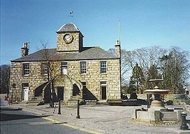
. Its Town House dates back to 1747. It is situated on the banks of the River Don
River Don, Aberdeenshire
The River Don is a river in north-east Scotland. It rises in the Grampians and flows eastwards, through Aberdeenshire, to the North Sea at Aberdeen. The Don passes through Alford, Kemnay, Inverurie, Kintore, and Dyce...
.
Kintore is said to be the fastest growing town in Aberdeenshire in percentage terms. The population in the 2001 census was 1696. By 2001 Aberdeenshire Council's figures gave the population as 2170, with a predicted 2521 in 2006.
NECR
NECRNECR
NECR is a broadcast radio station based in Kintore, Aberdeenshire, Scotland. NECR was awarded an Independent Local Radio Licence in 1993 and started broadcasting in 1994. The station is a totally independent radio station which is accountable to a small local board of directors...
(North East Community Radio) is a local radio
Radio
Radio is the transmission of signals through free space by modulation of electromagnetic waves with frequencies below those of visible light. Electromagnetic radiation travels by means of oscillating electromagnetic fields that pass through the air and the vacuum of space...
station based in School Road in Kintore (opposite the Torryburn Hotel).
Roman Camp
Kintore is the site of Deers DenDeers Den
Deers Den is an archaeological site at Kintore, Scotland in Aberdeenshire. The site has mesolithic remains, Iron Age artefacts and is a known Roman Camp. This site is partially disturbed and developed by the western part of Kintore itself. The site is associated with the Severan invasion, ca...
Roman Camp and is thought to relate to Agricola
Sextus Calpurnius Agricola
Sextus Calpurnius Agricola was a Roman general and politician of the 2nd century.Calpurnius Agricola was governor of Germania Superior around 158....
's campaigns into Scotland; moreover, Deers Den is associated with the invasion of Severan.Archaeologists say that the Kintore camp was definitely occupied in 120 AD and may have been occupied on as many as three occasions during the Scottish campaigns, before lack of resources and more pressing matters elsewhere in the Roman Empire
Roman Empire
The Roman Empire was the post-Republican period of the ancient Roman civilization, characterised by an autocratic form of government and large territorial holdings in Europe and around the Mediterranean....
induced consolidation and retreat.
The Romans, it is believed, were attracted by the belief that Scotland was rich in natural resources, including gold, silver and tin. The Deer's Den camp could have been involved in the preparations for the decisive battle of Mons Graupius
Battle of Mons Graupius
According to Tacitus, the Battle of Mons Graupius took place in AD 83 or, less probably, 84. Gnaeus Julius Agricola, the Roman governor and Tacitus' father-in-law, had sent his fleet ahead to panic the Caledonians, and, with light infantry reinforced with British auxiliaries, reached the site,...
; however, most researchers argue that the site of Mons Graupius was further south in Aberdeenshire, possibly near Raedykes
Raedykes
Raedykes is the site of a Roman marching camp located just over 3 miles NW of Stonehaven, Aberdeenshire, Scotland. National Grid Reference NO 842902...
at Kempstone Hill
Kempstone Hill
Kempstone Hill is a landform in Aberdeenshire, Scotland within the Mounth Range of the Grampian Mountains. The peak elevation of this mountain is 132 metres above mean sea level. This hill has been posited by Gabriel Jacques Surenne, Archibald Watt and C.Michael Hogan as the location for the...
or Megray Hill
Megray Hill
Megray Hill is a low lying coastal mountainous landform in Aberdeenshire, Scotland within the Mounth Range of the Grampian Mountains. The peak elevation of this mountain is 120 metres above mean sea level. This hill has been posited as a likely location for the noted Battle of Mons Graupius...
.
Arriving from the south Roman legion
Roman legion
A Roman legion normally indicates the basic ancient Roman army unit recruited specifically from Roman citizens. The organization of legions varied greatly over time but they were typically composed of perhaps 5,000 soldiers, divided into maniples and later into "cohorts"...
s marched from Raedykes
Raedykes
Raedykes is the site of a Roman marching camp located just over 3 miles NW of Stonehaven, Aberdeenshire, Scotland. National Grid Reference NO 842902...
to Normandykes
Normandykes
Normandykes is the site of a Roman marching camp to the southwest of Peterculter, Aberdeenshire, Scotland. The near-rectangular site, measuring approximately , covers about of the summit and eastern slopes of a hill overlooking the River Dee and the B9077 road further south. Aerial photographs...
Roman Camp through the Durris Forest
Durris Forest
Durris Forest is a chiefly coniferous forest south of the River Dee approximately three kilometres west of Netherley in Aberdeenshire, Scotland. The A957 road forms the southwest boundary of Durris Forest, separating it from Fetteresso Forest. The Durris Forest includes several smaller named...
as they sought higher ground evading the bog
Bog
A bog, quagmire or mire is a wetland that accumulates acidic peat, a deposit of dead plant material—often mosses or, in Arctic climates, lichens....
s of Red Moss and other low-lying mosses associated with the Burn of Muchalls
Burn of Muchalls
The Burn of Muchalls is an easterly flowing stream in Aberdeenshire, Scotland that discharges to the North Sea. Its point of discharge is on a rocky beach set with scenic sea stacks...
. That march used the Elsick Mounth
Elsick Mounth
The Elsick Mounth is an ancient trackway crossing the Grampian Mountains in the vicinity of Netherley, Scotland. This trackway was one of the few means of traversing the Grampian Mounth area in prehistoric and medieval times. The highest pass of the route is attained within the Durris Forest...
, one of the ancient trackway
Trackway
A trackway is an ancient route of travel for people or animals. In biology, a trackway can be a set of impressions in the soft earth, usually a set of footprints, left by an animal. A fossil trackway is the fossilized imprint of a trackway. Trackways have been found all over the world...
s crossing the Mounth
Mounth
The Mounth is the range of hills on the southern edge of Strathdee in northeast Scotland. It was usually referred to with the article, i.e. "the Mounth". The name is a corruption of the Scottish Gaelic monadh which in turn is akin to the Welsh mynydd, and may be of Pictish origin...
of the Grampian Mountains, lying west of Netherley.