
Cunninghame
Encyclopedia
Cunninghame is a former comital district of Scotland
and also a district of the Strathclyde
Region from 1975–1996.
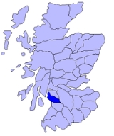
.png) The historic district of Cunninghame was bordered by the districts of Renfrew and Clydesdale
The historic district of Cunninghame was bordered by the districts of Renfrew and Clydesdale
to the north and east respectively, by the district of Kyle
to the south over the River Irvine and by the Firth of Clyde
to the west.
Cunninghame became one of the three districts or bailieries of Ayrshire
, the shire
or sheriffdom
of Ayr. Cunninghame was in the north, along the River Irvine
; Kyle was in the centre, along the River Ayr
; and Carrick was in the south, along the River Doon
. By the eighteenth century Ayrshire had become one of the counties of Scotland
, with the three baileries being described as "districts" or "divisions" of the county, although they had no formal administrative existence.
In the late nineteenth century the "territorial division" was described as comprising the civil parishes of Ardrossan
, Beith
, Dalry, Dreghorn
, Fenwick
, Irvine, North Ayrshire
, Kilbirnie
, West Kilbride
, Kilmarnock
, Kilmaurs
, Kilwinning
, Largs
, Loudoun
, Stevenston
, Stewarton
and part of Dunlop
.
The Cunninghame poor law
combination was formed in the 1850s with a poorhouse at Irvine. it had a different area from the ancient district.
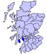
The name was revived for one of nineteen districts of the Strathclyde region of Scotland, formed by the Local Government (Scotland) Act 1973
in 1975. The district was formed from parts of the former counties
of Ayrshire and Bute
, namely:
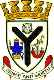
The Cunninghame District Council was granted a coat of arms
by Lord Lyon King of Arms
in 1979. The main feature of the arms was a black "shakefork" from the arms of the Cunningham family. To the left was the arms of the former royal burgh
of Irvine, based on the crest of the royal arms of Scotland, and said to have been granted to the town by King David I
. To the right was an ancient ship which had appeared in the arms of both Bute County Council and Arran District Council. Above the shakefork was a leopard's head holding in its mouth a weaver's shuttle. this represented the weaving industry of the inland parts of the district. Such an emblem appeared in Scottish arms grants to weaving societies and associations, and in the armorial bearings of the Worshipful Company of Weavers
of the City of London
. The motto was Sense and Worth, and the arms were completed by a gold coronet of a design reserved by Lord Lyon to district councils, topped by thistle-heads.
The district was abolished in 1996 by the Local Government etc. (Scotland) Act 1994
, when the system of regions and districts was replaced by unitary council areas. The area of the Cunninghame district (including Arran) became North Ayrshire
council area.
Scotland
Scotland is a country that is part of the United Kingdom. Occupying the northern third of the island of Great Britain, it shares a border with England to the south and is bounded by the North Sea to the east, the Atlantic Ocean to the north and west, and the North Channel and Irish Sea to the...
and also a district of the Strathclyde
Strathclyde
right|thumb|the former Strathclyde regionStrathclyde was one of nine former local government regions of Scotland created by the Local Government Act 1973 and abolished in 1996 by the Local Government etc Act 1994...
Region from 1975–1996.
Historic Cunninghame
Clydesdale
Clydesdale was formerly one of nineteen local government districts in the Strathclyde region of Scotland.The district was formed by the Local Government Act 1973 from part of the former county of Lanarkshire: namely the burghs of Biggar and Lanark and the First, Second and Third Districts...
to the north and east respectively, by the district of Kyle
Kyle, Ayrshire
Kyle is a former comital district of Scotland which stretched across parts of modern day East Ayrshire and South Ayrshire...
to the south over the River Irvine and by the Firth of Clyde
Firth of Clyde
The Firth of Clyde forms a large area of coastal water, sheltered from the Atlantic Ocean by the Kintyre peninsula which encloses the outer firth in Argyll and Ayrshire, Scotland. The Kilbrannan Sound is a large arm of the Firth of Clyde, separating the Kintyre Peninsula from the Isle of Arran.At...
to the west.
Cunninghame became one of the three districts or bailieries of Ayrshire
Ayrshire
Ayrshire is a registration county, and former administrative county in south-west Scotland, United Kingdom, located on the shores of the Firth of Clyde. Its principal towns include Ayr, Kilmarnock and Irvine. The town of Troon on the coast has hosted the British Open Golf Championship twice in the...
, the shire
Shire
A shire is a traditional term for a division of land, found in the United Kingdom and in Australia. In parts of Australia, a shire is an administrative unit, but it is not synonymous with "county" there, which is a land registration unit. Individually, or as a suffix in Scotland and in the far...
or sheriffdom
Sheriffdom
A sheriffdom is a judicial district in Scotland.Since 1 January 1975 there have been six sheriffdoms. Previously sheriffdoms were composed of groupings of counties...
of Ayr. Cunninghame was in the north, along the River Irvine
River Irvine
The River Irvine is a river flowing through southwest Scotland, with its watershed on the Lanarkshire border of Ayrshire at an altitude of above sea-level, near Drumclog, and SW by W of Strathaven...
; Kyle was in the centre, along the River Ayr
River Ayr
The River Ayr , longest river in what was the old county of Ayrshire of Scotland, is approximately 65 kilometres in length. It originates at Glenbuck Loch in East Ayrshire on the border of Lanarkshire and winds its way through East and South Ayrshire to the town of Ayr, where it empties into the...
; and Carrick was in the south, along the River Doon
River Doon
The River Doon is a river in South Ayrshire, Scotland. The river flows 23 miles from Loch Doon, joining the Firth of Clyde just south of Ayr. Its course is generally north-westerly, passing near to the town of Dalmellington, and through the villages of Patna, Dalrymple, and Alloway, birthplace...
. By the eighteenth century Ayrshire had become one of the counties of Scotland
Counties of Scotland
The counties of Scotland were the principal local government divisions of Scotland until 1975. Scotland's current lieutenancy areas and registration counties are largely based on them. They are often referred to as historic counties....
, with the three baileries being described as "districts" or "divisions" of the county, although they had no formal administrative existence.
In the late nineteenth century the "territorial division" was described as comprising the civil parishes of Ardrossan
Ardrossan
Ardrossan is a town on the North Ayrshire coast in south-western Scotland. The name "Ardrossan" describes its physical position — 'ard' from the Gaelic àird meaning headland, 'ros' a promontory and the diminutive suffix '-an' - headland of the little promontory...
, Beith
Beith
Beith is a small town situated in the Garnock Valley in North Ayrshire, Scotland approximately 20-miles south-west of Glasgow. The town is situated on the crest of a hill and was known originally as the "Hill o' Beith" after its Court Hill.-History:-Name:Beith's name is thought to emanate from...
, Dalry, Dreghorn
Dreghorn
Dreghorn is a village near Irvine, North Ayrshire, Scotland. This parish comprehends the old parishes of Dreghorn and Pearston, which were united in 1668. The whole of the parish was historically the property of the De Morvilles, who were Constables of Scotland and Lords of Cunninghame...
, Fenwick
Fenwick, East Ayrshire
Fenwick is a village in East Ayrshire, Scotland, UK. As of 2001, its population was 863.Fenwick is the terminus of the M77 following its extension which was opened in April 2005, at the beginning of the Kilmarnock bypass....
, Irvine, North Ayrshire
Irvine, North Ayrshire
Irvine is a new town on the coast of the Firth of Clyde in North Ayrshire, Scotland. According to 2007 population estimates, the town is home to 39,527 inhabitants, making it the biggest settlement in North Ayrshire....
, Kilbirnie
Kilbirnie
Kilbirnie is a small town of 7280 inhabitants situated in North Ayrshire on the west coast of Scotland...
, West Kilbride
West Kilbride
West Kilbride is a village in North Ayrshire, on the west coast of Scotland by the Firth of Clyde, looking across the water to Goat Fell and the Isle of Arran...
, Kilmarnock
Kilmarnock
Kilmarnock is a large burgh in East Ayrshire, Scotland, with a population of 44,734. It is the second largest town in Ayrshire. The River Irvine runs through its eastern section, and the Kilmarnock Water passes through it, giving rise to the name 'Bank Street'...
, Kilmaurs
Kilmaurs
Kilmaurs is a village in East Ayrshire, Scotland. It lies on the Carmel, 21.1 miles south by west of Glasgow. Population recorded in 2001 Census, 2601- History :...
, Kilwinning
Kilwinning
Kilwinning is a historic town in North Ayrshire, Scotland. It is known as The Crossroads of Ayrshire. The 2001 Census recorded it as having a population of 15,908.-History:...
, Largs
Largs
Largs is a town on the Firth of Clyde in North Ayrshire, Scotland, about from Glasgow. The original name means "the slopes" in Scottish Gaelic....
, Loudoun
Loudoun
Loudoun is an area of East Ayrshire, Scotland, east of Kilmarnock. The word Loudoun is a derivative of the Celtic Pagan God name Lugus.Loudoun is a parish and is named after the former village which stood north of Galston. The area is commonly referred to as the "Irvine Valley", for the River...
, Stevenston
Stevenston
Stevenston is a town in North Ayrshire, Scotland. It is one of the 'Three Towns' along with Ardrossan and Saltcoats.-History:The town is named after Stephan Loccard or Lockhart, whose father obtained a grant of land from Richard de Morville, Lord Cunninghame and Constable of Scotland, around 1170....
, Stewarton
Stewarton
Stewarton is a town in East Ayrshire, Scotland. In comparison to the neighbouring towns of Kilmaurs, Fenwick, Dunlop and Lugton, it is a relatively large town, with a population of over 6,500. It is 300 feet above sea level.Groome, Francis H. . Ordnance Gazetteer of Scotland. Pub. Caxton. London....
and part of Dunlop
Dunlop, East Ayrshire
Dunlop is a village and parish in East Ayrshire, Scotland. It lies on the A735, north-east of Stewarton, seven miles from Kilmarnock. The road runs on to Lugton and the B706 enters the village from Beith.-The village:...
.
The Cunninghame poor law
Poor Law
The English Poor Laws were a system of poor relief which existed in England and Wales that developed out of late-medieval and Tudor-era laws before being codified in 1587–98...
combination was formed in the 1850s with a poorhouse at Irvine. it had a different area from the ancient district.
Local government district
| Cunninghame 1975 to 1996 | |
 |
Local Government (Scotland) Act 1973
The Local Government Act 1973 is an Act of the Parliament of the United Kingdom, that reformed local government in Scotland, on May 16, 1975....
in 1975. The district was formed from parts of the former counties
Counties of Scotland
The counties of Scotland were the principal local government divisions of Scotland until 1975. Scotland's current lieutenancy areas and registration counties are largely based on them. They are often referred to as historic counties....
of Ayrshire and Bute
County of Bute
The County of Bute is one of the registration counties of Scotland. In 2001 its usually resident population was 13,720.-Local government county:...
, namely:
- From Ayrshire:
- The burghBurghA burgh was an autonomous corporate entity in Scotland and Northern England, usually a town. This type of administrative division existed from the 12th century, when King David I created the first royal burghs. Burgh status was broadly analogous to borough status, found in the rest of the United...
s of ArdrossanArdrossanArdrossan is a town on the North Ayrshire coast in south-western Scotland. The name "Ardrossan" describes its physical position — 'ard' from the Gaelic àird meaning headland, 'ros' a promontory and the diminutive suffix '-an' - headland of the little promontory...
, IrvineIrvine, North AyrshireIrvine is a new town on the coast of the Firth of Clyde in North Ayrshire, Scotland. According to 2007 population estimates, the town is home to 39,527 inhabitants, making it the biggest settlement in North Ayrshire....
, KilwinningKilwinningKilwinning is a historic town in North Ayrshire, Scotland. It is known as The Crossroads of Ayrshire. The 2001 Census recorded it as having a population of 15,908.-History:...
, LargsLargsLargs is a town on the Firth of Clyde in North Ayrshire, Scotland, about from Glasgow. The original name means "the slopes" in Scottish Gaelic....
, SaltcoatsSaltcoats- References :*McSherry, R. & M. . Old Saltcoats, Stenlake Publishing, Ochiltree. ISBN 1-872074-57-X.*Stansfield, G. . Ayrshire & Renfrewshire's Lost Railways, Stenlake Publishing, Catrine. ISBN 1-84033-077-5.-External links:***...
and StevenstonStevenstonStevenston is a town in North Ayrshire, Scotland. It is one of the 'Three Towns' along with Ardrossan and Saltcoats.-History:The town is named after Stephan Loccard or Lockhart, whose father obtained a grant of land from Richard de Morville, Lord Cunninghame and Constable of Scotland, around 1170.... - The districts of Irvine, KilbirnieKilbirnieKilbirnie is a small town of 7280 inhabitants situated in North Ayrshire on the west coast of Scotland...
and West KilbrideWest KilbrideWest Kilbride is a village in North Ayrshire, on the west coast of Scotland by the Firth of Clyde, looking across the water to Goat Fell and the Isle of Arran... - The parts of the districts of Ayr and Kilmarnock in the designated area of Irvine New TownNew towns in the United KingdomBelow is a list of some of the new towns in the United Kingdom created under the various New Town Acts of the 20th century. Some earlier towns were developed as Garden Cities or overspill estates early in the twentieth century. The New Towns proper were planned to disperse population following the...
- The burgh
- From Bute:
- The burgh of MillportMillport, Isle of CumbraeMillport is the only town on the island of Great Cumbrae in the Firth of Clyde off the coast of North Ayrshire, Scotland. The town is four miles south from the Largs-based Caledonian MacBrayne ferry slipway....
- The districts of ArranIsle of ArranArran or the Isle of Arran is the largest island in the Firth of Clyde, Scotland, and with an area of is the seventh largest Scottish island. It is in the unitary council area of North Ayrshire and the 2001 census had a resident population of 5,058...
and Cumbrae
- The burgh of Millport
The Cunninghame District Council was granted a coat of arms
Coat of arms
A coat of arms is a unique heraldic design on a shield or escutcheon or on a surcoat or tabard used to cover and protect armour and to identify the wearer. Thus the term is often stated as "coat-armour", because it was anciently displayed on the front of a coat of cloth...
by Lord Lyon King of Arms
Lord Lyon King of Arms
The Lord Lyon King of Arms, the head of Lyon Court, is the most junior of the Great Officers of State in Scotland and is the Scottish official with responsibility for regulating heraldry in that country, issuing new grants of arms, and serving as the judge of the Court of the Lord Lyon, the oldest...
in 1979. The main feature of the arms was a black "shakefork" from the arms of the Cunningham family. To the left was the arms of the former royal burgh
Royal burgh
A royal burgh was a type of Scottish burgh which had been founded by, or subsequently granted, a royal charter. Although abolished in 1975, the term is still used in many of the former burghs....
of Irvine, based on the crest of the royal arms of Scotland, and said to have been granted to the town by King David I
David I of Scotland
David I or Dabíd mac Maíl Choluim was a 12th-century ruler who was Prince of the Cumbrians and later King of the Scots...
. To the right was an ancient ship which had appeared in the arms of both Bute County Council and Arran District Council. Above the shakefork was a leopard's head holding in its mouth a weaver's shuttle. this represented the weaving industry of the inland parts of the district. Such an emblem appeared in Scottish arms grants to weaving societies and associations, and in the armorial bearings of the Worshipful Company of Weavers
Worshipful Company of Weavers
The Worshipful Company of Weavers is the most ancient of the Livery Companies in the City of London. It existed in the year 1130, and was perhaps formed earlier. The Company received a Royal Charter in 1180. At present, the Company retains a connection to textiles through its contributions to the...
of the City of London
City of London
The City of London is a small area within Greater London, England. It is the historic core of London around which the modern conurbation grew and has held city status since time immemorial. The City’s boundaries have remained almost unchanged since the Middle Ages, and it is now only a tiny part of...
. The motto was Sense and Worth, and the arms were completed by a gold coronet of a design reserved by Lord Lyon to district councils, topped by thistle-heads.
The district was abolished in 1996 by the Local Government etc. (Scotland) Act 1994
Local Government etc. (Scotland) Act 1994
The Local Government etc. Act 1994 is an Act of the Parliament of the United Kingdom which created the current local government structure of 32 unitary authorities covering the whole of Scotland....
, when the system of regions and districts was replaced by unitary council areas. The area of the Cunninghame district (including Arran) became North Ayrshire
North Ayrshire
North Ayrshire is one of 32 council areas in Scotland with a population of roughly 136,000 people. It is located in the south-west region of Scotland, and borders the areas of Inverclyde to the north, Renfrewshire to the north-east and East Ayrshire and South Ayrshire to the East and South...
council area.