
Clackmannanshire
Encyclopedia
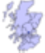
Clackmannanshire, often abbreviated to Clacks ( and from the meaning 'Stone of Manau') is a local government council area in Scotland
, and a lieutenancy area
, bordering Perth and Kinross
, Stirling
and Fife
.
As Scotland's smallest historic county, it is often nicknamed 'The Wee County'.
Between 1889 and 1975, the County of Clackmannan was a local government county
, bordering on Perthshire
, Stirlingshire
and Fife
.
The council area was recreated in 1996, under the Local Government etc (Scotland) Act 1994, with the boundaries of the former Clackmannan district of the Central
region
. Prior to the Central District being created in 1975 the area had historically been called Clackmannanshire and there was strong pressure to resurrect this title rather than hold to the rather bland title of "Central Region". Central Region had been created in 1975, under the Local Government (Scotland) Act 1973
, to include the county
of Clackmannan plus the Muckhart
and Glendevon areas, formerly in the county of Perth. Technically these two areas had been transferred to Clackmannanshire in 1971 under a reorganisation of boundaries.
According to the legislation of 1996, the council area was to have the name, Clackmannan, of the former district, but this was changed to Clackmannanshire, by the council using its own powers.
In terms of population, it is the smallest council area in mainland Scotland, with a population of 48,630 (in 2005), around half of whom live in the main town, Alloa
, which is the administrative centre, having outgrown the town of Clackmannan
in 1822.
The motto of Clackmannanshire is "Look Aboot Ye" (Circumspice in Latin
). In 2007 a re-branding exercise led to the area adopting the slogan "More Than You Imagine".
lie in the Strathdevon
or northern part of the area. Strathdevon
mostly comprises a lowland plain
a few hundred meters either side of the River Devon
, and this goes on to contribute to the formation the valley of the River Forth
and joins the Forth near Cambus
. There is also the Black Devon
river that flows past the town of Clackmannan
to join the River Forth near Alloa. This confluence once had a small pier for portage
to Dunmore pier and anchor
age of smaller sailing ships, where others of more tonnage could be accepted at Dunmore pier on the opposite banks of the forth.
, brewing
, and formerly coal mining
. In 2006, permission was given for a waterfront development of the Docks area of Alloa, which has been in decline since the 1960s.
Alloa railway station
reopened in May 2008. A new railway line
connecting Kincardine and Stirling, reconnecting Alloa to the national rail network for the first time since 1968 was opened to the public. Passenger services only operate towards Stirling, the line to Kincardine is for freight trains only. An opening ceremony was held on Thursday 15 May, with the first fully functioning passenger service commencing in the new summer timetable on 19 May 2008. The service provides an hourly connection between Alloa, Stirling and Glasgow Queen Street.
The stone now rests on a larger stone beside the Tollbooth and Mercat Cross at the top of Main street, Clackmannan.
Legend has it that Robert the Bruce mislaid his glove while in the area and, on asking where it was, was told "Look aboot ye". The county's coat of arms shows a pair of gloves.
Clackmannanshire became known for the weaving mills powered by the Hillfoots burns. Other industries included brewing, glass manufacture, mining and ship building.
Now capitalising on its central position and transport links, Clackmannanshire attracts service industries and tourism.
Scotland
Scotland is a country that is part of the United Kingdom. Occupying the northern third of the island of Great Britain, it shares a border with England to the south and is bounded by the North Sea to the east, the Atlantic Ocean to the north and west, and the North Channel and Irish Sea to the...
, and a lieutenancy area
Lieutenancy areas of Scotland
The lieutenancy areas of Scotland are the areas used for the ceremonial lord-lieutenants, the monarch's representatives, in Scotland. They are different from the local government council areas, the committee areas, the sheriffdoms, the registration counties, the former regions and districts, the...
, bordering Perth and Kinross
Perth and Kinross
Perth and Kinross is one of 32 council areas in Scotland, and a Lieutenancy Area. It borders onto the Aberdeenshire, Angus, Dundee City, Fife, Clackmannanshire, Stirling, Argyll and Bute and Highland council areas. Perth is the administrative centre...
, Stirling
Stirling (council area)
Stirling is one of the 32 unitary local government council areas of Scotland, and has a population of about 87,000 . It was created under the Local Government etc Act 1994 with the boundaries of the Stirling district of the former Central local government region, and it covers most of the former...
and Fife
Fife
Fife is a council area and former county of Scotland. It is situated between the Firth of Tay and the Firth of Forth, with inland boundaries to Perth and Kinross and Clackmannanshire...
.
As Scotland's smallest historic county, it is often nicknamed 'The Wee County'.
Between 1889 and 1975, the County of Clackmannan was a local government county
Counties of Scotland
The counties of Scotland were the principal local government divisions of Scotland until 1975. Scotland's current lieutenancy areas and registration counties are largely based on them. They are often referred to as historic counties....
, bordering on Perthshire
Perthshire
Perthshire, officially the County of Perth , is a registration county in central Scotland. It extends from Strathmore in the east, to the Pass of Drumochter in the north, Rannoch Moor and Ben Lui in the west, and Aberfoyle in the south...
, Stirlingshire
Stirlingshire
Stirlingshire or the County of Stirling is a registration county of Scotland, based around Stirling, the former county town. It borders Perthshire to the north, Clackmannanshire and West Lothian to the east, Lanarkshire to the south, and Dunbartonshire to the south-west.Until 1975 it was a county...
and Fife
Fife
Fife is a council area and former county of Scotland. It is situated between the Firth of Tay and the Firth of Forth, with inland boundaries to Perth and Kinross and Clackmannanshire...
.
The council area was recreated in 1996, under the Local Government etc (Scotland) Act 1994, with the boundaries of the former Clackmannan district of the Central
Central Region, Scotland
Central Region was a local government region of Scotland from 1975 to 1996. It is now divided into the council areas of Falkirk, Stirling, and Clackmannanshire, which had previously been districts within Central...
region
Regions and districts of Scotland
The local government areas of Scotland were redefined by the Local Government Act 1973 and redefined again by the Local Government etc Act 1994....
. Prior to the Central District being created in 1975 the area had historically been called Clackmannanshire and there was strong pressure to resurrect this title rather than hold to the rather bland title of "Central Region". Central Region had been created in 1975, under the Local Government (Scotland) Act 1973
Local Government (Scotland) Act 1973
The Local Government Act 1973 is an Act of the Parliament of the United Kingdom, that reformed local government in Scotland, on May 16, 1975....
, to include the county
Counties of Scotland
The counties of Scotland were the principal local government divisions of Scotland until 1975. Scotland's current lieutenancy areas and registration counties are largely based on them. They are often referred to as historic counties....
of Clackmannan plus the Muckhart
Muckhart
Muckhart commonly refers to two small villages in Clackmannanshire, Scotland, Pool of Muckhart and Yetts o' Muckhart. Muckhart is one of the Hillfoots Villages, situated on the A91 around 3 miles north-east of Dollar...
and Glendevon areas, formerly in the county of Perth. Technically these two areas had been transferred to Clackmannanshire in 1971 under a reorganisation of boundaries.
According to the legislation of 1996, the council area was to have the name, Clackmannan, of the former district, but this was changed to Clackmannanshire, by the council using its own powers.
In terms of population, it is the smallest council area in mainland Scotland, with a population of 48,630 (in 2005), around half of whom live in the main town, Alloa
Alloa
Alloa is a town and former burgh in Clackmannanshire, set in the Central Lowlands of Scotland. It lies on on the north bank of the Firth of Forth close to the foot of the Ochil Hills, east of Stirling and north of Falkirk....
, which is the administrative centre, having outgrown the town of Clackmannan
Clackmannan, Clackmannanshire
Clackmannan , is a small town set in the Central Lowlands of Scotland. Situated within the Forth Valley, Clackmannan is south-east of Alloa and south of Tillicoultry...
in 1822.
The motto of Clackmannanshire is "Look Aboot Ye" (Circumspice in Latin
Latin
Latin is an Italic language originally spoken in Latium and Ancient Rome. It, along with most European languages, is a descendant of the ancient Proto-Indo-European language. Although it is considered a dead language, a number of scholars and members of the Christian clergy speak it fluently, and...
). In 2007 a re-branding exercise led to the area adopting the slogan "More Than You Imagine".
Council political composition
| Party | Councillors | |
| Labour | 8 | |
| Scottish National Party | 7 | |
| Conservative | 1 | |
| Liberal Democrat | 1 | |
| Independent | 1 |
Geography
The Ochil HillsOchil Hills
The Ochil Hills is a range of hills in Scotland north of the Forth valley bordered by the towns of Stirling, Alloa, Kinross and Perth. The only major roads crossing the hills pass through Glen Devon/Glen Eagles and Glenfarg, the latter now largely replaced except for local traffic by the M90...
lie in the Strathdevon
Strathdevon
Strathdevon is the strath of the River Devon in Clackmannanshire, Scotland. Strathdevon is associated with the parish of Muckhart and was up until 1971 the southernmost tip of Perthshire....
or northern part of the area. Strathdevon
Strathdevon
Strathdevon is the strath of the River Devon in Clackmannanshire, Scotland. Strathdevon is associated with the parish of Muckhart and was up until 1971 the southernmost tip of Perthshire....
mostly comprises a lowland plain
Plain
In geography, a plain is land with relatively low relief, that is flat or gently rolling. Prairies and steppes are types of plains, and the archetype for a plain is often thought of as a grassland, but plains in their natural state may also be covered in shrublands, woodland and forest, or...
a few hundred meters either side of the River Devon
River Devon
River Devon may refer to:*River Devon, Clackmannanshire, Scotland*River Devon, Nottinghamshire, England...
, and this goes on to contribute to the formation the valley of the River Forth
River Forth
The River Forth , long, is the major river draining the eastern part of the central belt of Scotland.The Forth rises in Loch Ard in the Trossachs, a mountainous area some west of Stirling...
and joins the Forth near Cambus
Cambus (disambiguation)
-In transport:*Cambus, a public transport service for the University of Iowa*Stagecoach in Cambridge, a public transport company in Cambridge, England which is part of the Stagecoach Group and is the trading name for Cambus Ltd.-In placenames:...
. There is also the Black Devon
Black Devon
The Black Devon is a river in Scotland. It rises in the area west of Knockhill Racing Circuit, around north-west of Dunfermline, Fife, with the gathering of three small streams in branch formation. The river flows westwards through Balgonar, north of Saline, and then merges with the Saline Burn...
river that flows past the town of Clackmannan
Clackmannan
Clackmannan District 1975-96From 1975, Clackmannan was the name of a small town and local government district in the Central region of Scotland, corresponding to the traditional county of Clackmannanshire, which was Scotland's smallest...
to join the River Forth near Alloa. This confluence once had a small pier for portage
Portage
Portage or portaging refers to the practice of carrying watercraft or cargo over land to avoid river obstacles, or between two bodies of water. A place where this carrying occurs is also called a portage; a person doing the carrying is called a porter.The English word portage is derived from the...
to Dunmore pier and anchor
Anchor
An anchor is a device, normally made of metal, that is used to connect a vessel to the bed of a body of water to prevent the vessel from drifting due to wind or current. The word derives from Latin ancora, which itself comes from the Greek ἄγκυρα .Anchors can either be temporary or permanent...
age of smaller sailing ships, where others of more tonnage could be accepted at Dunmore pier on the opposite banks of the forth.
Economy
The main industries are agricultureAgriculture
Agriculture is the cultivation of animals, plants, fungi and other life forms for food, fiber, and other products used to sustain life. Agriculture was the key implement in the rise of sedentary human civilization, whereby farming of domesticated species created food surpluses that nurtured the...
, brewing
Brewing
Brewing is the production of beer through steeping a starch source in water and then fermenting with yeast. Brewing has taken place since around the 6th millennium BCE, and archeological evidence suggests that this technique was used in ancient Egypt...
, and formerly coal mining
Coal mining
The goal of coal mining is to obtain coal from the ground. Coal is valued for its energy content, and since the 1880s has been widely used to generate electricity. Steel and cement industries use coal as a fuel for extraction of iron from iron ore and for cement production. In the United States,...
. In 2006, permission was given for a waterfront development of the Docks area of Alloa, which has been in decline since the 1960s.
Alloa railway station
Alloa railway station
Alloa railway station is a railway station in the town of Alloa, Clackmannanshire, Scotland, which was re-opened on Monday, 19 May 2008.- History :...
reopened in May 2008. A new railway line
Stirling-Alloa-Kincardine rail link
The Stirling-Alloa-Kincardine rail link was a project to re-open of railway line between the towns of Stirling, Alloa and Kincardine in Scotland, United Kingdom. The route opened to rail traffic in March 2008.- Background :...
connecting Kincardine and Stirling, reconnecting Alloa to the national rail network for the first time since 1968 was opened to the public. Passenger services only operate towards Stirling, the line to Kincardine is for freight trains only. An opening ceremony was held on Thursday 15 May, with the first fully functioning passenger service commencing in the new summer timetable on 19 May 2008. The service provides an hourly connection between Alloa, Stirling and Glasgow Queen Street.
History
Clackmannan, the old county town, is named after the ancient stone associated with the pre-Christian deity Manau or Mannan.The stone now rests on a larger stone beside the Tollbooth and Mercat Cross at the top of Main street, Clackmannan.
Legend has it that Robert the Bruce mislaid his glove while in the area and, on asking where it was, was told "Look aboot ye". The county's coat of arms shows a pair of gloves.
Clackmannanshire became known for the weaving mills powered by the Hillfoots burns. Other industries included brewing, glass manufacture, mining and ship building.
Now capitalising on its central position and transport links, Clackmannanshire attracts service industries and tourism.
Towns and villages
- AlloaAlloaAlloa is a town and former burgh in Clackmannanshire, set in the Central Lowlands of Scotland. It lies on on the north bank of the Firth of Forth close to the foot of the Ochil Hills, east of Stirling and north of Falkirk....
- administrative centre - AlvaAlva, ClackmannanshireAlva is a small town in Clackmannanshire, set in the Central Lowlands of Scotland. It is one of a number of towns situated immediately to the south of the Ochil Hills, collectively referred to as the Hillfoots Villages or simply The Hillfoots...
- Cambus
- ClackmannanClackmannan, ClackmannanshireClackmannan , is a small town set in the Central Lowlands of Scotland. Situated within the Forth Valley, Clackmannan is south-east of Alloa and south of Tillicoultry...
- CoalsnaughtonCoalsnaughtonCoalsnaughton or Calibar is a village in Clackmannanshire, Scotland. It is just south of Tillicoultry....
- Devonside
- DollarDollar, ClackmannanshireDollar is a small town in Clackmannanshire, Scotland. It is one of the Hillfoots Villages, situated between the Ochil Hills range to the north and the River Devon to the south. Dollar is on the A91 road, which runs from Stirling to St. Andrews. The town is around 3 miles east of Tillicoultry...
- FishcrossFishcrossFishcross is a small village in Clackmannanshire in central Scotland, situated to the north of Sauchie at a crossroads just south of Tillicoultry. Formerly a mining village, the population is 484 as at 2003...
- Forestmill
- Glenochil
- Inglewood
- KennetKennet, ClackmannanshireKennet is a small former coal mining village in Clackmannanshire, Scotland. It is located south-east of Clackmannan, by the Kincardine railway line. The village is a conservation area, designated by Clackmannanshire Council....
- MenstrieMenstrieMenstrie is a village in the county of Clackmannanshire in Scotland, UK. It is about 5 miles east-north-east of Stirling...
- MuckhartMuckhartMuckhart commonly refers to two small villages in Clackmannanshire, Scotland, Pool of Muckhart and Yetts o' Muckhart. Muckhart is one of the Hillfoots Villages, situated on the A91 around 3 miles north-east of Dollar...
- SauchieSauchieSauchie is a village in the Central Lowlands of Scotland. It lies north of the River Forth and south of the Ochil Hills, within the council area of Clackmannanshire. Sauchie is located north-east of Alloa and east-southeast of Tullibody.- History :...
- Solsgirth
- TillicoultryTillicoultryTillicoultry...
- TullibodyTullibodyTullibody is a town set in the Central Lowlands of Scotland. It lies north of the River Forth near to the foot of the Ochil Hills within the Forth Valley. The town is south-west of Alva, north-west of Alloa and east-northeast of Stirling...
Places of interest
- Alloa TowerAlloa TowerAlloa Tower in Alloa in central Scotland is the surviving part of the medieval residence of the Clan Erskine family, the Earls of Mar.An architect which was involved in the Alloa Tower was John Melvin....
- Ben CleuchBen CleuchBen Cleuch is a mountain in Scotland.It is the highest point in the Ochil Hills, and the highest point in Clackmannanshire. It is high....
- Castle CampbellCastle CampbellCastle Campbell is a mediæval castle situated above the town of Dollar, Clackmannanshire in central Scotland. It was the seat of the Earls and Dukes of Argyll, chiefs of Clan Campbell.- History :...
- Gartmorn Dam
- Menstrie CastleMenstrie CastleMenstrie Castle is a three-storey castellated house in the town of Menstrie, Clackmannanshire, near Stirling, central Scotland. From the early 17th century, it was home to Sir William Alexander, 1st Earl of Stirling, who was instrumental in founding the colony of Nova Scotia. It was later owned by...
External links
- Clacksweb - Clackmannanshire Council Online
- ClacksNet - Clackmannanshire's Community Network
- Census 2001 Information (PDF)
- National Library of Scotland - Clackmannanshire Map ca. 1681
- Look Aboot Ye - Clackmannanshire Community News, Information and Forums
- ASH Consulting Group 1998. Clackmannanshire landscape character assessment. Scottish Natural Heritage Review No 96.