

List of Appalachian Regional Commission counties
Encyclopedia
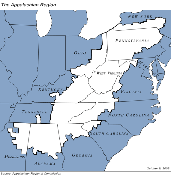
Appalachia
Appalachia is a term used to describe a cultural region in the eastern United States that stretches from the Southern Tier of New York state to northern Alabama, Mississippi, and Georgia. While the Appalachian Mountains stretch from Belle Isle in Canada to Cheaha Mountain in the U.S...
as defined by the Appalachian Regional Commission
Appalachian Regional Commission
The Appalachian Regional Commission is a United States federal-state partnership that works with the people of Appalachia to create opportunities for self-sustaining economic development and improved quality of life...
. The ARC was established by the United States federal government in 1965 to alleviate poverty in the Appalachian region, and currently monitors areas in 13 states.
The list shows the population of each county as of the 2000 U.S. Census; cities in Virginia, which are legally independent of counties, are included within the county with which they were historically associated. It also gives the following four variables:
- 3-year average unemployment rate, based on data collected 2006-2008
- Per capita market income, as of 2007
- Poverty rate, showing what percentage of the county lives below the national poverty rate, as of 2000
- Status, the ARC's economic status designation for the county, based on the three variables above. There are five possible designations:
- Distressed — these counties have at least twice the national poverty rate and have a per capita market income 67% of the national average or a three-year average unemployment rate that is twice the national average.
- At-Risk — these counties meet two of the following three criteria: 1) 3-year unemployment rate 125% of the national average, 2) per capita market income 67% or less of national average, or 3) poverty rate of 125% or more of the national average
- Transitional — these counties are worse than the national average on at least one of the three indicators, but do not meet criteria for "At-Risk" or "Distressed"
- Competitive — these counties have a three-year unemployment rate and poverty rate at least equal to the national average, and a per capita market income at least 80% of the national average
- Attainment — these counties are at least equal to the national average on all three indicators
The national 3-year average unemployment rate for the United States was 5.0% in the period 2006-2008. The national per capita market income was $32,930 in 2007. The national poverty rate was 12.4% in 2000. The 3-year average unemployment rate for the Appalachian region in 2006-2008 was 5.2%. The region's per capita market income in 2007 was $24,360. The region's poverty rate was 13.6%.
Alabama's Appalachian counties led all states' Appalachian counties in unemployment (3.8%) and per capita market income ($27,723). Georgia's Appalachian counties had the lowest average poverty rate (9.2%). Mississippi's Appalachian counties had the highest average unemployment rate at 7.9%, while Kentucky's Appalachian counties had the lowest average per capita market income ($15,690) and the highest average poverty rate (24.4%).
AlabamaAlabamaAlabama is a state located in the southeastern region of the United States. It is bordered by Tennessee to the north, Georgia to the east, Florida and the Gulf of Mexico to the south, and Mississippi to the west. Alabama ranks 30th in total land area and ranks second in the size of its inland...
| County | Population | Unemployment Rate | Market Income Per Capita |
Poverty Rate | Status |
|---|---|---|---|---|---|
| Bibb Bibb County, Alabama Bibb County is a county in the U.S. state of Alabama. Its name is in honor of William W. Bibb, the first Governor of Alabama. As of 2010 the population was 22,915. The county seat is Centreville... |
21,482 | 4.1% | $16,886 | 20.6% | At-Risk |
| Blount Blount County, Alabama Blount County is a county located in the U.S. state of Alabama. As of the 2010 United States Census, the population was 57,322. Its county seat is Oneonta.Blount County is a dry county.-History:... |
56,436 | 3.2% | $19,354 | 11.7% | Transitional |
| Calhoun Calhoun County, Alabama Calhoun County is a county in the U.S. state of Alabama. Its name is in honor of John C. Calhoun, famous member of the United States Senate from South Carolina. As of 2010 the population was 118,572. It is included in the Anniston-Oxford Metropolitan Statistical Area... |
112,903 | 4.0% | $24,157 | 16.1% | Transitional |
| Chambers Chambers County, Alabama Chambers County is a county of the U.S. state of Alabama. Its name is in honor of Henry H. Chambers, who served as a United States Senator from Alabama. As of 2010 the population was 34,215. Its county seat is Lafayette... |
35,176 | 7.9% | $18,062 | 17.0% | At-Risk |
| Cherokee Cherokee County, Alabama Cherokee County, Alabama is a county of the U.S. state of Alabama. It is named for the Cherokee tribe. As of 2010 the population was 25,989. Its county seat is Centre and it is a prohibition or dry county.- History :... |
24,863 | 4.2% | $18,348 | 15.6% | Transitional |
| Chilton Chilton County, Alabama -2010:Whereas according to the 2010 U.S. Census Bureau:*84.1% White*9.7% Black*0.4% Native American*0.3% Asian*0.0% Native Hawaiian or Pacific Islander*1.2% Two or more races*7.8% Hispanic or Latino -2000:... |
41,953 | 3.5% | $20,677 | 15.7% | Transitional |
| Clay Clay County, Alabama Clay County is a county of the US state of Alabama. Its name is in honor of Henry Clay, famous American statesman, member of the United States Senate from Kentucky and United States Secretary of State in the 19th century. As of 2010 the population was 13,932... |
13,829 | 5.3% | $18,756 | 17.1% | Transitional |
| Cleburne Cleburne County, Alabama Cleburne County is a county of the U.S. state of Alabama. Its name is in honor of Major General Patrick Cleburne, of Arkansas. As of 2010 the population was 14,972. Its county seat is Heflin.- History :... |
14,700 | 3.6% | $20,854 | 13.9% | Transitional |
| Colbert Colbert County, Alabama Colbert County is a county of the U.S. state of Alabama. Its name is in honor of brothers George and Levi Colbert, Chickasaw Indian chiefs. George Colbert operated a ferry across the Tennessee River in 1790 near present day Cherokee.... |
54,766 | 4.6% | $20,281 | 14.0% | Transitional |
| Coosa Coosa County, Alabama Coosa County is a county of the U.S. state of Alabama. Its name derives from a town of the Creek tribe. As of 2010 the population was 11,539, but since that time it has lost the most population by percentage of any Alabama county... |
11,044 | 5.8% | $16,394 | 14.9% | At-Risk |
| Cullman Cullman County, Alabama Cullman County is a county of the U.S. state of Alabama. Its name is in honor of Colonel John G. Cullmann. As of 2010, the population was 80,406. Its county seat is the town of the same name, Cullman, Alabama. It is a "moist" county in terms of availablity of alcoholic beverages, which means... |
80,187 | 3.4% | $21,038 | 13.0% | Transitional |
| DeKalb DeKalb County, Alabama As of the 2010 Census DeKalb County had a population of 71,109. The median age was 37.5. The racial and ethnic makeup of the population was 81.6% non-Hispanic white, 1.5% African American, 1.4% Native American, 0.3% Asian, 0.2% Pacific Islander , 9.9% from some other race, 2.2% reporting two or... |
69,014 | 4.2% | $19,191 | 15.4% | Transitional |
| Elmore Elmore County, Alabama Elmore County is a county of the State of Alabama. Its name is in honor of General John A. Elmore. As of 2010 its population was 79,303. Its county seat is Wetumpka.This county is part of the Montgomery Metropolitan Statistical Area.- History :... |
75,688 | 3.5% | $23,811 | 10.2% | Transitional |
| Etowah Etowah County, Alabama Etowah County is a county of the U.S. state of Alabama. Its name is from the Cherokee language, which means "edible tree". It is the center of the Gadsden Metropolitan Area which includes Etowah and Cherokee Counties. As of 2010 the population was 104,430. Its county seat is Gadsden... |
103,362 | 4.3% | $21,004 | 15.7% | Transitional |
| Fayette Fayette County, Alabama Fayette County is a county of the U.S. state of Alabama. Its name is in honor of the Marquis de Lafayette , who aided General George Washington in the American Revolutionary War. As of 2010 the population was 17,241... |
18,005 | 4.7% | $16,948 | 17.3% | Transitional |
| Franklin Franklin County, Alabama Franklin County is a county of the U.S. state of Alabama. Its name is in honor of Benjamin Franklin, famous statesman, scientist, and printer. As of 2010, the population was 31,704... |
30,847 | 4.9% | $18,647 | 18.9% | Transitional |
| Hale Hale County, Alabama Hale County is a county of the U.S. state of Alabama. It is named in honor of Confederate officer Stephen Fowler Hale. As of 2010 the population was 15,760. Its county seat is Greensboro and it is part of the Tuscaloosa Metropolitan Statistical Area.... |
18,236 | 5.3% | $15,762 | 26.9% | Distressed |
| Jackson Jackson County, Alabama Jackson County is a county of the U.S. state of Alabama. Its name is in honor of Andrew Jackson, general in the United States Army and President of the United States of America. As of 2010, the population was 53,227. The county seat is Scottsboro. Jackson County is a prohibition or dry county,... |
53,745 | 4.5% | $20,610 | 13.7% | Transitional |
| Jefferson Jefferson County, Alabama Jefferson County is the most populous county in the U.S. state of Alabama, with its county seat being located in Birmingham.As of the 2010 U.S. Census, the population of Jefferson County was 658,466... |
656,700 | 3.9% | $36,594 | 14.8% | Competitive |
| Lamar Lamar County, Alabama Lamar County is a county of the U.S. state of Alabama. Its name is in honor of Lucius Quintus Cincinnatus Lamar, member of the United States Senate from Mississippi. As of 2010 the population was 14,564... |
14,548 | 5.7% | $16,420 | 16.1% | At-Risk |
| Lauderdale Lauderdale County, Alabama -2010:Whereas according to the 2010 U.S. Census Bureau:*86.4% White*10.0% Black*0.4% Native American*0.7% Asian*0.0% Native Hawaiian or Pacific Islander*1.4% Two or more races*2.2% Hispanic or Latino -2000:... |
87,891 | 4.2% | $22,186 | 14.4% | Transitional |
| Lawrence Lawrence County, Alabama Lawrence County is a county of the U.S. state of Alabama, and is included in the Decatur Metropolitan Area, as well as the Huntsville-Decatur Combined Statistical Area. It was named after James Lawrence, a captain in the United States Navy from New Jersey. As of the 2010 census, the population was... |
34,312 | 4.5% | $21,003 | 15.3% | Transitional |
| Limestone Limestone County, Alabama Limestone County is a county of the U.S. state of Alabama, and is included in the Huntsville Metropolitan Area.It is also included in the merged Huntsville-Decatur Metro Area. Its name comes from Limestone Creek, a local stream. In 2000, the population was 65,676. As of 2010 the county's... |
72,446 | 3.4% | $24,247 | 12.3% | Transitional |
| Macon Macon County, Alabama Macon County is a county in the U.S. state of Alabama. Its name is in honor of Nathaniel Macon, a member of the United States Senate from North Carolina. Developed for cotton plantation agriculture in the nineteenth century, it is one of the counties in Alabama within the Black Belt of the South.As... |
22,594 | 5.3% | $15,193 | 32.8% | Distressed |
| Madison Madison County, Alabama Madison County is a county of the U.S. state of Alabama, and is a major part of the Huntsville Metropolitan Area.It is also included in the merged Huntsville-Decatur Combined Statistical Area. The county is named in honor of James Madison, fourth President of the United States of America, and the... |
304,307 | 3.1% | $33,633 | 10.5% | Attainment |
| Marion Marion County, Alabama Marion County is a county of the U.S. state of Alabama. Marion County was created by an act of the Alabama Territorial General Assembly on February 13, 1818. The county is located in the northwestern part of the state, bounded on the west by the state of Mississippi. It encompasses . Marion County... |
30,165 | 5.2% | $18,726 | 15.6% | Transitional |
| Marshall Marshall County, Alabama Marshall County is a county of the U.S. state of Alabama, and is included in the Huntsville-Decatur Combined Statistical Area. Its name is in honor of John Marshall, famous Chief Justice of the United States. As of 2010 the population was 93,019... |
87,185 | 3.4% | $22,546 | 14.7% | Transitional |
| Morgan Morgan County, Alabama Morgan County is the most populous county in the Decatur Metropolitan Area, and the second most populous county in the Huntsville-Decatur Combined Statistical Area in the U.S. State of Alabama. It was created by the Alabama Territorial legislature on February 6, 1818 from land acquired from the... |
115,237 | 3.7% | $28,069 | 12.3% | Transitional |
| Pickens Pickens County, Alabama Pickens County is a county of the U.S. state of Alabama. As of 2010, the population was 19,746. Its county seat is Carrollton, and it is a prohibition, or dry county.-History:... |
20,133 | 5.1% | $18,275 | 24.9% | At-Risk |
| Randolph Randolph County, Alabama Randolph County is a county of the U.S. state of Alabama.Its name is in honor of John Randolph, a member of the United States Senate from Virginia. As of 2010, the population was 22,913. Its county seat is Wedowee... |
22,673 | 5.2% | $16,850 | 17.0% | At-Risk |
| Shelby Shelby County, Alabama Shelby County is a county of the U.S. state of Alabama and a part of the Birmingham–Hoover–Cullman Combined Statistical Area. It is named in honor of Isaac Shelby, Governor of Kentucky. The county seat of Shelby County is Columbiana. As of 2010 U.S. Census the population was 195,085. Shelby... |
178,182 | 2.7% | $40,595 | 6.3% | Attainment |
| St. Clair St. Clair County, Alabama St. Clair County is a county of the U.S. state of Alabama.It is a part of the Birmingham–Hoover–Cullman Combined Statistical Area. Its name is in honor of General Arthur St... |
75,232 | 3.5% | $24,383 | 12.1% | Transitional |
| Talladega Talladega County, Alabama Talladega County is a county of the U.S. state of Alabama. Talladega is a Muscogee Native American word derived from TVLVTEKE, which means "border town." As of 2010, the population was 82,291... |
80,271 | 5.2% | $22,622 | 17.6% | Transitional |
| Tallapoosa Tallapoosa County, Alabama Tallapoosa County is a county of the U.S. state of Alabama. The name Tallapoosa is of Creek origin, and many Indian villages were along the banks of the lower river before the 19th century. As of 2010, the population was 41,616... |
41,010 | 5.2% | $20,518 | 16.6% | Transitional |
| Tuscaloosa Tuscaloosa County, Alabama Tuscaloosa County is a county of the U.S. state of Alabama.It is named in honor of the pre-Choctaw chief Tuskaloosa. In 2010, the population was 194,656... |
171,159 | 3.3% | $28,044 | 17.0% | Transitional |
| Walker Walker County, Alabama Walker County is a county of the U.S. state of Alabama.Its name is in honor of John Williams Walker, a member of the United States Senate. As of 2010 the population was 67,023... |
70,034 | 4.3% | $21,039 | 16.5% | Transitional |
| Winston Winston County, Alabama Winston County is a county of the U.S. state of Alabama, formerly known as Hancock County before 1858.Its name is in honor of John A. Winston, the 15th Governor of Alabama. As of 2010, the population was 24,484. Its county seat is Double Springs.... |
24,634 | 5.6% | $17,041 | 17.1% | At-Risk |
GeorgiaGeorgia (U.S. state)Georgia is a state located in the southeastern United States. It was established in 1732, the last of the original Thirteen Colonies. The state is named after King George II of Great Britain. Georgia was the fourth state to ratify the United States Constitution, on January 2, 1788...
| County | Population | Unemployment Rate | Market Income Per Capita |
Poverty Rate | Status |
|---|---|---|---|---|---|
| Banks Banks County, Georgia Banks County is a county located in the U.S. state of Georgia. As of 2010, the population is 18,395. The county seat is Homer.-History:*The Georgia General Assembly passed legislation to create Banks County on February 1, 1859, from Franklin and Habersham Counties.*The county is named for Richard... |
14,422 | 3.6% | $24,326 | 12.5% | Transitional |
| Barrow Barrow County, Georgia Barrow County is a county located in the U.S. state of Georgia. As of 2000, the population was 46,144. The 2007 Census Estimate placed the population at 67,139... |
46,144 | 4.9% | $22,217 | 8.3% | Transitional |
| Bartow Bartow County, Georgia Bartow County is a county located in the U.S. state of Georgia. As of the 2010 census, the population was 100,157. According to the U.S. Census Bureau's July 1, 2009 estimate, the county's explosive growth resulted in a population of 96,217, a 26.5% increase in less than ten years... |
76,019 | 5.7% | $23,853 | 8.6% | Transitional |
| Carroll Carroll County, Georgia Carroll County is a county located in the U.S. state of Georgia. As of the 2000 census, the population was 87,268. The 2007 Census Estimate shows a population of 111,954... |
87,268 | 5.5% | $21,980 | 13.7% | Transitional |
| Catoosa Catoosa County, Georgia Catoosa County is a county located in the U.S. state of Georgia. It was created on December 5, 1853. As of 2000, the population was 53,282. The 2007 Census Estimate shows a population of 62,241... |
53,282 | 4.2% | $22,313 | 9.4% | Transitional |
| Chattooga Chattooga County, Georgia Chattooga County is a county located in the U.S. state of Georgia. It was created on December 28, 1838. As of 2000, the population was 25,470. The 2007 Census Estimate shows a population of 26,797. The county seat is Summerville.-Geography:... |
25,470 | 6.9% | $14,526 | 14.3% | At-Risk |
| Cherokee Cherokee County, Georgia As of the census of 2000, there were 141,903 people, 49,495 households, and 39,200 families residing in the county. The population density was 335 people per square mile . There were 51,937 housing units at an average density of 123 per square mile... |
141,903 | 4.2% | $31,735 | 5.3% | Attainment |
| Dade Dade County, Georgia Dade County is a county located in the U.S. state of Georgia. As of 2000, the population is 15,154. The 2007 Census Estimate shows a population of 16,098... |
15,154 | 4.7% | $20,621 | 9.7% | Transitional |
| Dawson Dawson County, Georgia Dawson County is a county located in the U.S. state of Georgia. It was created on December 3, 1857 from Gilmer and Lumpkin counties. As of 2000, the population is 15,999. The 2007 Census Estimate showed a population of 21,484... |
15,999 | 4.5% | $28,243 | 7.6% | Competitive |
| Douglas Douglas County, Georgia Douglas County, Georgia has been experiencing numerous natural disasters over the most recent decades. Being located in the South Eastern United States the county experiences strong storms and tornadoes often because of its location in Dixie Alley.... |
92,174 | 5.4% | $24,243 | 7.8% | Transitional |
| Elbert Elbert County, Georgia Elbert County is a county located in the U.S. state of Georgia. It was established on December 10, 1790 and was named for Samuel Elbert. As of 2000, the population was 20,511. The 2007 Census Estimate shows a population of 20,525... |
20,511 | 6.9% | $18,837 | 17.3% | At-Risk |
| Fannin Fannin County, Georgia Fannin County is a county located in the U.S. state of Georgia. It was created on January 21, 1854. As of 2000, the population was 19,798. The 2007 Census Estimate shows a population of 22,580... |
19,798 | 4.7% | $18,775 | 12.4% | Transitional |
| Floyd Floyd County, Georgia Floyd County is a county located in the U.S. state of Georgia. As of 2000, the population was 90,565. Census estimates for 2007 show a population of 95,618... |
90,565 | 5.2% | $22,926 | 14.4% | Transitional |
| Forsyth Forsyth County, Georgia Forsyth County is a county located in the U.S. state of Georgia. The county seat is Cumming, Georgia. Forsyth County is a part of the Atlanta metropolitan area... |
98,407 | 3.8% | $36,334 | 5.5% | Attainment |
| Franklin Franklin County, Georgia Franklin County is a county located in the U.S. state of Georgia. It became Georgia's ninth county, incorporating on February 25, 1784, and was named in honor of patriot Benjamin Franklin... |
20,285 | 5.6% | $19,603 | 13.9% | Transitional |
| Gilmer Gilmer County, Georgia Gilmer County is a county located in the U.S. state of Georgia. It was created on December 3, 1832 and was named for George Rockingham Gilmer. As of 2000, the population was 23,456. The 2007 Census Estimate shows a population of 28,389... |
23,456 | 4.3% | $20,037 | 12.5.% | Transitional |
| Gordon Gordon County, Georgia Gordon County is a county located in the U.S. state of Georgia. As of 2000, the population was 44,104. The 2007 Census Estimate shows a population of 52,044. The county seat is Calhoun.- History :... |
44,104 | 5.5% | $20,958 | 9.9% | Transitional |
| Gwinnett Gwinnett County, Georgia , Gwinnett County had a population of 805,321. The racial and ethnic composition of the population was 53.3% white , 23.6% black , 2.7% Korean, 2.6% Asian Indian, 2.0% Vietnamese, 3.3% other Asian, 0.1% Pacific Islander, 8.8% some other race and 3.1% from two or more races... |
757,104 | 4.6% | $30,541 | 5.7% | Attainment |
| Habersham Habersham County, Georgia Habersham County is a county located in the U.S. state of Georgia. It was created on December 15, 1818, and named for Colonel Joseph Habersham. As of 2000, the population was 35,902. The 2007 Census Estimate shows a population of 42,272. Clarkesville is the county seat.Chartered in 1823, the... |
35,902 | 4.5% | $20,006 | 12.2% | Transitional |
| Hall Hall County, Georgia Hall County is a county located in the U.S. state of Georgia. In 2000, the population was 139,277. It is included in the Gainesville, Georgia, Metropolitan Statistical Area... |
139,277 | 4.3% | $25,437 | 12.4% | Transitional |
| Haralson Haralson County, Georgia Haralson County is a county located in the U.S. state of Georgia. It was created on January 26, 1856 and was named for Hugh A. Haralson. As of 2000, the population was 25,690. The 2007 Census Estimate shows a population of 28,718... |
25,690 | 5.3% | $20,539 | 15.5% | Transitional |
| Hart Hart County, Georgia Hart County is a county located in the U.S. state of Georgia. It was created December 7, 1853. As of 2000, the population was 22,997. The 2007 Census Estimate shows a population of 24,240. The county seat is Hartwell.... |
22,997 | 7.2% | $17,604 | 14.8% | At-Risk |
| Heard Heard County, Georgia Heard County is a county located in the U.S. state of Georgia. It was created on December 22, 1830. As of 2000, the population was 11,012. The 2007 Census Estimate shows a population of 11,387... |
11,012 | 5.8% | $18,112 | 13.6% | Transitional |
| Jackson Jackson County, Georgia Jackson County is a county located in the U.S. state of Georgia. The population in 2000 was 41,589. Explosive growth is evident with a population of 63,544 in the 2009 Census estimates. The county seat is Jefferson.-History:... |
41,589 | 4.8% | $23,306 | 12.0% | Transitional |
| Lumpkin Lumpkin County, Georgia Lumpkin County is a county located in the U.S. state of Georgia. As of the 2010 census, the population was 29,966. Its county seat is Dahlonega.- History :... |
21,016 | 5.1% | $22,870 | 13.2% | Transitional |
| Madison Madison County, Georgia Madison County is a county located in the U.S. state of Georgia. It was created on December 5, 1811. As of 2000, the population was 25,730. The 2007 Census Estimate shows a population of 28,012. The county seat is Danielsville.... |
25,730 | 4.2% | $21,761 | 11.6% | Transitional |
| Murray Murray County, Georgia Murray County is a county located in the U.S. state of Georgia. As of 2000, the population was 36,506. The 2007 Census Estimate showed a population of 40,664. The county seat is Chatsworth.It is part of the Dalton, Georgia, Metropolitan Statistical Area.... |
36,506 | 5.4% | $19,292 | 12.7% | Transitional |
| Paulding Paulding County, Georgia Paulding County is a county located in the U.S. state of Georgia. As of the 2010 census, the population was 142,324. The county seat is Dallas.... |
81,678 | 4.7% | $26,634 | 5.5% | Competitive |
| Pickens Pickens County, Georgia Pickens County is a county located in the U.S. state of Georgia. The 2000 Census showed a population of 22,983. The 2007 Census Estimate showed a population of 30,488... |
22,983 | 4.5% | $28,622 | 9.2% | Competitive |
| Polk Polk County, Georgia Polk County is a county located in the U.S. state of Georgia. As of 2000, the population was 38,127. The 2007 Census Estimate shows a population of 41,460. The county seat is Cedartown.- History :... |
38,127 | 5.1% | $17,089 | 15.5% | Transitional |
| Rabun Rabun County, Georgia Rabun County is a county located in the U.S. state of Georgia. As of the 2000 census, the population was 15,050. The 2007 Census Estimate shows a population of 16,519... |
15,050 | 5.9% | $21,780 | 11.1% | Transitional |
| Stephens Stephens County, Georgia Stephens County is a county located in the U.S. state of Georgia. According to the 2010 Census, the population was 26,175. The 2007 Census Estimate shows a population of 25,268. The county seat is Toccoa.-History:... |
25,435 | 5.3% | $20,484 | 15.1% | Transitional |
| Towns Towns County, Georgia Towns County is a county located in the U.S. state of Georgia. It was created on March 6, 1856. As of the 2000 census, the population was 9,319. The 2007 Census Estimate shows a population of 10,894. Its county seat is Hiawassee.-History:... |
9,319 | 4.3% | $22,737 | 11.8% | Transitional |
| Union Union County, Georgia Union County is a county located in the U.S. state of Georgia. As of 2000, the population was 17,289. The 2007 Census Estimate shows a population of 20,968. The county seat is Blairsville.Its Sole commissioner is Lamar Paris, who has served since 2001.... |
17,289 | 4.4% | $20,794 | 12.5% | Transitional |
| Walker Walker County, Georgia Walker County is a county located in the U.S. state of Georgia. It was created on December 18, 1833 from land formerly belonging to the Cherokee Indian Nation. As of 2000, the population was 61,053. The 2007 Census Estimate shows a population of 64,554... |
61,053 | 5.1% | $19,439 | 12.5% | Transitional |
| White White County, Georgia White County is a county located in the northeast corner of the U.S. state of Georgia. It was created on December 22, 1857, from part of Habersham County. The county was named for Newton County Representative David T. White, who helped a Habersham representative successfully attain passage of an... |
19,944 | 4.2% | $19,762 | 10.5% | Transitional |
| Whitfield Whitfield County, Georgia Whitfield County is a county located in the U.S. state of Georgia. It was created on December 30, 1851. The 2010 Census shows a population of 102,599. The county seat is Dalton.It is part of the Dalton, Georgia, Metropolitan Statistical Area.-Civil War:... |
83,525 | 5.5% | $26,359 | 11.5% | Transitional |
KentuckyKentuckyThe Commonwealth of Kentucky is a state located in the East Central United States of America. As classified by the United States Census Bureau, Kentucky is a Southern state, more specifically in the East South Central region. Kentucky is one of four U.S. states constituted as a commonwealth...
| County | Population | Unemployment Rate | Market Income Per Capita |
Poverty Rate | Status |
|---|---|---|---|---|---|
| Adair Adair County, Kentucky Adair County is a county located in the U.S. state of Kentucky. As of 2010, the population is 18,656. Its county seat is Columbia, Kentucky. The county is named for John Adair, then Speaker of the House in Kentucky and later Governor of Kentucky .... |
17,244 | 6.2% | $14,883 | 24.0% | Distressed |
| Bath Bath County, Kentucky Bath County is a county located in the U.S. state of Kentucky. It was formed in 1811. As of 2010 the population is 11,591. Its county seat is Owingsville, Kentucky... |
11,085 | 8.2% | $15,055 | 21.9% | Distressed |
| Bell Bell County, Kentucky Bell County is a county located in the U.S. state of Kentucky. It was formed August 1, 1867, from parts of Knox and Harlan Counties and augmented from Knox County in 1872. As of 2010 the population was 69,060. Its county seat is Pineville... |
30,060 | 8.4% | $12,161 | 31.1% | Distressed |
| Boyd Boyd County, Kentucky Boyd County is a county located in the U.S. state of Kentucky. It was formed in 1860. Its are found at the northeastern edge of the state the near the Ohio River and Big Sandy River, nestled in the verdant rolling hills of Appalachia. The county seat is Catlettsburg. Its largest municipality is... |
49,752 | 5.6% | $22,853 | 15.5% | Transitional |
| Breathitt Breathitt County, Kentucky Breathitt County is a county located in the U.S. state of Kentucky. It was formed in 1839.The population was 13,878 in the 2010 Census. Its county seat is Jackson, Kentucky. The county is named for John Breathitt who was Governor of Kentucky from 1832 to 1834... |
16,100 | 7.3% | $12,352 | 33.2% | Distressed |
| Carter Carter County, Kentucky Carter County is a county located in the U.S. state of Kentucky. It was formed in 1838 and was named for William Grayson Carter, a state senator at the time of its creation. The county seat is named for his uncle, Robert Grayson. As of 2000, the population was 26,889. Its county seat is Grayson,... |
26,889 | 7.8% | $14,335 | 22.3% | Distressed |
| Casey Casey County, Kentucky Casey County is a county located in the U.S. Commonwealth of Kentucky. It was formed in 1807. As of 2010, the population was 15,955. Its county seat is Liberty, Kentucky. The county is named for Colonel William Casey. It is the only Kentucky county entirely in Knobs region. Casey County is home to... |
15,447 | 6.3% | $13,855 | 25.5% | Distressed |
| Clark Clark County, Kentucky Clark County is a county located in the U.S. state of Kentucky. It was formed in 1793. The population was 35,613 in the 2010 Census. Its county seat is Winchester, Kentucky... |
33,144 | 5.6% | $24,902 | 10.6% | Transitional |
| Clay Clay County, Kentucky - Demographics :As of the census of 2011, there were 21,000 people, 8,556 households, and 6,442 families residing in the county. The population density was 52 people per square mile . There were 9,439 housing units at an average density of 20 per square mile... |
24,556 | 10.5% | $9,707 | 39.7% | Distressed |
| Clinton Clinton County, Kentucky Clinton County is a county located in the U.S. state of Kentucky. It was formed in 1836. As of 2000, the population was 9,634. Its name is in honor of the seventh Governor of New York State, DeWitt Clinton. Its county seat is Albany, Kentucky, and it is a prohibition or dry county... |
9,634 | 6.0% | $13,747 | 25.8% | Distressed |
| Cumberland Cumberland County, Kentucky Cumberland County is a county located in the state of Kentucky in the United States. It was formed in 1799. As of 2000, the population was 7,147. Its county seat is Burkesville, Kentucky... |
7,147 | 7.5% | $11,281 | 23.8% | Distressed |
| Edmonson Edmonson County, Kentucky Edmonson County is a county located in the U.S. state of Kentucky. It was formed in 1826. As of 2007, the population was 11,978. It is included in the Bowling Green Metropolitan Statistical Area. Its county seat is Brownsville... |
12,085 | 7.0% | $16,301 | 18.4% | At-Risk |
| Elliott Elliott County, Kentucky Elliott County is a county located in the U.S. state of Kentucky. It was formed in 1869. As of 2000, the population is 6,748. Its county seat is Sandy Hook, Kentucky. The county is named for John Milton Elliott, U.S. Congressman; Confederate Justice of the Kentucky Court of Appeals... |
6,748 | 8.2% | $9,977 | 25.9% | Distressed |
| Estill Estill County, Kentucky Estill County is a county located in the U.S. state of Kentucky. It was formed in 1808. As of 2000, the population was 15,307. Its county seat is Irvine, Kentucky. Formed in 1808, the county is named after Captain James Estill, a Kentucky militia officer killed in the Battle of Little Mountain... |
15,307 | 7.1% | $12,647 | 26.4% | Distressed |
| Fleming Fleming County, Kentucky Fleming County is a county located in the U.S. state of Kentucky. It was formed in 1798. As of 2000, the population was 13,792. Its county seat is Flemingsburg. The county is named for Colonel John Fleming. It's a prohibition or dry county... |
13,792 | 6.8% | $14,291 | 18.6% | Distressed |
| Floyd Floyd County, Kentucky Floyd County is a county located in the U.S. state of Kentucky. It was formed in 1800. As of 2000, the population was 42,441. Its county seat is Prestonsburg. The county is named for Colonel John Floyd .-History:... |
42,441 | 6.7% | $14,809 | 30.3% | Distressed |
| Garrard Garrard County, Kentucky Garrard County is a county located in the U.S. state of Kentucky. It is pronounced 'Gair-ad' with the third "r" silent. It was formed in 1797 and was named for James Garrard, Governor of Kentucky from 1796 to 1804. Its county seat is Lancaster. The population was 16,912 in the 2010 Census... |
14,792 | 6.1% | $17,299 | 14.7% | At-Risk |
| Green Green County, Kentucky Green County is a county located in the U.S. state of Kentucky. It was formed in 1793. As of 2000, the population was 11,518. Its county seat is Greensburg. The county is named for Nathanael Greene... |
11,518 | 6.6% | $13,078 | 18.4% | Distressed |
| Greenup Greenup County, Kentucky Greenup County is a county located in the U.S. state of Kentucky. It was formed in 1804. As of 2000, the population was 36,891. Its county seat is Greenup. The county is named in honor of Christopher Greenup.... |
36,891 | 6.0% | $21,230 | 14.1% | Transitional |
| Harlan Harlan County, Kentucky Harlan County is a county located in the U.S. state of Kentucky. It was formed in 1819. As of 2000, the population was 33,200. Its county seat is Harlan... |
33,202 | 8.8% | $12,178 | 32.5% | Distressed |
| Hart Hart County, Kentucky Hart County is a county located in the U.S. state — or, more correctly, "Commonwealth" — of Kentucky. It was formed in 1819. , the population was 17,445. Its county seat is Munfordville. The county is named for Captain Nathaniel G. S. Hart, a Kentucky militia officer in the War of 1812... |
17,445 | 6.2% | $13,726 | 22.4% | Distressed |
| Jackson Jackson County, Kentucky Jackson County is a county located in the Commonwealth of Kentucky. It was formed in 1858 and was named for President Andrew Jackson. As of 2000, the population was 13,495. Its county seat is McKee. It is a prohibition or dry county... |
13,495 | 11.8% | $9,090 | 30.2% | Distressed |
| Johnson Johnson County, Kentucky Johnson County is a county located in the U.S. state of Kentucky. It was formed in 1843. As of 2000, the population was 23,445. Its county seat is Paintsville... |
23,445 | 6.6% | $14,810 | 26.6% | Distressed |
| Knott Knott County, Kentucky Knott County is a county located in the U.S. state of Kentucky. It was formed in 1884. As of 2000, the population was 17,649. Its county seat is Hindman. The county is named for James Proctor Knott, Governor of Kentucky . It is a prohibition or dry county. Notable inhabitants include U.S.... |
17,649 | 7.0% | $13,015 | 31.1% | Distressed |
| Knox Knox County, Kentucky Knox County is a county located in the U.S. state of Kentucky. As of 2000, the population was 31,795. Its county seat is Barbourville. The county is named for General Henry Knox... |
31,795 | 7.2% | $14,283 | 34.8% | Distressed |
| Laurel Laurel County, Kentucky Laurel County is a county in the U.S. state of Kentucky. The population was 58,849 in the 2010 Census. Its county seat is London.The London Micropolitan Statistical Area includes all of Laurel County.... |
52,715 | 6.0% | $17,343 | 21.3% | At-Risk |
| Lawrence Lawrence County, Kentucky Lawrence County is a county located in the U.S. state of Kentucky. As of 2000, the population was 15,569. Its county seat is Louisa. The county is named for James Lawrence, and co-founded by Isaac Bolt, who served as a Lawrence County Commissioner and Justice of the Peace. It is the home of... |
15,569 | 8.4% | $13,129 | 30.7% | Distressed |
| Lee Lee County, Kentucky Lee County is a county located in the U.S. state of Kentucky. As of 2000, the population was 7,916. Its county seat is Beattyville. It is a prohibition or dry county.-History:... |
7,916 | 7.2% | $11,883 | 30.4% | Distressed |
| Leslie Leslie County, Kentucky Leslie County is a county located in the U.S. state of Kentucky. As of 2000, the population was 12,401. Its county seat is Hyden. The county is named for Preston H. Leslie, Governor of Kentucky... |
12,401 | 8.8% | $11,428 | 32.7% | Distressed |
| Letcher Letcher County, Kentucky Letcher County is a county located in the U.S. state of Kentucky. As of 2000, the population was 25,277. Its county seat is Whitesburg. The county is named for Robert P... |
25,277 | 7.4% | $14,191 | 27.1% | Distressed |
| Lewis Lewis County, Kentucky Lewis County is a county located in the U.S. state of Kentucky. As of 2000, the population was 14,092. Its county seat is Vanceburg. The county is named for Meriwether Lewis.Lewis County is part of the Maysville Micropolitan Statistical Area.-Geography:... |
14,092 | 8.5% | $10,770 | 28.5% | Distressed |
| Madison Madison County, Kentucky Madison County is a county located in the U.S. state of Kentucky. As of 2008, the population was 82,192. Its county seat is Richmond. The county is named for Virginia statesman James Madison, who later became the fourth President of the United States. This is also where famous pioneer Daniel... |
70,872 | 5.1% | $19,835 | 16.8% | Transitional |
| Magoffin Magoffin County, Kentucky Magoffin County is a county located in the U.S. state of Kentucky which was formed from parts of Floyd, Johnson, and Morgan Counties and officially created on 22 February 1860. As of 2000, the population was 13,332. Its county seat is Salyersville... |
13,332 | 10.7% | $11,415 | 36.6% | Distressed |
| Martin Martin County, Kentucky Martin County is a county located in the U.S. state of Kentucky. As of 2010, the population was 12,929. Its county seat is Inez. The county is named for Congressman John Preston Martin... |
12,578 | 7.8% | $12,930 | 37.0% | Distressed |
| McCreary McCreary County, Kentucky McCreary County is a county located in the U.S. state of Kentucky. As of 2000, the population was 17,080. Its county seat is Whitley City. The county is named for James B. McCreary, a Confederate war hero and Governor of Kentucky from 1875 to 1879. It is the only Kentucky county to not have a... |
17,080 | 9.8% | $8,985 | 32.2% | Distressed |
| Menifee Menifee County, Kentucky Menifee County is a county located in the U.S. state of Kentucky. As of 2000, the population was 6,556. Its county seat is Frenchburg. The county is named for Richard Hickman Menefee, U.S. Congressman, although the spelling has changed. It is a prohibition or dry county.Menifee County is located... |
6,556 | 9.1% | $10,459 | 29.6% | Distressed |
| Metcalfe Metcalfe County, Kentucky Metcalfe County is a county located in the U.S. state of Kentucky. As of 2000, the population was 10,037. Its county seat is Edmonton. The county is named for Thomas Metcalfe, Governor of Kentucky from 1828-32... |
10,037 | 6.1% | $13,504 | 23.6% | Distressed |
| Monroe Monroe County, Kentucky Monroe County is a county located in the U.S. state of Kentucky. As of 2000, the population was 11,756. Its county seat is Tompkinsville. The county is named for President James Monroe. It is a prohibition or dry county.-History:... |
11,756 | 7.2% | $13,023 | 23.4% | Distressed |
| Montgomery Montgomery County, Kentucky Montgomery County is a county located in the U.S. state of Kentucky. The population was 26,499. Its county seat is Mount Sterling. With regard to the sale of alcohol, it is classified as a moist county—a county in which alcohol sales are prohibited , but containing a "wet" city where package... |
22,554 | 6.5% | $19,075 | 15.2% | Transitional |
| Morgan Morgan County, Kentucky Morgan County is a county located in the U.S. state of Kentucky. As of 2000, the population was 13,948. Its county seat is West Liberty. The county is among the dry counties, which means that the sale of alcohol is restricted or prohibited.- Geography :... |
13,948 | 9.2% | $11,267 | 27.2% | Distressed |
| Nicholas Nicholas County, Kentucky Nicholas County is a county located in the U.S. state of Kentucky. As of 2000, the population was 6,813. Its county seat is Carlisle. The county is named for George Nicholas, the "Father of the Kentucky Constitution".- Geography :... |
6,813 | 6.9% | $17,044 | 13.2% | At-Risk |
| Owsley Owsley County, Kentucky Owsley County is a county located in the U.S. state of Kentucky. As of 2000, the population was 4,858. Its county seat is Booneville. The county is named for William Owsley, the Governor of Kentucky from 1844 to 1848. It is a prohibition or dry county... |
4,858 | 8.7% | $10,393 | 45.4% | Distressed |
| Perry Perry County, Kentucky Perry County is a county located in the U.S. state of Kentucky. As of 2000, the population was 29,390. Its county seat is Hazard. The county is named for Commodore Oliver Hazard Perry, a naval hero in the War of 1812.- Geography :... |
29,390 | 7.0% | $16,825 | 29.1% | Distressed |
| Pike Pike County, Kentucky Pike County is a county located in the U.S. state of Kentucky. As of 2010, the population was 65,024. Its county seat is Pikeville. Pike is Kentucky's largest county in terms of land area. Pike County is the 11th largest county in Kentucky in terms of population preceded by Bullitt County and... |
68,736 | 6.0% | $18,772 | 23.4% | At-Risk |
| Powell Powell County, Kentucky Powell County is a county located in the U.S. state of Kentucky. As of 2000, the population is 13,237. Its county seat is Stanton. The county was formed January 7, 1852, by Kentucky Governor Lazarus W. Powell... |
13,237 | 7.6% | $14,404 | 23.5% | Distressed |
| Pulaski Pulaski County, Kentucky Pulaski County is a county located in the U.S. state of Kentucky. The population was 63,063 in the 2010 Census. Its county seat is Somerset6. The county is named for Count Kazimierz Pułaski. Most of the county is a prohibition or dry county... |
56,217 | 6.5% | $17,883 | 19.1% | At-Risk |
| Robertson Robertson County, Kentucky Robertson County is a county located in the U.S. state of Kentucky. As of 2010, the population was 2,282. Its county seat is Mount Olivet, Kentucky. The county is named for George Robertson, a Kentucky Congressman from 1817 to 1821. Robertson is a prohibition or dry county... |
2,266 | 5.9% | $13,959 | 22.2% | Distressed |
| Rockcastle Rockcastle County, Kentucky Rockcastle County is a county located in the U.S. state of Kentucky. As of 2000, the population was 16,582. Its county seat is Mt. Vernon. The county is named for the Rockcastle River which runs through it... |
16,582 | 7.0% | $12,900 | 23.1% | Distressed |
| Rowan Rowan County, Kentucky Rowan County is a county located in the U.S. state of Kentucky. As of 2010, the population was 23,333. Its county seat is Morehead. The county was created in 1856 from adjacent counties originally part of Mason county, and named for John Rowan, who represented Kentucky in the U.S... |
22,094 | 5.8% | $16,183 | 21.3% | At-Risk |
| Russell Russell County, Kentucky Russell County is a county located in the U.S. state of Kentucky. The population was 17,565 in the 2010 Census. Its county seat is Jamestown. The county is named for William Russell... |
16,315 | 6.8% | $14,677 | 24.3% | Distressed |
| Wayne Wayne County, Kentucky Wayne County is a county located in the U.S. state of Kentucky. As of 2000, the population was 19,923. Its county seat is Monticello. The county was named for Gen. Anthony Wayne. It is a prohibition or dry county.-History:... |
19,923 | 7.3% | $13,111 | 29.4% | Distressed |
| Whitley Whitley County, Kentucky Whitley County is a county located in the state of Kentucky. 2005 census projections list its population at 38,029 . The county seat is at Williamsburg, though the largest city is Corbin, and the county's District Court sits in both cities... |
35,865 | 6.7% | $14,105 | 26.4% | Distressed |
| Wolfe Wolfe County, Kentucky Wolfe County is a county located in the U.S. state of Kentucky. As of 2000, the population was 7,065. Its county seat is Campton. The county is named for Nathaniel Wolfe.- Geography :... |
7,065 | 9.9% | $9,737 | 35.9% | Distressed |
MarylandMarylandMaryland is a U.S. state located in the Mid Atlantic region of the United States, bordering Virginia, West Virginia, and the District of Columbia to its south and west; Pennsylvania to its north; and Delaware to its east...
| County | Population | Unemployment Rate | Market Income Per Capita |
Poverty Rate | Status |
|---|---|---|---|---|---|
| Allegany Allegany County, Maryland Allegany County is a county located in the northwestern part of the US state of Maryland. It is part of the Cumberland, MD-WV Metropolitan Statistical Area. As of 2010, the population was 75,087. Its county seat is Cumberland... |
73,639 | 5.5% | $18,482 | 14.8% | Transitional |
| Garrett Garrett County, Maryland Garrett County is the westernmost county of the U.S. state of Maryland. Created from Allegany County, Maryland in 1872 it was the last Maryland county to be formed. It was named for John Work Garrett , railroad executive, industrialist, and financier. Garrett served as president of the Baltimore... |
29,846 | 4.7% | $22,776 | 13.3% | Transitional |
| Washington Washington County, Maryland Washington County is a county located in the western part of the U.S. state of Maryland, bordering southern Pennsylvania to the north, northern Virginia to the south, and the Eastern Panhandle of West Virginia to the south and west. As of the 2010 Census, its population is 147,430... |
143,748 | 4.8% | $27,738 | 9.5% | Transitional |
MississippiMississippiMississippi is a U.S. state located in the Southern United States. Jackson is the state capital and largest city. The name of the state derives from the Mississippi River, which flows along its western boundary, whose name comes from the Ojibwe word misi-ziibi...
| County | Population | Unemployment Rate | Market Income Per Capita |
Poverty Rate | Status |
|---|---|---|---|---|---|
| Alcorn Alcorn County, Mississippi There were 14,224 households out of which 30.90% had children under the age of 18 living with them, 54.50% were married couples living together, 11.50% had a female householder with no husband present, and 30.30% were non-families. 27.60% of all households were made up of individuals and 11.90% had... |
34,558 | 7.5% | $17,453 | 16.6% | At-Risk |
| Benton Benton County, Mississippi -Demographics:At the 2000 census, there were 8,026 people, 2,999 households and 2,216 families residing in the county. The population density was 20 per square mile . There were 3,456 housing units at an average density of 8 per square mile... |
8,026 | 10.1% | $11,831 | 23.2% | Distressed |
| Calhoun Calhoun County, Mississippi Calhoun County is a county located in the U.S. state of Mississippi. As of 2010, the population was 14,962. Its county seat is Pittsboro. Calhoun County is named after John C. Calhoun, the U.S. Vice President and U.S... |
15,069 | 8.6% | $17,397 | 18.1% | At-Risk |
| Chickasaw Chickasaw County, Mississippi -National protected areas:* Natchez Trace Parkway * Tombigbee National Forest -Demographics:As of the census of 2000, there were 19,440 people, 7,253 households, and 5,287 families residing in the county. The population density was 39 people per square mile . There were 7,981 housing units at an... |
19,440 | 10.2% | $15,815 | 20.0% | Distressed |
| Choctaw Choctaw County, Mississippi -National protected areas:* Natchez Trace Parkway * Tombigbee National Forest -Demographics:As of the census of 2000, there were 9,758 people, 3,686 households, and 2,668 families residing in the county. The population density was 23 people per square mile . There were 4,249 housing units at an... |
9,758 | 7.9% | $14,063 | 24.7% | Distressed |
| Clay Clay County, Mississippi As of the census of 2000, there were 21,979 people, 8,152 households, and 5,885 families residing in the county. The population density was 54 people per square mile . There were 8,810 housing units at an average density of 22 per square mile... |
21,979 | 13.2% | $18,977 | 23.5% | Distressed |
| Itawamba Itawamba County, Mississippi In 2000, there were 8,773 households out of which 33.20% had children under the age of 18 living with them, 60.30% were married couples living together, 9.90% had a female householder with no husband present, and 25.90% were non-families. 23.40% of all households were made up of individuals and... |
22,770 | 7.4% | $19,426 | 14.0% | At-Risk |
| Kemper Kemper County, Mississippi -Demographics:As of the census of 2000, there were 10,453 people, 3,909 households, and 2,787 families residing in the county. The population density was 14 people per square mile . There were 4,533 housing units at an average density of 6 per square mile... |
10,453 | 8.2% | $13,477 | 26.0% | Distressed |
| Lee Lee County, Mississippi -National protected areas:* Brices Cross Roads National Battlefield Site* Natchez Trace Parkway * Tupelo National Battlefield-History:On September 20, 1816, General Andrew Jackson, David Meriwether, and the Chickasaw Nation signed the Treaty of Chickasaw Council House in Lee County.Lee County was... |
75,755 | 6.5% | $25,212 | 13.4% | Transitional |
| Lowndes Lowndes County, Mississippi As of the census of 2000, there were 61,586 people, 22,849 households, and 16,405 families residing in the county. The population density was 123 people per square mile . There were 25,104 housing units at an average density of 50 per square mile... |
61,586 | 7.5% | $23,211 | 21.3% | At-Risk |
| Marshall Marshall County, Mississippi -Demographics:At the 2000 census, there were 34,993 people, 12,163 households and 9,110 families residing in the county. The population density was 50 per square mile . There were 13,252 housing units at an average density of 19 per square mile... |
34,993 | 8.0% | $17,861 | 21.9% | Distressed |
| Monroe Monroe County, Mississippi -Demographics:As of the census of 2000, there were 38,014 people, 14,603 households, and 10,660 families residing in the county. The population density was 50 people per square mile . There were 16,236 housing units at an average density of 21 per square mile... |
38,014 | 9.5% | $18,602 | 17.2% | At-Risk |
| Montgomery Montgomery County, Mississippi -Demographics:As of the census of 2000, there were 12,189 people, 4,690 households, and 3,367 families residing in the county. The population density was 30 people per square mile . There were 5,402 housing units at an average density of 13 per square mile... |
12,189 | 9.2% | $15,433 | 24.3% | Distressed |
| Noxubee Noxubee County, Mississippi -Demographics:As of the census of 2000, there were 12,548 people, 4,470 households, and 3,222 families residing in the county. The population density was 18 people per square mile . There were 5,228 housing units at an average density of 8 per square mile... |
12,548 | 12.6% | $12,690 | 32.8% | Distressed |
| Oktibbeha Oktibbeha County, Mississippi -National protected areas:*Noxubee National Wildlife Refuge *Tombigbee National Forest -Demographics:As of the census of 2000, there were 42,902 people, 15,945 households, and 9,264 families residing in the county. The population density was 94 people per square mile . There were 17,344 housing... |
42,902 | 6.4% | $22,010 | 28.2% | At-Risk |
| Panola Panola County, Mississippi -Demographics:As of the census of 2000, there were 34,274 people, 12,232 households, and 9,014 families residing in the county. The population density was 50 people per square mile . There were 13,736 housing units at an average density of 20 per square mile... |
34,274 | 8.2% | $16,610 | 25.3% | Distressed |
| Pontotoc Pontotoc County, Mississippi -National protected area:* Natchez Trace Parkway * Tombigbee National Forest -Demographics:As of the census of 2000, there were 26,726 people, 10,097 households, and 7,562 families residing in the county. The population density was 54 people per square mile . There were 10,816 housing units at an... |
26,726 | 6.9% | $18,813 | 13.8% | Transitional |
| Prentiss Prentiss County, Mississippi -Demographics:As of the census of 2000, there were 25,556 people, 9,821 households, and 7,169 families residing in the county. The population density was 62 people per square mile . There were 10,681 housing units at an average density of 26 per square mile... |
25,556 | 7.8% | $14,693 | 16.5% | At-Risk |
| Tippah Tippah County, Mississippi -Demographics:At the 2000 census, there are 20,826 people, 8,108 households and 5,910 families residing in the county. The population density was 46 per square mile . There were 8,868 housing units at an average density of 19 per square mile... |
20,826 | 8.1% | $15,886 | 16.9% | At-Risk |
| Tishomingo Tishomingo County, Mississippi As of the census of 2000 there were 19,163 people, 7,917 households, and 5,573 families residing in the county. The population density was 45 people per square mile . There were 9,553 housing units at an average density of 22 per square mile... |
19,163 | 8.2% | $14,190 | 14.1% | At-Risk |
| Union Union County, Mississippi -Demographics:As of the census of 2000, there were 25,362 people, 9,786 households, and 7,241 families residing in the county. The population density was 61 people per square mile . There were 10,693 housing units at an average density of 26 per square mile... |
25,362 | 6.5% | $18,778 | 12.6% | Transitional |
| Webster Webster County, Mississippi -Demographics:As of the census of 2000, there were 10,294 people, 3,905 households, and 2,877 families residing in the county. The population density was 24 people per square mile . There were 4,344 housing units at an average density of 10 per square mile... |
10,294 | 8.6% | $12,983 | 18.7% | Distressed |
| Winston Winston County, Mississippi -Demographics:At the 2000 census, there were 20,160 people, 7,578 households and 5,471 families residing in the county. The population density was 33 per square mile . There were 8,472 housing units at an average density of 14 per square mile... |
20,160 | 7.2% | $17,094 | 23.7% | Distressed |
| Yalobusha Yalobusha County, Mississippi Yalobusha County is a county located in the U.S. state of Mississippi. As of 2010, the population was 12,678. Its county seats are Water Valley and Coffeeville.-History:... |
13,051 | 8.2% | $15,125 | 21.8% | Distressed |
New YorkNew YorkNew York is a state in the Northeastern region of the United States. It is the nation's third most populous state. New York is bordered by New Jersey and Pennsylvania to the south, and by Connecticut, Massachusetts and Vermont to the east...
| County | Population | Unemployment Rate | Market Income Per Capita |
Poverty Rate | Status |
|---|---|---|---|---|---|
| Allegany Allegany County, New York Allegany County is a county located in the U.S. state of New York. As of the 2010 census, the population was 48,946. Its name derives from a Delaware Indian word, applied by settlers of Western New York State to a trail that followed the Allegheny River. Its county seat is... |
49,927 | 5.8% | $16,850 | 15.5% | At-Risk |
| Broome Broome County, New York Broome County is a county located in the U.S. state of New York. As of the 2010 census, the population was 200,600. It was named in honor of John Broome, who was lieutenant governor in 1806 when Broome County was established. Its county seat is Binghamton, which is also its major city. The current... |
200,536 | 5.0% | $24,199 | 12.8% | Transitional |
| Cattaraugus Cattaraugus County, New York Cattaraugus County is a county located in the U.S. state of New York. As of the 2010 census, the population was 80,317. The county seat is Little Valley.-History:... |
83,955 | 5.5% | $21,285 | 13.7% | Transitional |
| Chautauqua Chautauqua County, New York -Major highways:* Interstate 86/New York State Route 17 * Interstate 90 * U.S. Route 20* U.S. Route 62* New York State Route 5* New York State Route 39* New York State Route 60* New York State Route 394... |
136,409 | 4.9% | $19,622 | 13.8% | Transitional |
| Chemung Chemung County, New York Chemung County is a county located in the U.S. state of New York. It is part of the 'Elmira, New York Metropolitan Statistical Area' which encompasses all of Chemung County. As of the 2010 census, the population was 88,830. Its name is derived from the name of a Delaware Indian village . Its... |
91,070 | 5.1% | $22,513 | 13.0% | Transitional |
| Chenango Chenango County, New York Chenango County is a county located in the U.S. state of New York. As of the 2010 census, the population was 50,477. The county's name originates from an Oneida word meaning "large bull-thistle." Its county seat is Norwich.-History:... |
51,401 | 5.5% | $20,896 | 14.4% | Transitional |
| Cortland Cortland County, New York Cortland County is a county located in the U.S. state of New York, named after Federico Van Cortlandt, president of the convention at Kingston that wrote the first New York State Constitution in 1777, and first lieutenant governor of the state. The county seat is Cortland... |
48,599 | 5.7% | $21,134 | 15.5% | Transitional |
| Delaware Delaware County, New York Delaware County is a county located in the U.S. state of New York. As of 2010 the population was 47,980. The county seat is Delhi. It is named after the Delaware River, which was named in honor of Thomas West, 3rd Baron De La Warr, appointed governor of Virginia in 1609.-History:When counties... |
48,055 | 4.9% | $21,160 | 12.9% | Transitional |
| Otsego Otsego County, New York Otsego County is a county located in the U.S. state of New York. The 2010 population was 62,259. The county seat is Cooperstown. The name Otsego is from a Mohawk word meaning "place of the rock."-History:... |
61,676 | 4.9% | $21,819 | 14.9% | Transitional |
| Schoharie Schoharie County, New York As of the census of 2000, there were 31,582 people, 11,991 households and 8,177 families residing in the county. The population density was 51 people per square mile . There were 15,915 housing units at an average density of 26 per square mile... |
31,582 | 6.0% | $23,145 | 11.4% | Transitional |
| Schuyler Schuyler County, New York As of the census of 2000, there were 19,224 people, 7,374 households, and 5,191 families residing in the county. The population density was 58 people per square mile . There were 9,181 housing units at an average density of 28 per square mile... |
19,224 | 5.4% | $21,042 | 11.8% | Transitional |
| Steuben Steuben County, New York Steuben County is a county located in the U.S. state of New York. As of the 2010 census, the population was 98,990. Its name is in honor of Baron von Steuben, a German general who fought on the American side in the American Revolutionary War, though it is not pronounced the same... |
98,726 | 5.6% | $28,065 | 13.2% | Transitional |
| Tioga Tioga County, New York As of the census of 2010, there were 51,125 people residing in the county, with 22,203 housing units, of these 20,350 occupied, 1,853 vacant. The population density was 98 people per square mile... |
51,784 | 4.8% | $24,885 | 8.4% | Transitional |
| Tompkins Tompkins County, New York Tompkins County is a county located in the U.S. state of New York, and comprises the whole of the Ithaca metropolitan area. As of the 2010 census, the population was 101,564. The county seat is Ithaca, and the county is home to Cornell University, Ithaca College and Tompkins Cortland Community... |
96,501 | 3.7% | $26,007 | 17.6% | Transitional |
North CarolinaNorth CarolinaNorth Carolina is a state located in the southeastern United States. The state borders South Carolina and Georgia to the south, Tennessee to the west and Virginia to the north. North Carolina contains 100 counties. Its capital is Raleigh, and its largest city is Charlotte...
| County | Population | Unemployment Rate | Market Income Per Capita |
Poverty Rate | Status |
|---|---|---|---|---|---|
| Alexander Alexander County, North Carolina -Demographics:As of the census of 2000, there were 33,603 people, 13,137 households, and 9,747 families residing in the county. The population density was 129 people per square mile . There were 14,098 housing units at an average density of 54 per square mile... |
33,603 | 5.8% | $22,866 | 8.5% | Transitional |
| Alleghany Alleghany County, North Carolina -Major highways:* U.S. Highway 21* U.S. Highway 221* North Carolina Highway 18* North Carolina Highway 88* North Carolina Highway 93* North Carolina Highway 113-Demographics:... |
10,667 | 5.9% | $18,382 | 17.2% | At-Risk |
| Ashe Ashe County, North Carolina - History :Historical evidence shows that Ashe county was inhabited by Native Americans, which included the Cherokee, Creek, and Shawnee tribes. Pieces of broken pottery, arrowheads, and other Native American artifacts have been found, indicating their presence... |
24,384 | 5.8% | $18,759 | 13.5% | Transitional |
| Avery Avery County, North Carolina - Climate :As a result of its relatively high elevation, Avery County has a Humid continental climate enjoying considerably cooler summers than most of the rest of the Eastern US. Likewise, winters are longer, colder and snowier than most other locations in the region. This can be evidenced by the... |
17,167 | 5.2% | $18,131 | 15.3% | Transitional |
| Buncombe Buncombe County, North Carolina -Demographics:As of the census of 2000, there were 206,330 people, 85,776 households, and 55,668 families residing in the county. The population density was 314 people per square mile . There were 93,973 housing units at an average density of 143 per square mile... |
206,330 | 4.0% | $27,032 | 11.4% | Transitional |
| Burke Burke County, North Carolina -Demographics:As of the census of 2000, there were 89,148 people, 34,528 households, and 24,342 families residing in the county. The population density was 176 people per square mile . There were 37,427 housing units at an average density of 74 per square mile... |
89,148 | 6.7% | $21,216 | 10.7% | Transitional |
| Caldwell Caldwell County, North Carolina -Demographics:As of the census of 2000, there were 77,415 people, 30,768 households, and 22,399 families residing in the county. The population density was 164 people per square mile . There were 33,430 housing units at an average density of 71 per square mile... |
77,415 | 7.5% | $20,559 | 10.7% | Transitional |
| Cherokee Cherokee County, North Carolina - Transportation :Cherokee County is well known in North Carolina as the westernmost of the state's 100 counties. Several US and state highways serve the county, linking it with other regions of North Carolina, along with the neighboring states of Georgia and Tennessee.US 64 - the longest highway... |
24,298 | 7.0% | $14,637 | 15.3% | At-Risk |
| Clay Clay County, North Carolina -Communities and Townships:Hayesville, with a 2000 population of 297, is the only incorporated town in the county, the county seat, and center of economic activity for Clay County... |
8,775 | 4.8% | $16,941 | 11.4% | Transitional |
| Davie Davie County, North Carolina - Wine region :Portions of Davie County are located in the Yadkin Valley AVA, an American Viticultural Area. Wines made from grapes grown in the Yadkin Valley AVA may use the appellation Yadkin Valley on their labels.-Demographics:... |
34,835 | 5.1% | $28,942 | 8.6% | Competitive |
| Forsyth Forsyth County, North Carolina -Demographics:As of the census of 2000, there were 306,067 people, 123,851 households, and 81,741 families residing in the county. The population density was 747 people per square mile . There were 133,093 housing units at an average density of 325 per square mile... |
306,067 | 4.9% | $31,922 | 11.0% | Competitive |
| Graham Graham County, North Carolina -Demographics:As of the census of 2000, there were 7,993 people, 3,354 households, and 2,411 families residing in the county. The population density was 27 people per square mile . There were 5,084 housing units at an average density of 17 per square mile... |
7,993 | 8.2% | $17,362 | 19.5% | At-Risk |
| Haywood Haywood County, North Carolina -National protected areas:* Blue Ridge Parkway * Great Smoky Mountains National Park * Pisgah National Forest -Major Highways & Roads:* Interstate 40* U.S. Highway 19* U.S. Highway 23* U.S. Highway 74* U.S... |
54,033 | 4.6% | $21,709 | 11.5% | Transitional |
| Henderson Henderson County, North Carolina Henderson County is a county located in the U.S. state of North Carolina. It is part of the Asheville, North Carolina, Metropolitan Statistical Area. As of 2008, the population was 102,367. Its county seat is Hendersonville.- History :... |
89,173 | 4.0% | $26,449 | 9.7% | Competitive |
| Jackson Jackson County, North Carolina Jackson County is a county located in the southwest of the U.S. state of North Carolina. As of 2010, the population was 40,271. Since 1913 its county seat has been Sylva, replacing Webster.-History:... |
33,121 | 4.2% | $22,083 | 15.1% | Transitional |
| Macon Macon County, North Carolina - Geographic features :Of the in Macon County, are federal lands that lie within the Nantahala National Forest and are administered by the United States Forest Service. Of the of USFS land, lie in the Highlands Ranger District and the remaining lie in the Wayah Ranger District... |
29,811 | 4.8% | $20,931 | 12.6% | Transitional |
| Madison Madison County, North Carolina -Demographics:As of the census of 2000, there were 19,635 people, 8,000 households, and 5,592 families residing in the county. The population density was 44 people per square mile . There were 9,722 housing units at an average density of 22 per square mile... |
19,635 | 4.6% | $18,114 | 15.4% | Transitional |
| McDowell McDowell County, North Carolina -Cities and towns:*Marion *Old Fort-Unincorporated places:*West Marion*Little Switzerland*Nebo*Glenwood*Pleasant Gardens*North Cove-Education:The following is a list of schools located in McDowell County:*Marion Elementary School... |
42,151 | 6.7% | $17,929 | 11.6% | Transitional |
| Mitchell Mitchell County, North Carolina -National protected areas:* Blue Ridge Parkway * Pisgah National Forest -Demographics:As of the census of 2000, there were 15,687 people, 6,551 households, and 4,736 families residing in the county. The population density was 71 people per square mile . There were 7,919 housing units at an... |
15,687 | 7.2% | $16,171 | 13.8% | At-Risk |
| Polk Polk County, North Carolina Polk County is a county located in the U.S. state of North Carolina. As of 2010, the population was 20,510. Its county seat is Columbus.-History:The county was formed in 1855 from parts of Henderson County and Rutherford County... |
18,324 | 4.0% | $31,391 | 10.1% | Competitive |
| Rutherford Rutherford County, North Carolina -Demographics:As of the census of 2000, there were 62,899 people, 25,191 households, and 17,935 families residing in the county. The population density was 112 people per square mile . There were 29,535 housing units at an average density of 52 per square mile... |
62,889 | 7.5% | $19,511 | 13.9% | At-Risk |
| Stokes Stokes County, North Carolina -Demographics:As of the census of 2000, there were 44,711 people, 17,579 households, and 13,043 families residing in the county. The population density was 99 people per square mile . There were 19,262 housing units at an average density of 43 per square mile... |
44,711 | 4.9% | $21,442 | 9.1% | Transitional |
| Surry Surry County, North Carolina Surry County is a county located in the U.S. state of North Carolina. As of 2010, the population was 73,673. Its county seat is Dobson.- History :The county was formed in 1771 from Rowan County... |
71,219 | 6.2% | $21,621 | 12.4% | Transitional |
| Swain Swain County, North Carolina Swain County is a county located in the U.S. state of North Carolina. As of 2000, the population was 12,968. Its county seat is Bryson City.Swain County is home of the Nantahala River . The Nantahala is one of the most popular whitewater rafting rivers in the nation... |
12,968 | 6.6% | $16,981 | 18.3% | At-Risk |
| Transylvania Transylvania County, North Carolina Transylvania County is a county located in the U.S. state of North Carolina. As of 2010, the population was 33,090. Its county seat is Brevard.- History :The county was formed in 1861 from parts of Henderson County and Jackson County... |
29,334 | 4.4% | $23,938 | 9.5% | Transitional |
| Watauga Watauga County, North Carolina -Demographics:As of the census of 2000, there were 42,695 people, 16,540 households, and 9,411 families residing in the county. The population density was 137 people per square mile . There were 23,155 housing units at an average density of 74 per square mile... |
42,695 | 3.9% | $25,899 | 17.9% | Transitional |
| Wilkes Wilkes County, North Carolina Wilkes County is a county located in the U.S. state of North Carolina. The 2000 U.S. Census listed the county's population at 65,632; the 2010 U.S. Census listed the population at 69,340... |
65,632 | 6.2% | $23,730 | 11.9% | Transitional |
| Yadkin Yadkin County, North Carolina - Cities and towns :*Boonville*East Bend*Jonesville*Yadkinville-Towns of the past:These towns were incorporated at one time:*Arlington, merged with Jonesville in 2001.*Hamptonville, chartered in 1818.*Huntsville, incorporated in 1792.... |
36,348 | 4.8% | $21,503 | 10.0% | Transitional |
| Yancey Yancey County, North Carolina -Demographics:As of the census of 2000, there were 17,774 people, 7,472 households, and 5,372 families residing in the county. The population density was 57 people per square mile . There were 9,729 housing units at an average density of 31 per square mile... |
17,774 | 6.4% | $15,555 | 15.8% | At-Risk |
OhioOhioOhio is a Midwestern state in the United States. The 34th largest state by area in the U.S.,it is the 7th‑most populous with over 11.5 million residents, containing several major American cities and seven metropolitan areas with populations of 500,000 or more.The state's capital is Columbus...
| County | Population | Unemployment Rate | Market Income Per Capita |
Poverty Rate | Status |
|---|---|---|---|---|---|
| Adams Adams County, Ohio As of the census of 2000, there were 27,330 people, 10,501 households, and 7,613 families residing in the county. The population density was 47 people per square mile . There were 11,822 housing units at an average density of 20 per square mile... |
27,330 | 8.2% | $16,496 | 17.4% | At-Risk |
| Ashtabula Ashtabula County, Ohio Ashtabula County is the northeasternmost county in the state of Ohio. As of 2010, the population was 101,497, its county seat is Jefferson. The county is named for a Native American word meaning "river of many fish".... |
102,728 | 7.2% | $19,971 | 12.1% | Transitional |
| Athens Athens County, Ohio As of the census of 2000, there were 62,223 people, 22,501 households, and 12,713 families residing in the county. The population density was 123 people per square mile . There were 24,901 housing units at an average density of 49 per square mile... |
62,223 | 6.2% | $17,478 | 27.4% | Distressed |
| Belmont Belmont County, Ohio Belmont County is a county located in the U.S. state of Ohio. It is part of the Wheeling, West Virginia Metropolitan Statistical Area. As of 2010, the population was 70,400. Its county seat is St. Clairsville... |
70,226 | 5.8% | $19,613 | 14.6% | Transitional |
| Brown Brown County, Ohio As of the census of 2000, there were 42,285 people, 15,555 households, and 11,790 families residing in the county. The population density was 86 people per square mile . There were 17,193 housing units at an average density of 35 per square mile... |
42,285 | 6.9% | $21,053 | 11.6% | Transitional |
| Carroll Carroll County, Ohio Carroll County is a county located in the state of Ohio. As of 2010, the population was 28,836, no change from 2000. Its county seat is Carrollton. It is named for Charles Carroll of Carrollton, the last surviving signer of the Declaration of Independence.... |
28,836 | 6.6% | $19,794 | 11.4% | Transitional |
| Clermont Clermont County, Ohio Clermont County is a county located in the state of Ohio, United States, just east of Cincinnati. As of 2010, the population was 197,363. Its county seat is Batavia... |
177,977 | 5.3% | $30,139 | 7.1% | Competitive |
| Columbiana Columbiana County, Ohio Columbiana County is a county located in the U.S. state of Ohio. As of 2010, the population was 107,841. It is named for Christopher Columbus and the county seat is Lisbon.... |
112,075 | 6.6% | $19,460 | 11.5% | Transitional |
| Coshocton Coshocton County, Ohio Coshocton County is a county located in the state of Ohio, United States. As of the 2010 census, the population was 36,901. Its county seat is Coshocton. Its name comes from the Delaware Indian language and has been translated as "union of waters" or "black bear crossing".The Coshocton... |
36,655 | 7.4% | $20,338 | 9.1% | Transitional |
| Gallia Gallia County, Ohio As of the census of 2000, there were 31,069 people, 12,060 households, and 8,586 families residing in the county. The population density was 66 people per square mile . There were 13,498 housing units at an average density of 29 per square mile... |
31,069 | 6.3% | $19,658 | 18.1% | At-Risk |
| Guernsey Guernsey County, Ohio Guernsey County is a county located in the state of Ohio. As of 2010, the population was 40,087. Its county seat is Cambridge and is named for the Isle of Guernsey in the English Channel, from which many of the county's early settlers came.... |
40,792 | 7.1% | $17,783 | 16.0% | At-Risk |
| Harrison | 15,856 | 6.4% | $17,481 | 13.3% | Transitional |
| Highland Highland County, Ohio As of the census of 2000, there were 40,875 people, 15,587 households, and 11,394 families residing in the county. The population density was 74 people per square mile . There were 17,583 housing units at an average density of 32 per square mile... |
40,875 | 6.3% | $20,528 | 11.8% | Transitional |
| Hocking Hocking County, Ohio Hocking County is a county located in the state of Ohio, United States. As of 2010, the population was 29,380. Its county seat is Logan. Its name is from the Hocking River, the origins of which are disputed but is said to be a Delaware Indian word meaning "bottle river".-Geography:According to the... |
28,241 | 6.7% | $18,832 | 13.5% | Transitional |
| Holmes Holmes County, Ohio As of the census of 2000, there were 38,943 people, 11,337 households, and 9,194 families residing in the county. The population density was 92 people per square mile . There were 12,280 housing units at an average density of 29 per square mile... |
38,943 | 4.2% | $20,215 | 12.9% | Transitional |
| Jackson Jackson County, Ohio Jackson County is a county located in the state of Ohio, United States. As of 2010, the population was 33,225. Its county seat is Jackson and is named for Andrew Jackson, a hero of the War of 1812 who was subsequently elected President of the United States.... |
32,641 | 7.9% | $17,334 | 16.5% | At-Risk |
| Jefferson Jefferson County, Ohio Jefferson County is a county located in the state of Ohio. As of 2010, the population was 69,709. Its county seat is Steubenville and is named for Thomas Jefferson, who was at the time Vice President.... |
73,894 | 6.8% | $19,858 | 15.1% | Transitional |
| Lawrence Lawrence County, Ohio As of the census of 2000, there were 62,319 people, 24,732 households, and 17,807 families residing in the county. The population density was 137 people per square mile . There were 27,189 housing units at an average density of 60 per square mile... |
62,319 | 5.3% | $17,249 | 18.9% | At-Risk |
| Mahoning | 257,555 | 6.6% | $23,812 | 12.5% | Transitional |
| Meigs Meigs County, Ohio Meigs County is a county located in the state of Ohio, United States. As of the 2010 census, the population was 23,770. Its county seat is Pomeroy, and it is named for Return J. Meigs, Jr., the 4th Governor of Ohio.-Geography:... |
23,072 | 9.1% | $15,102 | 19.8% | Distressed |
| Monroe Monroe County, Ohio Monroe County is a county located in the state of Ohio. As of the 2010 census, the population was 14,642. Its county seat is Woodsfield and is named for James Monroe, Secretary of State when the county was formed and later President of the United States.... |
15,180 | 9.2% | $17,967 | 13.9% | At-Risk |
| Morgan Morgan County, Ohio **----... |
14,897 | 9.6% | $13,958 | 18.4% | Distressed |
| Muskingum Muskingum County, Ohio Muskingum County is a county located in the state of Ohio, United States. As of the 2010 census, the population was 86,074. Its county seat is Zanesville... |
84,585 | 7.8% | $20,353 | 12.9% | Transitional |
| Noble Noble County, Ohio Noble County is a county located in the state of Ohio. As of the 2010 census, the population was 14,645. Its county seat is Caldwell. Noble County is named for Rep. Warren P. Noble of the Ohio House of Representatives, who was an early settler there.-History:... |
14,058 | 7.6% | $13,556 | 11.4% | At-Risk |
| Perry Perry County, Ohio Perry County is a county located in the state of Ohio, United States. Founded on March 1, 1818, it was the 55th county to be formed in Ohio. Portions of Fairfield, Washington and Muskingum Counties were taken to create Perry County. As of the 2010 census, the population was 36,058. Its county seat... |
34,078 | 7.7% | $16,446 | 11.8% | At-Risk |
| Pike Pike County, Ohio As of the census of 2000, there were 27,695 people, 10,444 households, and 7,665 families residing in the county. The population density was 63 people per square mile . There were 11,602 housing units at an average density of 26 per square mile... |
27,695 | 9.4% | $16,496 | 18.6% | Distressed |
| Ross Ross County, Ohio As of the census of 2000, there were 73,345 people, 27,136 households, and 19,185 families residing in the county. The population density was 106 people per square mile . There were 29,461 housing units at an average density of 43 per square mile... |
73,345 | 7.0% | $20,200 | 12.0% | Transitional |
| Scioto Scioto County, Ohio As of the census of 2000, there were 79,195 people, 30,871 households, and 21,362 families residing in the county. The population density was 129 people per square mile . There were 34,054 housing units at an average density of 56 per square mile... |
79,195 | 7.7% | $17,028 | 19.3% | At-Risk |
| Trumbull Trumbull County, Ohio As of the census of 2000, there were 225,116 people, 89,020 households, and 61,690 families residing in the county. The population density was 365 people per square mile . There were 95,117 housing units at an average density of 154 per square mile... |
225,116 | 6.6% | $22,221 | 10.3% | Transitional |
| Tuscarawas Tuscarawas County, Ohio Tuscarawas County is a county located in the eastern part of the state of Ohio. As of the 2010 census, the population was 92,582. Its county seat is New Philadelphia... |
90,914 | 5.5% | $21,465 | 9.4% | Transitional |
| Vinton Vinton County, Ohio Vinton County is a county located in the state of Ohio, United States. As of the 2010 census, the population was 13,435. , the least populous in the state. Its county seat is McArthur. The county is named for Samuel Finley Vinton, a 19th-century United States Congressman from... |
12,806 | 8.3% | $14,116 | 20.0% | Distressed |
| Washington Washington County, Ohio Washington County is a county located in the state of Ohio. As of the 2010 census, the population was 61,778. Its county seat is Marietta. The county, the oldest in the state, is named for George Washington. Washington County is included in the Parkersburg-Marietta-Vienna, West Virginia-Ohio... |
63,251 | 5.3% | $22,660 | 11.4% | Transitional |
PennsylvaniaPennsylvaniaThe Commonwealth of Pennsylvania is a U.S. state that is located in the Northeastern and Mid-Atlantic regions of the United States. The state borders Delaware and Maryland to the south, West Virginia to the southwest, Ohio to the west, New York and Ontario, Canada, to the north, and New Jersey to...
| County | Population | Unemployment Rate | Market Income Per Capita |
Poverty Rate | Status |
|---|---|---|---|---|---|
| Allegheny Allegheny County, Pennsylvania Allegheny County is a county in the southwestern part of the U.S. state of Pennsylvania. As of the 2010 census, the population was 1,223,348; making it the second most populous county in Pennsylvania, following Philadelphia County. The county seat is Pittsburgh... |
1,281,666 | 4.5% | $38,941 | 11.2% | Competitive |
| Armstrong Armstrong County, Pennsylvania Armstrong County is a county located in the U.S. state of Pennsylvania. As of the 2010 census, the population was 68,941. It is located northeast of Pittsburgh and Allegheny County. Armstrong County was added to the Pittsburgh Metropolitan Statistical Area in 2003.The county seat is Kittanning... |
72,392 | 5.4% | $23,449 | 11.7% | Transitional |
| Beaver Beaver County, Pennsylvania -Demographics:As of the census of 2000, there were 181,412 people, 72,576 households, and 50,512 families residing in the county. The population density was 418 people per square mile . There were 77,765 housing units at an average density of 179 per square mile... |
181,412 | 4.9% | $24,802 | 9.4% | Transitional |
| Bedford Bedford County, Pennsylvania Bedford County is a county located in the U.S. state of Pennsylvania. As of the 2010 census, the population was 49,762. The county seat is Bedford. It is part of the Altoona, Pennsylvania, Metropolitan Statistical Area.- History :... |
49,984 | 6.1% | $19,888 | 10.3% | Transitional |
| Blair Blair County, Pennsylvania -Significant Topographic Features:*Brush Mountain*Logan Valley*Morrison Cove*Tussey Mountain-Demographics:As of the census of 2000, there were 129,144 people, 51,518 households, and 34,877 families residing in the county. The population density was 246 people per square mile . There were 55,061... |
129,144 | 4.6% | $22,536 | 12.6% | Transitional |
| Bradford Bradford County, Pennsylvania -Demographics:As of the census of 2000, there were 62,761 people, 24,453 households, and 17,312 families residing in the county. The population density was 54 people per square mile . There were 28,664 housing units at an average density of 25 per square mile... |
62,761 | 4.9% | $20,846 | 11.8% | Transitional |
| Butler Butler County, Pennsylvania -Demographics:As of the census of 2000, there were 174,083 people, 65,862 households, and 46,827 families residing in the county. The population density was 221 people per square mile . There were 69,868 housing units at an average density of 89 per square mile... |
174,083 | 4.3% | $31,614 | 9.1% | Competitive |
| Cambria Cambria County, Pennsylvania Cambria County is a county located in the U.S. state of Pennsylvania. It comprises the Johnstown, Pennsylvania, Metropolitan Statistical Area. As of 2010, the population was 143,679.... |
152,593 | 5.6% | $20,382 | 12.5% | Transitional |
| Cameron Cameron County, Pennsylvania As of the census of 2000, there were 5,974 people, 2,465 households, and 1,624 families residing in the county. The population density was 15 people per square mile . There were 4,592 housing units at an average density of 12 per square mile... |
5,974 | 7.1% | $20,763 | 9.4% | At-Risk |
| Carbon Carbon County, Pennsylvania As of the census of 2000, there were 58,802 people, 23,701 households, and 16,424 families residing in the county. The population density was 154 people per square mile . There were 30,492 housing units at an average density of 80 per square mile... |
58,802 | 6.0% | $22,652 | 9.5% | Transitional |
| Centre Centre County, Pennsylvania Centre County is a county located in the U.S. state of Pennsylvania. It is part of the State College, Pennsylvania Metropolitan Statistical Area. As of 2010, the population was 153,990.... |
135,758 | 3.8% | $27,167 | 18.8% | Transitional |
| Clarion Clarion County, Pennsylvania As of the census of 2000, there were 41,765 people, 16,052 households, and 10,738 families residing in the county. The population density was 69 people per square mile . There were 19,426 housing units at an average density of 32 per square mile... |
41,765 | 5.3% | $21,823 | 15.4% | Transitional |
| Clearfield Clearfield County, Pennsylvania Clearfield County is a county located in the U.S. state of Pennsylvania. As of 2010, the population was 81,642.Clearfield County was created on March 26, 1804, from parts of Huntingdon and Lycoming Counties but was administered as part of Centre County until 1812... |
83,382 | 5.8% | $19,425 | 12.5% | Transitional |
| Clinton Clinton County, Pennsylvania As of the census of 2000, there were 37,914 people, 14,773 households, and 9,927 families residing in the county. The population density was 43 people per square mile . There were 18,166 housing units at an average density of 20 per square mile... |
37,914 | 5.7% | $20,410 | 14.2% | Transitional |
| Columbia Columbia County, Pennsylvania As of the census of 2000, there were 64,151 people, 24,915 households, and 16,568 families residing in the county. The population density was 132 people per square mile . There were 27,733 housing units at an average density of 57 per square mile... |
64,151 | 5.5% | $23,425 | 13.1% | Transitional |
| Crawford Crawford County, Pennsylvania Crawford County is a county located in the U.S. state of Pennsylvania. As of 2010, the population was 88,765.Crawford County was created on March 12, 1800, from part of Allegheny County and named for Colonel William Crawford... |
90,366 | 5.3% | $$19,880 | 12.8% | Transitional |
| Elk Elk County, Pennsylvania Elk County is a county located in the U.S. state of Pennsylvania. As of the 2010 census, the population was 31,946.Elk County was created on April 18, 1843, from parts of Jefferson, Clearfield and McKean Counties, and is named for the Eastern elk that historically inhabited the region. Its county... |
35,112 | 5.1% | $23,904 | 7.0% | Transitional |
| Erie Erie County, Pennsylvania Erie County is a county located in the U.S. state of Pennsylvania. As of 2010, the population was 280,566. Its county seat is the City of Erie.- Geography :... |
280,843 | 5.2% | $23,536 | 12.0% | Transitional |
| Fayette Fayette County, Pennsylvania Fayette County is a county located in the U.S. state of Pennsylvania. As of the2010 census, the population was 136,606. The county is part of the Pittsburgh Metropolitan Statistical Area.... |
148,644 | 6.2% | $18,834 | 18.0% | At-Risk |
| Forest Forest County, Pennsylvania Forest County is a county located in the U.S. state of Pennsylvania. As of 2010, the population is 7,716. Forest County is famous as a rural retreat. Nearly 75% of all dwellings in the county are second or vacation homes . Forest County does not have a single traffic light, the only county in the... |
4,946 | 7.1% | $11,982 | 16.4 | Distressed |
| Fulton Fulton County, Pennsylvania Fulton County is a county located in the U.S. state of Pennsylvania. As of 2010, the population was 14,845.Fulton County was created on April 19, 1850, from part of Bedford County and named for inventor Robert Fulton.Its county seat is McConnellsburg.... |
14,261 | 6.0% | $24,424 | 10.8% | Transitional |
| Greene Greene County, Pennsylvania -Demographics:As of the census of 2000, there were 40,672 people, 15,060 households, and 10,587 families residing in the county. The population density was 71 people per square mile . There were 16,678 housing units at an average density of 29 per square mile... |
40,672 | 5.5% | $18,372 | 15.9% | Transitional |
| Huntingdon Huntingdon County, Pennsylvania Huntingdon County is a county located in the U.S. state of Pennsylvania. In 2010, its population was 45,913.Huntingdon County was created on September 20, 1787, from part of Bedford County. Its county seat is Huntingdon.-Geography:According to the U.S... |
45,586 | 5.7% | $18,905 | 11.3% | Transitional |
| Indiana Indiana County, Pennsylvania -Government and politics:As of November 2008, there are 58,077 registered voters in Indiana County .* Democratic: 26,653 * Republican: 24,159 * Other Parties: 7,265 -County commissioners:*Rodney Ruddock, Chairman, Republican... |
89,605 | 5.0% | $23,838 | 17.3% | Transitional |
| Jefferson Jefferson County, Pennsylvania Jefferson County is a county located in the U.S. state of Pennsylvania. In 2010, its population was 45,200. It was established on March 26, 1804, from part of Lycoming County and named for then-President Thomas Jefferson. Its county seat is Brookville... |
45,932 | 5.0% | $20,924 | 11.8% | Transitional |
| Juniata Juniata County, Pennsylvania Juniata County is a county located in the U.S. state of Pennsylvania. As of 2010, the population was 24,636. Juniata County was created on March 2, 1831, from part of Mifflin County and named for the Juniata River. Its county seat is Mifflintown.... |
22,821 | 4.6% | $22,939 | 9.5% | Transitional |
| Lackawanna Lackawanna County, Pennsylvania As of the census of 2000, there were 213,295 people, 86,218 households, and 55,783 families residing in the county. The population density was 465 people per square mile . There were 95,362 housing units at an average density of 208 per square mile... |
213,295 | 5.2% | $25,979 | 10.6% | Transitional |
| Lawrence Lawrence County, Pennsylvania Lawrence County is a county located in the U.S. state of Pennsylvania. In 2010, its population was 91,108. The county was added to the Pittsburgh Metropolitan Statistical Area in 2003. The county seat is New Castle.... |
213,295 | 5.6% | $21,046 | 12.1% | Transitional |
| Luzerne Luzerne County, Pennsylvania - Demographics :As of the 2010 census, the county was 90.7% White, 3.4% Black or African American, 0.2% Native American, 1.0% Asian, 3.3% were of some other race, and 1.5% were two or more races. 6.7% of the population was of Hispanic or Latino ancestry... |
319,250 | 5.5% | $25,387 | 11.1% | Transitional |
| Lycoming Lycoming County, Pennsylvania -Appalachian Mountains and Allegheny Plateau:Lycoming County is divided between the Appalachian Mountains in the south, the dissected Allegheny Plateau in the north and east, and the valley of the West Branch Susquehanna River between these.-West Branch Susquehanna River:The West Branch of the... |
120,044 | 5.3% | $23,467 | 11.5% | Transitional |
| McKean McKean County, Pennsylvania As of the census of 2000, there were 45,936 people, 18,024 households, and 12,094 families residing in the county. The population density was 47 people per square mile . There were 21,644 housing units at an average density of 22 per square mile... |
45,936 | 5.5% | $21,872 | 13.1% | Transitional |
| Mercer Mercer County, Pennsylvania Mercer County is a county located in the U.S. state of Pennsylvania. As of 2010, the population was 116,638. Its county seat is Mercer; Sharon is its largest city.... |
120,293 | 6.0% | $21,615 | 11.5% | Transitional |
| Mifflin Mifflin County, Pennsylvania Mifflin County is a county located in the U.S. state of Pennsylvania. As of 2010, the population was 46,682. Its county seat is Lewistown. It is named after Thomas Mifflin, the first Governor of Pennsylvania.-Geography:... |
46,486 | 5.6% | $19,262 | 12.5% | Transitional |
| Monroe Monroe County, Pennsylvania -National protected areas:* Delaware Water Gap National Recreation Area * Middle Delaware National Scenic River -Demographics:As of the census of 2010, there are 176,567 people, 49,454 households, and 36,447 families residing in the county. The population density was 228 people per square mile... |
138,687 | 5.4% | $24,443 | 9.0% | Transitional |
| Montour Montour County, Pennsylvania Montour County is located in the U.S. state of Pennsylvania. In 2010, the county's population was 18,267. Its county seat is Danville. It is named for Andrew Montour, a prominent métis interpreter who served with George Washington during the French and Indian War. The county is part of the... |
18,236 | 4.2% | $30,136 | 8.7% | Competitive |
| Northumberland Northumberland County, Pennsylvania There were 38,835 households out of which 27.30% had children under the age of 18 living with them, 52.40% were married couples living together, 9.60% had a female householder with no husband present, and 34.10% were non-families. 30.20% of all households were made up of individuals and 15.50% had... |
94,556 | 5.6% | $21,604 | 11.9% | Transitional |
| Perry Perry County, Pennsylvania As of the census of 2000, there were 43,602 people, 16,695 households, and 12,320 families residing in the county. The population density was 79 people per square mile . There were 18,941 housing units at an average density of 34 per square mile... |
43,602 | 4.4% | $24,861 | 7.7% | Competitive |
| Pike Pike County, Pennsylvania -National protected areas:* Delaware Water Gap National Recreation Area * Middle Delaware National Scenic River * Upper Delaware Scenic and Recreational River -Demographics:... |
46,302 | 5.9% | $24,369 | 6.9% | Transitional |
| Potter Potter County, Pennsylvania Potter County is a county located in the U.S. state of Pennsylvania. It is in the Allegheny Plateau region. As of 2010, the population was 17,457. Its county seat is Coudersport. Potter County was named after James Potter, who was a general from Pennsylvania in the Continental Army during the... |
18,080 | 6.8% | $22,442 | 12.7% | Transitional |
| Schuylkill Schuylkill County, Pennsylvania -Notable people:*Boxing heavyweight great Muhammad Ali had his training camp in Deer Lake.*Charles Justin Bailey, commanding general of the 81st Division in World War I, was born in Tamaqua on June 21, 1859.... |
150,336 | 5.6% | $20,922 | 9.5% | Transitional |
| Snyder Snyder County, Pennsylvania Snyder County is a county located in the U.S. state of Pennsylvania. As of 2010, the population was 39,702. Snyder County was formed in 1855 from parts of Union County... |
37,546 | 4.9% | $22,382 | 9.9% | Transitional |
| Somerset Somerset County, Pennsylvania Somerset County is a county located in the state of Pennsylvania. As of 2010, the population was 77,742. Somerset County was created on April 17, 1795, from part of Bedford County and named for Somerset, United Kingdom. Its county seat is Somerset. It is part of the Johnstown, Pennsylvania,... |
80,023 | 5.8% | $19,564 | 11.8% | Transitional |
| Sullivan Sullivan County, Pennsylvania Sullivan County is a county located in the U.S. state of Pennsylvania. As of 2010, the population is 6,428. Sullivan County was created on March 15, 1847, from part of Lycoming County and named for Charles Sullivan, leader of the Pennsylvania Senate... |
6,556 | 5.2% | $18,285 | 14.5% | Transitional |
| Susquehanna Susquehanna County, Pennsylvania -Demographics:As of the census of 2000, there were 42,238 people, 16,529 households, and 11,785 families residing in the county. The population density was 51 people per square mile . There were 21,829 housing units at an average density of 26 per square mile... |
42,238 | 4.9% | $22,350 | 12.3% | Transitional |
| Tioga Tioga County, Pennsylvania Tioga County is a county located in the U.S. state of Pennsylvania. As of the 2010 census, the population was 41,981. Tioga County was created on March 26, 1804, from part of Lycoming County and named for the Tioga River. Its county seat is Wellsboro.... |
41,373 | 5.7% | $17,936 | 13.5% | Transitional |
| Union Union County, Pennsylvania -Demographics:As of the census of 2000, there were 41,624 people, 13,178 households, and 9,211 families residing in the county. The population density was 131 people per square mile . There were 14,684 housing units at an average density of 46 per square mile... |
41,624 | 5.5% | $22,531 | 8.8% | Transitional |
| Venango Venango County, Pennsylvania Venango County is a county located in the U.S. state of Pennsylvania. As of the 2010 census, the population was 54,984. Its county seat is Franklin.-History:Venango County was created on March 12, 1800 from parts of Allegheny and Lycoming Counties... |
57,565 | 5.3% | $19,295 | 13.4% | Transitional |
| Warren Warren County, Pennsylvania Warren County is a county located in the U.S. state of Pennsylvania. As of 2010, the population was 41,815. It was formed in 1800 from parts of Allegheny and Lycoming counties; attached to Crawford County until 1805 and then to Venango County until Warren was formally organized in 1819. Its county... |
43,863 | 5.0% | $22,401 | 9.9% | Transitional |
| Washington Washington County, Pennsylvania -Government and politics:As of November 2008, there are 152,534 registered voters in Washington County .* Democratic: 89,027 * Republican: 49,025 * Other Parties: 14,482... |
202,897 | 4.9% | $31,320 | 9.8% | Competitive |
| Wayne Wayne County, Pennsylvania As of the census of 2000, there were 47,722 people, 18,350 households, and 12,936 families residing in the county. The population density was 65 people per square mile . There were 30,593 housing units at an average density of 42 per square mile... |
47,722 | 4.5% | $21,725 | 11.3% | Transitional |
| Westmoreland Westmoreland County, Pennsylvania -Demographics:As of the census of 2000, there were 369,993 people, 149,813 households, and 104,569 families residing in the county. The population density was 361 people per square mile . There were 161,058 housing units at an average density of 157 per square mile... |
369,993 | 4.9% | $28,708 | 8.6% | Competitive |
| Wyoming Wyoming County, Pennsylvania Wyoming County is a county located in the U.S. state of Pennsylvania. It was created in 1842 from part of Luzerne County. Its county seat is Tunkhannock.-Geography:According to the U.S... |
28,080 | 5.5% | $23,525 | 10.2% | Transitional |
South CarolinaSouth CarolinaSouth Carolina is a state in the Deep South of the United States that borders Georgia to the south, North Carolina to the north, and the Atlantic Ocean to the east. Originally part of the Province of Carolina, the Province of South Carolina was one of the 13 colonies that declared independence...
| County | Population | Unemployment Rate | Market Income Per Capita |
Poverty Rate | Status |
|---|---|---|---|---|---|
| Anderson Anderson County, South Carolina -Demographics:As of the census of 2010, there were 187,126 people and 70,597 households residing in the county. The population density was 260.6 people per square mile . There were 84,092 housing units... |
165,740 | 6.4% | $23,200 | 12.0% | Transitional |
| Cherokee Cherokee County, South Carolina Cherokee County is a county located in the U.S. state of South Carolina. The county was formed in 1897 from parts of York, Union, and Spartanburg Counties. It is included in the Gaffney, South Carolina Micropolitan Statistical Area. According to the 2010 United States Census, the county's... |
52,327 | 7.9% | $18,593 | 13.9% | At-Risk |
| Greenville Greenville County, South Carolina - External Links :*... |
395,357 | 5.2% | $29,859 | 10.5% | Transitional |
| Oconee | 66,215 | 7.7% | $24,991 | 10.8% | Transitional |
| Pickens | 110,757 | 5.7% | $21,287 | 13.7% | Transitional |
| Spartanburg | 253,791 | 6.3% | $23,290 | 12.3% | Transitional |
TennesseeTennesseeTennessee is a U.S. state located in the Southeastern United States. It has a population of 6,346,105, making it the nation's 17th-largest state by population, and covers , making it the 36th-largest by total land area...
| County | Population | Unemployment Rate | Market Income Per Capita |
Poverty Rate | Status |
|---|---|---|---|---|---|
| Anderson Anderson County, Tennessee Anderson County is a U.S. county located in the U.S. state of Tennessee. As of the 2010 census, its population is 75,129. Its county seat is Clinton.It is included in the Knoxville, Tennessee, Metropolitan Statistical Area.-Geography:... |
71,330 | 4.9% | $24,362 | 13.1% | Transitional |
| Bledsoe | 12,367 | 6.9% | $17,822 | 18.1% | At-Risk |
| Blount Blount County, Tennessee Blount County is a U.S. county located in the U.S. state of Tennessee. Its population was 123,010 at the United States Census, 2010. The county seat is at Maryville, which is also the county's largest city.... |
105,823 | 4.8% | $23,668 | 9.7% | Transitional |
| Bradley | 87,965 | 5.3% | $23,302 | 12.2% | Transitional |
| Campbell Campbell County, Tennessee Campbell County is a U.S. county located in the U.S. state of Tennessee. As of 2010, the population was 40,716. Its county seat is Jacksboro. The Census Bureau has identified the county as a Micropolitan Statistical Area, designated the LaFollette Micropolitan Statistical Area for the largest... |
39,854 | 6.4% | $16,281 | 22.8% | At-Risk |
| Cannon | 12,826 | 5.8% | $20,820 | 12.8% | Transitional |
| Carter Carter County, Tennessee Carter County is a county located in the U.S. state of Tennessee. As of 2010, the population was 57,424. Its county seat is Elizabethton.Carter County is part of the Johnson City Metropolitan Statistical Area, which is a component of the Johnson City–Kingsport–Bristol, TN-VA Combined... |
56,742 | 5.5% | $17,213 | 16.9% | At-Risk |
| Claiborne | 29,862 | 6.1% | $16,412 | 22.6% | At-Risk |
| Clay | 7,976 | 9.9% | $14,569 | 19.1% | Distressed |
| Cocke | 33,565 | 7.4% | $13,966 | 22.5% | Distressed |
| Coffee Coffee County, Tennessee Coffee County is a county located in south-central portion of the U.S. state of Tennessee. It is one of the counties of Middle Tennessee. As of 2010, the population was 52,796. Its county seat is Manchester.... |
48,014 | 5.4% | $22,855 | 14.3% | Transitional |
| Cumberland | 46,802 | 6.5% | $19,101 | 14.7% | Transitional |
| DeKalb | 17,423 | 5.5% | $19,913 | 17.0% | Transitional |
| Fentress | 16,625 | 7.5% | $15,796 | 23.1% | Distressed |
| Franklin Franklin County, Tennessee Franklin County is a county located in the U.S. state of Tennessee. As of 2010, the population was 41,052. Its county seat is Winchester.Franklin County is part of the Tullahoma, Tennessee, Micropolitan Statistical Area.-History:... |
39,270 | 5.7% | $19,803 | 13.2% | Transitional |
| Grainger | 20,659 | 6.4% | $16,834 | 18.7% | At-Risk |
| Greene | 62,909 | 8.0% | $20,980 | 14.5% | At-Risk |
| Grundy | 14,332 | 7.4% | $14,565 | 25.8% | Distressed |
| Hamblen | 58,128 | 5.9% | $20,876 | 14.4% | Transitional |
| Hamilton Hamilton County, Tennessee Hamilton County is a county located in the U.S. state of Tennessee. It was named for Alexander Hamilton, the first Secretary of the Treasury. The 2005 Census Estimate placed the population at 310,935 . Its county seat is Chattanooga.... |
307,896 | 4.7% | $30,637 | 12.1% | Transitional |
| Hancock | 6,780 | 7.0% | $8,483 | 29.4% | Distressed |
| Hawkins Hawkins County, Tennessee Hawkins County is a county located in the U.S. state of Tennessee. As of 2010, the population was 56,833. Its county seat is Rogersville, Tennessee's second-oldest town.... |
53,563 | 5.7% | $18,278 | 15.8% | Transitional |
| Jackson | 10,984 | 7.5% | $16,768 | 18.1% | At-Risk |
| Jefferson Jefferson County, Tennessee *... |
44,294 | 6.0% | $18,122 | 13.4% | Transitional |
| Johnson | 17,499 | 6.9% | $13,306 | 22.6% | Distressed |
| Knox Knox County, Tennessee Knox County is a county in the U.S. state of Tennessee. Its 2007 population was estimated at 423,874 by the United States Census Bureau. Its county seat is Knoxville, as it has been since the creation of the county. The county is at the geographical center of the Great Valley of East Tennessee... |
382,032 | 4.1% | $30,203 | 12.6% | Transitional |
| Lawrence | 39,926 | 9.7% | $15,553 | 14.6% | Distressed |
| Lewis | 11,367 | 8.2% | $14,491 | 13.4% | At-Risk |
| Loudon | 39,086 | 4.7% | $26,158 | 10.0% | Transitional |
| Macon | 20,386 | 7.1% | $18,404 | 15.1% | At-Risk |
| Marion Marion County, Tennessee Marion County is a county located in the U.S. state of Tennessee. As of 2000, the population was 27,776. Its county seat is Jasper.Marion County is part of the Chattanooga, TN–GA Metropolitan Statistical Area.-Geography:According to the U.S... |
27,776 | 6.4% | $21,265 | 14.1% | Transitional |
| McMinn | 49,015 | 6.6% | $19,380 | 14.5% | Transitional |
| Meigs Meigs County, Tennessee Meigs County is a county located in the U.S. state of Tennessee. As of 2010, the population was 11,753. Its county seat is Decatur.-History:Before 1819, the area that is now Meigs County was Cherokee territory. White settlers established ferries to cross the Tennessee River from Rhea County as... |
11,086 | 7.3% | $17,364 | 18.3% | At-Risk |
| Monroe | 38,961 | 7.1% | $18,065 | 15.5% | At-Risk |
| Morgan | 19,757 | 6.7% | $15,247 | 16.0% | At-Risk |
| Overton | 20,118 | 7.7% | $15,544 | 16.0% | At-Risk |
| Pickett | 4,945 | 9.2% | $13,450 | 15.6% | Distressed |
| Polk | 16,050 | 6.2% | $18,407 | 13.0% | Transitional |
| Putnam Putnam County, Tennessee Putnam County is a county located in the U.S. state of Tennessee. As of 2000, the population was 62,315, a 21 percent increase from 1990. The was 72,321, an increase of 16.1% since 2000... |
62,315 | 5.6% | $21,302 | 16.4% | Transitional |
| Rhea Rhea County, Tennessee Rhea County is a county located in the U.S. state of Tennessee. As of 2000, the population was 28,400. Its county seat is Dayton.-Geography:According to the U.S... |
28,400 | 6.7% | $17,184 | 14.7% | At-Risk |
| Roane | 51,910 | 5.2% | $22,544 | 13.9% | Transitional |
| Scott | 21,127 | 8.4% | $13,259 | 20.2% | Distressed |
| Sequatchie | 11,370 | 5.7% | $20,216 | 16.5% | Transitional |
| Sevier Sevier County, Tennessee Sevier County is a county of the state of Tennessee, United States. Its population was 71,170 at the 2000 United States Census. It is included in the Sevierville, Tennessee, Micropolitan Statistical Area, which is included in the Knoxville-Sevierville-La Follette, TN Combined Statistical Area. The... |
71,170 | 5.8% | $24,619 | 10.7% | Transitional |
| Smith | 17,712 | 6.4% | $21,478 | 12.2% | Transitional |
| Sullivan | 153,048 | 4.6% | $24,950 | 12.9% | Transitional |
| Unicoi | 17,667 | 6.3% | $19,159 | 13.1% | Transitional |
| Union | 17,808 | 5.2% | $16,120 | 19.6% | At-Risk |
| Van Buren | 5,508 | 7.4% | $17,427 | 15.2% | At-Risk |
| Warren | 38,276 | 7.9% | $18,252 | 16.6% | At-Risk |
| Washington | 107,198 | 4.7% | $24,163 | 13.9% | Transitional |
| White White County, Tennessee White County is a county located in the U.S. state of Tennessee. As of 2000, the population was 23,102. Its county seat is Sparta.-History:... |
23,102 | 7.9% | $14,964 | 14.3% | At-Risk |
VirginiaVirginiaThe Commonwealth of Virginia , is a U.S. state on the Atlantic Coast of the Southern United States. Virginia is nicknamed the "Old Dominion" and sometimes the "Mother of Presidents" after the eight U.S. presidents born there...
In Virginia, all municipalities incorporated as "cities" are legally separate from the counties in which they are located. As of the 2000 Census, nine cities were part of the federally designated Appalachia region. This number was reduced to eight in 2001, when Clifton ForgeClifton Forge, Virginia
Clifton Forge is a town in Alleghany County, Virginia, United States which is part of the Roanoke Region. The population was 3,884 at the 2010 census. The Jackson River flows through the town, which as a result was once known as Jackson's River Station....
relinquished its city charter and reincorporated as a town within Alleghany County.
| County | Population | Unemployment Rate | Market Income Per Capita |
Poverty Rate | Status |
|---|---|---|---|---|---|
| Alleghany Alleghany County, Virginia As of the census of 2000, there were 12,926 people, 5,149 households, and 3,866 families residing in the county. The population density was 29 people per square mile . There were 5,812 housing units at an average density of 13 per square mile... (includes Covington Covington, Virginia Covington is an independent city in the U.S. state of Virginia, located at the confluence of Jackson River and Dunlap Creek. It is in Alleghany County where it is also the county seat. The population was 5,961 in 2010. The Bureau of Economic Analysis combines the city of Covington with Alleghany... ) |
23,518 | 5.3% | $19,773 | 10.9% | Transitional |
| Bath Bath County, Virginia As of the census of 2000, there were 5,048 people, 2,053 households, and 1,451 families residing in the county. The population density was 10 people per square mile . There were 2,896 housing units at an average density of 5 per square mile... |
5,048 | 3.4% | $27,394 | 7.8% | Competitive |
| Bland Bland County, Virginia As of the census of 2000, there were 6,871 people, 2,568 households, and 1,908 families residing in the county. The population density was 19 people per square mile . There were 3,161 housing units at an average density of 9 per square mile... |
6,871 | 4.1% | $18,181 | 12.4% | Transitional |
| Botetourt Botetourt County, Virginia As of the census of 2000, there were 30,496 people, 11,700 households, and 9,114 families residing in the county. The population density was 56 people per square mile . There were 12,571 housing units at an average density of 23 per square mile... |
30,496 | 2.8% | $32,851 | 5.2% | Attainment |
| Buchanan Buchanan County, Virginia As of the census of 2000, there were 26,978 people, 10,464 households, and 7,900 families residing in the county. The population density was 54 people per square mile . There were 11,887 housing units at an average density of 24 per square mile... |
26,978 | 4.9% | $16,141 | 23.2% | At-Risk |
| Carroll Carroll County, Virginia As of the census of 2000, there were 29,245 people, 12,186 households, and 8,786 families residing in the county. The population density was 61 people per square mile . There were 14,680 housing units at an average density of 31 per square mile... (includes Galax Galax, Virginia Galax is an independent city in the southwestern part of the Commonwealth of Virginia. It is bounded to the northeast by Carroll County and to the southwest by Grayson County. The population was 7,042 as of 2010... ) |
36,082 | 5.8% | $17,632 | 13.6% | Transitional |
| Craig Craig County, Virginia As of the census of 2000, there were 5,091 people, 2,060 households, and 1,507 families residing in the county. The population density was 15 people per square mile . There were 2,554 housing units at an average density of 8 per square mile... |
5,091 | 3.7% | $22,296 | 10.3% | Transitional |
| Dickenson Dickenson County, Virginia As of the census of 2000, there were 16,395 people, 6,732 households, and 4,887 families residing in the county. The population density was 49 people per square mile . There were 7,684 housing units at an average density of 23 per square mile... |
16,395 | 5.3% | $13,488 | 21.3% | Distressed |
| Floyd Floyd County, Virginia As of the census of 2000, there were 13,874 people, 5,791 households, and 4,157 families residing in the county. The population density was 36 people per square mile . There were 6,763 housing units at an average density of 18 per square mile... |
13,874 | 3.7% | $19,624 | 11.7% | Transitional |
| Giles Giles County, Virginia As of the census of 2000, there were 16,657 people, 6,994 households, and 4,888 families residing in the county. The population density was 47 people per square mile . There were 7,732 housing units at an average density of 22 per square mile... |
16,657 | 4.5% | $18,676 | 9.5% | Transitional |
| Grayson Grayson County, Virginia As of the census of 2000, there were 17,917 people, 7,259 households, and 5,088 families residing in the county. The population density was 40 people per square mile . There were 9,123 housing units at an average density of 21 per square mile... |
17,917 | 5.7% | $15,731 | 13.6% | At-Risk |
| Henry Henry County, Virginia As of the census of 2000, there were 57,930 people, 23,910 households, and 16,952 families residing in the county. The population density was 152 people per square mile . There were 25,921 housing units at an average density of 68 per square mile... (includes Martinsville Martinsville, Virginia Martinsville is an independent city which is surrounded by Henry County, Virginia, United States. The population was 13,821 in 2010. The Bureau of Economic Analysis combines the city of Martinsville with Henry County for statistical purposes... ) |
73,346 | 6.7% | $19,704 | 13.2% | Transitional |
| Highland Highland County, Virginia As of the census of 2000, there were 2,536 people, 1,131 households, and 764 families residing in the county. The population density was 6 people per square mile . There were 1,822 housing units at an average density of 4 per square mile... |
2,536 | 3.9% | $21,944 | 12.6% | Transitional |
| Lee Lee County, Virginia According to the census 2009 estimates, there were 25001 people, 11,587 households, and 6,852 families residing in the county. The population density was 54 people per square mile . There were 11,587 housing units at an average density of 25 per square mile... |
23,589 | 4.5% | $15,453 | 23.9% | At-Risk |
| Montgomery Montgomery County, Virginia As of the census of 2000, there were 83,629 people, 30,997 households, and 17,203 families residing in the county. The population density was 215 people per square mile . There were 32,527 housing units at an average density of 84 per square mile... (includes Radford Radford, Virginia Radford is a city in Virginia, United States. The population was 16,408 in 2010. For statistical purposes, the Bureau of Economic Analysis combines the city of Radford with neighboring Montgomery County, including the towns of Blacksburg and Christiansburg, calling the combination the... ) |
99,488 | 3.6% | $21,518 | 24.5% | Transitional |
| Patrick Patrick County, Virginia Patrick County is a county located in the Commonwealth of Virginia. As of 2010, the population was 18,490. Its county seat is Stuart. It is located within both the rolling hills and valleys of the Piedmont Region of Virginia and mountainous Southwest Virginia.... |
19,407 | 5.0% | $15,586 | 13.4% | Transitional |
| Pulaski Pulaski County, Virginia As of the census of 2000, there were 35,127 people, 14,643 households, and 10,147 families residing in the county. The population density was 110 people per square mile . There were 16,325 housing units at an average density of 51 per square mile... |
35,127 | 5.3% | $22,219 | 13.1% | Transitional |
| Rockbridge Rockbridge County, Virginia As of the census of 2000, there were 20,808 people, 8,486 households, and 6,075 families residing in the county. The population density was 35 people per square mile . There were 9,550 housing units at an average density of 16 per square mile... (includes Buena Vista Buena Vista, Virginia Buena Vista is an independent city located within the confines of Rockbridge County, Virginia. The population was 6,650 in 2010. The Bureau of Economic Analysis combines the city of Buena Vista with Rockbridge county for statistical purposes.-Geography:Buena Vista is located at... and Lexington Lexington, Virginia Lexington is an independent city within the confines of Rockbridge County in the Commonwealth of Virginia. The population was 7,042 in 2010. Lexington is about 55 minutes east of the West Virginia border and is about 50 miles north of Roanoke, Virginia. It was first settled in 1777.It is home to... ) |
34,024 | 3.7% | $23,660 | 11.5% | Transitional |
| Russell Russell County, Virginia As of the census of 2000, there were 30,308 people, 11,789 households, and 8,818 families residing in the county. The population density was 64 people per square mile . There were 13,191 housing units at an average density of 28 per square mile... |
30,308 | 5.6% | $14,880 | 16.3% | At-Risk |
| Scott Scott County, Virginia As of the census of 2000, there were 23,403 people, 9,795 households, and 7,023 families residing in the county. The population density was 44 people per square mile . There were 11,355 housing units at an average density of 21 per square mile... |
23,403 | 5.0% | $16,840 | 16.8% | At-Risk |
| Smyth Smyth County, Virginia As of the census of 2000, there were 33,081 people, 13,493 households, and 9,607 families residing in the county. The population density was 73 people per square mile . There were 15,111 housing units at an average density of 33 per square mile... |
33,081 | 5.4% | $18,124 | 13.3% | Transitional |
| Tazewell Tazewell County, Virginia As of the census of 2000, there were 44,598 people, 18,277 households and 13,232 families residing in the county. The population density was 86 people per square mile . There were 20,390 housing units at an average density of 39 per square mile... |
44,598 | 4.3% | $20,178 | 15.3% | Transitional |
| Washington Washington County, Virginia As of the census of 2000, there were 51,103 people, 21,056 households, and 14,949 families residing in the county. The population density was 91 people per square mile . There were 22,985 housing units at an average density of 41 per square mile... (includes Bristol Bristol, Virginia Bristol is an independent city in Virginia, United States, bounded by Washington County, Virginia, Bristol, Tennessee, and Sullivan County, Tennessee.... ) |
68,470 | 4.7% | $22,965 | 12.3% | Transitional |
| Wise Wise County, Virginia Wise County is a county located in the U.S. state of Virginia. In 1856, the county was formed from land taken from Lee, Scott, and Russell Counties. It was named after Henry A. Wise, who was the Governor of Virginia at the time. As of 2010, the population was 41,452, making it the largest... (includes Norton Norton, Virginia Norton is an independent city within the confines of Wise County in the Commonwealth of Virginia. As of the 2010 Census, the city population was 3,958, making it the smallest city in the state by population... ) |
44,027 | 4.3% | $17,565 | 20.2% | At-Risk |
| Wythe Wythe County, Virginia As of the census of 2000, there were 27,599 people, 11,511 households, and 8,103 families residing in the county. The population density was 60 people per square mile . There were 12,744 housing units at an average density of 28 per square mile... |
27,599 | 4.6% | $19,547 | 11.0% | Transitional |
West VirginiaWest VirginiaWest Virginia is a state in the Appalachian and Southeastern regions of the United States, bordered by Virginia to the southeast, Kentucky to the southwest, Ohio to the northwest, Pennsylvania to the northeast and Maryland to the east...
| County | Population | Unemployment Rate | Market Income Per Capita |
Poverty Rate | Status |
|---|---|---|---|---|---|
| Barbour Barbour County, West Virginia As of the census of 2000, there are 15,557 people, 6,123 households, and 4,365 families residing in the county. The population density is 46 people per square mile . There are 7,348 housing units at an average density of 22 per square mile... |
15,557 | 5.1% | $15,596 | 22.6% | Distressed |
| Berkeley Berkeley County, West Virginia Berkeley County is a county located in the Eastern Panhandle region of the U.S. state of West Virginia. As of 2010, the population is 104,169, making it the second-most populous county in West Virginia, behind Kanawha... |
75,905 | 4.2% | $24,517 | 11.5% | Transitional |
| Boone Boone County, West Virginia As of the census of 2000, there were 25,535 people, 10,291 households, and 7,460 families residing in the county. The population density was 51 people per square mile . There were 11,575 housing units at an average density of 23 per square mile... |
25,535 | 4.2% | $16,406 | 22.0% | At-Risk |
| Braxton | 14,702 | 5.1% | $14,237 | 22.0% | At-Risk |
| Brooke Brooke County, West Virginia As of the census of 2000, there were 25,447 people, 10,396 households, and 7,152 families residing in the county. The population density was 286 people per square mile . There were 11,150 housing units at an average density of 126 per square mile... |
25,447 | 6.0% | $20,611 | 11.7% | Transitional |
| Cabell Cabell County, West Virginia As of the census of 2000, there were 96,784 people, 41,180 households, and 25,490 families residing in the county. The population density was 344 people per square mile . There were 45,615 housing units at an average density of 162 per square mile... |
96,784 | 4.0% | $22,692 | 19.2% | Transitional |
| Calhoun Calhoun County, West Virginia As of the census of 2000, there were 7,582 people, 3,071 households, and 2,201 families residing in the county. The population density was 27 people per square mile . There were 3,848 housing units at an average density of 14 per square mile... |
7,582 | 6.7% | $12,250 | 25.1% | Distressed |
| Clay Clay County, West Virginia -External links:***... |
10,330 | 6.4% | $12,221 | 27.5% | Distressed |
| Doddridge Doddridge County, West Virginia As of the census of 2000, there were 7,403 people, 2,845 households, and 2,102 families residing in the county. The population density was 23 people per square mile . There were 3,661 housing units at an average density of 11 per square mile... |
7,403 | 4.8% | $16,250 | 19.8% | At-Risk |
| Fayette Fayette County, West Virginia As of the census of 2000, there were 47,579 people, 18,945 households, and 13,128 families residing in the county. The population density was 72 people per square mile . There were 21,616 housing units at an average density of 33 per square mile... |
47,579 | 5.0% | $15,463 | 21.7% | At-Risk |
| Gilmer Gilmer County, West Virginia As of the census of 2000, there were 7,160 people, 2,768 households, and 1,862 families residing in the county. The population density was 21 people per square mile . There were 3,621 housing units at an average density of 11 per square mile... |
7,160 | 4.0% | $16,822 | 25.9% | At-Risk |
| Grant Grant County, West Virginia As of the census of 2000, there were 11,299 people, 4,591 households, and 3,273 families residing in the county. The population density was 24 people per square mile . There were 6,105 housing units at an average density of 13 per square mile... |
11,299 | 5.2% | $19,850 | 16.3% | Transitional |
| Greenbrier Greenbrier County, West Virginia As of the census of 2000, there were 34,453 people, 14,571 households, and 9,922 families residing in the county. The population density was 34 people per square mile . There were 17,644 housing units at an average density of 17 per square mile... |
34,453 | 5.6% | $20,060 | 18.2% | Transitional |
| Hampshire Hampshire County, West Virginia Hampshire County is a county located in the U.S. state of West Virginia. As of 2010, the population was 23,964. Its county seat is Romney, West Virginia's oldest town . Hampshire County was created by the Virginia General Assembly on December 13, 1753, from parts of Frederick and Augusta counties ... |
20,203 | 3.8% | $17,146 | 16.3% | Transitional |
| Hancock Hancock County, West Virginia As of the census of 2000, there were 32,667 people, 13,678 households, and 9,506 families residing in the county. The population density was 394 people per square mile . There were 14,728 housing units at an average density of 178 per square mile... |
32,667 | 6.1% | $20,434 | 11.1% | Transitional |
| Hardy Hardy County, West Virginia As of the census of 2000, there were 12,669 people, 5,204 households, and 3,564 families residing in the county. The population density was 22 people per square mile . There were 7,115 housing units at an average density of 12 per square mile... |
12,669 | 4.0% | $19,041 | 13.1% | Transitional |
| Harrison Harrison County, West Virginia As of the census of 2000, there were 68,652 people, 27,867 households, and 19,088 families residing in the county. The population density was 165 people per square mile . There were 31,112 housing units at an average density of 75 per square mile... |
68,652 | 4.1% | $25,006 | 17.2% | Transitional |
| Jackson | 28,000 | 4.8% | $18,265 | 15.2% | Transitional |
| Jefferson Jefferson County, West Virginia Jefferson County is a county located in the U.S. state of West Virginia. As of 2010, the population was 53,498. Its county seat is Charles Town... |
42,190 | 3.3% | $31,215 | 10.3% | Competitive |
| Kanawha Kanawha County, West Virginia As of the census of 2000, there were 200,073 people, 86,226 households, and 55,960 families residing in the county. The population density was 222 people per square mile . There were 93,788 housing units at an average density of 104 per square mile... |
200,073 | 3.8% | $30,926 | 14.4% | Transitional |
| Lewis Lewis County, West Virginia As of the census of 2000, there were 16,919 people, 6,946 households, and 4,806 families residing in the county. The population density was 44 people per square mile . There were 7,944 housing units at an average density of 21 per square mile... |
16,919 | 4.6% | $19,631 | 19.9% | Transitional |
| Lincoln Lincoln County, West Virginia As of the census of 2000, there were 22,108 people, 8,664 households, and 6,532 families residing in the county. The population density was 50 people per square mile . There were 9,846 housing units at an average density of 22 per square mile... |
22,108 | 5.2% | $14,423 | 27.9% | Distressed |
| Logan Logan County, West Virginia As of the census of 2000, there were 37,710 people, 14,880 households, and 10,936 families residing in the county. The population density was 83 people per square mile . There were 16,807 housing units at an average density of 37 per square mile... |
37,710 | 4.5% | $16,900 | 24.1% | At-Risk |
| Marion Marion County, West Virginia | style="float:right;"|As of the census of 2000, there were 56,598 people, 23,652 households, and 15,515 families residing in the county. The population density was 183 people per square mile . There were 26,660 housing units at an average density of 86 per square mile... |
56,598 | 3.9% | $22,515 | 16.3% | Transitional |
| Marshall Marshall County, West Virginia As of the census of 2000, there were 35,519 people, 14,207 households, and 10,101 families residing in the county. The population density was 116 people per square mile . There were 15,814 housing units at an average density of 52 per square mile... |
35,519 | 5.1% | $21,293 | 16.6% | Transitional |
| Mason Mason County, West Virginia As of the census of 2000, there were 25,957 people, 10,587 households, and 7,569 families residing in the county. The population density was 60 people per square mile . There were 12,056 housing units at an average density of 28 per square mile... |
25,957 | 6.7% | $16,435 | 19.9% | At-Risk |
| McDowell McDowell County, West Virginia McDowell County is a county in the U.S. state of West Virginia. The land that became McDowell was originally part of Tazewell County, Virginia. As of the 2010 census, the population was 22,113. Its county seat is Welch. McDowell county is the southern-most county in the state, geographically... |
27,329 | 6.7% | $10,199 | 37.7% | Distressed |
| Mercer Mercer County, West Virginia -External links:* * * * * * *... |
62,980 | 4.2% | $18,191 | 19.7% | Transitional |
| Mineral Mineral County, West Virginia Mineral County is a county located in the U.S. state of West Virginia. It is part of the Cumberland, MD-WV Metropolitan Statistical Area. As of 2010, the population was 28,212. Its county seat is Keyser.-Ancient history:... |
27,078 | 4.6% | $19,279 | 14.7% | Transitional |
| Mingo Mingo County, West Virginia As of the census of 2000, there were 28,253 people, 11,303 households, and 8,217 families residing in the county. The population density was 67 people per square mile . There were 12,898 housing units at an average density of 30 per square mile... |
28,253 | 4.9% | $15,964 | 29.7% | Distressed |
| Monongalia Monongalia County, West Virginia As of the census of 2000, there were 81,866 people, 33,446 households, and 18,495 families residing in the county. The population density was 227 people per square mile . There were 36,695 housing units at an average density of 102 per square mile... |
81,866 | 3.0% | $27,791 | 22.8% | Transitional |
| Monroe Monroe County, West Virginia As of the census of 2000, there were 14,583 people, 5,447 households, and 3,883 families residing in the county. The population density was 31 people per square mile . There were 7,267 housing units at an average density of 15 per square mile... |
14,583 | 4.6% | $15,380 | 16.2% | At-Risk |
| Morgan Morgan County, West Virginia Morgan County is a county located in the U.S. state of West Virginia. As of 2010, it's population was 17,541. Its county seat is Berkeley Springs. The county is one of three in Hagerstown-Martinsburg, MD-WV Metropolitan Statistical Area... |
14,943 | 4.7% | $26,818 | 10.4% | Transitional |
| Nicholas | 26,562 | 4.7% | $17,905 | 19.2% | At-Risk |
| Ohio Ohio County, West Virginia As of the census of 2000, there were 47,427 people, 19,733 households, and 12,155 families residing in the county. The population density was 447 people per square mile . There were 22,166 housing units at an average density of 209 per square mile... |
47,427 | 4.2% | $27,798 | 15.8% | Transitional |
| Pendleton Pendleton County, West Virginia As of the census of 2000, there were 8,196 people, 3,350 households, and 2,355 families residing in the county. The population density was 12 people per square mile . There were 5,102 housing units at an average density of 7 per square mile... |
8,196 | 3.9% | $20,271 | 11.4% | Transitional |
| Pleasants Pleasants County, West Virginia As of the census of 2000, there were 7,514 people, 2,887 households, and 2,136 families residing in the county. The population density was 58 people per square mile . There were 3,214 housing units at an average density of 25 per square mile... |
7,514 | 5.5% | $20,858 | 13.7% | Transitional |
| Pocahontas Pocahontas County, West Virginia As of the census of 2000, there were 9,131 people, 835 households, and 527 families residing in the county. The population density was 10 people per square mile . There were 7,594 housing units at an average density of 8 per square mile... |
9,131 | 7.1% | $16,708 | 17.1% | At-Risk |
| Preston Preston County, West Virginia As of the census of 2000, there were 29,334 people, 11,544 households, and 8,357 families residing in the county. The population density was 45 people per square mile . There were 13,444 housing units at an average density of 21 per square mile... |
29,334 | 4.0% | $18,942 | 18.3% | Transitional |
| Putnam Putnam County, West Virginia As of the census of 2000, there were 51,589 people, 20,028 households, and 15,281 families residing in the county. The population density was 149 people per square mile . There were 21,621 housing units at an average density of 62 per square mile... |
51,589 | 3.5% | $28,040 | 9.3% | Competitive |
| Raleigh Raleigh County, West Virginia As of the census of 2000, there were 79,220 people, 31,793 households, and 22,096 families residing in the county. The population density was 130 people per square mile . There were 35,678 housing units at an average density of 59 per square mile... |
79,220 | 4.1% | $21,313 | 18.5% | Transitional |
| Randolph Randolph County, West Virginia As of the census of 2000, there were 28,262 people, 11,072 households, and 7,661 families residing in the county. The population density was 27 people per square mile . There were 13,478 housing units at an average density of 13 per square mile... |
28,262 | 5.0% | $19,628 | 18.0% | Transitional |
| Ritchie Ritchie County, West Virginia As of the census of 2000, there were 10,343 people, 4,184 households, and 2,999 families residing in the county. The population density was 23 people per square mile . There were 5,513 housing units at an average density of 12 per square mile... |
10,343 | 5.0% | $18,308 | 19.1% | At-Risk |
| Roane Roane County, West Virginia As of the census of 2000, there were 15,446 people, 6,161 households, and 4,479 families residing in the county. The population density was 32 people per square mile . There were 7,360 housing units at an average density of 15 per square mile... |
15,446 | 6.1% | $14,434 | 22.6% | Distressed |
| Summers Summers County, West Virginia Summers County is a county located in the U.S. state of West Virginia. As of the 2010 census, the population was 13,927. Its county seat is Hinton. Summers County was created by an act of the West Virginia General Assembly on February 27, 1871 from parts of Fayette, Greenbrier, Mercer and Monroe... |
12,999 | 5.5% | $11,980 | 24.4% | Distressed |
| Taylor Taylor County, West Virginia As of the census of 2000, there were 16,089 people, 6,320 households, and 4,487 families residing in the county. The population density was 93 people per square mile . There were 7,125 housing units at an average density of 41 per square mile... |
16,089 | 4.6% | $16,815 | 20.3% | At-Risk |
| Tucker Tucker County, West Virginia As of the census of 2000, there were 7,321 people, 3,052 households, and 2,121 families residing in the county. The population density was 18 people per square mile . There were 4,634 housing units at an average density of 11 per square mile... |
7,321 | 5.9% | $17,487 | 18.1% | At-Risk |
| Tyler | 9,592 | 6.2% | $15,851 | 16.6% | At-Risk |
| Upshur Upshur County, West Virginia As of the census of 2000, there were 23,404 people, 8,972 households, and 6,352 families residing in the county. The population density was 66 people per square mile . There were 10,751 housing units at an average density of 30 per square mile... |
23,404 | 4.2% | $17,987 | 20.0% | At-Risk |
| Wayne Wayne County, West Virginia As of the census of 2000, there were 42,903 people, 17,239 households, and 12,653 families residing in the county. The population density was 85 people per square mile . There were 19,107 housing units at an average density of 38 per square mile... |
42,903 | 4.7% | $18,768 | 19.6% | Transitional |
| Webster | 9,719 | 5.4% | $12,789 | 31.8% | Distressed |
| Wetzel Wetzel County, West Virginia As of the census of 2000, there were 17,693 people, 7,164 households, and 5,079 families residing in the county. The population density was 49 people per square mile . There were 8,313 housing units at an average density of 23 per square mile... |
17,693 | 7.1% | $18,909 | 19.8% | At-Risk |
| Wirt Wirt County, West Virginia As of the census of 2000, there were 5,873 people, 2,284 households, and 1,699 families residing in the county. The population density was 25 people per square mile . There were 3,266 housing units at an average density of 14 per square mile... |
5,873 | 5.7% | $12,895 | 19.6% | Distressed |
| Wood Wood County, West Virginia As of the census of 2000, there were 87,986 people, 36,275 households, and 24,884 families residing in the county. The population density was 240 people per square mile . There were 39,785 housing units at an average density of 108 per square mile... |
87,986 | 4.6% | $22,189 | 13.9% | Transitional |
| Wyoming Wyoming County, West Virginia Wyoming County is a county located in the U.S. state of West Virginia. As of the 2010 census, the population was 23,796. Its county seat is Pineville. Wyoming County was created in 1850 from Logan County and named for the Delaware Indian word meaning "large plains."-Geography:According to the U.S... |
25,708 | 5.2% | $15,336 | 25.1% | Distressed |