

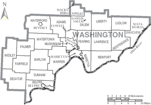
Washington County, Ohio
Encyclopedia
Washington County is a county located in the state
of Ohio
. As of the 2010 census, the population was 61,778. http://quickfacts.census.gov/qfd/states/39/39167.html Its county seat
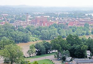
is Marietta
. The county, the oldest in the state, is named for George Washington
. Washington County is included in the Parkersburg
-Marietta
-Vienna
, West Virginia
-Ohio
Metropolitan Statistical Area
.
, the county has a total area of 640 square miles (1,657.6 km²).635 square miles (1,645 km²) of it is land and 5 square miles (12.9 km²) of it (0.78%) is water.
Washington County's southern and eastern boundary is the Ohio River
. The Muskingum River
, Little Muskingum River
, Duck Creek
, and the Little Hocking River
flow through the county to the Ohio River.
of 2000, there were 63,251 people, 25,137 households, and 17,671 families residing in the county. The population density
was 100 people per square mile (38/km²). There were 27,760 housing units at an average density of 44 per square mile (17/km²). The racial makeup of the county was 97.33% White
, 0.92% Black
or African American
, 0.24% Native American
, 0.43% Asian
, 0.05% Pacific Islander
, 0.13% from other races
, and 0.89% from two or more races. 0.51% of the population were Hispanic
or Latino
of any race. 29.5% were of German
, 23.4% American
, 12.3% English
and 11.0% Irish
ancestry according to Census 2000.
There were 25,137 households out of which 30.90% had children under the age of 18 living with them, 57.90% were married couples
living together, 9.10% had a female householder with no husband present, and 29.70% were non-families. 25.40% of all households were made up of individuals and 11.20% had someone living alone who was 65 years of age or older. The average household size was 2.45 and the average family size was 2.93.
In the county, the population was spread out with 23.50% under the age of 18, 8.80% from 18 to 24, 27.50% from 25 to 44, 25.10% from 45 to 64, and 15.00% who were 65 years of age or older. The median age was 39 years. For every 100 females there were 94.60 males. For every 100 females age 18 and over, there were 91.00 males.
The median income for a household in the county was $34,275, and the median income for a family was $41,605. Males had a median income of $32,034 versus $21,346 for females. The per capita income
for the county was $18,082. About 8.60% of families and 11.40% of the population were below the poverty line, including 15.70% of those under age 18 and 10.20% of those age 65 or over.
U.S. state
A U.S. state is any one of the 50 federated states of the United States of America that share sovereignty with the federal government. Because of this shared sovereignty, an American is a citizen both of the federal entity and of his or her state of domicile. Four states use the official title of...
of Ohio
Ohio
Ohio is a Midwestern state in the United States. The 34th largest state by area in the U.S.,it is the 7th‑most populous with over 11.5 million residents, containing several major American cities and seven metropolitan areas with populations of 500,000 or more.The state's capital is Columbus...
. As of the 2010 census, the population was 61,778. http://quickfacts.census.gov/qfd/states/39/39167.html Its county seat
County seat
A county seat is an administrative center, or seat of government, for a county or civil parish. The term is primarily used in the United States....
is Marietta
Marietta, Ohio
Marietta is a city in and the county seat of Washington County, Ohio, United States. During 1788, pioneers to the Ohio Country established Marietta as the first permanent American settlement of the new United States in the Northwest Territory. Marietta is located in southeastern Ohio at the mouth...
. The county, the oldest in the state, is named for George Washington
George Washington
George Washington was the dominant military and political leader of the new United States of America from 1775 to 1799. He led the American victory over Great Britain in the American Revolutionary War as commander-in-chief of the Continental Army from 1775 to 1783, and presided over the writing of...
. Washington County is included in the Parkersburg
Parkersburg, West Virginia
As of the census of 2000, there were 33,099 people, 14,467 households, and 8,767 families residing in the city. In 2006 the U.S. Census Bureau estimated that Parkersburg's population had decreased 4.4% to 31,755. The population density was 2,800.5 people per square mile . There were 16,100 housing...
-Marietta
Marietta, Ohio
Marietta is a city in and the county seat of Washington County, Ohio, United States. During 1788, pioneers to the Ohio Country established Marietta as the first permanent American settlement of the new United States in the Northwest Territory. Marietta is located in southeastern Ohio at the mouth...
-Vienna
Vienna, West Virginia
Vienna is a city in Wood County, West Virginia, along the Ohio River. It is a suburb of Parkersburg. The population was 10,749 at the 2010 census. It is the third largest city by population in the Parkersburg-Marietta-Vienna Metropolitan Statistical Area. Vienna was incorporated in 1935, and was...
, West Virginia
West Virginia
West Virginia is a state in the Appalachian and Southeastern regions of the United States, bordered by Virginia to the southeast, Kentucky to the southwest, Ohio to the northwest, Pennsylvania to the northeast and Maryland to the east...
-Ohio
Ohio
Ohio is a Midwestern state in the United States. The 34th largest state by area in the U.S.,it is the 7th‑most populous with over 11.5 million residents, containing several major American cities and seven metropolitan areas with populations of 500,000 or more.The state's capital is Columbus...
Metropolitan Statistical Area
Parkersburg-Marietta-Vienna metropolitan area
The Parkersburg-Marietta-Vienna Metropolitan Statistical Area, as defined by the United States Census Bureau, is an area consisting of three counties in West Virginia and one in Ohio, anchored by the cities of Parkersburg, West Virginia, Marietta, Ohio, and Vienna, West Virginia...
.
Geography
According to the U.S. Census BureauUnited States Census Bureau
The United States Census Bureau is the government agency that is responsible for the United States Census. It also gathers other national demographic and economic data...
, the county has a total area of 640 square miles (1,657.6 km²).635 square miles (1,645 km²) of it is land and 5 square miles (12.9 km²) of it (0.78%) is water.
Washington County's southern and eastern boundary is the Ohio River
Ohio River
The Ohio River is the largest tributary, by volume, of the Mississippi River. At the confluence, the Ohio is even bigger than the Mississippi and, thus, is hydrologically the main stream of the whole river system, including the Allegheny River further upstream...
. The Muskingum River
Muskingum River
The Muskingum River is a tributary of the Ohio River, approximately 111 miles long, in southeastern Ohio in the United States. An important commercial route in the 19th century, it flows generally southward through the eastern hill country of Ohio...
, Little Muskingum River
Little Muskingum River
The Little Muskingum River is a tributary of the Ohio River, approximately 65 mi long, in southeast Ohio in the United States.It rises in the hill country of Monroe County, approximately 5 mi northwest of the Ohio River and 8 mi southeast of Woodsfield...
, Duck Creek
Duck Creek (Ohio)
Duck Creek is a tributary of the Ohio River, approximately 30 mi long, in southeastern Ohio in the United States. Via the Ohio River, it is part of the Mississippi River watershed...
, and the Little Hocking River
Little Hocking River
The Little Hocking River is a small tributary of the Ohio River, long, in southeastern Ohio in the United States. Via the Ohio River, it is part of the watershed of the Mississippi River, draining an area of on the unglaciated portion of the Allegheny Plateau...
flow through the county to the Ohio River.
Adjacent counties
- Noble CountyNoble County, OhioNoble County is a county located in the state of Ohio. As of the 2010 census, the population was 14,645. Its county seat is Caldwell. Noble County is named for Rep. Warren P. Noble of the Ohio House of Representatives, who was an early settler there.-History:...
(north) - Monroe CountyMonroe County, OhioMonroe County is a county located in the state of Ohio. As of the 2010 census, the population was 14,642. Its county seat is Woodsfield and is named for James Monroe, Secretary of State when the county was formed and later President of the United States....
(northeast) - Tyler County, West Virginia (east)
- Pleasants County, West VirginiaPleasants County, West VirginiaAs of the census of 2000, there were 7,514 people, 2,887 households, and 2,136 families residing in the county. The population density was 58 people per square mile . There were 3,214 housing units at an average density of 25 per square mile...
(southeast) - Wood County, West VirginiaWood County, West VirginiaAs of the census of 2000, there were 87,986 people, 36,275 households, and 24,884 families residing in the county. The population density was 240 people per square mile . There were 39,785 housing units at an average density of 108 per square mile...
(south) - Athens CountyAthens County, OhioAs of the census of 2000, there were 62,223 people, 22,501 households, and 12,713 families residing in the county. The population density was 123 people per square mile . There were 24,901 housing units at an average density of 49 per square mile...
(southwest) - Morgan CountyMorgan County, Ohio**----...
(northwest)
Demographics
As of the censusCensus
A census is the procedure of systematically acquiring and recording information about the members of a given population. It is a regularly occurring and official count of a particular population. The term is used mostly in connection with national population and housing censuses; other common...
of 2000, there were 63,251 people, 25,137 households, and 17,671 families residing in the county. The population density
Population density
Population density is a measurement of population per unit area or unit volume. It is frequently applied to living organisms, and particularly to humans...
was 100 people per square mile (38/km²). There were 27,760 housing units at an average density of 44 per square mile (17/km²). The racial makeup of the county was 97.33% White
Race (United States Census)
Race and ethnicity in the United States Census, as defined by the Federal Office of Management and Budget and the United States Census Bureau, are self-identification data items in which residents choose the race or races with which they most closely identify, and indicate whether or not they are...
, 0.92% Black
Race (United States Census)
Race and ethnicity in the United States Census, as defined by the Federal Office of Management and Budget and the United States Census Bureau, are self-identification data items in which residents choose the race or races with which they most closely identify, and indicate whether or not they are...
or African American
Race (United States Census)
Race and ethnicity in the United States Census, as defined by the Federal Office of Management and Budget and the United States Census Bureau, are self-identification data items in which residents choose the race or races with which they most closely identify, and indicate whether or not they are...
, 0.24% Native American
Race (United States Census)
Race and ethnicity in the United States Census, as defined by the Federal Office of Management and Budget and the United States Census Bureau, are self-identification data items in which residents choose the race or races with which they most closely identify, and indicate whether or not they are...
, 0.43% Asian
Race (United States Census)
Race and ethnicity in the United States Census, as defined by the Federal Office of Management and Budget and the United States Census Bureau, are self-identification data items in which residents choose the race or races with which they most closely identify, and indicate whether or not they are...
, 0.05% Pacific Islander
Race (United States Census)
Race and ethnicity in the United States Census, as defined by the Federal Office of Management and Budget and the United States Census Bureau, are self-identification data items in which residents choose the race or races with which they most closely identify, and indicate whether or not they are...
, 0.13% from other races
Race (United States Census)
Race and ethnicity in the United States Census, as defined by the Federal Office of Management and Budget and the United States Census Bureau, are self-identification data items in which residents choose the race or races with which they most closely identify, and indicate whether or not they are...
, and 0.89% from two or more races. 0.51% of the population were Hispanic
Race (United States Census)
Race and ethnicity in the United States Census, as defined by the Federal Office of Management and Budget and the United States Census Bureau, are self-identification data items in which residents choose the race or races with which they most closely identify, and indicate whether or not they are...
or Latino
Race (United States Census)
Race and ethnicity in the United States Census, as defined by the Federal Office of Management and Budget and the United States Census Bureau, are self-identification data items in which residents choose the race or races with which they most closely identify, and indicate whether or not they are...
of any race. 29.5% were of German
Germans
The Germans are a Germanic ethnic group native to Central Europe. The English term Germans has referred to the German-speaking population of the Holy Roman Empire since the Late Middle Ages....
, 23.4% American
United States
The United States of America is a federal constitutional republic comprising fifty states and a federal district...
, 12.3% English
English people
The English are a nation and ethnic group native to England, who speak English. The English identity is of early mediaeval origin, when they were known in Old English as the Anglecynn. England is now a country of the United Kingdom, and the majority of English people in England are British Citizens...
and 11.0% Irish
Irish people
The Irish people are an ethnic group who originate in Ireland, an island in northwestern Europe. Ireland has been populated for around 9,000 years , with the Irish people's earliest ancestors recorded having legends of being descended from groups such as the Nemedians, Fomorians, Fir Bolg, Tuatha...
ancestry according to Census 2000.
There were 25,137 households out of which 30.90% had children under the age of 18 living with them, 57.90% were married couples
Marriage
Marriage is a social union or legal contract between people that creates kinship. It is an institution in which interpersonal relationships, usually intimate and sexual, are acknowledged in a variety of ways, depending on the culture or subculture in which it is found...
living together, 9.10% had a female householder with no husband present, and 29.70% were non-families. 25.40% of all households were made up of individuals and 11.20% had someone living alone who was 65 years of age or older. The average household size was 2.45 and the average family size was 2.93.
In the county, the population was spread out with 23.50% under the age of 18, 8.80% from 18 to 24, 27.50% from 25 to 44, 25.10% from 45 to 64, and 15.00% who were 65 years of age or older. The median age was 39 years. For every 100 females there were 94.60 males. For every 100 females age 18 and over, there were 91.00 males.
The median income for a household in the county was $34,275, and the median income for a family was $41,605. Males had a median income of $32,034 versus $21,346 for females. The per capita income
Per capita income
Per capita income or income per person is a measure of mean income within an economic aggregate, such as a country or city. It is calculated by taking a measure of all sources of income in the aggregate and dividing it by the total population...
for the county was $18,082. About 8.60% of families and 11.40% of the population were below the poverty line, including 15.70% of those under age 18 and 10.20% of those age 65 or over.
Communities
Villages
|
Macksburg, Ohio Macksburg is a village in Washington County, Ohio, United States, along the West Fork of Duck Creek. The population was 202 at the 2000 census.-Geography:Macksburg is located at .... Matamoras, Ohio Matamoras is a village in Washington County, Ohio, United States, along the Ohio River. It is also commonly known as New Matamoras. The population was 957 at the 2000 census.... |
Townships
|
Grandview Township, Washington County, Ohio Grandview Township is one of the twenty-two townships of Washington County, Ohio, United States. The 2000 census found 1,834 people in the township, 877 of whom lived in the unincorporated portions of the township.-Geography:... Independence Township, Washington County, Ohio Independence Township is one of the twenty-two townships of Washington County, Ohio, United States. The 2000 census found 387 people in the township.-Geography:... Lawrence Township, Washington County, Ohio Lawrence Township is one of the twenty-two townships of Washington County, Ohio, United States. The 2000 census found 956 people in the township.-Geography:Located in the eastern part of the county, it borders the following townships:... Liberty Township, Washington County, Ohio Liberty Township is one of the twenty-two townships of Washington County, Ohio, United States. The 2000 census found 621 people in the township.-Geography:Located in the northeastern part of the county, it borders the following townships:... Ludlow Township, Washington County, Ohio Ludlow Township is one of the twenty-two townships of Washington County, Ohio, United States. The 2000 census found 330 people in the township.-Geography:Located in the northeastern part of the county, it borders the following townships:... Marietta Township, Washington County, Ohio Marietta Township is one of the twenty-two townships of Washington County, Ohio, United States. The 2000 census found 4,673 people in the township.-Geography:... Muskingum Township, Washington County, Ohio Muskingum Township is one of the twenty-two townships of Washington County, Ohio, United States. The 2000 census found 4,627 people in the township.-Geography:Located in the central part of the county, it borders the following townships:... |
Newport Township, Washington County, Ohio Newport Township is one of the twenty-two townships of Washington County, Ohio, United States. The 2000 census found 2,176 people in the township.-Geography:... Palmer Township, Washington County, Ohio Palmer Township is one of the twenty-two townships of Washington County, Ohio, United States. The 2000 census found 625 people in the township.-Geography:Located in the western part of the county, it borders the following townships:... Salem Township, Washington County, Ohio Salem Township is one of the twenty-two townships of Washington County, Ohio, United States. The 2000 census found 1,130 people in the township, 1,021 of whom lived in the unincorporated portions of the township.-Geography:... Warren Township, Washington County, Ohio Warren Township is one of the twenty-two townships of Washington County, Ohio, United States. The 2000 census found 4,044 people in the township.-Geography:Located in the southern part of the county along the Ohio River, it borders the following townships:... Waterford Township, Washington County, Ohio Waterford Township is one of the twenty-two townships of Washington County, Ohio, United States. The 2000 census found 3,708 people in the township, 2,426 of whom lived in the unincorporated portions of the township.-Geography:... Watertown Township, Washington County, Ohio Watertown Township is one of the twenty-two townships of Washington County, Ohio, United States. The 2000 census found 1,563 people in the township.-Geography:Located in the northwestern part of the county, it borders the following townships:... Wesley Township, Washington County, Ohio Wesley Township is one of the twenty-two townships of Washington County, Ohio, United States. The 2000 census found 915 people in the township.-Geography:Located in the far western part of the county, it borders the following townships:... |
Other communities
|
Germantown, Washington County, Ohio Germantown is an unincorporated community in northern Liberty Township, Washington County, Ohio, United States. It lies along the Paw Paw Creek near the boundary with Noble County.-References:... Little Hocking, Ohio Little Hocking is a census-designated place in southern Belpre Township, Washington County, Ohio, United States. Although it is unincorporated, it has a post office, with the ZIP code of 45742.... Reno, Ohio Reno is an unincorporated community in southern Marietta Township, Washington County, Ohio, United States. Although it is unincorporated, it has a post office, with the ZIP code of 45773. It is located on the Ohio River a short distance above the county seat of Marietta. State Route 7 forms its... Vincent, Ohio Vincent is an unincorporated community in southern Barlow Township, Washington County, Ohio, United States. Although it is unincorporated, it has a post office, with the ZIP code of 45784... |
Waterford, Ohio Waterford is an unincorporated community in central Waterford Township, Washington County, Ohio, United States. Although it is unincorporated, it has a post office, with the ZIP code of 45786. It is located on State Route 339 across the Muskingum River from the village of Beverly, slightly below... Watertown, Ohio Watertown is an unincorporated community in southwestern Watertown Township, Washington County, Ohio, United States. Although it is unincorporated, it has a post office, with the ZIP code of 45787... Whipple, Ohio Whipple is an unincorporated community in southern Salem Township, Washington County, Ohio, United States. Although it is unincorporated, it has a post office, with the ZIP code of 45788. It lies on State Route 821 south of the village of Lower Salem, at the junction of Whipple Run with Duck... Wingett Run, Ohio Wingett Run is an unincorporated community in western Ludlow Township, Washington County, Ohio, United States. Although it is unincorporated, it has a post office, with the ZIP code of 45789. It is located along State Route 26 and the Little Muskingum River.... |
Also see
- Covered bridges of southeast OhioCovered bridges of southeast Ohio-Athens County:Athens County features three of these preserved structures:*Blackwood Covered BridgeThis is a bridge over the Middle Branch of the Shade River in Lodi Township. It is on Blackwood Road just east of its intersection with Zion Road . It is approximately seventy feet long...
- National Register of Historic Places listings in Washington County, Ohio