
Columbia County, Pennsylvania
Encyclopedia
As of the census
of 2000, there were 64,151 people, 24,915 households, and 16,568 families residing in the county. The population density
was 132 people per square mile (51/km²). There were 27,733 housing units at an average density of 57 per square mile (22/km²). The racial makeup of the county was 97.59% White
, 0.80% Black
or African American
, 0.15% Native American
, 0.52% Asian
, 0.03% Pacific Islander
, 0.33% from other races
, and 0.58% from two or more races. 0.95% of the population were Hispanic
or Latino
of any race. 33.2% were of German, 10.0% American
, 9.4% Irish
, 8.1% Italian
, 6.7% Polish and 6.2% English
ancestry according to Census 2000.
There were 24,915 households out of which 27.70% had children under the age of 18 living with them, 53.80% were married couples
living together, 8.70% had a female householder with no husband present, and 33.50% were non-families. 26.60% of all households were made up of individuals and 11.80% had someone living alone who was 65 years of age or older. The average household size was 2.42 and the average family size was 2.90.
In the county, the population was spread out with 20.80% under the age of 18, 14.30% from 18 to 24, 25.90% from 25 to 44, 23.10% from 45 to 64, and 15.90% who were 65 years of age or older. The median age was 38 years. For every 100 females there were 90.80 males. For every 100 females age 18 and over, there were 87.80 males.
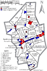
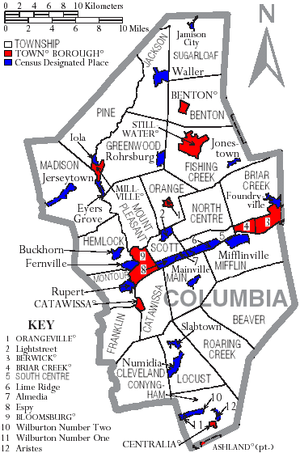 Under Pennsylvania law, there are four types of incorporated municipalities: cities, boroughs, townships, and, in at most two cases, towns. The following town, boroughs and townships are located in Columbia County:
s are geographical areas designated by the U.S. Census Bureau
for the purposes of compiling demographic data. They are not actual jurisdictions under Pennsylvania law. Other unincorporated communities, such as villages, may be listed here as well.
Census
A census is the procedure of systematically acquiring and recording information about the members of a given population. It is a regularly occurring and official count of a particular population. The term is used mostly in connection with national population and housing censuses; other common...
of 2000, there were 64,151 people, 24,915 households, and 16,568 families residing in the county. The population density
Population density
Population density is a measurement of population per unit area or unit volume. It is frequently applied to living organisms, and particularly to humans...
was 132 people per square mile (51/km²). There were 27,733 housing units at an average density of 57 per square mile (22/km²). The racial makeup of the county was 97.59% White
Race (United States Census)
Race and ethnicity in the United States Census, as defined by the Federal Office of Management and Budget and the United States Census Bureau, are self-identification data items in which residents choose the race or races with which they most closely identify, and indicate whether or not they are...
, 0.80% Black
Race (United States Census)
Race and ethnicity in the United States Census, as defined by the Federal Office of Management and Budget and the United States Census Bureau, are self-identification data items in which residents choose the race or races with which they most closely identify, and indicate whether or not they are...
or African American
Race (United States Census)
Race and ethnicity in the United States Census, as defined by the Federal Office of Management and Budget and the United States Census Bureau, are self-identification data items in which residents choose the race or races with which they most closely identify, and indicate whether or not they are...
, 0.15% Native American
Race (United States Census)
Race and ethnicity in the United States Census, as defined by the Federal Office of Management and Budget and the United States Census Bureau, are self-identification data items in which residents choose the race or races with which they most closely identify, and indicate whether or not they are...
, 0.52% Asian
Race (United States Census)
Race and ethnicity in the United States Census, as defined by the Federal Office of Management and Budget and the United States Census Bureau, are self-identification data items in which residents choose the race or races with which they most closely identify, and indicate whether or not they are...
, 0.03% Pacific Islander
Race (United States Census)
Race and ethnicity in the United States Census, as defined by the Federal Office of Management and Budget and the United States Census Bureau, are self-identification data items in which residents choose the race or races with which they most closely identify, and indicate whether or not they are...
, 0.33% from other races
Race (United States Census)
Race and ethnicity in the United States Census, as defined by the Federal Office of Management and Budget and the United States Census Bureau, are self-identification data items in which residents choose the race or races with which they most closely identify, and indicate whether or not they are...
, and 0.58% from two or more races. 0.95% of the population were Hispanic
Race (United States Census)
Race and ethnicity in the United States Census, as defined by the Federal Office of Management and Budget and the United States Census Bureau, are self-identification data items in which residents choose the race or races with which they most closely identify, and indicate whether or not they are...
or Latino
Race (United States Census)
Race and ethnicity in the United States Census, as defined by the Federal Office of Management and Budget and the United States Census Bureau, are self-identification data items in which residents choose the race or races with which they most closely identify, and indicate whether or not they are...
of any race. 33.2% were of German, 10.0% American
United States
The United States of America is a federal constitutional republic comprising fifty states and a federal district...
, 9.4% Irish
Irish people
The Irish people are an ethnic group who originate in Ireland, an island in northwestern Europe. Ireland has been populated for around 9,000 years , with the Irish people's earliest ancestors recorded having legends of being descended from groups such as the Nemedians, Fomorians, Fir Bolg, Tuatha...
, 8.1% Italian
Italian people
The Italian people are an ethnic group that share a common Italian culture, ancestry and speak the Italian language as a mother tongue. Within Italy, Italians are defined by citizenship, regardless of ancestry or country of residence , and are distinguished from people...
, 6.7% Polish and 6.2% English
English people
The English are a nation and ethnic group native to England, who speak English. The English identity is of early mediaeval origin, when they were known in Old English as the Anglecynn. England is now a country of the United Kingdom, and the majority of English people in England are British Citizens...
ancestry according to Census 2000.
There were 24,915 households out of which 27.70% had children under the age of 18 living with them, 53.80% were married couples
Marriage
Marriage is a social union or legal contract between people that creates kinship. It is an institution in which interpersonal relationships, usually intimate and sexual, are acknowledged in a variety of ways, depending on the culture or subculture in which it is found...
living together, 8.70% had a female householder with no husband present, and 33.50% were non-families. 26.60% of all households were made up of individuals and 11.80% had someone living alone who was 65 years of age or older. The average household size was 2.42 and the average family size was 2.90.
In the county, the population was spread out with 20.80% under the age of 18, 14.30% from 18 to 24, 25.90% from 25 to 44, 23.10% from 45 to 64, and 15.90% who were 65 years of age or older. The median age was 38 years. For every 100 females there were 90.80 males. For every 100 females age 18 and over, there were 87.80 males.
Municipalities
Boroughs
|
Briar Creek, Pennsylvania Briar Creek is a borough in Columbia County, Pennsylvania, United States. The population was 651 at the 2000 census. It is part of the Bloomsburg–Berwick Micropolitan Statistical Area.-Geography:Briar Creek is located at .... Catawissa, Pennsylvania Catawissa is a borough in Columbia County, Pennsylvania, United States. The population was 1,589 at the 2000 census. It is part of the Bloomsburg–Berwick Micropolitan Statistical Area.... Centralia, Pennsylvania Centralia is a borough and ghost town in Columbia County, Pennsylvania, United States. Its population has dwindled from over 1,000 residents in 1981 to 12 in 2005, 9 in 2007, and 10 in 2010, as a result of a mine fire burning beneath the borough since 1962... |
Millville, Pennsylvania Millville is a borough in Columbia County, Pennsylvania, United States. It is part of the Bloomsburg–Berwick Micropolitan Statistical Area.-History:... Orangeville, Pennsylvania Orangeville is a borough in Columbia County, Pennsylvania. The population was 500 at the 2000 census. It is part of the Bloomsburg–Berwick Micropolitan Statistical Area.-Geography:Orangeville is located at .... Stillwater, Pennsylvania Stillwater is a borough in Columbia County, Pennsylvania, United States. The population was 194 at the 2000 census. It is part of the Bloomsburg–Berwick Micropolitan Statistical Area.-Geography:Stillwater is located at .... |
Townships
|
Greenwood Township, Columbia County, Pennsylvania Greenwood Township is a township in Columbia County, Pennsylvania, United States. The population was 1,932 at the 2000 census.-Geography:According to the United States Census Bureau, the township has a total area of .27.9 square miles of it is land and of it is water.-Demographics:As of the... Jackson Township, Columbia County, Pennsylvania Jackson Township is a township in Columbia County, Pennsylvania, United States. The population was 598 at the 2000 census.-Geography:According to the United States Census Bureau, the township has a total area of , all of it land.-Demographics:... Madison Township, Columbia County, Pennsylvania Madison Township is a township in Columbia County, Pennsylvania, United States. The population was 1,590 at the 2000 census.-Geography:According to the United States Census Bureau, the township has a total area of 35.3 square miles , of which, 35.3 square miles of it is land and... Mifflin Township, Columbia County, Pennsylvania Mifflin Township is a township in Columbia County, Pennsylvania, United States. The population was 2,251 at the 2000 census.-Geography:According to the United States Census Bureau, the township has a total area of 20.0 square miles , of which, 19.2 square miles of it is land and... |
Mount Pleasant Township, Columbia County, Pennsylvania Mount Pleasant Township is a township in Columbia County, Pennsylvania, in the United States. As of the 2000 census, the township population was 1,459.-Geography:... Pine Township, Columbia County, Pennsylvania Pine Township is a township in Columbia County, Pennsylvania, United States. The population was 1,092 at the 2000 census.-Geography:According to the United States Census Bureau, the township has a total area of 26.6 square miles , all of it land.-Demographics:As of the census of 2000, there... Scott Township, Columbia County, Pennsylvania Scott Township is a township in Columbia County, Pennsylvania, United States. The population was 4,768 at the 2000 census.-Geography:According to the United States Census Bureau, the township has a total area of 7.4 square miles , of which, 7.1 square miles of it is land and... Sugarloaf Township, Columbia County, Pennsylvania Sugarloaf Township is a township in Columbia County, Pennsylvania, United States. The population was 885 at the 2000 census.-Geography:According to the United States Census Bureau, the township has a total area of 25.9 square miles , of which, 25.9 square miles of it is land and... |
Census-designated places
Census-designated placeCensus-designated place
A census-designated place is a concentration of population identified by the United States Census Bureau for statistical purposes. CDPs are delineated for each decennial census as the statistical counterparts of incorporated places such as cities, towns and villages...
s are geographical areas designated by the U.S. Census Bureau
United States Census Bureau
The United States Census Bureau is the government agency that is responsible for the United States Census. It also gathers other national demographic and economic data...
for the purposes of compiling demographic data. They are not actual jurisdictions under Pennsylvania law. Other unincorporated communities, such as villages, may be listed here as well.
|
Jamison City, Pennsylvania Jamison City is a census-designated place in Sugarloaf Township Columbia County, Pennsylvania, United States. The population was 102 at the 2000 census... Jerseytown, Pennsylvania Jerseytown is a census-designated place in Madison Township, Columbia County, Pennsylvania, United States. The population was 150 at the 2000 census... Jonestown, Columbia County, Pennsylvania Jonestown is a census-designated place in Columbia County, Pennsylvania, United States. The population was 34 at the 2000 census. It is part of the Bloomsburg–Berwick Micropolitan Statistical Area.-Geography:... Lightstreet, Pennsylvania Lightstreet is a census-designated place in Columbia County, Pennsylvania, United States. The population was 881 at the 2000 census. It is part of the Bloomsburg–Berwick Micropolitan Statistical Area.-Geography:... Lime Ridge, Pennsylvania Lime Ridge is a census-designated place in Columbia County, Pennsylvania, United States. The population was 951 at the 2000 census. It is part of the Bloomsburg–Berwick Micropolitan Statistical Area.-Geography:... Locustdale, Pennsylvania Locustdale is a census-designated place in Columbia, Schuylkill, and Northumberland counties in Pennsylvania, United States. The population was 70 at the 2000 census... Mainville, Pennsylvania Mainville is a census-designated place in Columbia County, Pennsylvania, United States. The population was 83 at the 2000 census. It is part of the Bloomsburg–Berwick Micropolitan Statistical Area.-Geography:... Mifflinville, Pennsylvania Mifflinville is a census-designated place in Columbia County, Pennsylvania, United States. The population was 71 at the 2000 census. It is part of the Bloomsburg–Berwick Micropolitan Statistical Area.-Geography:... |
Numidia, Pennsylvania Numidia is a census-designated place in Columbia County, Pennsylvania, United States. The population was 254 at the 2000 census. It is part of the Bloomsburg–Berwick Micropolitan Statistical Area.-Geography:... Rohrsburg, Pennsylvania Rohrsburg is a census-designated place in Columbia County, Pennsylvania, United States. The population was 164 at the 2000 census. It is part of the Bloomsburg–Berwick Micropolitan Statistical Area.-Geography:... Rupert, Pennsylvania Rupert is a census-designated place in Columbia County, Pennsylvania, United States. The population was 174 at the 2000 census. It is part of the Bloomsburg–Berwick Micropolitan Statistical Area.-Geography:... Slabtown, Pennsylvania Slabtown is a census-designated place in Columbia County, Pennsylvania, United States. The population was 105 at the 2000 census. It is part of the Bloomsburg–Berwick Micropolitan Statistical Area.-Geography:... Waller, Pennsylvania Waller is a census-designated place in Columbia County, Pennsylvania, United States. The population was 55 at the 2000 census. It is part of the Bloomsburg–Berwick Micropolitan Statistical Area.-Geography:... Wilburton Number One, Pennsylvania Wilburton Number One is a census-designated place in Columbia County, Pennsylvania, United States. The population was 248 at the 2000 census... Wilburton Number Two, Pennsylvania Wilburton Number Two is a census-designated place in Columbia County, Pennsylvania, United States. The population was 77 at the 2000 census... |
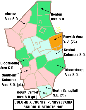
Public School Districts
- Benton Area School DistrictBenton Area School DistrictThe Benton Area School District is a small, rural, public school district. It encompasses 96.8 square miles. It covers the Boroughs of Benton and Stillwater and Benton Township, Fishing Creek Township, Jackson Township and Sugarloaf Township in Columbia County, Pennsylvania. The district operates...
- Berwick Area School DistrictBerwick Area School DistrictThe Berwick Area School District is a midsized, public school district. Berwick Area School District encompasses approximately 101 square miles, spanning portions of two rural Pennsylvania counties. In Columbia County it covers the Boroughs of Berwick and Briar Creek and Briar Creek Township...
(also in Luzerne County) - Bloomsburg Area School DistrictBloomsburg Area School DistrictThe Bloomsburg Area School District is one of the 500 school districts of Pennsylvania. The district covers the Town of Bloomsburg and Beaver Township, Hemlock Township, Main Township and Montour Township in Columbia County, Pennsylvania. The district encompasses approximately 81 square miles...
- Central Columbia School DistrictCentral Columbia School DistrictThe Central Columbia School District is a small, rural, public school district that covers the Borough of Orangeville and Mifflin Township, Mount Pleasant Township, North Centre Township, Orange Township, Scott Township and South Centre Township in Columbia County, Pennsylvania. According to 2000...
- Millville Area School DistrictMillville Area School DistrictThe Millville Area School District is a public school district in Columbia County, Pennsylvania. It is centered in the borough of Millville and also encompasses the townships of Pine, Greenwood, and Madison. Millville Area School District encompasses approximately 91 square miles. According to 2000...
- Mount Carmel Area School DistrictMount Carmel Area School DistrictMount Carmel Area School District is a small, suburban, public school district in Northumberland County, Pennsylvania. It serves Mount Carmel, Kulpmont, Marion Heights, and...
(also in Northumberland County) - North Schuylkill School DistrictNorth Schuylkill School DistrictThe North Schuylkill School District is a public school district in Schuylkill County, Pennsylvania and Columbia County, Pennsylvania. It includes the municipalities of Frackville, Ringtown, Union Township, Girardville, Fountain Springs, Ashland, Gordon, and Butler Township in Schuylkill County,...
(also in Schuylkill County) - Southern Columbia Area School DistrictSouthern Columbia Area School DistrictSouthern Columbia Area School District is a small, rural school district located in Catawissa, Pennsylvania. It is in Columbia County and draws students from both Columbia and Northumberland counties. Southern Columbia Area School District encompasses approximately 108 square miles. According to...
(also in Northumberland County)
See also
- List of municipal authorities in Columbia County, Pennsylvania
- National Register of Historic Places listings in Columbia County, PennsylvaniaNational Register of Historic Places listings in Columbia County, PennsylvaniaThis is a list of the National Register of Historic Places listings in Columbia County, Pennsylvania.This is intended to be a complete list of the properties and districts on the National Register of Historic Places in Columbia County, Pennsylvania, United States...