

Coshocton County, Ohio
Encyclopedia
Coshocton County is a county located in the state
of Ohio
, United States
. As of the 2010 census, the population was 36,901. http://quickfacts.census.gov/qfd/states/39/39031.html Its county seat
is Coshocton
. Its name comes from the Delaware Indian
language and has been translated as "union of waters" or "black bear crossing".
The Coshocton Micropolitan Statistical Area includes all of Coshocton County.
, the county has a total area of 568 square miles (1,471.1 km²).564 square miles (1,460.8 km²) is land and 4 square miles (10.4 km²) (0.62%) is water.
word that roughly means "union of waters."
of 2000, there were 36,655 people, 14,356 households, and 10,164 families residing in the county. The population density
was 65 people per square mile (25/km²). There were 16,107 housing units at an average density of 29 per square mile (11/km²). The racial makeup of the county was 97.35% White
, 1.09% Black
or African American
, 0.17% Native American
, 0.32% Asian
, 0.03% Pacific Islander
, 0.20% from other races
, and 0.84% from two or more races. 0.59% of the population were Hispanic
or Latino
of any race. 29.4% were of German
, 23.4% American
, 11.6% English
and 9.3% Irish
ancestry according to Census 2000. 93.9% spoke English
, 2.4% German
and 1.5% Pennsylvania Dutch
as their first language.
There were 14,356 households out of which 32.60% had children under the age of 18 living with them, 57.80% were married couples
living together, 9.20% had a female householder with no husband present, and 29.20% were non-families. 25.40% of all households were made up of individuals and 11.90% had someone living alone who was 65 years of age or older. The average household size was 2.52 and the average family size was 3.01.
In the county the population was spread out with 26.20% under the age of 18, 7.80% from 18 to 24, 27.40% from 25 to 44, 24.00% from 45 to 64, and 14.70% who were 65 years of age or older. The median age was 38 years. For every 100 females there were 95.50 males. For every 100 females age 18 and over, there were 92.70 males.
The median income for a household in the county was $34,701, and the median income for a family was $41,676. Males had a median income of $31,095 versus $21,276 for females. The per capita income
for the county was $16,364. About 7.00% of families and 9.10% of the population were below the poverty line, including 10.40% of those under age 18 and 9.10% of those age 65 or over.
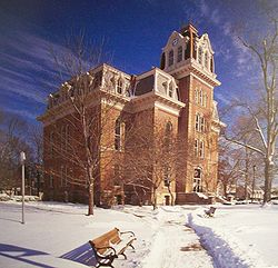 The county courts meet in the courthouse located in Coshocton. Built in 1875, it is still in use today.
U.S. state
A U.S. state is any one of the 50 federated states of the United States of America that share sovereignty with the federal government. Because of this shared sovereignty, an American is a citizen both of the federal entity and of his or her state of domicile. Four states use the official title of...
of Ohio
Ohio
Ohio is a Midwestern state in the United States. The 34th largest state by area in the U.S.,it is the 7th‑most populous with over 11.5 million residents, containing several major American cities and seven metropolitan areas with populations of 500,000 or more.The state's capital is Columbus...
, United States
United States
The United States of America is a federal constitutional republic comprising fifty states and a federal district...
. As of the 2010 census, the population was 36,901. http://quickfacts.census.gov/qfd/states/39/39031.html Its county seat
County seat
A county seat is an administrative center, or seat of government, for a county or civil parish. The term is primarily used in the United States....
is Coshocton
Coshocton, Ohio
Coshocton is a city in and the county seat of Coshocton County, Ohio, United States. The population of the city was 11,682 at the 2000 census. The Walhonding River and the Tuscarawas River meet in Coshocton to form the Muskingum River....
. Its name comes from the Delaware Indian
Lenape
The Lenape are an Algonquian group of Native Americans of the Northeastern Woodlands. They are also called Delaware Indians. As a result of the American Revolutionary War and later Indian removals from the eastern United States, today the main groups live in Canada, where they are enrolled in the...
language and has been translated as "union of waters" or "black bear crossing".
The Coshocton Micropolitan Statistical Area includes all of Coshocton County.
Geography
According to the U.S. Census BureauUnited States Census Bureau
The United States Census Bureau is the government agency that is responsible for the United States Census. It also gathers other national demographic and economic data...
, the county has a total area of 568 square miles (1,471.1 km²).564 square miles (1,460.8 km²) is land and 4 square miles (10.4 km²) (0.62%) is water.
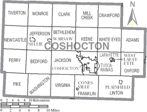
Adjacent counties
- Holmes CountyHolmes County, OhioAs of the census of 2000, there were 38,943 people, 11,337 households, and 9,194 families residing in the county. The population density was 92 people per square mile . There were 12,280 housing units at an average density of 29 per square mile...
(north) - Tuscawaras CountyTuscarawas County, OhioTuscarawas County is a county located in the eastern part of the state of Ohio. As of the 2010 census, the population was 92,582. Its county seat is New Philadelphia...
(east) - Guernsey CountyGuernsey County, OhioGuernsey County is a county located in the state of Ohio. As of 2010, the population was 40,087. Its county seat is Cambridge and is named for the Isle of Guernsey in the English Channel, from which many of the county's early settlers came....
(southeast) - Muskingum CountyMuskingum County, OhioMuskingum County is a county located in the state of Ohio, United States. As of the 2010 census, the population was 86,074. Its county seat is Zanesville...
(south) - Licking CountyLicking County, OhioLicking County is a county located in the state of Ohio, United States. As of the 2010 census, the population was 166,492. Its county seat is Newark and is named for the salt licks that were in the area....
(southwest) - Knox CountyKnox County, OhioKnox County is a county located in the state of Ohio, United States. As of 2010, the population was 60,921. Its county seat is Mount Vernon and is named for Henry Knox, an officer in the American Revolutionary War who was later the first Secretary of War....
(west)
History
Coshocton County was formed on January 31, 1810 from portions of Muskingum and Tuscarawas counties. Its name is derived from a Delaware IndianLenape
The Lenape are an Algonquian group of Native Americans of the Northeastern Woodlands. They are also called Delaware Indians. As a result of the American Revolutionary War and later Indian removals from the eastern United States, today the main groups live in Canada, where they are enrolled in the...
word that roughly means "union of waters."
Demographics
As of the censusCensus
A census is the procedure of systematically acquiring and recording information about the members of a given population. It is a regularly occurring and official count of a particular population. The term is used mostly in connection with national population and housing censuses; other common...
of 2000, there were 36,655 people, 14,356 households, and 10,164 families residing in the county. The population density
Population density
Population density is a measurement of population per unit area or unit volume. It is frequently applied to living organisms, and particularly to humans...
was 65 people per square mile (25/km²). There were 16,107 housing units at an average density of 29 per square mile (11/km²). The racial makeup of the county was 97.35% White
Race (United States Census)
Race and ethnicity in the United States Census, as defined by the Federal Office of Management and Budget and the United States Census Bureau, are self-identification data items in which residents choose the race or races with which they most closely identify, and indicate whether or not they are...
, 1.09% Black
Race (United States Census)
Race and ethnicity in the United States Census, as defined by the Federal Office of Management and Budget and the United States Census Bureau, are self-identification data items in which residents choose the race or races with which they most closely identify, and indicate whether or not they are...
or African American
Race (United States Census)
Race and ethnicity in the United States Census, as defined by the Federal Office of Management and Budget and the United States Census Bureau, are self-identification data items in which residents choose the race or races with which they most closely identify, and indicate whether or not they are...
, 0.17% Native American
Race (United States Census)
Race and ethnicity in the United States Census, as defined by the Federal Office of Management and Budget and the United States Census Bureau, are self-identification data items in which residents choose the race or races with which they most closely identify, and indicate whether or not they are...
, 0.32% Asian
Race (United States Census)
Race and ethnicity in the United States Census, as defined by the Federal Office of Management and Budget and the United States Census Bureau, are self-identification data items in which residents choose the race or races with which they most closely identify, and indicate whether or not they are...
, 0.03% Pacific Islander
Race (United States Census)
Race and ethnicity in the United States Census, as defined by the Federal Office of Management and Budget and the United States Census Bureau, are self-identification data items in which residents choose the race or races with which they most closely identify, and indicate whether or not they are...
, 0.20% from other races
Race (United States Census)
Race and ethnicity in the United States Census, as defined by the Federal Office of Management and Budget and the United States Census Bureau, are self-identification data items in which residents choose the race or races with which they most closely identify, and indicate whether or not they are...
, and 0.84% from two or more races. 0.59% of the population were Hispanic
Race (United States Census)
Race and ethnicity in the United States Census, as defined by the Federal Office of Management and Budget and the United States Census Bureau, are self-identification data items in which residents choose the race or races with which they most closely identify, and indicate whether or not they are...
or Latino
Race (United States Census)
Race and ethnicity in the United States Census, as defined by the Federal Office of Management and Budget and the United States Census Bureau, are self-identification data items in which residents choose the race or races with which they most closely identify, and indicate whether or not they are...
of any race. 29.4% were of German
Germans
The Germans are a Germanic ethnic group native to Central Europe. The English term Germans has referred to the German-speaking population of the Holy Roman Empire since the Late Middle Ages....
, 23.4% American
United States
The United States of America is a federal constitutional republic comprising fifty states and a federal district...
, 11.6% English
English people
The English are a nation and ethnic group native to England, who speak English. The English identity is of early mediaeval origin, when they were known in Old English as the Anglecynn. England is now a country of the United Kingdom, and the majority of English people in England are British Citizens...
and 9.3% Irish
Irish people
The Irish people are an ethnic group who originate in Ireland, an island in northwestern Europe. Ireland has been populated for around 9,000 years , with the Irish people's earliest ancestors recorded having legends of being descended from groups such as the Nemedians, Fomorians, Fir Bolg, Tuatha...
ancestry according to Census 2000. 93.9% spoke English
English language
English is a West Germanic language that arose in the Anglo-Saxon kingdoms of England and spread into what was to become south-east Scotland under the influence of the Anglian medieval kingdom of Northumbria...
, 2.4% German
German language
German is a West Germanic language, related to and classified alongside English and Dutch. With an estimated 90 – 98 million native speakers, German is one of the world's major languages and is the most widely-spoken first language in the European Union....
and 1.5% Pennsylvania Dutch
Pennsylvania German language
The Pennsylvania German language is a variety of West Central German possibly spoken by more than 250,000 people in North America...
as their first language.
There were 14,356 households out of which 32.60% had children under the age of 18 living with them, 57.80% were married couples
Marriage
Marriage is a social union or legal contract between people that creates kinship. It is an institution in which interpersonal relationships, usually intimate and sexual, are acknowledged in a variety of ways, depending on the culture or subculture in which it is found...
living together, 9.20% had a female householder with no husband present, and 29.20% were non-families. 25.40% of all households were made up of individuals and 11.90% had someone living alone who was 65 years of age or older. The average household size was 2.52 and the average family size was 3.01.
In the county the population was spread out with 26.20% under the age of 18, 7.80% from 18 to 24, 27.40% from 25 to 44, 24.00% from 45 to 64, and 14.70% who were 65 years of age or older. The median age was 38 years. For every 100 females there were 95.50 males. For every 100 females age 18 and over, there were 92.70 males.
The median income for a household in the county was $34,701, and the median income for a family was $41,676. Males had a median income of $31,095 versus $21,276 for females. The per capita income
Per capita income
Per capita income or income per person is a measure of mean income within an economic aggregate, such as a country or city. It is calculated by taking a measure of all sources of income in the aggregate and dividing it by the total population...
for the county was $16,364. About 7.00% of families and 9.10% of the population were below the poverty line, including 10.40% of those under age 18 and 9.10% of those age 65 or over.
Government
Communities
Villages
|
Nellie, Ohio Nellie is a village in Coshocton County, Ohio, United States, along the Walhonding River. The population was 134 at the 2000 census.The 1930s-era Mohawk Dam, a dry dam built for flood control, is just to the north and west of the village.-Geography:... Plainfield, Ohio Plainfield is a village in Coshocton County, Ohio, United States, along Wills Creek. The population was 158 at the 2000 census.-Geography:Plainfield is located at .... |
Warsaw, Ohio Warsaw is a village in Coshocton County, Ohio, United States, along the Walhonding River. The population was 781 at the 2000 census.-Geography:Warsaw is located at .... West Lafayette, Ohio West Lafayette is a village in Coshocton County, Ohio, United States. The population was 2,313 at the 2000 census.-History:West Lafayette was laid out in 1850 by Robert Shaw and William Wheeler. In 1855, the Steubenville and Indiana Railroad was built through the new town... |
Townships
|
Jackson Township, Coshocton County, Ohio Jackson Township is one of the twenty-two townships of Coshocton County, Ohio, United States. The 2000 census found 2,045 people in the township.-Geography:Located in the south central part of the county, it borders the following townships:... Jefferson Township, Coshocton County, Ohio Jefferson Township is one of the twenty-two townships of Coshocton County, Ohio, United States. The 2000 census found 1,549 people in the township, 634 of whom lived in the unincorporated portions of the township.-Geography:... Keene Township, Coshocton County, Ohio Keene Township is one of the twenty-two townships of Coshocton County, Ohio, United States. The 2000 census found 1,689 people in the township.-Geography:Located in the north central part of the county, it borders the following townships:... Lafayette Township, Coshocton County, Ohio Lafayette Township is one of the twenty-two townships of Coshocton County, Ohio, United States. The 2000 census found 4,285 people in the township, 1,972 of whom lived in the unincorporated portions of the township.-Geography:... Linton Township, Coshocton County, Ohio Linton Township is one of the twenty-two townships of Coshocton County, Ohio, United States. The 2000 census found 632 people in the township, 474 of whom lived in the unincorporated portions of the township.-Geography:... Mill Creek Township, Coshocton County, Ohio Mill Creek Township is one of the twenty-two townships of Coshocton County, Ohio, United States. The 2000 census found 747 people in the township.-Geography:Located in the northern part of the county, it borders the following townships:... |
Monroe Township, Coshocton County, Ohio Monroe Township is one of the twenty-two townships of Coshocton County, Ohio, United States. The 2000 census found 452 people in the township.-Geography:Located in the northwestern part of the county, it borders the following townships:... Newcastle Township, Coshocton County, Ohio Newcastle Township is one of the twenty-two townships of Coshocton County, Ohio, United States. The 2000 census found 441 people in the township.-Geography:Located in the far western part of the county, it borders the following townships:... Oxford Township, Coshocton County, Ohio Oxford Township is one of the twenty-two townships of Coshocton County, Ohio, United States. The 2000 census found 1,560 people in the township.-Geography:Located in the far eastern part of the county, it borders the following townships:... Perry Township, Coshocton County, Ohio Perry Township is one of the twenty-two townships of Coshocton County, Ohio, United States. The 2000 census found 513 people in the township.-Geography:Located in the far western part of the county, it borders the following townships:... Pike Township, Coshocton County, Ohio Pike Township is one of the twenty-two townships of Coshocton County, Ohio, United States. The 2000 census found 550 people in the township.-Geography:Located in the southwestern corner of the county, it borders the following townships:... |
Tiverton Township, Coshocton County, Ohio Tiverton Township is one of the twenty-two townships of Coshocton County, Ohio, United States. The 2000 census found 348 people in the township.-Geography:Located in the northwestern corner of the county, it borders the following townships:... Tuscarawas Township, Coshocton County, Ohio Tuscarawas Township is one of the twenty-two townships of Coshocton County, Ohio, United States. The 2000 census found 1,798 people in the township.-Geography:Located in the south central part of the county, it borders the following townships:... Virginia Township, Coshocton County, Ohio Virginia Township is one of the twenty-two townships of Coshocton County, Ohio, United States. The 2000 census found 636 people in the township.-Geography:Located in the southern part of the county, it borders the following townships:... Washington Township, Coshocton County, Ohio Washington Township is one of the twenty-two townships of Coshocton County, Ohio, United States. The 2000 census found 629 people in the township.-Geography:Located in the southeastern part of the county, it borders the following townships:... White Eyes Township, Coshocton County, Ohio White Eyes Township is one of the twenty-two townships of Coshocton County, Ohio, United States. The 2000 census found 1,078 people in the township.-Geography:Located in the northeastern part of the county, it borders the following townships:... |
Unincorporated communities
|
Fresno, Ohio Fresno is a census-designated place in eastern White Eyes Township, Coshocton County, Ohio, United States. Although it is unincorporated, it has a post office, with the ZIP code of 43824. It lies along State Route 93 between West Lafayette and Baltic.... Keene, Ohio Keene is an unincorporated community in central Keene Township, Coshocton County, Ohio, United States. Although it is unincorporated, it has a post office, with the ZIP code of 43828.-References:... |
Tunnel Hill, Ohio Tunnel Hill is an unincorporated place in central Bedford Township, Coshocton County, Ohio, United States. It lies in the valley of the Little Wakatomika Creek a few miles south of Warsaw along State Route 60 at its intersection with State Route 541.... Wakatomika, Ohio Wakatomika is an unincorporated community in central Washington Township, Coshocton County, Ohio, United States. A post office was established at Wakatomika in 1823, but was closed down in 1909 and Wakatomika is now covered by the Trinway post office.... |
Walhonding, Ohio Walhonding is an unincorporated community in northern Newcastle Township, Coshocton County, Ohio, United States. Although it is unincorporated, it has a post office, with the ZIP code of 43843. It lies at the intersection of State Routes 206 and 715.... |