
Polk County, North Carolina
Encyclopedia
Polk County is a county located in the U.S. state
of North Carolina
. As of 2010, the population was 20,510. Its county seat
is Columbus
.
and Rutherford County
. It was named for William Polk
, a colonel in the American Revolutionary War
.
regional council of governments.Founded by A. A. H.
Sheila Whitmire is the Registrar of Deeds.
, the county has a total area of 239 square miles (619 km²), of which, 238 square miles (616.4 km²) of it is land and 1 square miles (2.6 km²) of it is water. The total area is 0.31% water.
The county's largest body of water is Lake Adger, located about 5 miles (8 km) north of Columbus
.
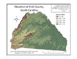
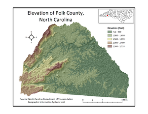
The elevation in the county ranges from just under 800 feet (243.8 m) near the confluence of the Green River
and Broad River to over 3200 feet (975.4 m) on Tryon Peak and Wildcat Spur, the highest peak in the county. Polk County is divided into two physiographic regions
; the Blue Ridge Mountains
in the western third of the county and Piedmont
for the eastern two-thirds. Since it is in a transition zone between the two regions, Polk County is often referred to as being in the foothills.
: Columbus, Cooper's Gap, Green Creek, Saluda, Tryon, and White Oak.
U.S. state
A U.S. state is any one of the 50 federated states of the United States of America that share sovereignty with the federal government. Because of this shared sovereignty, an American is a citizen both of the federal entity and of his or her state of domicile. Four states use the official title of...
of North Carolina
North Carolina
North Carolina is a state located in the southeastern United States. The state borders South Carolina and Georgia to the south, Tennessee to the west and Virginia to the north. North Carolina contains 100 counties. Its capital is Raleigh, and its largest city is Charlotte...
. As of 2010, the population was 20,510. Its county seat
County seat
A county seat is an administrative center, or seat of government, for a county or civil parish. The term is primarily used in the United States....
is Columbus
Columbus, North Carolina
Columbus is a town in Polk County, North Carolina, United States. The population was 992 at the 2000 census. It is the county seat of Polk County.-Geography:Columbus is located at ....
.
History
The county was formed in 1855 from parts of Henderson CountyHenderson County, North Carolina
Henderson County is a county located in the U.S. state of North Carolina. It is part of the Asheville, North Carolina, Metropolitan Statistical Area. As of 2008, the population was 102,367. Its county seat is Hendersonville.- History :...
and Rutherford County
Rutherford County, North Carolina
-Demographics:As of the census of 2000, there were 62,899 people, 25,191 households, and 17,935 families residing in the county. The population density was 112 people per square mile . There were 29,535 housing units at an average density of 52 per square mile...
. It was named for William Polk
William Polk (colonel)
Colonel William Polk was a North Carolina, banker, educational administrator, political leader, renowned Continental officer in the War for American Independence, and survivor of the 1777/1778 encampment at Valley Forge....
, a colonel in the American Revolutionary War
American Revolutionary War
The American Revolutionary War , the American War of Independence, or simply the Revolutionary War, began as a war between the Kingdom of Great Britain and thirteen British colonies in North America, and ended in a global war between several European great powers.The war was the result of the...
.
Law and government
Polk County is a member of the Isothermal Planning and Development CommissionIsothermal Planning and Development Commission
The Isothermal Planning and Development Commission is one of the 17 regional North Carolina Councils of Governments established by the North Carolina General Assembly for the purpose of regional planning and administration. Headquartered in Rutherfordton, North Carolina, it serves Polk,...
regional council of governments.Founded by A. A. H.
Sheila Whitmire is the Registrar of Deeds.
Geography
According to the U.S. Census BureauUnited States Census Bureau
The United States Census Bureau is the government agency that is responsible for the United States Census. It also gathers other national demographic and economic data...
, the county has a total area of 239 square miles (619 km²), of which, 238 square miles (616.4 km²) of it is land and 1 square miles (2.6 km²) of it is water. The total area is 0.31% water.
The county's largest body of water is Lake Adger, located about 5 miles (8 km) north of Columbus
Columbus, North Carolina
Columbus is a town in Polk County, North Carolina, United States. The population was 992 at the 2000 census. It is the county seat of Polk County.-Geography:Columbus is located at ....
.
The elevation in the county ranges from just under 800 feet (243.8 m) near the confluence of the Green River
Green River (North Carolina)
The Green River in North Carolina, United States, is perhaps best known as one of the extreme whitewater kayaking challenges in North America that is run on a regular basis....
and Broad River to over 3200 feet (975.4 m) on Tryon Peak and Wildcat Spur, the highest peak in the county. Polk County is divided into two physiographic regions
Physiographic regions of the world
The physiographic regions of the world are a means of defining the Earth's landforms into distinct regions based upon classic 1916 three-tiered approach defining divisions, provinces, and sections...
; the Blue Ridge Mountains
Blue Ridge Mountains
The Blue Ridge Mountains are a physiographic province of the larger Appalachian Mountains range. This province consists of northern and southern physiographic regions, which divide near the Roanoke River gap. The mountain range is located in the eastern United States, starting at its southern-most...
in the western third of the county and Piedmont
Piedmont (United States)
The Piedmont is a plateau region located in the eastern United States between the Atlantic Coastal Plain and the main Appalachian Mountains, stretching from New Jersey in the north to central Alabama in the south. The Piedmont province is a physiographic province of the larger Appalachian division...
for the eastern two-thirds. Since it is in a transition zone between the two regions, Polk County is often referred to as being in the foothills.
Townships
The county is divided into six townshipsTownship (United States)
A township in the United States is a small geographic area. Townships range in size from 6 to 54 square miles , with being the norm.The term is used in three ways....
: Columbus, Cooper's Gap, Green Creek, Saluda, Tryon, and White Oak.
Adjacent counties
- Rutherford CountyRutherford County, North Carolina-Demographics:As of the census of 2000, there were 62,899 people, 25,191 households, and 17,935 families residing in the county. The population density was 112 people per square mile . There were 29,535 housing units at an average density of 52 per square mile...
, North CarolinaNorth CarolinaNorth Carolina is a state located in the southeastern United States. The state borders South Carolina and Georgia to the south, Tennessee to the west and Virginia to the north. North Carolina contains 100 counties. Its capital is Raleigh, and its largest city is Charlotte...
- north and east - Spartanburg County, South CarolinaSouth CarolinaSouth Carolina is a state in the Deep South of the United States that borders Georgia to the south, North Carolina to the north, and the Atlantic Ocean to the east. Originally part of the Province of Carolina, the Province of South Carolina was one of the 13 colonies that declared independence...
- south-southeast - Greenville CountyGreenville County, South Carolina- External Links :*...
, South CarolinaSouth CarolinaSouth Carolina is a state in the Deep South of the United States that borders Georgia to the south, North Carolina to the north, and the Atlantic Ocean to the east. Originally part of the Province of Carolina, the Province of South Carolina was one of the 13 colonies that declared independence...
- south-southwest - Henderson CountyHenderson County, North CarolinaHenderson County is a county located in the U.S. state of North Carolina. It is part of the Asheville, North Carolina, Metropolitan Statistical Area. As of 2008, the population was 102,367. Its county seat is Hendersonville.- History :...
, North CarolinaNorth CarolinaNorth Carolina is a state located in the southeastern United States. The state borders South Carolina and Georgia to the south, Tennessee to the west and Virginia to the north. North Carolina contains 100 counties. Its capital is Raleigh, and its largest city is Charlotte...
- west
Major Highways
The interchange for I-26 Interstate 26 Interstate 26 is a nominally east–west main route of the Interstate Highway System in the Southeastern United States. I-26 runs from the junction of U.S. Route 11W and U.S. Route 23 in Kingsport, Tennessee, generally southeastward to U.S. Route 17 in Charleston, South Carolina... and the U.S. 74 freeway is located in Columbus. Interstate 26 provides Polk County with easy access to the cities of Johnson City, Tennessee Johnson City, Tennessee Johnson City is a city in Carter, Sullivan, and Washington counties in the U.S. state of Tennessee, with most of the city being in Washington County... and Asheville, North Carolina Asheville, North Carolina Asheville is a city in and the county seat of Buncombe County, North Carolina, United States. It is the largest city in Western North Carolina, and the 11th largest city in North Carolina. The City is home to the United States National Climatic Data Center , which is the world's largest active... to the north, and Spartanburg, South Carolina Spartanburg, South Carolina thgSpartanburg is the largest city in and the county seat of Spartanburg County, South Carolina, United States. It is the second-largest city of the three primary cities in the Upstate region of South Carolina, and is located northwest of Columbia, west of Charlotte, and about northeast of... ; Columbia, South Carolina Columbia, South Carolina Columbia is the state capital and largest city in the U.S. state of South Carolina. The population was 129,272 according to the 2010 census. Columbia is the county seat of Richland County, but a portion of the city extends into neighboring Lexington County. The city is the center of a metropolitan... ; and the port of Charleston, South Carolina Charleston, South Carolina Charleston is the second largest city in the U.S. state of South Carolina. It was made the county seat of Charleston County in 1901 when Charleston County was founded. The city's original name was Charles Towne in 1670, and it moved to its present location from a location on the west bank of the... to the southeast. Interstate 26 junctions with the major Interstates of I-85 and I-40 are within a half-hour and forty minutes, respectively. East on U.S. 74 goes to Charlotte, North Carolina Charlotte, North Carolina Charlotte is the largest city in the U.S. state of North Carolina and the seat of Mecklenburg County. In 2010, Charlotte's population according to the US Census Bureau was 731,424, making it the 17th largest city in the United States based on population. The Charlotte metropolitan area had a 2009... , and eventually to the port of Wilmington, North Carolina Wilmington, North Carolina Wilmington is a port city in and is the county seat of New Hanover County, North Carolina, United States. The population is 106,476 according to the 2010 Census, making it the eighth most populous city in the state of North Carolina... . Proximity to these highways places Polk County in a strategic position for potential business development in the future. Polk County is also served by an additional non-freeway U.S. Highway: U.S. Route 176 U.S. Route 176 U.S. Route 176 is a spur of U.S. Route 76. It currently runs for 229 miles from Goose Creek, South Carolina at U.S. Route 52 to Hendersonville, North Carolina at U.S. Route 25. It passes through the states of South Carolina and North Carolina. It goes through the cities of Spartanburg, South... . This was the primary highway linking Saluda and Tryon to Hendersonville, North Carolina Hendersonville, North Carolina Hendersonville is a city in Henderson County, North Carolina, USA, southeast of Asheville. In 1900, 1,917 persons lived in Hendersonville; in 1910, 2,818; and in 1940, 5,381 people lived here. As of the 2010 census, the city population was 12,223, up fivefold in one century. It is the county... and Spartanburg, S.C. prior to the delayed completion of I-26 in 1976. Two North Carolina routes, N.C. 108 North Carolina Highway 108 North Carolina Highway 108 is a long, two lane highway in North Carolina, USA. It connects U.S. 176 in Tryon to Rutherfordton and passes through both Polk County and Rutherford County. It is a rural country road through eastern Polk County and western Rutherford County, and moderately developed... and N.C. 9, traverse the county as well. N.C. 108 begins in Rutherfordton, North Carolina Rutherfordton, North Carolina Rutherfordton is a town in Rutherford County, North Carolina, United States. The population was 4,131 at the 2000 census. It is the county seat of Rutherford County.-Geography:Rutherfordton is located at .... and travels west through Columbus and ends at U.S. 176 in Tryon. Oriented north-to-south, N.C. 9 connects Black Mountain, North Carolina Black Mountain, North Carolina Black Mountain is a town in Buncombe County, North Carolina, United States. The population was 7,511 at the 2000 census. It is part of the Asheville Metropolitan Statistical Area. The town is named for the Black Mountain range of the Blue Ridge range in the Southern Appalachians.-History:Black... and Lake Lure, North Carolina Lake Lure, North Carolina -History:In 1902, Dr. Lucius B. Morse and his brothers Hiram and Asahel purchased around Chimney Rock for $5,000. They later acquired enough land in the area to bring the total to... to Spartanburg and points southeast via Polk County. N.C. 108 and N.C. 9 intersect at the unincorporated town of Mill Spring. RailPolk County and Saluda are infamous among railroad enthusiasts for the Saluda GradeSaluda Grade Saluda Grade is the steepest standard-gauge mainline railway grade in the United States. Owned by the Norfolk Southern Railway as part of its W Line, the Saluda Grade in Polk County, North Carolina consists of a three-mile section of track that rises over in elevation with a highest official... , the steepest standard-gauge mainline railway grade in the United States. Norfolk Southern suspended freight traffic indefinitely along this route in December 2001. The track remains in place, but are cut near Flat Rock, North Carolina Flat Rock, North Carolina Flat Rock is the name of some places in the U.S. state of North Carolina:*Flat Rock, Henderson County, North Carolina *Flat Rock, Stokes County, North Carolina... and Landrum, South Carolina Landrum, South Carolina Landrum is a city in Spartanburg County, South Carolina, United States. The population was 2,376 at the 2010 census.It was founded in 1880 and incorporated in 1912... . DemographicsAs of the censusCensus A census is the procedure of systematically acquiring and recording information about the members of a given population. It is a regularly occurring and official count of a particular population. The term is used mostly in connection with national population and housing censuses; other common... of 2000, there were 18,324 people, 7,908 households, and 5,337 families residing in the county. The population density Population density Population density is a measurement of population per unit area or unit volume. It is frequently applied to living organisms, and particularly to humans... was 77 people per square mile (30/km²). There were 9,192 housing units at an average density of 39 per square mile (15/km²). The racial makeup of the county was 92.26% White, 5.89% Black or African American, 0.19% Native American, 0.24% Asian, 0.03% Pacific Islander, 0.63% from other races, and 0.76% from two or more races. 3.01% of the population were Hispanic or Latino of any race. There were 7,908 households out of which 23.50% had children under the age of 18 living with them, 56.30% were married couples Marriage Marriage is a social union or legal contract between people that creates kinship. It is an institution in which interpersonal relationships, usually intimate and sexual, are acknowledged in a variety of ways, depending on the culture or subculture in which it is found... living together, 7.90% had a female householder with no husband present, and 32.50% were non-families. 28.90% of all households were made up of individuals and 15.00% had someone living alone who was 65 years of age or older. The average household size was 2.28 and the average family size was 2.78. In the county the population was spread out with 20.10% under the age of 18, 5.80% from 18 to 24, 24.20% from 25 to 44, 26.30% from 45 to 64, and 23.60% who were 65 years of age or older. The median age was 45 years. For every 100 females there were 90.20 males. For every 100 females age 18 and over, there were 87.10 males. The median income for a household in the county was $36,259, and the median income for a family was $45,096. Males had a median income of $29,375 versus $23,070 for females. The per capita income Per capita income Per capita income or income per person is a measure of mean income within an economic aggregate, such as a country or city. It is calculated by taking a measure of all sources of income in the aggregate and dividing it by the total population... for the county was $19,804. 10.10% of the population and 6.40% of families were below the poverty line. 11.70% of those under the age of 18 and 8.80% of those 65 and older were living below the poverty line. Cities and towns
External links
The source of this article is wikipedia, the free encyclopedia. The text of this article is licensed under the GFDL.
|

 U.S. Highway 74
 U.S. Highway 176
 N.C. 9