

Monroe County, Ohio
Encyclopedia
Monroe County is a county located in the state
of Ohio
. As of the 2010 census, the population was 14,642. http://quickfacts.census.gov/qfd/states/39/39111.html Its county seat
is Woodsfield
and is named for James Monroe
, Secretary of State when the county was formed and later President of the United States
.
, the county has a total area of 457 square miles (1,183.6 km²).456 square miles (1,180 km²) of it is land and 2 square miles (5.2 km²) of it (0.42%) is water.
of 2000, there were 15,180 people, 6,021 households, and 4,413 families residing in the county. The population density
was 33 people per square mile (13/km²). There were 7,212 housing units at an average density of 16 per square mile (6/km²). The racial makeup of the county was 98.72% White
, 0.26% Black
or African American
, 0.15% Native American
, 0.07% Asian
, 0.01% Pacific Islander
, 0.11% from other races
, and 0.67% from two or more races. 0.41% of the population were Hispanic
or Latino
of any race.
There were 6,021 households out of which 29.50% had children under the age of 18 living with them, 61.70% were married couples
living together, 8.10% had a female householder with no husband present, and 26.70% were non-families. 24.00% of all households were made up of individuals and 11.50% had someone living alone who was 65 years of age or older. The average household size was 2.50 and the average family size was 2.96.
In the county, the population was spread out with 23.60% under the age of 18, 7.10% from 18 to 24, 25.90% from 25 to 44, 27.20% from 45 to 64, and 16.30% who were 65 years of age or older. The median age was 41 years. For every 100 females there were 97.50 males. For every 100 females age 18 and over, there were 96.10 males.
The median income for a household in the county was $30,467, and the median income for a family was $36,297. Males had a median income of $33,308 versus $19,628 for females. The per capita income
for the county was $15,096. About 11.00% of families and 13.90% of the population were below the poverty line, including 18.30% of those under age 18 and 11.40% of those age 65 or over.
; it also offers a bookmobile
service.
In 2005, the library loaned more than 141,000 items to its 6,000 cardholders. Total holding are over 64,000 volumes with over 140 periodical subscriptions. This library is a member of the SOLO Regional Library System.
:
U.S. state
A U.S. state is any one of the 50 federated states of the United States of America that share sovereignty with the federal government. Because of this shared sovereignty, an American is a citizen both of the federal entity and of his or her state of domicile. Four states use the official title of...
of Ohio
Ohio
Ohio is a Midwestern state in the United States. The 34th largest state by area in the U.S.,it is the 7th‑most populous with over 11.5 million residents, containing several major American cities and seven metropolitan areas with populations of 500,000 or more.The state's capital is Columbus...
. As of the 2010 census, the population was 14,642. http://quickfacts.census.gov/qfd/states/39/39111.html Its county seat
County seat
A county seat is an administrative center, or seat of government, for a county or civil parish. The term is primarily used in the United States....
is Woodsfield
Woodsfield, Ohio
Woodsfield is a village in Monroe County, Ohio, United States. The population was 2,598 at the 2000 census. It is the county seat of Monroe County and houses the Monroe County Courthouse.-Geography:Woodsfield is located at ....
and is named for James Monroe
James Monroe
James Monroe was the fifth President of the United States . Monroe was the last president who was a Founding Father of the United States, and the last president from the Virginia dynasty and the Republican Generation...
, Secretary of State when the county was formed and later President of the United States
President of the United States
The President of the United States of America is the head of state and head of government of the United States. The president leads the executive branch of the federal government and is the commander-in-chief of the United States Armed Forces....
.
Geography
According to the U.S. Census BureauUnited States Census Bureau
The United States Census Bureau is the government agency that is responsible for the United States Census. It also gathers other national demographic and economic data...
, the county has a total area of 457 square miles (1,183.6 km²).456 square miles (1,180 km²) of it is land and 2 square miles (5.2 km²) of it (0.42%) is water.
Adjacent counties
- Belmont CountyBelmont County, OhioBelmont County is a county located in the U.S. state of Ohio. It is part of the Wheeling, West Virginia Metropolitan Statistical Area. As of 2010, the population was 70,400. Its county seat is St. Clairsville...
(north) - Marshall County, West VirginiaMarshall County, West VirginiaAs of the census of 2000, there were 35,519 people, 14,207 households, and 10,101 families residing in the county. The population density was 116 people per square mile . There were 15,814 housing units at an average density of 52 per square mile...
(northeast) - Wetzel County, West VirginiaWetzel County, West VirginiaAs of the census of 2000, there were 17,693 people, 7,164 households, and 5,079 families residing in the county. The population density was 49 people per square mile . There were 8,313 housing units at an average density of 23 per square mile...
(east) - Tyler County, West Virginia (southeast)
- Washington CountyWashington County, OhioWashington County is a county located in the state of Ohio. As of the 2010 census, the population was 61,778. Its county seat is Marietta. The county, the oldest in the state, is named for George Washington. Washington County is included in the Parkersburg-Marietta-Vienna, West Virginia-Ohio...
(south) - Noble CountyNoble County, OhioNoble County is a county located in the state of Ohio. As of the 2010 census, the population was 14,645. Its county seat is Caldwell. Noble County is named for Rep. Warren P. Noble of the Ohio House of Representatives, who was an early settler there.-History:...
(west)
History
Monroe County was formed on January 28, 1813 from portions of Belmont, Guernsey and Washington counties. It was named after James Monroe, a US Secretary of State and later fifth President of the United States.Demographics
As of the censusCensus
A census is the procedure of systematically acquiring and recording information about the members of a given population. It is a regularly occurring and official count of a particular population. The term is used mostly in connection with national population and housing censuses; other common...
of 2000, there were 15,180 people, 6,021 households, and 4,413 families residing in the county. The population density
Population density
Population density is a measurement of population per unit area or unit volume. It is frequently applied to living organisms, and particularly to humans...
was 33 people per square mile (13/km²). There were 7,212 housing units at an average density of 16 per square mile (6/km²). The racial makeup of the county was 98.72% White
Race (United States Census)
Race and ethnicity in the United States Census, as defined by the Federal Office of Management and Budget and the United States Census Bureau, are self-identification data items in which residents choose the race or races with which they most closely identify, and indicate whether or not they are...
, 0.26% Black
Race (United States Census)
Race and ethnicity in the United States Census, as defined by the Federal Office of Management and Budget and the United States Census Bureau, are self-identification data items in which residents choose the race or races with which they most closely identify, and indicate whether or not they are...
or African American
Race (United States Census)
Race and ethnicity in the United States Census, as defined by the Federal Office of Management and Budget and the United States Census Bureau, are self-identification data items in which residents choose the race or races with which they most closely identify, and indicate whether or not they are...
, 0.15% Native American
Race (United States Census)
Race and ethnicity in the United States Census, as defined by the Federal Office of Management and Budget and the United States Census Bureau, are self-identification data items in which residents choose the race or races with which they most closely identify, and indicate whether or not they are...
, 0.07% Asian
Race (United States Census)
Race and ethnicity in the United States Census, as defined by the Federal Office of Management and Budget and the United States Census Bureau, are self-identification data items in which residents choose the race or races with which they most closely identify, and indicate whether or not they are...
, 0.01% Pacific Islander
Race (United States Census)
Race and ethnicity in the United States Census, as defined by the Federal Office of Management and Budget and the United States Census Bureau, are self-identification data items in which residents choose the race or races with which they most closely identify, and indicate whether or not they are...
, 0.11% from other races
Race (United States Census)
Race and ethnicity in the United States Census, as defined by the Federal Office of Management and Budget and the United States Census Bureau, are self-identification data items in which residents choose the race or races with which they most closely identify, and indicate whether or not they are...
, and 0.67% from two or more races. 0.41% of the population were Hispanic
Race (United States Census)
Race and ethnicity in the United States Census, as defined by the Federal Office of Management and Budget and the United States Census Bureau, are self-identification data items in which residents choose the race or races with which they most closely identify, and indicate whether or not they are...
or Latino
Race (United States Census)
Race and ethnicity in the United States Census, as defined by the Federal Office of Management and Budget and the United States Census Bureau, are self-identification data items in which residents choose the race or races with which they most closely identify, and indicate whether or not they are...
of any race.
There were 6,021 households out of which 29.50% had children under the age of 18 living with them, 61.70% were married couples
Marriage
Marriage is a social union or legal contract between people that creates kinship. It is an institution in which interpersonal relationships, usually intimate and sexual, are acknowledged in a variety of ways, depending on the culture or subculture in which it is found...
living together, 8.10% had a female householder with no husband present, and 26.70% were non-families. 24.00% of all households were made up of individuals and 11.50% had someone living alone who was 65 years of age or older. The average household size was 2.50 and the average family size was 2.96.
In the county, the population was spread out with 23.60% under the age of 18, 7.10% from 18 to 24, 25.90% from 25 to 44, 27.20% from 45 to 64, and 16.30% who were 65 years of age or older. The median age was 41 years. For every 100 females there were 97.50 males. For every 100 females age 18 and over, there were 96.10 males.
The median income for a household in the county was $30,467, and the median income for a family was $36,297. Males had a median income of $33,308 versus $19,628 for females. The per capita income
Per capita income
Per capita income or income per person is a measure of mean income within an economic aggregate, such as a country or city. It is calculated by taking a measure of all sources of income in the aggregate and dividing it by the total population...
for the county was $15,096. About 11.00% of families and 13.90% of the population were below the poverty line, including 18.30% of those under age 18 and 11.40% of those age 65 or over.
Government
Monroe County is served by the Monroe County District Library from its administrative offices in Woodsfield, OhioWoodsfield, Ohio
Woodsfield is a village in Monroe County, Ohio, United States. The population was 2,598 at the 2000 census. It is the county seat of Monroe County and houses the Monroe County Courthouse.-Geography:Woodsfield is located at ....
; it also offers a bookmobile
Bookmobile
A bookmobile or mobile library is a large vehicle designed for use as a library. It is designed to hold books on shelves so that when the vehicle is parked the books can be accessed by readers. It usually has enough space for people to sit and read books inside. Mobile libraries are often used to...
service.
In 2005, the library loaned more than 141,000 items to its 6,000 cardholders. Total holding are over 64,000 volumes with over 140 periodical subscriptions. This library is a member of the SOLO Regional Library System.
Communities
Villages
|
Graysville, Ohio Graysville is a village in Monroe County, Ohio, United States. The population was 113 at the 2000 census.Graysville is served by the Monroe County District Library from its administrative offices in Woodsfield, Ohio.-Geography:... Jerusalem, Ohio Jerusalem is a village in Monroe County, Ohio, in the United States. As of the 2000 census, the village population was 152.Jerusalem is served by the Monroe County District Library from its administrative offices in Woodsfield, Ohio.-Geography:... Lewisville, Ohio Lewisville is a village in Monroe County, Ohio, United States. The population was 233 at the 2000 census.Lewisville is served by the Monroe County District Library from its administrative offices in Woodsfield, Ohio.-Geography:... |
Miltonsburg, Ohio Miltonsburg is a village in Monroe County, Ohio, United States. The population was 29 at the 2000 census making Miltonsburg the smallest incorporated place in Ohio.... Stafford, Ohio Stafford is a village in Monroe County, Ohio, United States. The population was 86 at the 2000 census.Stafford is served by the Monroe County District Library from its administrative offices in Woodsfield, Ohio.-Geography:... |
Wilson, Ohio Wilson is a village in Belmont and Monroe counties in the US State of Ohio. It is part of the Wheeling, West Virginia Metropolitan Statistical Area... Woodsfield, Ohio Woodsfield is a village in Monroe County, Ohio, United States. The population was 2,598 at the 2000 census. It is the county seat of Monroe County and houses the Monroe County Courthouse.-Geography:Woodsfield is located at .... |
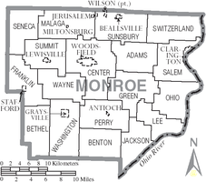
Townships
|
Green Township, Monroe County, Ohio Green Township is one of the eighteen townships of Monroe County, Ohio, United States. The 2000 census found 422 people in the township.-Geography:Located in the center of the county, it borders the following townships:*Adams Township - north... Jackson Township, Monroe County, Ohio Jackson Township is one of the eighteen townships of Monroe County, Ohio, United States. The 2000 census found 473 people in the township.-Geography:Located in the far southern part of the county along the Ohio River, it borders the following townships:... Lee Township, Monroe County, Ohio Lee Township is one of the eighteen townships of Monroe County, Ohio, United States. The 2000 census found 1,122 people in the township.-Geography:Located in the eastern part of the county along the Ohio River, it borders the following townships:... Malaga Township, Monroe County, Ohio Malaga Township is one of the eighteen townships of Monroe County, Ohio, United States. The 2000 census found 979 people in the township, 845 of whom lived in the unincorporated portions of the township.-Geography:... Ohio Township, Monroe County, Ohio Ohio Township is one of the eighteen townships of Monroe County, Ohio, United States. The 2000 census found 1032 people in the township.-Geography:Located in the eastern part of the county along the Ohio River, it borders the following townships:... |
Perry Township, Monroe County, Ohio Perry Township is one of the eighteen townships of Monroe County, Ohio, United States. The 2000 census found 455 people in the township, 366 of whom lived in the unincorporated portions of the township.-Geography:... Salem Township, Monroe County, Ohio Salem Township is one of the eighteen townships of Monroe County, Ohio, United States. The 2000 census found 1,046 people in the township, 602 of whom lived in the unincorporated portions of the township.-Geography:... Seneca Township, Monroe County, Ohio Seneca Township is one of the eighteen townships of Monroe County, Ohio, United States. The 2000 census found 508 people in the township.-Geography:Located in the northwestern corner of the county, it borders the following townships:... Summit Township, Monroe County, Ohio Summit Township is one of the eighteen townships of Monroe County, Ohio, United States. The 2000 census found 714 people in the township, 481 of whom lived in the unincorporated portions of the township.-Geography:... |
Sunsbury Township, Monroe County, Ohio Sunsbury Township is one of the eighteen townships of Monroe County, Ohio, United States. The 2000 census found 1,424 people in the township, 873 of whom lived in the unincorporated portions of the township.-Geography:... Switzerland Township, Monroe County, Ohio Switzerland Township is one of the eighteen townships of Monroe County, Ohio, United States. The 2000 census found 509 people in the township.-Geography:... Washington Township, Monroe County, Ohio Washington Township is one of the eighteen townships of Monroe County, Ohio, United States. The 2000 census found 520 people in the township, 407 of whom lived in the unincorporated portions of the township.-Geography:... Wayne Township, Monroe County, Ohio Wayne Township is one of the eighteen townships of Monroe County, Ohio, United States. The 2000 census found 348 people in the township.-Geography:Located in the western part of the county, it borders the following townships:*Summit Township - north... |
Unincorporated communities
|
Rinard Mills, Ohio Rinard Mills is a small unincorporated village on the Little Muskingum River in southwestern Washington Township, Monroe County, Ohio, United States. It is named after Isaac Rinard, who owned a mill at the village. The village is situated on State Route 26 between Marietta and Woodsfield . The... Sardis, Ohio Sardis is an unincorporated community in southeastern Lee Township, Monroe County, Ohio, United States. Although it is unincorporated, it has a post office with the ZIP code of 43946... Sycamore Valley, Ohio Sycamore Valley is an unincorporated community in northern Bethel Township, Monroe County, Ohio, United States. Although it is unincorporated, it has a post office, with the ZIP code of 43789.-References:... |
Education
Monroe County contains the following schools through the Switzerland of Ohio Local School DistrictSwitzerland of Ohio Local School District
The Switzerland Of Ohio Local School District is a rural school district located in southeastern Ohio that covers all of Monroe County and part of Belmont County and Noble County...
:
- Elementary Schools
- Beallsville Elementary School in Beallsville, OhioBeallsville, OhioBeallsville is a village in Monroe County, Ohio, United States. As of the 2000 census, the village population was 423.The village gained national attention during the Vietnam War by having lost six of its 475 citizens to the war, the worst per-capita loss of life experienced by any place in the...
- Hannibal Elementary School in Hannibal, OhioHannibal, OhioHannibal is a census-designated place in eastern Ohio Township, Monroe County, Ohio, United States. Although it is unincorporated, it has a post office, with the ZIP code of 43931. It lies along State Route 7....
- Sardis Elementary School (Ohio) in Sardis, OhioSardis, OhioSardis is an unincorporated community in southeastern Lee Township, Monroe County, Ohio, United States. Although it is unincorporated, it has a post office with the ZIP code of 43946...
- Skyvue Elementary School in Graysville, OhioGraysville, OhioGraysville is a village in Monroe County, Ohio, United States. The population was 113 at the 2000 census.Graysville is served by the Monroe County District Library from its administrative offices in Woodsfield, Ohio.-Geography:...
- Woodsfield Elementary School in Woodsfield, OhioWoodsfield, OhioWoodsfield is a village in Monroe County, Ohio, United States. The population was 2,598 at the 2000 census. It is the county seat of Monroe County and houses the Monroe County Courthouse.-Geography:Woodsfield is located at ....
- St.Sylvester Central in Woodsfield, OhioWoodsfield, OhioWoodsfield is a village in Monroe County, Ohio, United States. The population was 2,598 at the 2000 census. It is the county seat of Monroe County and houses the Monroe County Courthouse.-Geography:Woodsfield is located at ....
- Beallsville Elementary School in Beallsville, Ohio
- High Schools
- Beallsville High SchoolBeallsville High SchoolBeallsville High School is a public high school in Beallsville, Ohio. It is one of three high schools in the Switzerland of Ohio Local School District. Their nickname is the Blue Devils...
in Beallsville, OhioBeallsville, OhioBeallsville is a village in Monroe County, Ohio, United States. As of the 2000 census, the village population was 423.The village gained national attention during the Vietnam War by having lost six of its 475 citizens to the war, the worst per-capita loss of life experienced by any place in the... - Monroe Central High SchoolMonroe Central High School (Ohio)Monroe Central High School is a public high school in Woodsfield, Ohio. It is one of three high schools in the Switzerland of Ohio Local School District. Their nickname is the Seminoles. The school colors are red, black, white and gold. They are members of the Ohio Valley Athletic Conference and...
in Woodsfield, OhioWoodsfield, OhioWoodsfield is a village in Monroe County, Ohio, United States. The population was 2,598 at the 2000 census. It is the county seat of Monroe County and houses the Monroe County Courthouse.-Geography:Woodsfield is located at .... - River High SchoolRiver High School (Hannibal, Ohio)River High School is a public high school in Hannibal, Ohio. It is one of three high schools in the Switzerland of Ohio Local School District. Their nickname is the Pilots. They are members of the Ohio Valley Athletic Conference...
in Hannibal, OhioHannibal, OhioHannibal is a census-designated place in eastern Ohio Township, Monroe County, Ohio, United States. Although it is unincorporated, it has a post office, with the ZIP code of 43931. It lies along State Route 7....
- Beallsville High School
- Career Center
- Swiss Hills Career Center in Woodsfield, OhioWoodsfield, OhioWoodsfield is a village in Monroe County, Ohio, United States. The population was 2,598 at the 2000 census. It is the county seat of Monroe County and houses the Monroe County Courthouse.-Geography:Woodsfield is located at ....
- Swiss Hills Career Center in Woodsfield, Ohio