
Wyoming County, Pennsylvania
Encyclopedia
Wyoming County is a county
located in the U.S. state
of Pennsylvania
. It was created in 1842 from part of Luzerne County
. Its county seat
is Tunkhannock
.
, the county has a total area of 405 square miles (1,048 km²), of which 397 square miles (1,029 km²) is land and 8 square miles (20 km²) (1.88%) is water.
is a public use airport
located in Wyoming County, one nautical mile (1.85 km) south of the central business district
of Tunkhannock
.
of 2000, there were 28,080 people, 10,762 households, and 7,705 families residing in the county. The population density
was 71 people per square mile (27/km²). There were 12,713 housing units at an average density of 32 per square mile (12/km²). The racial makeup of the county was 98.28% White
, 0.53% Black
or African American
, 0.27% Asian
, 0.17% Native American
, 0.01% Pacific Islander
, 0.15% from other races
, and 0.59% from two or more races. 0.67% of the population were Hispanic
or Latino
of any race. 20.3% were of German, 12.9% Irish
, 11.9% English
, 11.6% Polish, 9.6% American
and 8.1% Italian
ancestry according to Census 2000.
There were 10,762 households out of which 33.20% had children under the age of 18 living with them, 58.10% were married couples
living together, 9.30% had a female householder with no husband present, and 28.40% were non-families. 24.10% of all households were made up of individuals and 9.90% had someone living alone who was 65 years of age or older. The average household size was 2.55 and the average family size was 3.02.
In the county, the population was spread out with 25.50% under the age of 18, 8.00% from 18 to 24, 28.10% from 25 to 44, 25.20% from 45 to 64, and 13.20% who were 65 years of age or older. The median age was 38 years. For every 100 females there were 98.60 males. For every 100 females age 18 and over, there were 95.80 males.
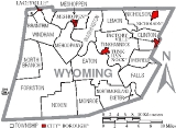
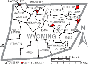 Under Pennsylvania law, there are four types of incorporated municipalities: cities, boroughs, townships, and, in at most two cases, towns. The following boroughs and townships are located in Wyoming County:
County (United States)
In the United States, a county is a geographic subdivision of a state , usually assigned some governmental authority. The term "county" is used in 48 of the 50 states; Louisiana is divided into parishes and Alaska into boroughs. Parishes and boroughs are called "county-equivalents" by the U.S...
located in the U.S. state
U.S. state
A U.S. state is any one of the 50 federated states of the United States of America that share sovereignty with the federal government. Because of this shared sovereignty, an American is a citizen both of the federal entity and of his or her state of domicile. Four states use the official title of...
of Pennsylvania
Pennsylvania
The Commonwealth of Pennsylvania is a U.S. state that is located in the Northeastern and Mid-Atlantic regions of the United States. The state borders Delaware and Maryland to the south, West Virginia to the southwest, Ohio to the west, New York and Ontario, Canada, to the north, and New Jersey to...
. It was created in 1842 from part of Luzerne County
Luzerne County, Pennsylvania
- Demographics :As of the 2010 census, the county was 90.7% White, 3.4% Black or African American, 0.2% Native American, 1.0% Asian, 3.3% were of some other race, and 1.5% were two or more races. 6.7% of the population was of Hispanic or Latino ancestry...
. Its county seat
County seat
A county seat is an administrative center, or seat of government, for a county or civil parish. The term is primarily used in the United States....
is Tunkhannock
Tunkhannock, Pennsylvania
Tunkhannock is a borough in Wyoming County, Pennsylvania, 31 miles northwest of Wilkes-Barre. In the past, lumbering was carried on extensively. The chief industry was tanning and there were spool and tub factories, furnaces and machine shops, stave and planing mills, and witch hazel distilleries....
.
Geography
According to the U.S. Census BureauUnited States Census Bureau
The United States Census Bureau is the government agency that is responsible for the United States Census. It also gathers other national demographic and economic data...
, the county has a total area of 405 square miles (1,048 km²), of which 397 square miles (1,029 km²) is land and 8 square miles (20 km²) (1.88%) is water.
Adjacent counties
- Susquehanna CountySusquehanna County, Pennsylvania-Demographics:As of the census of 2000, there were 42,238 people, 16,529 households, and 11,785 families residing in the county. The population density was 51 people per square mile . There were 21,829 housing units at an average density of 26 per square mile...
(north) - Lackawanna CountyLackawanna County, PennsylvaniaAs of the census of 2000, there were 213,295 people, 86,218 households, and 55,783 families residing in the county. The population density was 465 people per square mile . There were 95,362 housing units at an average density of 208 per square mile...
(east) - Luzerne CountyLuzerne County, Pennsylvania- Demographics :As of the 2010 census, the county was 90.7% White, 3.4% Black or African American, 0.2% Native American, 1.0% Asian, 3.3% were of some other race, and 1.5% were two or more races. 6.7% of the population was of Hispanic or Latino ancestry...
(south) - Sullivan CountySullivan County, PennsylvaniaSullivan County is a county located in the U.S. state of Pennsylvania. As of 2010, the population is 6,428. Sullivan County was created on March 15, 1847, from part of Lycoming County and named for Charles Sullivan, leader of the Pennsylvania Senate...
(west) - Bradford CountyBradford County, Pennsylvania-Demographics:As of the census of 2000, there were 62,761 people, 24,453 households, and 17,312 families residing in the county. The population density was 54 people per square mile . There were 28,664 housing units at an average density of 25 per square mile...
(northwest)
Transportation
Skyhaven AirportSkyhaven Airport (Pennsylvania)
Skyhaven Airport is a public use airport located one nautical mile south of the central business district of Tunkhannock, a borough in Wyoming County, Pennsylvania, United States.- Facilities and aircraft :...
is a public use airport
Airport
An airport is a location where aircraft such as fixed-wing aircraft, helicopters, and blimps take off and land. Aircraft may be stored or maintained at an airport...
located in Wyoming County, one nautical mile (1.85 km) south of the central business district
Central business district
A central business district is the commercial and often geographic heart of a city. In North America this part of a city is commonly referred to as "downtown" or "city center"...
of Tunkhannock
Tunkhannock, Pennsylvania
Tunkhannock is a borough in Wyoming County, Pennsylvania, 31 miles northwest of Wilkes-Barre. In the past, lumbering was carried on extensively. The chief industry was tanning and there were spool and tub factories, furnaces and machine shops, stave and planing mills, and witch hazel distilleries....
.
Demographics
As of the censusCensus
A census is the procedure of systematically acquiring and recording information about the members of a given population. It is a regularly occurring and official count of a particular population. The term is used mostly in connection with national population and housing censuses; other common...
of 2000, there were 28,080 people, 10,762 households, and 7,705 families residing in the county. The population density
Population density
Population density is a measurement of population per unit area or unit volume. It is frequently applied to living organisms, and particularly to humans...
was 71 people per square mile (27/km²). There were 12,713 housing units at an average density of 32 per square mile (12/km²). The racial makeup of the county was 98.28% White
Race (United States Census)
Race and ethnicity in the United States Census, as defined by the Federal Office of Management and Budget and the United States Census Bureau, are self-identification data items in which residents choose the race or races with which they most closely identify, and indicate whether or not they are...
, 0.53% Black
Race (United States Census)
Race and ethnicity in the United States Census, as defined by the Federal Office of Management and Budget and the United States Census Bureau, are self-identification data items in which residents choose the race or races with which they most closely identify, and indicate whether or not they are...
or African American
Race (United States Census)
Race and ethnicity in the United States Census, as defined by the Federal Office of Management and Budget and the United States Census Bureau, are self-identification data items in which residents choose the race or races with which they most closely identify, and indicate whether or not they are...
, 0.27% Asian
Race (United States Census)
Race and ethnicity in the United States Census, as defined by the Federal Office of Management and Budget and the United States Census Bureau, are self-identification data items in which residents choose the race or races with which they most closely identify, and indicate whether or not they are...
, 0.17% Native American
Race (United States Census)
Race and ethnicity in the United States Census, as defined by the Federal Office of Management and Budget and the United States Census Bureau, are self-identification data items in which residents choose the race or races with which they most closely identify, and indicate whether or not they are...
, 0.01% Pacific Islander
Race (United States Census)
Race and ethnicity in the United States Census, as defined by the Federal Office of Management and Budget and the United States Census Bureau, are self-identification data items in which residents choose the race or races with which they most closely identify, and indicate whether or not they are...
, 0.15% from other races
Race (United States Census)
Race and ethnicity in the United States Census, as defined by the Federal Office of Management and Budget and the United States Census Bureau, are self-identification data items in which residents choose the race or races with which they most closely identify, and indicate whether or not they are...
, and 0.59% from two or more races. 0.67% of the population were Hispanic
Race (United States Census)
Race and ethnicity in the United States Census, as defined by the Federal Office of Management and Budget and the United States Census Bureau, are self-identification data items in which residents choose the race or races with which they most closely identify, and indicate whether or not they are...
or Latino
Race (United States Census)
Race and ethnicity in the United States Census, as defined by the Federal Office of Management and Budget and the United States Census Bureau, are self-identification data items in which residents choose the race or races with which they most closely identify, and indicate whether or not they are...
of any race. 20.3% were of German, 12.9% Irish
Irish people
The Irish people are an ethnic group who originate in Ireland, an island in northwestern Europe. Ireland has been populated for around 9,000 years , with the Irish people's earliest ancestors recorded having legends of being descended from groups such as the Nemedians, Fomorians, Fir Bolg, Tuatha...
, 11.9% English
English people
The English are a nation and ethnic group native to England, who speak English. The English identity is of early mediaeval origin, when they were known in Old English as the Anglecynn. England is now a country of the United Kingdom, and the majority of English people in England are British Citizens...
, 11.6% Polish, 9.6% American
United States
The United States of America is a federal constitutional republic comprising fifty states and a federal district...
and 8.1% Italian
Italian people
The Italian people are an ethnic group that share a common Italian culture, ancestry and speak the Italian language as a mother tongue. Within Italy, Italians are defined by citizenship, regardless of ancestry or country of residence , and are distinguished from people...
ancestry according to Census 2000.
There were 10,762 households out of which 33.20% had children under the age of 18 living with them, 58.10% were married couples
Marriage
Marriage is a social union or legal contract between people that creates kinship. It is an institution in which interpersonal relationships, usually intimate and sexual, are acknowledged in a variety of ways, depending on the culture or subculture in which it is found...
living together, 9.30% had a female householder with no husband present, and 28.40% were non-families. 24.10% of all households were made up of individuals and 9.90% had someone living alone who was 65 years of age or older. The average household size was 2.55 and the average family size was 3.02.
In the county, the population was spread out with 25.50% under the age of 18, 8.00% from 18 to 24, 28.10% from 25 to 44, 25.20% from 45 to 64, and 13.20% who were 65 years of age or older. The median age was 38 years. For every 100 females there were 98.60 males. For every 100 females age 18 and over, there were 95.80 males.
Politics
As of May 2007, there are 19,609 registered voters in Wyoming County http://www.dos.state.pa.us/elections/lib/elections/055_voter_registration_statistics/2007munprimaryvoterregistotalscounty_for_website.pdf.- DemocraticDemocratic Party (United States)The Democratic Party is one of two major contemporary political parties in the United States, along with the Republican Party. The party's socially liberal and progressive platform is largely considered center-left in the U.S. political spectrum. The party has the lengthiest record of continuous...
: 6,433 (32.81%) - RepublicanRepublican Party (United States)The Republican Party is one of the two major contemporary political parties in the United States, along with the Democratic Party. Founded by anti-slavery expansion activists in 1854, it is often called the GOP . The party's platform generally reflects American conservatism in the U.S...
: 11,109 (56.65%) - Other Parties: 2,067 (10.54%)
Municipalities
Boroughs
- FactoryvilleFactoryville, PennsylvaniaFactoryville is a borough in Wyoming County, Pennsylvania, United States. The population was 1,144 at the 2000 census.-Geography:Factoryville is located at ....
- LaceyvilleLaceyville, PennsylvaniaLaceyville is a borough in Wyoming County, Pennsylvania, United States. The population was 396 at the 2000 census.-Geography:Laceyville is located at ....
- MeshoppenMeshoppen, PennsylvaniaMeshoppen is a borough in Wyoming County, Pennsylvania, United States. The population was 459 at the 2000 census.-Geography:Meshoppen is located at ....
- NicholsonNicholson, PennsylvaniaNicholson is a borough in Wyoming County, Pennsylvania, United States. The population was 713 at the 2000 census.-Geography:Nicholson is located at ....
- TunkhannockTunkhannock, PennsylvaniaTunkhannock is a borough in Wyoming County, Pennsylvania, 31 miles northwest of Wilkes-Barre. In the past, lumbering was carried on extensively. The chief industry was tanning and there were spool and tub factories, furnaces and machine shops, stave and planing mills, and witch hazel distilleries....
Townships
|
Monroe Township, Wyoming County, Pennsylvania Monroe Township is a township in Wyoming County, Pennsylvania, United States. The population was 1,836 at the 2000 census.-Geography:According to the United States Census Bureau, the township has a total area of 20.9 square miles , of which, 20.7 square miles of it is land and... Nicholson Township, Wyoming County, Pennsylvania Nicholson Township is a township in Wyoming County, Pennsylvania, United States. The population was 1,361 at the 2000 census.-Geography:According to the United States Census Bureau, the township has a total area of 22.8 square miles , of which, 22.5 square miles of it is land and... Tunkhannock Township, Wyoming County, Pennsylvania Tunkhannock Township is a township in Wyoming County, Pennsylvania, United States. The population was 4,298 at the 2000 census.-Geography:According to the United States Census Bureau, the township has a total area of 32.0 square miles , of which, 31.1 square miles of it is land and... Washington Township, Wyoming County, Pennsylvania Washington Township is a township in Wyoming County, Pennsylvania, United States. The population was 1,306 at the 2000 census.-Geography:According to the United States Census Bureau, the township has a total area of 19.3 square miles , of which, 18.7 square miles of it is land and... Windham Township, Wyoming County, Pennsylvania Windham Township is a township in Wyoming County, Pennsylvania, in the United States. As of the 2000 census, the township population was 828.-Geography:... |
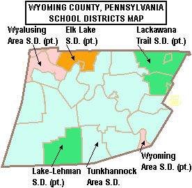
Public School Districts
- Elk Lake School DistrictElk Lake School DistrictElk Lake School District is a small, rural, K-12 public school district located on State Route 3019 in Dimock, Susquehanna County, Pennsylvania. It covers the borough of Hop Bottom along with residents in: Auburn Township, Middletown Township, Rush Township, Dimock Township, and Springville...
(also in Susquehanna County) - Lackawanna Trail School DistrictLackawanna Trail School DistrictThe Lackawanna Trail School District is a Pennsylvania school district founded in 1953 that covers two counties, Lackawanna County and Wyoming County.L.T.S.D. is also home of the LIONS!...
(also in Lackawanna County) - Lake-Lehman School DistrictLake-Lehman School DistrictThe Lake-Lehman School District is a small public school district located partly in Luzerne County and partly in Wyoming County. The school's namesakes are the borough of Lake and Lehman Township. It also serves Ross Township, Jackson Township, and Lake Township as well as Noxen Township in Wyoming...
(also in Luzerne County) - Tunkhannock Area School DistrictTunkhannock Area School DistrictTunkhannock Area School District is a school district serving most of Wyoming County in northeast Pennsylvania in the United States. The district operates six schools - Roslund Elementary in Tunkhannock, Mehoopany Elementary in Mehoopany Township, Mill City Elementary in Dalton, PA, Evans Falls...
- Wyalusing Area School DistrictWyalusing Area School DistrictThe Wyalusing Area School District spans portions of two counties. In southeastern Bradford County it covers the Boroughs of New Albany and Wyalusing and Albany Township, Herrick Township, Overton Township, Stevens Township, Terry Township, Tuscarora Township, Wilmot Township and Wyalusing Township...
(also in Bradford County) - Wyoming Area School DistrictWyoming Area School DistrictThe Wyoming Area School District is a midsized, public school district located in northeastern Luzerne County, Pennsylvania midway between Wilkes-Barre and Scranton . The district is composed of six municipalities: West Pittston, Exeter, Wyoming, West Wyoming, Harding and Falls Township, covering...
(also in Luzerne County)
See also
- List of municipal authorities in Wyoming County, Pennsylvania
- National Register of Historic Places listings in Wyoming County, PennsylvaniaNational Register of Historic Places listings in Wyoming County, PennsylvaniaThis is a list of the National Register of Historic Places listings in Wyoming County, Pennsylvania.This is intended to be a complete list of the properties and districts on the National Register of Historic Places in Wyoming County, Pennsylvania, United States...