

Dade County, Georgia
Encyclopedia
Dade County is a county located in the U.S. state
of Georgia
. As of 2000, the population is 15,154. The 2007 Census Estimate shows a population of 16,098. The county seat
is Trenton
.
Dade County is part of the Chattanooga
, TN
–GA Metropolitan Statistical Area
.
of 2000, there were 15,154 people, 5,633 households, and 4,264 families residing in the county. The population density
was 87 people per square mile (34/km²). There were 6,224 housing units at an average density of 36 per square mile (14/km²). The racial makeup of the county was 97.51% White
, 0.63% Black
or African American
, 0.49% Native American
, 0.38% Asian
, 0.03% Pacific Islander
, 0.20% from other races
, and 0.76% from two or more races. 0.90% of the population were Hispanic
or Latino
of any race.
There were 5,633 households out of which 33.30% had children under the age of 18 living with them, 62.70% were married couples
living together, 9.50% had a female householder with no husband present, and 24.30% were non-families. 21.70% of all households were made up of individuals and 8.20% had someone living alone who was 65 years of age or older. The average household size was 2.55 and the average family size was 2.97.
In the county the population was spread out with 23.80% under the age of 18, 11.80% from 18 to 24, 27.80% from 25 to 44, 24.50% from 45 to 64, and 12.00% who were 65 years of age or older. The median age was 36 years. For every 100 females there were 96.00 males. For every 100 females age 18 and over, there were 91.80 males.
The median income for a household in the county was $35,259, and the median income for a family was $39,481. Males had a median income of $31,534 versus $21,753 for females. The per capita income
for the county was $16,127. About 7.50% of families and 9.70% of the population were below the poverty line, including 7.40% of those under age 18 and 12.50% of those age 65 or over.
Indians in December, 1835.
The first settlers of Dade County won the land in Georgia's land lottery and came to work in coke and coal mines.
Georgia did not have a road connecting to Dade County until the purchase of Cloudland Canyon in 1939. The county could only be accessed through Alabama and Tennessee until then.
Covenant College
, founded in 1955 in California, needed to expand into new facilities after just one year. Several professors helped Covenant move to St. Louis, Missouri where it grew for eight years and in 1964 the institution outgrew its facilities and moved to Lookout Mountain
.
Dade County had a short-lived state secessionist movement during the civil war. Dade Countians wanted to secede from the Union but the State of Georgia was cautious. Legend has is that in 1860, the people of Dade County were so impatient on their state to secede from the Union, they simply seceded by themselves. On July 4, 1945, a telegram from President Harry S. Truman
was read at a celebration marking the county's rejoining the Union. Historians believe, however, that Dade County seceded with the State of Georgia and reentered the Union with it.
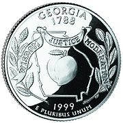 Shortly after the Georgia State Quarter was released, Dade County gained attention over an apparent mistake in the quarter. The outline of the state of Georgia on the quarter appears to have accidentally left out Dade County, which is in the extreme northwestern part of the state. It has also been suggested that the exclusion was intentional, in reference to the local legend of Dade County's secession from Georgia.
on the Tennessee River
, which is created by the Nickajack Dam
, part of the Tennessee Valley Authority
. The water source has been desired by Atlanta, Georgia
to supplement water drained from Lake Lanier
and Lake Allatoona
. Georgia lawmakers wished to change the Tennessee-Georgia state line because it is based upon a flawed 1818 survey that mistakenly placed Georgia's northern line just short of the Tennessee River.
U.S. state
A U.S. state is any one of the 50 federated states of the United States of America that share sovereignty with the federal government. Because of this shared sovereignty, an American is a citizen both of the federal entity and of his or her state of domicile. Four states use the official title of...
of Georgia
Georgia (U.S. state)
Georgia is a state located in the southeastern United States. It was established in 1732, the last of the original Thirteen Colonies. The state is named after King George II of Great Britain. Georgia was the fourth state to ratify the United States Constitution, on January 2, 1788...
. As of 2000, the population is 15,154. The 2007 Census Estimate shows a population of 16,098. The county seat
County seat
A county seat is an administrative center, or seat of government, for a county or civil parish. The term is primarily used in the United States....
is Trenton
Trenton, Georgia
Trenton is a city in Dade County, Georgia, United States. The population was 1,942 at the 2000 census. It is the only incorporated municipality in the county, and as such it serves as the county seat....
.
Dade County is part of the Chattanooga
Chattanooga, Tennessee
Chattanooga is the fourth-largest city in the US state of Tennessee , with a population of 169,887. It is the seat of Hamilton County...
, TN
Tennessee
Tennessee is a U.S. state located in the Southeastern United States. It has a population of 6,346,105, making it the nation's 17th-largest state by population, and covers , making it the 36th-largest by total land area...
–GA Metropolitan Statistical Area
Chattanooga metropolitan area
The Chattanooga Metropolitan Statistical Area, as defined by the United States Census Bureau, is an area consisting of six counties – three in southeast Tennessee and three in northwest Georgia – anchored by the city of Chattanooga...
.
Geography
According to the 2000 census, the county has a total area of 174.16 square miles (451.1 km²), of which 173.98 square miles (450.6 km²) (or 99.90%) is land and 0.18 square mile (0.4661978598 km²) (or 0.10%) is water.Major highways
 Interstate 24Interstate 24Interstate 24 is an Interstate Highway in the Midwestern and Southeastern United States. It runs diagonally from Interstate 57 to Chattanooga, Tennessee, at Interstate 75....
 Interstate 59Interstate 59Interstate 59 is an Interstate Highway in the southern United States. Its southern terminus is near Slidell, Louisiana, a suburb of New Orleans, at an intersection with Interstate 10 and Interstate 12, its northern terminus is at Wildwood, Georgia, at an intersection with Interstate 24.The road's...
 U.S. Route 11U.S. Route 11U.S. Route 11 is a north–south United States highway extending 1,645 miles across the eastern United States. The southern terminus of the route is at U.S. Route 90 in the Bayou Sauvage National Wildlife Refuge in eastern New Orleans, Louisiana. The northern terminus is at the United...
 State Route 58
 State Route 136
 State Route 157
 State Route 189
 State Route 299
 State Route 301
Adjacent counties
- Marion CountyMarion County, TennesseeMarion County is a county located in the U.S. state of Tennessee. As of 2000, the population was 27,776. Its county seat is Jasper.Marion County is part of the Chattanooga, TN–GA Metropolitan Statistical Area.-Geography:According to the U.S...
, TennesseeTennesseeTennessee is a U.S. state located in the Southeastern United States. It has a population of 6,346,105, making it the nation's 17th-largest state by population, and covers , making it the 36th-largest by total land area...
(north) - Hamilton CountyHamilton County, TennesseeHamilton County is a county located in the U.S. state of Tennessee. It was named for Alexander Hamilton, the first Secretary of the Treasury. The 2005 Census Estimate placed the population at 310,935 . Its county seat is Chattanooga....
, TennesseeTennesseeTennessee is a U.S. state located in the Southeastern United States. It has a population of 6,346,105, making it the nation's 17th-largest state by population, and covers , making it the 36th-largest by total land area...
(northeast) - Walker CountyWalker County, GeorgiaWalker County is a county located in the U.S. state of Georgia. It was created on December 18, 1833 from land formerly belonging to the Cherokee Indian Nation. As of 2000, the population was 61,053. The 2007 Census Estimate shows a population of 64,554...
(southeast) - DeKalb CountyDeKalb County, AlabamaAs of the 2010 Census DeKalb County had a population of 71,109. The median age was 37.5. The racial and ethnic makeup of the population was 81.6% non-Hispanic white, 1.5% African American, 1.4% Native American, 0.3% Asian, 0.2% Pacific Islander , 9.9% from some other race, 2.2% reporting two or...
, AlabamaAlabamaAlabama is a state located in the southeastern region of the United States. It is bordered by Tennessee to the north, Georgia to the east, Florida and the Gulf of Mexico to the south, and Mississippi to the west. Alabama ranks 30th in total land area and ranks second in the size of its inland...
(southwest) - Jackson CountyJackson County, AlabamaJackson County is a county of the U.S. state of Alabama. Its name is in honor of Andrew Jackson, general in the United States Army and President of the United States of America. As of 2010, the population was 53,227. The county seat is Scottsboro. Jackson County is a prohibition or dry county,...
, AlabamaAlabamaAlabama is a state located in the southeastern region of the United States. It is bordered by Tennessee to the north, Georgia to the east, Florida and the Gulf of Mexico to the south, and Mississippi to the west. Alabama ranks 30th in total land area and ranks second in the size of its inland...
(west)
Demographics
As of the censusCensus
A census is the procedure of systematically acquiring and recording information about the members of a given population. It is a regularly occurring and official count of a particular population. The term is used mostly in connection with national population and housing censuses; other common...
of 2000, there were 15,154 people, 5,633 households, and 4,264 families residing in the county. The population density
Population density
Population density is a measurement of population per unit area or unit volume. It is frequently applied to living organisms, and particularly to humans...
was 87 people per square mile (34/km²). There were 6,224 housing units at an average density of 36 per square mile (14/km²). The racial makeup of the county was 97.51% White
Race (United States Census)
Race and ethnicity in the United States Census, as defined by the Federal Office of Management and Budget and the United States Census Bureau, are self-identification data items in which residents choose the race or races with which they most closely identify, and indicate whether or not they are...
, 0.63% Black
Race (United States Census)
Race and ethnicity in the United States Census, as defined by the Federal Office of Management and Budget and the United States Census Bureau, are self-identification data items in which residents choose the race or races with which they most closely identify, and indicate whether or not they are...
or African American
Race (United States Census)
Race and ethnicity in the United States Census, as defined by the Federal Office of Management and Budget and the United States Census Bureau, are self-identification data items in which residents choose the race or races with which they most closely identify, and indicate whether or not they are...
, 0.49% Native American
Race (United States Census)
Race and ethnicity in the United States Census, as defined by the Federal Office of Management and Budget and the United States Census Bureau, are self-identification data items in which residents choose the race or races with which they most closely identify, and indicate whether or not they are...
, 0.38% Asian
Race (United States Census)
Race and ethnicity in the United States Census, as defined by the Federal Office of Management and Budget and the United States Census Bureau, are self-identification data items in which residents choose the race or races with which they most closely identify, and indicate whether or not they are...
, 0.03% Pacific Islander
Race (United States Census)
Race and ethnicity in the United States Census, as defined by the Federal Office of Management and Budget and the United States Census Bureau, are self-identification data items in which residents choose the race or races with which they most closely identify, and indicate whether or not they are...
, 0.20% from other races
Race (United States Census)
Race and ethnicity in the United States Census, as defined by the Federal Office of Management and Budget and the United States Census Bureau, are self-identification data items in which residents choose the race or races with which they most closely identify, and indicate whether or not they are...
, and 0.76% from two or more races. 0.90% of the population were Hispanic
Race (United States Census)
Race and ethnicity in the United States Census, as defined by the Federal Office of Management and Budget and the United States Census Bureau, are self-identification data items in which residents choose the race or races with which they most closely identify, and indicate whether or not they are...
or Latino
Race (United States Census)
Race and ethnicity in the United States Census, as defined by the Federal Office of Management and Budget and the United States Census Bureau, are self-identification data items in which residents choose the race or races with which they most closely identify, and indicate whether or not they are...
of any race.
There were 5,633 households out of which 33.30% had children under the age of 18 living with them, 62.70% were married couples
Marriage
Marriage is a social union or legal contract between people that creates kinship. It is an institution in which interpersonal relationships, usually intimate and sexual, are acknowledged in a variety of ways, depending on the culture or subculture in which it is found...
living together, 9.50% had a female householder with no husband present, and 24.30% were non-families. 21.70% of all households were made up of individuals and 8.20% had someone living alone who was 65 years of age or older. The average household size was 2.55 and the average family size was 2.97.
In the county the population was spread out with 23.80% under the age of 18, 11.80% from 18 to 24, 27.80% from 25 to 44, 24.50% from 45 to 64, and 12.00% who were 65 years of age or older. The median age was 36 years. For every 100 females there were 96.00 males. For every 100 females age 18 and over, there were 91.80 males.
The median income for a household in the county was $35,259, and the median income for a family was $39,481. Males had a median income of $31,534 versus $21,753 for females. The per capita income
Per capita income
Per capita income or income per person is a measure of mean income within an economic aggregate, such as a country or city. It is calculated by taking a measure of all sources of income in the aggregate and dividing it by the total population...
for the county was $16,127. About 7.50% of families and 9.70% of the population were below the poverty line, including 7.40% of those under age 18 and 12.50% of those age 65 or over.
History
Dade County was established in 1837 and was named for Major Francis Langhorne Dade, who was killed in the Dade Massacre by SeminoleSeminole
The Seminole are a Native American people originally of Florida, who now reside primarily in that state and Oklahoma. The Seminole nation emerged in a process of ethnogenesis out of groups of Native Americans, most significantly Creeks from what is now Georgia and Alabama, who settled in Florida in...
Indians in December, 1835.
The first settlers of Dade County won the land in Georgia's land lottery and came to work in coke and coal mines.
Georgia did not have a road connecting to Dade County until the purchase of Cloudland Canyon in 1939. The county could only be accessed through Alabama and Tennessee until then.
Covenant College
Covenant College
Covenant College is a Christian liberal arts college in Lookout Mountain, Georgia, United States.-History:Founded in 1955 in Pasadena, California, Covenant College and Theological Seminary moved its campus to St. Louis, Missouri the following year, and, in 1965, separated from the seminary, moving...
, founded in 1955 in California, needed to expand into new facilities after just one year. Several professors helped Covenant move to St. Louis, Missouri where it grew for eight years and in 1964 the institution outgrew its facilities and moved to Lookout Mountain
Lookout Mountain
thumb|right|See seven statesLookout Mountain is located at the northwest corner of the U.S. state of Georgia, the northeast corner of Alabama, and along the southern border of Tennessee at Chattanooga. Lookout Mountain, along with Sand Mountain to the northwest, makes up a large portion of the...
.
Dade County had a short-lived state secessionist movement during the civil war. Dade Countians wanted to secede from the Union but the State of Georgia was cautious. Legend has is that in 1860, the people of Dade County were so impatient on their state to secede from the Union, they simply seceded by themselves. On July 4, 1945, a telegram from President Harry S. Truman
Harry S. Truman
Harry S. Truman was the 33rd President of the United States . As President Franklin D. Roosevelt's third vice president and the 34th Vice President of the United States , he succeeded to the presidency on April 12, 1945, when President Roosevelt died less than three months after beginning his...
was read at a celebration marking the county's rejoining the Union. Historians believe, however, that Dade County seceded with the State of Georgia and reentered the Union with it.
Quarter Controversy
Georgia water supply
Dade County lies just south of Nickajack LakeNickajack Lake
Nickajack Lake is the reservoir created by Nickajack Dam as part of the Tennessee Valley Authority. The lake stretches from Nickajack Dam to Chickamauga Dam, and runs along the shores of Chattanooga, TN...
on the Tennessee River
Tennessee River
The Tennessee River is the largest tributary of the Ohio River. It is approximately 652 miles long and is located in the southeastern United States in the Tennessee Valley. The river was once popularly known as the Cherokee River, among other names...
, which is created by the Nickajack Dam
Nickajack Dam
Nickajack Dam is a hydroelectric dam in Marion County in the U.S. state of Tennessee. It is one of nine dams on the Tennessee River owned and operated by the Tennessee Valley Authority, which built the dam in the mid-1960s to replace the outdated Hales Bar Dam upstream. The dam impounds the ...
, part of the Tennessee Valley Authority
Tennessee Valley Authority
The Tennessee Valley Authority is a federally owned corporation in the United States created by congressional charter in May 1933 to provide navigation, flood control, electricity generation, fertilizer manufacturing, and economic development in the Tennessee Valley, a region particularly affected...
. The water source has been desired by Atlanta, Georgia
Atlanta, Georgia
Atlanta is the capital and most populous city in the U.S. state of Georgia. According to the 2010 census, Atlanta's population is 420,003. Atlanta is the cultural and economic center of the Atlanta metropolitan area, which is home to 5,268,860 people and is the ninth largest metropolitan area in...
to supplement water drained from Lake Lanier
Lake Lanier
Lake Lanier is a reservoir in the northern portion of the U.S. state of Georgia. It was created by the completion of Buford Dam on the Chattahoochee River in 1956, and is also fed by the waters of the Chestatee River. The lake encompasses of water, and of shoreline at normal level, a "full...
and Lake Allatoona
Lake Allatoona
Lake Allatoona is a U.S. Army Corps of Engineers reservoir in Georgia, located in northwestern metro Atlanta. The lake is mostly in southwestern Cherokee County, but a significant part is in southeastern Bartow County, and a small part in Cobb County near Acworth. Cartersville is the nearest...
. Georgia lawmakers wished to change the Tennessee-Georgia state line because it is based upon a flawed 1818 survey that mistakenly placed Georgia's northern line just short of the Tennessee River.
Cities and towns
- New England
- Rising FawnRising Fawn, GeorgiaRising Fawn is a small unincorporated community in the southern part of Dade County, Georgia, United States. It is part of the Chattanooga, TN–GA Metropolitan Statistical Area. It is also the location of Cloudland Canyon State Park.-Notable residents:...
- TrentonTrenton, GeorgiaTrenton is a city in Dade County, Georgia, United States. The population was 1,942 at the 2000 census. It is the only incorporated municipality in the county, and as such it serves as the county seat....
- WildwoodWildwood, GeorgiaWildwood is a small unincorporated community located in the northeastern corner of Dade County, Georgia, United States. It is close to the Tennessee state line and the Chattanooga city limits, and is considered part of the Chattanooga metropolitan area...
See also
- National Register of Historic Places listings in Dade County, Georgia
- Northwest Georgia Joint Development AuthorityNorthwest Georgia Joint Development AuthorityThe Northwest Georgia Joint Development Authority is a joint development authority that serves Catoosa County, Chattooga County, Dade County, and Walker County in the U.S. state of Georgia....