

Ashtabula County, Ohio
Encyclopedia
Ashtabula County is the northeasternmost county in the state
of Ohio
. As of 2010, the population was 101,497, http://quickfacts.census.gov/qfd/states/39/39007.html its county seat
is Jefferson
. The county is named for a Native American
word meaning "river of many fish".
The county is probably best known for having seventeen covered bridges within the county limits. Grapes are a popular crop and there are several wineries in the region owing to the favorable microclimate
created by the nearby lake. During the winter, Ashtabula County receives frequent lake effect snow
and is part of the Southeastern Lake Erie Snowbelt
.
The Ashtabula Micropolitan Statistical Area includes all of Ashtabula County.
, the county has a total area of 1368 square miles (3,543.1 km²). 702 square miles (1,818.2 km²) is land and 666 square miles (1,724.9 km²) (48.67%) is water.
of 2000, there were 102,728 people, 39,397 households, and 27,774 families residing in the county. The population density
was 146 people per square mile (56/km²). There were 43,792 housing units at an average density of 62 per square mile (24/km²). The racial makeup of the county was 94.07% White
, 3.16% Black
or African American
, 0.19% Native American
, 0.34% Asian
, 0.02% Pacific Islander
, 0.85% from other races
, and 1.36% from two or more races. 2.23% of the population were Hispanic
or Latino
of any race. 19.3% were of German
, 11.6% Italian
, 10.6% English
, 10.5% Irish
and 10.3% American
ancestry according to Census 2000. 95.2% spoke English
and 2.4% Spanish
as their first language.
There were 39,397 households out of which 32.40% had children under the age of 18 living with them, 54.80% were married couples
living together, 11.40% had a female householder with no husband present, and 29.50% were non-families. 24.80% of all households were made up of individuals and 10.70% had someone living alone who was 65 years of age or older. The average household size was 2.56 and the average family size was 3.05.
In the county the population was spread out with 26.20% under the age of 18, 7.60% from 18 to 24, 28.00% from 25 to 44, 23.60% from 45 to 64, and 14.70% who were 65 years of age or older. The median age was 38 years. For every 100 females there were 95.10 males. For every 100 females age 18 and over, there were 92.10 males.
The median income for a household in the county was $35,607, and the median income for a family was $42,449. Males had a median income of $33,105 versus $22,624 for females. The per capita income
for the county was $16,814. About 9.20% of families and 12.10% of the population were below the poverty line, including 17.10% of those under age 18 and 8.60% of those age 65 or over.
s, and an annual FinnFest USA celebration is held in Ashtabula.http://www.finnfestusa2007.com/
Ashtabula County has a large number of covered bridge
s. See List of Ashtabula County covered bridges.
U.S. state
A U.S. state is any one of the 50 federated states of the United States of America that share sovereignty with the federal government. Because of this shared sovereignty, an American is a citizen both of the federal entity and of his or her state of domicile. Four states use the official title of...
of Ohio
Ohio
Ohio is a Midwestern state in the United States. The 34th largest state by area in the U.S.,it is the 7th‑most populous with over 11.5 million residents, containing several major American cities and seven metropolitan areas with populations of 500,000 or more.The state's capital is Columbus...
. As of 2010, the population was 101,497, http://quickfacts.census.gov/qfd/states/39/39007.html its county seat
County seat
A county seat is an administrative center, or seat of government, for a county or civil parish. The term is primarily used in the United States....
is Jefferson
Jefferson, Ohio
Jefferson is a village in Ashtabula County, Ohio, United States. The population was 3,572 at the 2000 census. It is the county seat of Ashtabula County. Modern-day Jefferson sports the world's only perambulator museum and a historical complex including several restored 18th century buildings....
. The county is named for a Native American
Native Americans in the United States
Native Americans in the United States are the indigenous peoples in North America within the boundaries of the present-day continental United States, parts of Alaska, and the island state of Hawaii. They are composed of numerous, distinct tribes, states, and ethnic groups, many of which survive as...
word meaning "river of many fish".
The county is probably best known for having seventeen covered bridges within the county limits. Grapes are a popular crop and there are several wineries in the region owing to the favorable microclimate
Microclimate
A microclimate is a local atmospheric zone where the climate differs from the surrounding area. The term may refer to areas as small as a few square feet or as large as many square miles...
created by the nearby lake. During the winter, Ashtabula County receives frequent lake effect snow
Lake effect snow
Lake-effect snow is produced during cooler atmospheric conditions when cold winds move across long expanses of warmer lake water, providing energy and picking up water vapor which freezes and is deposited on the leeward shores...
and is part of the Southeastern Lake Erie Snowbelt
Snowbelt
Snowbelt is a term describing of a number of regions near the Great Lakes in North America where heavy snowfall in the form of lake-effect snow is particularly common. Snowbelts are typically found downwind of the lakes, principally off the eastern and southern shores...
.
The Ashtabula Micropolitan Statistical Area includes all of Ashtabula County.
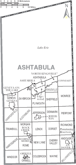
Geography
Ashtabula County is the largest county by area in the state of Ohio. According to the U.S. Census BureauUnited States Census Bureau
The United States Census Bureau is the government agency that is responsible for the United States Census. It also gathers other national demographic and economic data...
, the county has a total area of 1368 square miles (3,543.1 km²). 702 square miles (1,818.2 km²) is land and 666 square miles (1,724.9 km²) (48.67%) is water.
Adjacent counties
- Across Lake ErieLake ErieLake Erie is the fourth largest lake of the five Great Lakes in North America, and the tenth largest globally. It is the southernmost, shallowest, and smallest by volume of the Great Lakes and therefore also has the shortest average water residence time. It is bounded on the north by the...
lie ElginElgin County, OntarioElgin County is a county and census division of the Canadian province of Ontario with a current population of approximately 46,000. The county seat is St. Thomas.It consists of:*Town of Aylmer*Municipality of Bayham*Municipality of Central Elgin...
and NorfolkNorfolk County, OntarioNorfolk County is a rural city-status single-tier municipality on the north shore of Lake Erie in Southwestern Ontario, Canada. Bloomsburg is a small town located in Norfolk County and is the hometown of David Slater. The county seat and largest community is Simcoe...
Counties, OntarioOntarioOntario is a province of Canada, located in east-central Canada. It is Canada's most populous province and second largest in total area. It is home to the nation's most populous city, Toronto, and the nation's capital, Ottawa....
, CanadaCanadaCanada is a North American country consisting of ten provinces and three territories. Located in the northern part of the continent, it extends from the Atlantic Ocean in the east to the Pacific Ocean in the west, and northward into the Arctic Ocean...
(north) - Erie County, PennsylvaniaErie County, PennsylvaniaErie County is a county located in the U.S. state of Pennsylvania. As of 2010, the population was 280,566. Its county seat is the City of Erie.- Geography :...
(northeast) - Crawford County, PennsylvaniaCrawford County, PennsylvaniaCrawford County is a county located in the U.S. state of Pennsylvania. As of 2010, the population was 88,765.Crawford County was created on March 12, 1800, from part of Allegheny County and named for Colonel William Crawford...
(east) - Trumbull CountyTrumbull County, OhioAs of the census of 2000, there were 225,116 people, 89,020 households, and 61,690 families residing in the county. The population density was 365 people per square mile . There were 95,117 housing units at an average density of 154 per square mile...
(south) - Geauga CountyGeauga County, OhioGeauga County is a county located in the state of Ohio, United States. As of the 2010 census, the population was 93,389. It is named for a Native American word meaning "raccoon". The county seat is Chardon...
(southwest) - Lake CountyLake County, OhioLake County is a county located in the U.S. state of Ohio. As of 2010, the population was 230,041. The county seat is Painesville, and the county name comes from its location on the southern shore of Lake Erie....
(west)
Demographics
As of the censusCensus
A census is the procedure of systematically acquiring and recording information about the members of a given population. It is a regularly occurring and official count of a particular population. The term is used mostly in connection with national population and housing censuses; other common...
of 2000, there were 102,728 people, 39,397 households, and 27,774 families residing in the county. The population density
Population density
Population density is a measurement of population per unit area or unit volume. It is frequently applied to living organisms, and particularly to humans...
was 146 people per square mile (56/km²). There were 43,792 housing units at an average density of 62 per square mile (24/km²). The racial makeup of the county was 94.07% White
Race (United States Census)
Race and ethnicity in the United States Census, as defined by the Federal Office of Management and Budget and the United States Census Bureau, are self-identification data items in which residents choose the race or races with which they most closely identify, and indicate whether or not they are...
, 3.16% Black
Race (United States Census)
Race and ethnicity in the United States Census, as defined by the Federal Office of Management and Budget and the United States Census Bureau, are self-identification data items in which residents choose the race or races with which they most closely identify, and indicate whether or not they are...
or African American
Race (United States Census)
Race and ethnicity in the United States Census, as defined by the Federal Office of Management and Budget and the United States Census Bureau, are self-identification data items in which residents choose the race or races with which they most closely identify, and indicate whether or not they are...
, 0.19% Native American
Race (United States Census)
Race and ethnicity in the United States Census, as defined by the Federal Office of Management and Budget and the United States Census Bureau, are self-identification data items in which residents choose the race or races with which they most closely identify, and indicate whether or not they are...
, 0.34% Asian
Race (United States Census)
Race and ethnicity in the United States Census, as defined by the Federal Office of Management and Budget and the United States Census Bureau, are self-identification data items in which residents choose the race or races with which they most closely identify, and indicate whether or not they are...
, 0.02% Pacific Islander
Race (United States Census)
Race and ethnicity in the United States Census, as defined by the Federal Office of Management and Budget and the United States Census Bureau, are self-identification data items in which residents choose the race or races with which they most closely identify, and indicate whether or not they are...
, 0.85% from other races
Race (United States Census)
Race and ethnicity in the United States Census, as defined by the Federal Office of Management and Budget and the United States Census Bureau, are self-identification data items in which residents choose the race or races with which they most closely identify, and indicate whether or not they are...
, and 1.36% from two or more races. 2.23% of the population were Hispanic
Race (United States Census)
Race and ethnicity in the United States Census, as defined by the Federal Office of Management and Budget and the United States Census Bureau, are self-identification data items in which residents choose the race or races with which they most closely identify, and indicate whether or not they are...
or Latino
Race (United States Census)
Race and ethnicity in the United States Census, as defined by the Federal Office of Management and Budget and the United States Census Bureau, are self-identification data items in which residents choose the race or races with which they most closely identify, and indicate whether or not they are...
of any race. 19.3% were of German
Germans
The Germans are a Germanic ethnic group native to Central Europe. The English term Germans has referred to the German-speaking population of the Holy Roman Empire since the Late Middle Ages....
, 11.6% Italian
Italian people
The Italian people are an ethnic group that share a common Italian culture, ancestry and speak the Italian language as a mother tongue. Within Italy, Italians are defined by citizenship, regardless of ancestry or country of residence , and are distinguished from people...
, 10.6% English
English people
The English are a nation and ethnic group native to England, who speak English. The English identity is of early mediaeval origin, when they were known in Old English as the Anglecynn. England is now a country of the United Kingdom, and the majority of English people in England are British Citizens...
, 10.5% Irish
Irish people
The Irish people are an ethnic group who originate in Ireland, an island in northwestern Europe. Ireland has been populated for around 9,000 years , with the Irish people's earliest ancestors recorded having legends of being descended from groups such as the Nemedians, Fomorians, Fir Bolg, Tuatha...
and 10.3% American
United States
The United States of America is a federal constitutional republic comprising fifty states and a federal district...
ancestry according to Census 2000. 95.2% spoke English
English language
English is a West Germanic language that arose in the Anglo-Saxon kingdoms of England and spread into what was to become south-east Scotland under the influence of the Anglian medieval kingdom of Northumbria...
and 2.4% Spanish
Spanish language
Spanish , also known as Castilian , is a Romance language in the Ibero-Romance group that evolved from several languages and dialects in central-northern Iberia around the 9th century and gradually spread with the expansion of the Kingdom of Castile into central and southern Iberia during the...
as their first language.
There were 39,397 households out of which 32.40% had children under the age of 18 living with them, 54.80% were married couples
Marriage
Marriage is a social union or legal contract between people that creates kinship. It is an institution in which interpersonal relationships, usually intimate and sexual, are acknowledged in a variety of ways, depending on the culture or subculture in which it is found...
living together, 11.40% had a female householder with no husband present, and 29.50% were non-families. 24.80% of all households were made up of individuals and 10.70% had someone living alone who was 65 years of age or older. The average household size was 2.56 and the average family size was 3.05.
In the county the population was spread out with 26.20% under the age of 18, 7.60% from 18 to 24, 28.00% from 25 to 44, 23.60% from 45 to 64, and 14.70% who were 65 years of age or older. The median age was 38 years. For every 100 females there were 95.10 males. For every 100 females age 18 and over, there were 92.10 males.
The median income for a household in the county was $35,607, and the median income for a family was $42,449. Males had a median income of $33,105 versus $22,624 for females. The per capita income
Per capita income
Per capita income or income per person is a measure of mean income within an economic aggregate, such as a country or city. It is calculated by taking a measure of all sources of income in the aggregate and dividing it by the total population...
for the county was $16,814. About 9.20% of families and 12.10% of the population were below the poverty line, including 17.10% of those under age 18 and 8.60% of those age 65 or over.
Government
Major Highways
-
 Interstate 90Interstate 90Interstate 90 is the longest Interstate Highway in the United States at . It is the northernmost coast-to-coast interstate, and parallels US 20 for the most part. Its western terminus is in Seattle, at Edgar Martinez Drive S. near Safeco Field and CenturyLink Field, and its eastern terminus is in...
 -
 Ohio State Route 7
 -
 Ohio State Route 11
 -
 Ohio State Route 167Ohio State Route 167State Route 167 is an east–west state highway in the northeastern portion of the U.S. state of Ohio. Its western terminus is at the northern end of the State Route 46 and State Route 307 concurrency in Jefferson, and its eastern terminus is at the Pennsylvania state line about south of...
 -
 US Route 6
 -
 US Route 20
 -
 US Route 322
Communities
Villages
|
North Kingsville, Ohio North Kingsville is a village in Ashtabula County, Ohio, United States. The population was 2,658 at the 2000 census.-Geography:North Kingsville is located at .... Orwell, Ohio Orwell is a village in Ashtabula County, Ohio, United States. The population was 1,519 at the 2000 census. It is the birthplace of General Adna Chaffee, and of Russell Allen, as of 2006 the oldest living American Olympic cyclist.... |
Roaming Shores, Ohio Roaming Shores is a village in Ashtabula County, Ohio, United States. The population was 1,239 at the 2000 census.-Geography:Roaming Shores is located at .... Rock Creek, Ohio Rock Creek is a village in Ashtabula County, Ohio, United States. The population was 584 at the 2000 census.The principal village festival is the Ox Roast... |
Townships
|
Hartsgrove Township, Ashtabula County, Ohio Hartsgrove Township is one of the twenty-seven townships of Ashtabula County, Ohio, United States. The 2000 census found 1,395 people in the township.-Geography:Located on the southwestern edge of the county, it borders the following townships:... Jefferson Township, Ashtabula County, Ohio Jefferson Township is one of the twenty-seven townships of Ashtabula County, Ohio, United States. The 2000 census found 5,559 people in the township, 1,987 of whom lived in the unincorporated portions of the township.-Geography:... Kingsville Township, Ashtabula County, Ohio Kingsville Township is one of the twenty-seven townships of Ashtabula County, Ohio, United States. The 2000 census found 1,847 people in the township.-Geography:... Lenox Township, Ashtabula County, Ohio Lenox Township is one of the twenty-seven townships of Ashtabula County, Ohio, United States. The 2000 census found 1,388 people in the township.-Geography:Located in the center of the county, it borders the following townships:*Jefferson Township - north... Monroe Township, Ashtabula County, Ohio Monroe Township is one of the twenty-seven townships of Ashtabula County, Ohio, United States. The 2000 census found 2,268 people in the township.-Geography:Located on the northeastern edge of the county, it borders the following townships and city:... Morgan Township, Ashtabula County, Ohio Morgan Township is one of the twenty-seven townships of Ashtabula County, Ohio, United States. The 2000 census found 1,954 people in the township, 780 of whom lived in the unincorporated portions of the township.-Geography:... New Lyme Township, Ashtabula County, Ohio New Lyme Township is one of the twenty-seven townships of Ashtabula County, Ohio, United States. The 2000 census found 1,072 people in the township.-Geography:Located in the southern part of the county, it borders the following townships:... Orwell Township, Ashtabula County, Ohio Orwell Township is one of the twenty-seven townships of Ashtabula County, Ohio, United States. The 2000 census found 2,830 people in the township, 1,311 of whom lived in the unincorporated portions of the township.-Geography:... Pierpont Township, Ashtabula County, Ohio Pierpont Township is one of the twenty-seven townships of Ashtabula County, Ohio, United States. The 2000 census found 1,197 people in the township.-Geography:Located on the eastern edge of the county, it borders the following townships:... |
Plymouth Township, Ashtabula County, Ohio Plymouth Township is one of the twenty-seven townships of Ashtabula County, Ohio, United States. The 2000 census found 2,081 people in the township.-Geography:Located in the northern part of the county, it borders the following townships:... Richmond Township, Ashtabula County, Ohio Richmond Township is one of the twenty-seven townships of Ashtabula County, Ohio, United States. The 2000 census found 937 people in the township.-Geography:Located on the eastern edge of the county, it borders the following townships:... Rome Township, Ashtabula County, Ohio Rome Township is one of the twenty-seven townships of Ashtabula County, Ohio, United States. The 2000 census found 1,568 people in the township, 919 of whom lived in the unincorporated portions of the township.-Geography:... Saybrook Township, Ashtabula County, Ohio Saybrook Township is one of the twenty-seven townships of Ashtabula County, Ohio, United States. The 2000 census found 10,051 people in the township, 5,957 of whom lived in the unincorporated portions of the township.-Geography:... Sheffield Township, Ashtabula County, Ohio Sheffield Township is one of the twenty-seven townships of Ashtabula County, Ohio, United States. The 2000 census found 1,491 people in the township.-Geography:Located in the northeastern part of the county, it borders the following townships:... Trumbull Township, Ashtabula County, Ohio Trumbull Township is one of the twenty-seven townships of Ashtabula County, Ohio, United States. The 2000 census found 1,461 people in the township.-Geography:Located on the western edge of the county, it borders the following townships:... Wayne Township, Ashtabula County, Ohio Wayne Township is one of the twenty-seven townships of Ashtabula County, Ohio, United States. The 2000 census found 653 people in the township.-Geography:Located on the southwestern edge of the county, it borders the following townships:... Williamsfield Township, Ashtabula County, Ohio Williamsfield Township is one of the twenty-seven townships of Ashtabula County, Ohio, United States. The 2000 census found 1,683 people in the township.-Geography:Located in the southeastern corner of the county, it borders the following townships:... Windsor Township, Ashtabula County, Ohio Windsor Township is one of the twenty-seven townships of Ashtabula County, Ohio, United States. The 2000 census found 1,932 people in the township.-Geography:Located in the southwestern corner of the county, it borders the following townships:... |
Other communities
|
Kingsville, Ohio Kingsville is a census-designated place in central Kingsville Township, Ashtabula County, Ohio, United States. Although it is unincorporated, it has a post office, with the ZIP code of 44048... Pierpont, Ohio Pierpont is an unincorporated community in central Pierpont Township, Ashtabula County, Ohio, United States. Although it is unincorporated, it has a post office, with the ZIP code of 44082. It lies at the intersection of State Routes 7 and 167.-References:... Unionville, Ohio Unionville is an unincorporated community on the line between northwestern Harpersfield Township in Ashtabula County and eastern Madison Township in Lake County in the U.S. state of Ohio. Although it is unincorporated, it has a post office, with the ZIP code of 44088... |
Williamsfield, Ohio Williamsfield is an unincorporated community in central Williamsfield Township, Ashtabula County, Ohio, United States. Although it is unincorporated, it has a post office, with the ZIP code of 44093. It lies at the intersection of U.S. Route 322 with State Route 7.-References:... Windsor, Ohio Windsor is an unincorporated community in eastern Windsor Township, Ashtabula County, Ohio, United States. Although it is unincorporated, it has a post office, with the ZIP code of 44099. It lies at the intersection of U.S. Route 322 with State Route 534.... |
Culture
Ashtabula County is home to many Finnish AmericanFinnish American
Finnish Americans are Americans of Finnish descent, who currently number about 700,000.-History:Some Finns, like the ancestors of John Morton, came to the Swedish colony of New Sweden, that existed in mid-17th century....
s, and an annual FinnFest USA celebration is held in Ashtabula.http://www.finnfestusa2007.com/
Ashtabula County has a large number of covered bridge
Covered bridge
A covered bridge is a bridge with enclosed sides and a roof, often accommodating only a single lane of traffic. Most covered bridges are wooden; some newer ones are concrete or metal with glass sides...
s. See List of Ashtabula County covered bridges.
Notable people
- Chester H. Aldrich (1862–1924), Governor of NebraskaGovernor of NebraskaThe Governor of Nebraska holds the "supreme executive power" of the State of Nebraska as provided by the fourth article of the Nebraska Constitution. The current Governor is Dave Heineman, a Republican, who assumed office on January 20, 2005 upon the resignation of Mike Johanns . He won a full...
1911-1913. - Brian AndersonBrian Anderson (pitcher)Brian James Anderson is an American former Major League Baseball pitcher, who played 13 season for five teams, as well as a sports broadcaster and coach. Currently, Anderson is the color commentator on the Rays TV crew on Sun Sports....
, Cleveland IndiansCleveland IndiansThe Cleveland Indians are a professional baseball team based in Cleveland, Ohio. They are in the Central Division of Major League Baseball's American League. Since , they have played in Progressive Field. The team's spring training facility is in Goodyear, Arizona...
Pitcher, originally from Geneva. - Charles CaseCharles CaseCharles Case was a U.S. Representative from Indiana.-Biography:Case was born in Austinburg, Ohio; studied law; was admitted to the bar and commenced practice in Fort Wayne, Indiana.; elected as a Republican to the Thirty-fifth United States Congress to fill the vacancy caused by the death of...
(1817–1883), born in Austinburg, United States Congressman from IndianaIndianaIndiana is a US state, admitted to the United States as the 19th on December 11, 1816. It is located in the Midwestern United States and Great Lakes Region. With 6,483,802 residents, the state is ranked 15th in population and 16th in population density. Indiana is ranked 38th in land area and is...
. - Tammy CochranTammy CochranTammy Cochran is an American country music artist. Signed to Epic Records Nashville in 2000, she released her self titled debut album that year, followed a year later by Life Happened...
, country music singer from Austinburg. Biggest hit was Angels In Waiting. - Edwin CowlesEdwin CowlesEdwin Cowles , born in Austinburg, was the publisher of The Cleveland Leader, Vice-President of the 1884 Republican National Convention, postmaster of Cleveland, April 4, 1861 - July 11, 1865, and elder brother of Alfred Cowles, Sr., also a newspaper publisher.-References:...
, (1825–1890), born in Austinburg, publisher of The Cleveland Leader, Vice-President of the 1884 Republican National ConventionRepublican National ConventionThe Republican National Convention is the presidential nominating convention of the Republican Party of the United States. Convened by the Republican National Committee, the stated purpose of the convocation is to nominate an official candidate in an upcoming U.S... - Joshua Reed GiddingsJoshua Reed GiddingsJoshua Reed Giddings was an American statesman and a prominent opponent of slavery. He represented Ohio in the U.S. House of Representatives from 1838-59. He was at first a member of the Whig Party and was later a Republican.-Life:He was born at Tioga Point, now Athens, Bradford County,...
(1795–1864), member of the U.S. House of Representatives and prominent opponent of slaverySlaverySlavery is a system under which people are treated as property to be bought and sold, and are forced to work. Slaves can be held against their will from the time of their capture, purchase or birth, and deprived of the right to leave, to refuse to work, or to demand compensation...
. - Francis Joseph HallFrancis Joseph HallFrancis Joseph Hall was an American Protestant Episcopal theologian, born in Ashtabula, Ohio. He graduated from Racine College in 1882 and studied at the General Theological Seminary and the Western Theological Seminary in Chicago, Illinois theological seminaries...
, was an American Protestant Episcopal theologian and author. - Ken MeyerKen MeyerKen Meyer is a former football coach at the high school, collegiate and professional levels. He may be best remembered as the head coach of the National Football League's San Francisco 49ers in 1977....
, was head coach of the National Football League's San Francisco 49ers in 1977. - Urban MeyerUrban MeyerUrban Frank Meyer, III is an American football coach and former player. He is head football coach at Ohio State University, having been hired for the position in November 2011...
, formerly the head football coach at the University of Florida, and current television sports analyst. - James MontgomeryJames Montgomery (colonel)James Montgomery was a Jayhawker during the Bleeding Kansas Affair and a controversial Union colonel during the American Civil War...
, (1814–1871), born in Ashtabula County, colonel in the American Civil WarAmerican Civil WarThe American Civil War was a civil war fought in the United States of America. In response to the election of Abraham Lincoln as President of the United States, 11 southern slave states declared their secession from the United States and formed the Confederate States of America ; the other 25...
, raided several towns in Missouri and the American South. - Ransom Eli Olds, was a pioneer of the American automobile industry, for whom both the Oldsmobile and Reo brands were named.
- Louis C. ShepardLouis C. ShepardLewis Capet Shepard was born in Ashtabula County, Ohio and was a Union Navy sailor during the American Civil War who received America's highest military decoration the Medal of Honor for his actions at the Second Battle of Fort Fisher...
, American Civil WarAmerican Civil WarThe American Civil War was a civil war fought in the United States of America. In response to the election of Abraham Lincoln as President of the United States, 11 southern slave states declared their secession from the United States and formed the Confederate States of America ; the other 25...
Medal of HonorMedal of HonorThe Medal of Honor is the highest military decoration awarded by the United States government. It is bestowed by the President, in the name of Congress, upon members of the United States Armed Forces who distinguish themselves through "conspicuous gallantry and intrepidity at the risk of his or her...
recipient from Ashtabula County, buried in Lakeview cemetery, Port ClintonPort Clinton, OhioPort Clinton is a city in and the county seat of Ottawa County, Ohio, United States. The population was 6,056 at the 2010 census. The city has been nicknamed the "Walleye Capital of the World."...
, Ottawa County, OhioOttawa County, OhioOttawa County is a county located in the state of Ohio, United States. As of the 2010 census, the population was 41,428. Its county seat is Port Clinton and is named either for the Ottawa Indians who lived there, or for an Indian word meaning "trader"....
. - Decius WadeDecius WadeDecius Spear Wade was an American attorney, judge, writer, and politician who has been called the "Father of Montana Jurisprudence" for his role in establishing the common law and statutory law of the U.S. state of Montana...
, was an American attorney, judge, writer, and politician who has been called the "Father of Montana Jurisprudence" for his role in establishing the common law and statutory law of the U.S. state of Montana.