
Meigs County, Tennessee
Encyclopedia
Meigs County is a county located in the U.S. state
of Tennessee
. As of 2010, the population was 11,753. Its county seat
is Decatur
.
territory. White settlers established ferries
to cross the Tennessee River
from Rhea County
as early as 1807. Col. Return J. Meigs
, who was to become the county's namesake, operated an Indian agency across the river in Rhea County until 1817, when the agency moved east to the area that is now Meigs County. In 1819 the Hiwassee Treaty opened the land to white settlement, initially as a part of Rhea County.
In 1985, the Meigs County Family and Community Education (“FCE”) Club began a large quilt to commemorate the early history of Meigs County, for a state project, the Tennessee “Homecoming 1986." The quilt includes images of fourteen sites representing the early history of Meigs County. The central quilt design, including a map of the area to locate the various sites represented, was created by the late Flossie Bennett, a longtime leader of the FCE. A committee of representatives from Ten Mile, Peakland, Concord, Goodfield, and Decatur, decided which sites would be included in the quilt. The sites chosen were the Elisha Sharp House
(also known as the Sharp-Wasson-Worth House, c. 1825), the Stewart House (1830), the R.H. Johnson Stable, the Mount Zion church and Cemetery (1830), Zeigler's Mill (1850,previously Gettys Mill), the Washington Ferry (1808), the Pisah Church (1818), the old gymnasium (c. 1822), the old Meigs County Courthouse (1904), the old Volunteer Electric Cooperative BUilding (1935), the Ashley House (1885), and the Sam Eaves Store (c. 1861). Nell Jeannette Fields Worth also insisted that images of Hereford cattle be included throughout the quilt, since Meigs County is noted for its beef cattle. The quilt was awarded the “Best Original Design” at the McMinn County Living Heritage Museum's Quilt Show. The quilt initially was displayed at the Meigs-Decatur Public Library, and as of 2010, now hangs in the Meigs County Historical Museum, in Decatur, Tennessee.
A new building on Smith Avenue in Decatur, Tennessee, was built to house the collection of the Meigs County historical Museum. The new site was opened in July 2002. The Meigs County Historical Museum houses many court and family records. On permanent display is a mural depicting Main Street Decatur in the 1930s. The mural was funded by grants from the Tennessee Arts Commission and the VEC Customershares program and painted by Bill McDonald, a local artist.
, the county has a total area of 217 square miles (562 km²), of which 195 square miles (505 km²) is land and 22 square miles (57 km²) (10.11%) is water.
The main geographic feature of Meigs County is the Tennessee River
, which provides the county's western boundary. Watts Bar Dam
is located along the river between Meigs and adjacent Rhea County, and forms Watts Bar Lake
, which spans the river upstream to Fort Loudoun Dam
just west of Knoxville
. Watts Bar Dam's tailwaters are part of Chickamauga Lake
, which stretches downstream to Chickamauga Dam
in Chattanooga
. The mouth of the Hiwassee River
is located in southwestern Meigs County, near the point where Meigs, Rhea, and Hamilton counties meet.
State Route 30 - The principal east/west highway. This highway divides the county into north and south and intersects Highway 58 in Decatur
. The Tennessee Department of Transportation
is in the process of upgrading Highway 30 from a 2-lane highway to a 4-lane divided highway. allowing for more major east/west traffic and faster connection to Interstate 75
. (The section from Decatur eastward was finished in 2008.)
State Route 68 - A north/south main highway for the county, that actually runs east/west though the northern county. This highway crosses the Tennessee River
at Watts Bar Dam
.
State Route 60 - A principal east/west highway forming the southern border of the county.
State Route 304 - An important local road, mainly for local residents that live off of the highway, and its northern portions allows access to Watts Bar Lake
's many marinas, resorts, and campgrounds. Also connects the unincorporated
community of Ten Mile
with the county seat of Decatur.
State Route 305 - An important local road, connecting Interstate 75
with State Route 68 and State Route 58. This also connects the north-central part of the county with the neighboring city of Athens
in McMinn County.
 As of the census
of 2000, there were 11,086 people, 4,304 households, and 3,262 families residing in the county. The population density
was 57 people per square mile (22/km²). There were 5,188 housing units at an average density of 27 per square mile (10/km²). The racial makeup of the county was 97.65% White
, 1.24% Black
or African American
, 0.21% Native American
, 0.18% Asian
, 0.11% from other races
, and 0.60% from two or more races. 0.57% of the population were Hispanic
or Latino
of any race.
There were 4,304 households out of which 32.80% had children under the age of 18 living with them, 61.70% were married couples
living together, 9.90% had a female householder with no husband present, and 24.20% were non-families. 20.80% of all households were made up of individuals and 7.80% had someone living alone who was 65 years of age or older. The average household size was 2.55 and the average family size was 2.94.
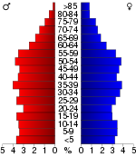
In the county the population was spread out with 25.10% under the age of 18, 8.10% from 18 to 24, 28.90% from 25 to 44, 26.30% from 45 to 64, and 11.50% who were 65 years of age or older. The median age was 37 years. For every 100 females there were 100.00 males. For every 100 females age 18 and over, there were 97.30 males.
The median income for a household in the county was $29,354, and the median income for a family was $34,114. Males had a median income of $29,521 versus $20,419 for females. The per capita income
for the county was $14,551. About 15.80% of families and 18.30% of the population were below the poverty line, including 23.50% of those under age 18 and 14.60% of those age 65 or over.
, the county seat, is the only incorporated municipality
in Meigs County. Unincorporated
communities include Ten Mile
and Georgetown
.
U.S. state
A U.S. state is any one of the 50 federated states of the United States of America that share sovereignty with the federal government. Because of this shared sovereignty, an American is a citizen both of the federal entity and of his or her state of domicile. Four states use the official title of...
of Tennessee
Tennessee
Tennessee is a U.S. state located in the Southeastern United States. It has a population of 6,346,105, making it the nation's 17th-largest state by population, and covers , making it the 36th-largest by total land area...
. As of 2010, the population was 11,753. Its county seat
County seat
A county seat is an administrative center, or seat of government, for a county or civil parish. The term is primarily used in the United States....
is Decatur
Decatur, Tennessee
Decatur is a town in Meigs County, Tennessee, United States. The population was 1,395 at the 2000 census. It is the county seat of Meigs County.The local pronunciation of the name is duh▪KAY▪ter .-Geography:Decatur is located at...
.
History
Before 1819, the area that is now Meigs County was CherokeeCherokee
The Cherokee are a Native American people historically settled in the Southeastern United States . Linguistically, they are part of the Iroquoian language family...
territory. White settlers established ferries
Ferry
A ferry is a form of transportation, usually a boat, but sometimes a ship, used to carry primarily passengers, and sometimes vehicles and cargo as well, across a body of water. Most ferries operate on regular, frequent, return services...
to cross the Tennessee River
Tennessee River
The Tennessee River is the largest tributary of the Ohio River. It is approximately 652 miles long and is located in the southeastern United States in the Tennessee Valley. The river was once popularly known as the Cherokee River, among other names...
from Rhea County
Rhea County, Tennessee
Rhea County is a county located in the U.S. state of Tennessee. As of 2000, the population was 28,400. Its county seat is Dayton.-Geography:According to the U.S...
as early as 1807. Col. Return J. Meigs
Return J. Meigs, Sr.
Return Jonathan Meigs [born December 17 or December 28 , 1740; died January 28, 1823] was a colonel who served in the Continental Army during the American Revolutionary War, was one of the founding settlers of the Northwest Territory in what is now the state of Ohio, and later served as a federal...
, who was to become the county's namesake, operated an Indian agency across the river in Rhea County until 1817, when the agency moved east to the area that is now Meigs County. In 1819 the Hiwassee Treaty opened the land to white settlement, initially as a part of Rhea County.
In 1985, the Meigs County Family and Community Education (“FCE”) Club began a large quilt to commemorate the early history of Meigs County, for a state project, the Tennessee “Homecoming 1986." The quilt includes images of fourteen sites representing the early history of Meigs County. The central quilt design, including a map of the area to locate the various sites represented, was created by the late Flossie Bennett, a longtime leader of the FCE. A committee of representatives from Ten Mile, Peakland, Concord, Goodfield, and Decatur, decided which sites would be included in the quilt. The sites chosen were the Elisha Sharp House
Elisha Sharp House
The Elisha Sharp House is a house in Ten Mile, Tennessee. It was added to the National Register of Historic Places on July 6, 1982.Elisha Sharp was born July 25, 1792, and died December 6, 1863. In 1817, he married Elinore Ellen Huff . She was sixteen years old, and he was twenty five...
(also known as the Sharp-Wasson-Worth House, c. 1825), the Stewart House (1830), the R.H. Johnson Stable, the Mount Zion church and Cemetery (1830), Zeigler's Mill (1850,previously Gettys Mill), the Washington Ferry (1808), the Pisah Church (1818), the old gymnasium (c. 1822), the old Meigs County Courthouse (1904), the old Volunteer Electric Cooperative BUilding (1935), the Ashley House (1885), and the Sam Eaves Store (c. 1861). Nell Jeannette Fields Worth also insisted that images of Hereford cattle be included throughout the quilt, since Meigs County is noted for its beef cattle. The quilt was awarded the “Best Original Design” at the McMinn County Living Heritage Museum's Quilt Show. The quilt initially was displayed at the Meigs-Decatur Public Library, and as of 2010, now hangs in the Meigs County Historical Museum, in Decatur, Tennessee.
A new building on Smith Avenue in Decatur, Tennessee, was built to house the collection of the Meigs County historical Museum. The new site was opened in July 2002. The Meigs County Historical Museum houses many court and family records. On permanent display is a mural depicting Main Street Decatur in the 1930s. The mural was funded by grants from the Tennessee Arts Commission and the VEC Customershares program and painted by Bill McDonald, a local artist.
Geography
According to the U.S. Census BureauUnited States Census Bureau
The United States Census Bureau is the government agency that is responsible for the United States Census. It also gathers other national demographic and economic data...
, the county has a total area of 217 square miles (562 km²), of which 195 square miles (505 km²) is land and 22 square miles (57 km²) (10.11%) is water.
The main geographic feature of Meigs County is the Tennessee River
Tennessee River
The Tennessee River is the largest tributary of the Ohio River. It is approximately 652 miles long and is located in the southeastern United States in the Tennessee Valley. The river was once popularly known as the Cherokee River, among other names...
, which provides the county's western boundary. Watts Bar Dam
Watts Bar Dam
Watts Bar Dam is a hydroelectric dam on the Tennessee River in Meigs County and Rhea County, Tennessee, USA. The dam is one of nine dams on the main Tennessee River channel operated by the Tennessee Valley Authority, which built the dam in early 1940s to provide flood control and electricity and...
is located along the river between Meigs and adjacent Rhea County, and forms Watts Bar Lake
Watts Bar Lake
Watts Bar Lake is a reservoir on the Tennessee River created by Watts Bar Dam as part of the Tennessee Valley Authority system.-Geography:Located about midway between Chattanooga and Knoxville, the lake begins as the Tennessee River below Fort Loudon Dam in Lenoir City, Tennessee and stretches...
, which spans the river upstream to Fort Loudoun Dam
Fort Loudoun Dam
Fort Loudoun Dam is a hydroelectric dam on the Tennessee River in Loudon County, Tennessee, in the southeastern United States. The dam is operated by the Tennessee Valley Authority , which built the dam in the early 1940s as part of a unified plan to provide electricity and flood control in the...
just west of Knoxville
Knoxville, Tennessee
Founded in 1786, Knoxville is the third-largest city in the U.S. state of Tennessee, U.S.A., behind Memphis and Nashville, and is the county seat of Knox County. It is the largest city in East Tennessee, and the second-largest city in the Appalachia region...
. Watts Bar Dam's tailwaters are part of Chickamauga Lake
Chickamauga Lake
Chickamauga Lake is a United States reservoir along the Tennessee River created when the Chickamauga Dam, as part of the Tennessee Valley Authority, was completed in 1940. The lake stretches from Watts Bar Dam at mile 529.9 to Chickamauga Dam at mile 471.0 making the lake 58.9 miles long...
, which stretches downstream to Chickamauga Dam
Chickamauga Dam
Chickamauga Dam is a hydroelectric dam on the Tennessee River in Chattanooga, Tennessee, USA. The dam is owned and operated by the Tennessee Valley Authority, which built the dam in the late 1930s as part of a New Deal era initiative to improve navigation and bring flood control and economic...
in Chattanooga
Chattanooga, Tennessee
Chattanooga is the fourth-largest city in the US state of Tennessee , with a population of 169,887. It is the seat of Hamilton County...
. The mouth of the Hiwassee River
Hiwassee River
The Hiwassee River has its headwaters on the north slope of Rocky Mountain in Towns County in northern Georgia and flows northward into North Carolina before turning westward into Tennessee, flowing into the Tennessee River a few miles west of State Route 58 in Meigs County, Tennessee...
is located in southwestern Meigs County, near the point where Meigs, Rhea, and Hamilton counties meet.
Transportation
State Route 58 - The principal north/south highway, runs the entire length of the county dividing the county down the middle. The only link via the Hiwassee River Bridge to the southernmost part of the county.State Route 30 - The principal east/west highway. This highway divides the county into north and south and intersects Highway 58 in Decatur
Decatur, Tennessee
Decatur is a town in Meigs County, Tennessee, United States. The population was 1,395 at the 2000 census. It is the county seat of Meigs County.The local pronunciation of the name is duh▪KAY▪ter .-Geography:Decatur is located at...
. The Tennessee Department of Transportation
Tennessee Department of Transportation
The Tennessee Department of Transportation is a multimodal agency with statewide responsibilities in aviation, public transit, waterways and railroads...
is in the process of upgrading Highway 30 from a 2-lane highway to a 4-lane divided highway. allowing for more major east/west traffic and faster connection to Interstate 75
Interstate 75
Interstate 75 is a major north–south Interstate Highway in the Great Lakes and Southeastern regions of the United States. It travels from State Road 826 and State Road 924 in Hialeah, Florida to Sault Ste. Marie, Michigan, at the Ontario, Canada, border...
. (The section from Decatur eastward was finished in 2008.)
State Route 68 - A north/south main highway for the county, that actually runs east/west though the northern county. This highway crosses the Tennessee River
Tennessee River
The Tennessee River is the largest tributary of the Ohio River. It is approximately 652 miles long and is located in the southeastern United States in the Tennessee Valley. The river was once popularly known as the Cherokee River, among other names...
at Watts Bar Dam
Watts Bar Dam
Watts Bar Dam is a hydroelectric dam on the Tennessee River in Meigs County and Rhea County, Tennessee, USA. The dam is one of nine dams on the main Tennessee River channel operated by the Tennessee Valley Authority, which built the dam in early 1940s to provide flood control and electricity and...
.
State Route 60 - A principal east/west highway forming the southern border of the county.
State Route 304 - An important local road, mainly for local residents that live off of the highway, and its northern portions allows access to Watts Bar Lake
Watts Bar Lake
Watts Bar Lake is a reservoir on the Tennessee River created by Watts Bar Dam as part of the Tennessee Valley Authority system.-Geography:Located about midway between Chattanooga and Knoxville, the lake begins as the Tennessee River below Fort Loudon Dam in Lenoir City, Tennessee and stretches...
's many marinas, resorts, and campgrounds. Also connects the unincorporated
Unincorporated area
In law, an unincorporated area is a region of land that is not a part of any municipality.To "incorporate" in this context means to form a municipal corporation, a city, town, or village with its own government. An unincorporated community is usually not subject to or taxed by a municipal government...
community of Ten Mile
Ten Mile, Tennessee
Ten Mile is an unincorporated area in northern Meigs and southeastern Roane counties in the U.S. state of Tennessee. The Roane County portion is included in the Harriman, Tennessee Micropolitan Statistical Area....
with the county seat of Decatur.
State Route 305 - An important local road, connecting Interstate 75
Interstate 75
Interstate 75 is a major north–south Interstate Highway in the Great Lakes and Southeastern regions of the United States. It travels from State Road 826 and State Road 924 in Hialeah, Florida to Sault Ste. Marie, Michigan, at the Ontario, Canada, border...
with State Route 68 and State Route 58. This also connects the north-central part of the county with the neighboring city of Athens
Athens, Tennessee
Athens is a city in McMinn County, Tennessee, United States. It is the county seat of McMinn County and the principal city of the Athens Micropolitan Statistical Area, which is part of the larger Chattanooga-Cleveland-Athens Combined Statistical Area. The population was 13,220 at the 2000...
in McMinn County.
Adjacent counties
- Roane County, Tennessee (North)
- McMinn County, Tennessee (East)
- Bradley County, Tennessee (Southeast)
- Hamilton County, TennesseeHamilton County, TennesseeHamilton County is a county located in the U.S. state of Tennessee. It was named for Alexander Hamilton, the first Secretary of the Treasury. The 2005 Census Estimate placed the population at 310,935 . Its county seat is Chattanooga....
(South) - Rhea County, TennesseeRhea County, TennesseeRhea County is a county located in the U.S. state of Tennessee. As of 2000, the population was 28,400. Its county seat is Dayton.-Geography:According to the U.S...
(West)
Demographics
Census
A census is the procedure of systematically acquiring and recording information about the members of a given population. It is a regularly occurring and official count of a particular population. The term is used mostly in connection with national population and housing censuses; other common...
of 2000, there were 11,086 people, 4,304 households, and 3,262 families residing in the county. The population density
Population density
Population density is a measurement of population per unit area or unit volume. It is frequently applied to living organisms, and particularly to humans...
was 57 people per square mile (22/km²). There were 5,188 housing units at an average density of 27 per square mile (10/km²). The racial makeup of the county was 97.65% White
Race (United States Census)
Race and ethnicity in the United States Census, as defined by the Federal Office of Management and Budget and the United States Census Bureau, are self-identification data items in which residents choose the race or races with which they most closely identify, and indicate whether or not they are...
, 1.24% Black
Race (United States Census)
Race and ethnicity in the United States Census, as defined by the Federal Office of Management and Budget and the United States Census Bureau, are self-identification data items in which residents choose the race or races with which they most closely identify, and indicate whether or not they are...
or African American
Race (United States Census)
Race and ethnicity in the United States Census, as defined by the Federal Office of Management and Budget and the United States Census Bureau, are self-identification data items in which residents choose the race or races with which they most closely identify, and indicate whether or not they are...
, 0.21% Native American
Race (United States Census)
Race and ethnicity in the United States Census, as defined by the Federal Office of Management and Budget and the United States Census Bureau, are self-identification data items in which residents choose the race or races with which they most closely identify, and indicate whether or not they are...
, 0.18% Asian
Race (United States Census)
Race and ethnicity in the United States Census, as defined by the Federal Office of Management and Budget and the United States Census Bureau, are self-identification data items in which residents choose the race or races with which they most closely identify, and indicate whether or not they are...
, 0.11% from other races
Race (United States Census)
Race and ethnicity in the United States Census, as defined by the Federal Office of Management and Budget and the United States Census Bureau, are self-identification data items in which residents choose the race or races with which they most closely identify, and indicate whether or not they are...
, and 0.60% from two or more races. 0.57% of the population were Hispanic
Race (United States Census)
Race and ethnicity in the United States Census, as defined by the Federal Office of Management and Budget and the United States Census Bureau, are self-identification data items in which residents choose the race or races with which they most closely identify, and indicate whether or not they are...
or Latino
Race (United States Census)
Race and ethnicity in the United States Census, as defined by the Federal Office of Management and Budget and the United States Census Bureau, are self-identification data items in which residents choose the race or races with which they most closely identify, and indicate whether or not they are...
of any race.
There were 4,304 households out of which 32.80% had children under the age of 18 living with them, 61.70% were married couples
Marriage
Marriage is a social union or legal contract between people that creates kinship. It is an institution in which interpersonal relationships, usually intimate and sexual, are acknowledged in a variety of ways, depending on the culture or subculture in which it is found...
living together, 9.90% had a female householder with no husband present, and 24.20% were non-families. 20.80% of all households were made up of individuals and 7.80% had someone living alone who was 65 years of age or older. The average household size was 2.55 and the average family size was 2.94.
In the county the population was spread out with 25.10% under the age of 18, 8.10% from 18 to 24, 28.90% from 25 to 44, 26.30% from 45 to 64, and 11.50% who were 65 years of age or older. The median age was 37 years. For every 100 females there were 100.00 males. For every 100 females age 18 and over, there were 97.30 males.
The median income for a household in the county was $29,354, and the median income for a family was $34,114. Males had a median income of $29,521 versus $20,419 for females. The per capita income
Per capita income
Per capita income or income per person is a measure of mean income within an economic aggregate, such as a country or city. It is calculated by taking a measure of all sources of income in the aggregate and dividing it by the total population...
for the county was $14,551. About 15.80% of families and 18.30% of the population were below the poverty line, including 23.50% of those under age 18 and 14.60% of those age 65 or over.
Cities and towns
DecaturDecatur, Tennessee
Decatur is a town in Meigs County, Tennessee, United States. The population was 1,395 at the 2000 census. It is the county seat of Meigs County.The local pronunciation of the name is duh▪KAY▪ter .-Geography:Decatur is located at...
, the county seat, is the only incorporated municipality
Municipal corporation
A municipal corporation is the legal term for a local governing body, including cities, counties, towns, townships, charter townships, villages, and boroughs. Municipal incorporation occurs when such municipalities become self-governing entities under the laws of the state or province in which...
in Meigs County. Unincorporated
Unincorporated area
In law, an unincorporated area is a region of land that is not a part of any municipality.To "incorporate" in this context means to form a municipal corporation, a city, town, or village with its own government. An unincorporated community is usually not subject to or taxed by a municipal government...
communities include Ten Mile
Ten Mile, Tennessee
Ten Mile is an unincorporated area in northern Meigs and southeastern Roane counties in the U.S. state of Tennessee. The Roane County portion is included in the Harriman, Tennessee Micropolitan Statistical Area....
and Georgetown
Georgetown, Tennessee
Georgetown is an unincorporated community at the junction of Bradley, Hamilton, and Meigs counties in the U.S. state of Tennessee. The small community is located along State Route 60....
.