
Wayne County, Kentucky
Encyclopedia
Wayne County is a county located in the U.S. state
of Kentucky
. As of 2000, the population was 19,923. Its county seat
is Monticello
. The county was named for Gen. Anthony Wayne
. It is a prohibition or dry county
.
and Cumberland
Counties. It was the 43rd county and is named for General "Mad Anthony" Wayne
.
 According to the 2000 census, the county has a total area of 484.2 square miles (1,254.1 km²), of which 459.4 square miles (1,189.8 km²) (or 94.88%) is land and 24.8 square miles (64.2 km²) (or 5.12%) is water.
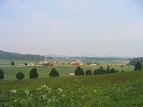
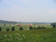
The county's elevation ranges from 723 feet (220.4 m) to 1788 feet (545 m), at the Monticello/Wayne County Airport the elevation is 963 feet (293.5 m). Wayne County is located in the Pennyrile Plateau
(image) and Eastern Coal Field (image) regions of Kentucky.
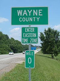 Wayne County is on Eastern Time; however, its western border, shared with Clinton and Russell Counties, is part of the Eastern/Central time zone boundary, as is its southern border with Pickett County, TN. Wayne County was on Central time until October 2000; an account of this change is documented in an article by Dr. Stanley Brunn of the University of Kentucky.
It has the tz database zone identifier America/Kentucky/Monticello
.
of 2000, there were 19,923 people, 7,913 households, and 5,808 families residing in the county. The population density
was 43 /sqmi. There were 9,789 housing units at an average density of 21 /sqmi. The racial makeup of the county was 96.98% White
, 1.49% Black
or African American
, 0.18% Native American
, 0.11% Asian
, 0.47% from other races
, and 0.78% from two or more races. 1.46% of the population were Hispanic
or Latino
of any race.
There were 7,913 households out of which 33.40% had children under the age of 18 living with them, 58.90% were married couples
living together, 10.60% had a female householder with no husband present, and 26.60% were non-families. 23.90% of all households were made up of individuals and 10.40% had someone living alone who was 65 years of age or older. The average household size was 2.49 and the average family size was 2.94.
In the county the population was spread out with 25.30% under the age of 18, 8.90% from 18 to 24, 28.10% from 25 to 44, 24.00% from 45 to 64, and 13.60% who were 65 years of age or older. The median age was 37 years. For every 100 females there were 97.80 males. For every 100 females age 18 and over, there were 94.90 males.
The median income for a household in the county was $20,863, and the median income for a family was $24,869. Males had a median income of $24,021 versus $18,102 for females. The per capita income
for the county was $12,601. About 24.60% of families and 29.40% of the population were below the poverty line, including 34.90% of those under age 18 and 31.50% of those age 65 or over.
U.S. state
A U.S. state is any one of the 50 federated states of the United States of America that share sovereignty with the federal government. Because of this shared sovereignty, an American is a citizen both of the federal entity and of his or her state of domicile. Four states use the official title of...
of Kentucky
Kentucky
The Commonwealth of Kentucky is a state located in the East Central United States of America. As classified by the United States Census Bureau, Kentucky is a Southern state, more specifically in the East South Central region. Kentucky is one of four U.S. states constituted as a commonwealth...
. As of 2000, the population was 19,923. Its county seat
County seat
A county seat is an administrative center, or seat of government, for a county or civil parish. The term is primarily used in the United States....
is Monticello
Monticello, Kentucky
Monticello is a city in Wayne County, Kentucky, United States. The population was 5,981 at the 2000 census. It is the county seat of Wayne County. It advertises itself as "The Houseboat Capital of the World" due to the large number of houseboat manufacturers in the city...
. The county was named for Gen. Anthony Wayne
Anthony Wayne
Anthony Wayne was a United States Army general and statesman. Wayne adopted a military career at the outset of the American Revolutionary War, where his military exploits and fiery personality quickly earned him a promotion to the rank of brigadier general and the sobriquet of Mad Anthony.-Early...
. It is a prohibition or dry county
Dry county
A dry county is a county in the United States whose government forbids the sale of alcoholic beverages. Some prohibit off-premises sale, some prohibit on-premises sale, and some prohibit both. Hundreds of dry counties exist across the United States, almost all of them in the South...
.
History
Wayne County was formed December 13, 1800 from PulaskiPulaski County, Kentucky
Pulaski County is a county located in the U.S. state of Kentucky. The population was 63,063 in the 2010 Census. Its county seat is Somerset6. The county is named for Count Kazimierz Pułaski. Most of the county is a prohibition or dry county...
and Cumberland
Cumberland County, Kentucky
Cumberland County is a county located in the state of Kentucky in the United States. It was formed in 1799. As of 2000, the population was 7,147. Its county seat is Burkesville, Kentucky...
Counties. It was the 43rd county and is named for General "Mad Anthony" Wayne
Anthony Wayne
Anthony Wayne was a United States Army general and statesman. Wayne adopted a military career at the outset of the American Revolutionary War, where his military exploits and fiery personality quickly earned him a promotion to the rank of brigadier general and the sobriquet of Mad Anthony.-Early...
.
Geography
The county's elevation ranges from 723 feet (220.4 m) to 1788 feet (545 m), at the Monticello/Wayne County Airport the elevation is 963 feet (293.5 m). Wayne County is located in the Pennyrile Plateau
Pennyroyal Plateau
The Pennyroyal Plateau, or, as it is more commonly called in Kentucky, the Pennyrile, is a large area of the state that features rolling hills, caves, and karst topography in general. It is also called the "Mississippi Plateau"....
(image) and Eastern Coal Field (image) regions of Kentucky.
Adjacent counties
- Russell CountyRussell County, KentuckyRussell County is a county located in the U.S. state of Kentucky. The population was 17,565 in the 2010 Census. Its county seat is Jamestown. The county is named for William Russell...
(northwest) - Pulaski CountyPulaski County, KentuckyPulaski County is a county located in the U.S. state of Kentucky. The population was 63,063 in the 2010 Census. Its county seat is Somerset6. The county is named for Count Kazimierz Pułaski. Most of the county is a prohibition or dry county...
(northeast) - McCreary CountyMcCreary County, KentuckyMcCreary County is a county located in the U.S. state of Kentucky. As of 2000, the population was 17,080. Its county seat is Whitley City. The county is named for James B. McCreary, a Confederate war hero and Governor of Kentucky from 1875 to 1879. It is the only Kentucky county to not have a...
(east) - Scott County, Tennessee (southeast)
- Pickett County, Tennessee (southwest)
- Clinton CountyClinton County, KentuckyClinton County is a county located in the U.S. state of Kentucky. It was formed in 1836. As of 2000, the population was 9,634. Its name is in honor of the seventh Governor of New York State, DeWitt Clinton. Its county seat is Albany, Kentucky, and it is a prohibition or dry county...
(west)
Time Zone Boundary
It has the tz database zone identifier America/Kentucky/Monticello
America/Kentucky/Monticello
America/Kentucky/Monticello is a time zone identifier from zone file of the tz database. The data is as follows: The reference point is Monticello, Kentucky....
.
Demographics
As of the censusCensus
A census is the procedure of systematically acquiring and recording information about the members of a given population. It is a regularly occurring and official count of a particular population. The term is used mostly in connection with national population and housing censuses; other common...
of 2000, there were 19,923 people, 7,913 households, and 5,808 families residing in the county. The population density
Population density
Population density is a measurement of population per unit area or unit volume. It is frequently applied to living organisms, and particularly to humans...
was 43 /sqmi. There were 9,789 housing units at an average density of 21 /sqmi. The racial makeup of the county was 96.98% White
Race (United States Census)
Race and ethnicity in the United States Census, as defined by the Federal Office of Management and Budget and the United States Census Bureau, are self-identification data items in which residents choose the race or races with which they most closely identify, and indicate whether or not they are...
, 1.49% Black
Race (United States Census)
Race and ethnicity in the United States Census, as defined by the Federal Office of Management and Budget and the United States Census Bureau, are self-identification data items in which residents choose the race or races with which they most closely identify, and indicate whether or not they are...
or African American
Race (United States Census)
Race and ethnicity in the United States Census, as defined by the Federal Office of Management and Budget and the United States Census Bureau, are self-identification data items in which residents choose the race or races with which they most closely identify, and indicate whether or not they are...
, 0.18% Native American
Race (United States Census)
Race and ethnicity in the United States Census, as defined by the Federal Office of Management and Budget and the United States Census Bureau, are self-identification data items in which residents choose the race or races with which they most closely identify, and indicate whether or not they are...
, 0.11% Asian
Race (United States Census)
Race and ethnicity in the United States Census, as defined by the Federal Office of Management and Budget and the United States Census Bureau, are self-identification data items in which residents choose the race or races with which they most closely identify, and indicate whether or not they are...
, 0.47% from other races
Race (United States Census)
Race and ethnicity in the United States Census, as defined by the Federal Office of Management and Budget and the United States Census Bureau, are self-identification data items in which residents choose the race or races with which they most closely identify, and indicate whether or not they are...
, and 0.78% from two or more races. 1.46% of the population were Hispanic
Race (United States Census)
Race and ethnicity in the United States Census, as defined by the Federal Office of Management and Budget and the United States Census Bureau, are self-identification data items in which residents choose the race or races with which they most closely identify, and indicate whether or not they are...
or Latino
Race (United States Census)
Race and ethnicity in the United States Census, as defined by the Federal Office of Management and Budget and the United States Census Bureau, are self-identification data items in which residents choose the race or races with which they most closely identify, and indicate whether or not they are...
of any race.
There were 7,913 households out of which 33.40% had children under the age of 18 living with them, 58.90% were married couples
Marriage
Marriage is a social union or legal contract between people that creates kinship. It is an institution in which interpersonal relationships, usually intimate and sexual, are acknowledged in a variety of ways, depending on the culture or subculture in which it is found...
living together, 10.60% had a female householder with no husband present, and 26.60% were non-families. 23.90% of all households were made up of individuals and 10.40% had someone living alone who was 65 years of age or older. The average household size was 2.49 and the average family size was 2.94.
In the county the population was spread out with 25.30% under the age of 18, 8.90% from 18 to 24, 28.10% from 25 to 44, 24.00% from 45 to 64, and 13.60% who were 65 years of age or older. The median age was 37 years. For every 100 females there were 97.80 males. For every 100 females age 18 and over, there were 94.90 males.
The median income for a household in the county was $20,863, and the median income for a family was $24,869. Males had a median income of $24,021 versus $18,102 for females. The per capita income
Per capita income
Per capita income or income per person is a measure of mean income within an economic aggregate, such as a country or city. It is calculated by taking a measure of all sources of income in the aggregate and dividing it by the total population...
for the county was $12,601. About 24.60% of families and 29.40% of the population were below the poverty line, including 34.90% of those under age 18 and 31.50% of those age 65 or over.
Cities and towns
- MonticelloMonticello, KentuckyMonticello is a city in Wayne County, Kentucky, United States. The population was 5,981 at the 2000 census. It is the county seat of Wayne County. It advertises itself as "The Houseboat Capital of the World" due to the large number of houseboat manufacturers in the city...
- ParmleysvilleParmleysville, KentuckyParmleysville is an unincorporated community in Wayne County, Kentucky, United States. It lies approximately 14 miles southeast of the county seat of Monticello along the banks of the Little South Fork of the Cumberland River.-References:...
- Powersburg, Kentucky
- Sunnybrook, Kentucky
- Windy, Kentucky
- Barrier, Kentucky
- Rocky Branch, Kentucky
- Big Sinkin, Kentucky
- Frazier, Kentucky
- Alpha, KentuckyAlpha, KentuckyAlpha is an unincorporated community in Clinton County, Kentucky, United States. It lies along Route 90 northeast of the city of Albany, the county seat of Clinton County. Its elevation is 1,014 feet , and it is located at . Although it is unincorporated, it has a post office, with the ZIP...
- Cooper, Kentucky
- Roger's Grove, Kentucky
- Duncan Valley, Kentucky
See also
- National Register of Historic Places listings in Wayne County, Kentucky
External links
- Wayne County History
- County History
- Wayne County Historical Museum
- Battle of Mill Springs
- Wayne County KYGenWeb Site
- General
- School Systems