
Sullivan County, Pennsylvania
Encyclopedia
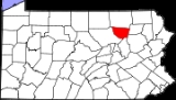
Sullivan County is a county
located in the U.S. state
of Pennsylvania
. As of 2010, the population is 6,428. Sullivan County was created on March 15, 1847, from part of Lycoming County
and named for Charles Sullivan, leader of the Pennsylvania Senate. Its county seat
is Laporte
.
by the Province of Pennsylvania
in 1768, as part of the first Treaty of Fort Stanwix
. It was then part of Northumberland County
, then became part of Lycoming County
when it was formed in 1795. Sullivan County itself was formed from the northeastern part of Lycoming County on March 15, 1847. It was the thirteenth and last county formed at least partly from Lycoming County (and the fifth entirely formed from it).
According to the official state publication Pennsylvania Local Government, Sullivan County was named for Pennsylvania state senator Charles C. Sullivan, who "took an active part in procuring passage of the bill" establishing the county. However, according to Frederic A. Godcharles
(1933), the county is named for General John Sullivan
, who led the Sullivan Expedition
against the Iroquois in 1779.
, the county has a total area of 452 square miles (1,172 km²), of which 450 square miles (1,165 km²) is land and 2 square miles (6 km²) (0.53%) is water.
Elevation ranges from 2593 ft at North Mountain in Davidson Township to 779 ft on Loyalsock Creek
at the Lycoming County line.
physiographic province
, which is characterized by gently folded
and faulted sedimentary rock
s of middle to late Paleozoic
age. The southern border of the county is approximately at the Allegheny Front
, a geological boundary between the Ridge and Valley
province and the plateau. (PA Geologic Survey Map 13)
 The stratigraphic record
of sedimentary rocks within the county spans from the Devonian
Lock Haven Formation
(exposed only in Lick Creek valley) to the coal-bearing Pennsylvanian
Allegheny Formation
. Generally, the Catskill Formation underlies most of the lowlands, and sandstones of the Huntley Mountain
, Burgoon
, Mauch Chunk
, or Pottsville Formation
s cap the mountains. No igneous
or metamorphic
rocks exist within the county, other than possible glacial erratic
s.
Structurally
, the bedrock of Sullivan County is gently folded
, with the axes of two major anticline
s (including the Wilmot Anticline) and two major syncline
s (Bernice-Mehoopany Syncline and Noxen Syncline) each trending roughly east-west. There are three mapped faults in the Allegheny Formation between the towns of Murray and Ringdale.
Nearly all of Sullivan County was glaciated
several times in the past, during the Pleistocene
epoch, or "Ice Age." (PA Geologic Survey Map 59). Most of the county is covered by glacial till
of Late Wisconsinan age. Late Illinoian Stage deposits may underlie the Late Wisconsinan deposits, and these are exposed in the south central part of the county (roughly western Davidson Township).
The major rivers in Sullivan County are Loyalsock Creek
and Muncy Creek
. Both flow into the West Branch of the Susquehanna River
. Some streams along the eastern border of the county flow into the North Branch of the Susquehanna River
. All of Sullivan county is thus within the Chesapeake Bay
Watershed.
Several small coal
fields exist within Sullivan County. (PA Geologic Survey Map 11). The fields contain either bituminous coal or semi-anthracite, and all occur within Pennsylvanian
strata.
Interesting geologic features within Sullivan County include some of the following:
There are several festivities held in the county each year.
Dushore Founder's Day- Held in August. Activities such as Outhouse Races, Roll-a-Keg Races, Arts and Crafts, and vendors.
Dushore Dairy Parade- Held in Mid-June. Activities such as Milking a Cow.
Laporte Fireman's Carnival- Held in August. Carnival rides and games.
Sullivan County Fair- Held in Late August and Early September. Carnival rides and games, exhibitions, competitions, Demolition Derby, and vendors.
 Sullivan County is also home to a large, private hunting club, Painter Den, Inc. This vast property is situated in Davidson, Laporte and Colley townships. Painter Den pond is also on the property and is stocked with Perch and Pike.
}}
As of the census
of 2000, there were 6,556 people, 2,660 households, and 1,752 families residing in the county. The population density
was 15 people per square mile (6/km²). There were 6,017 housing units at an average density of 13 per square mile (5/km²). The racial makeup of the county was 95.58% White
, 2.20% Black
or African American
, 0.76% Native American
, 0.15% Asian
, 0.46% from other races
, and 0.85% from two or more races. 1.10% of the population were Hispanic
or Latino
of any race. 33.8% were of German, 14.7% Irish
, 9.5% English
, 7.5% American
, 5.9% Polish and 5.6% Italian
ancestry according to Census 2000.
There were 2,660 households out of which 24.20% had children under the age of 18 living with them, 54.70% were married couples
living together, 6.80% had a female householder with no husband present, and 34.10% were non-families. 29.30% of all households were made up of individuals and 15.20% had someone living alone who was 65 years of age or older. The average household size was 2.30 and the average family size was 2.81.
In the county, the population was spread out with 20.80% under the age of 18, 7.90% from 18 to 24, 24.10% from 25 to 44, 25.30% from 45 to 64, and 21.90% who were 65 years of age or older. The median age was 43 years. For every 100 females there were 102.10 males. For every 100 females age 18 and over, there were 100.40 males.
 Under Pennsylvania law, there are four types of incorporated municipalities: cities, boroughs, townships, and, in at most two cases, towns. The following cities, boroughs and townships are located in Sullivan County:
Sullivan County School District has one high school, grades 7-12, and two elementary schools, grades K-6. Sullivan County High School is located in Laporte, PA
. Sullivan County Elementary School is located just behind the high school.
.
County (United States)
In the United States, a county is a geographic subdivision of a state , usually assigned some governmental authority. The term "county" is used in 48 of the 50 states; Louisiana is divided into parishes and Alaska into boroughs. Parishes and boroughs are called "county-equivalents" by the U.S...
located in the U.S. state
U.S. state
A U.S. state is any one of the 50 federated states of the United States of America that share sovereignty with the federal government. Because of this shared sovereignty, an American is a citizen both of the federal entity and of his or her state of domicile. Four states use the official title of...
of Pennsylvania
Pennsylvania
The Commonwealth of Pennsylvania is a U.S. state that is located in the Northeastern and Mid-Atlantic regions of the United States. The state borders Delaware and Maryland to the south, West Virginia to the southwest, Ohio to the west, New York and Ontario, Canada, to the north, and New Jersey to...
. As of 2010, the population is 6,428. Sullivan County was created on March 15, 1847, from part of Lycoming County
Lycoming County, Pennsylvania
-Appalachian Mountains and Allegheny Plateau:Lycoming County is divided between the Appalachian Mountains in the south, the dissected Allegheny Plateau in the north and east, and the valley of the West Branch Susquehanna River between these.-West Branch Susquehanna River:The West Branch of the...
and named for Charles Sullivan, leader of the Pennsylvania Senate. Its county seat
County seat
A county seat is an administrative center, or seat of government, for a county or civil parish. The term is primarily used in the United States....
is Laporte
Laporte, Pennsylvania
Laporte is a borough in Sullivan County, Pennsylvania, United States. The population was 316 at the 2010 census. It is the county seat of Sullivan County. Laporte is surrounded by Laporte Township. It was named for John Laporte...
.
History
The land which became Sullivan County was originally purchased from the IroquoisIroquois
The Iroquois , also known as the Haudenosaunee or the "People of the Longhouse", are an association of several tribes of indigenous people of North America...
by the Province of Pennsylvania
Province of Pennsylvania
The Province of Pennsylvania, also known as Pennsylvania Colony, was founded in British America by William Penn on March 4, 1681 as dictated in a royal charter granted by King Charles II...
in 1768, as part of the first Treaty of Fort Stanwix
Treaty of Fort Stanwix
The Treaty of Fort Stanwix was an important treaty between North American Indians and the British Empire. It was signed in 1768 at Fort Stanwix, located in present-day Rome, New York...
. It was then part of Northumberland County
Northumberland County, Pennsylvania
There were 38,835 households out of which 27.30% had children under the age of 18 living with them, 52.40% were married couples living together, 9.60% had a female householder with no husband present, and 34.10% were non-families. 30.20% of all households were made up of individuals and 15.50% had...
, then became part of Lycoming County
Lycoming County, Pennsylvania
-Appalachian Mountains and Allegheny Plateau:Lycoming County is divided between the Appalachian Mountains in the south, the dissected Allegheny Plateau in the north and east, and the valley of the West Branch Susquehanna River between these.-West Branch Susquehanna River:The West Branch of the...
when it was formed in 1795. Sullivan County itself was formed from the northeastern part of Lycoming County on March 15, 1847. It was the thirteenth and last county formed at least partly from Lycoming County (and the fifth entirely formed from it).
According to the official state publication Pennsylvania Local Government, Sullivan County was named for Pennsylvania state senator Charles C. Sullivan, who "took an active part in procuring passage of the bill" establishing the county. However, according to Frederic A. Godcharles
Frederic A. Godcharles
Frederic Antes Godcharles was a Pennsylvania politician, historian and author, who served as soldier and as director of the State Library of Pennsylvania and State Museum of Pennsylvania.-Personal life:...
(1933), the county is named for General John Sullivan
John Sullivan
John Sullivan was the third son of Irish immigrants, a United States general in the Revolutionary War, a delegate in the Continental Congress and a United States federal judge....
, who led the Sullivan Expedition
Sullivan Expedition
The Sullivan Expedition, also known as the Sullivan-Clinton Expedition, was an American campaign led by Major General John Sullivan and Brigadier General James Clinton against Loyalists and the four nations of the Iroquois who had sided with the British in the American Revolutionary War.The...
against the Iroquois in 1779.
Geography
According to the U.S. Census BureauUnited States Census Bureau
The United States Census Bureau is the government agency that is responsible for the United States Census. It also gathers other national demographic and economic data...
, the county has a total area of 452 square miles (1,172 km²), of which 450 square miles (1,165 km²) is land and 2 square miles (6 km²) (0.53%) is water.
Elevation ranges from 2593 ft at North Mountain in Davidson Township to 779 ft on Loyalsock Creek
Loyalsock Creek
Loyalsock Creek is a tributary of the West Branch Susquehanna River located chiefly in Sullivan and Lycoming counties in Pennsylvania in the United States...
at the Lycoming County line.
Adjacent counties
- Bradford CountyBradford County, Pennsylvania-Demographics:As of the census of 2000, there were 62,761 people, 24,453 households, and 17,312 families residing in the county. The population density was 54 people per square mile . There were 28,664 housing units at an average density of 25 per square mile...
(north) - Wyoming CountyWyoming County, PennsylvaniaWyoming County is a county located in the U.S. state of Pennsylvania. It was created in 1842 from part of Luzerne County. Its county seat is Tunkhannock.-Geography:According to the U.S...
(east) - Luzerne CountyLuzerne County, Pennsylvania- Demographics :As of the 2010 census, the county was 90.7% White, 3.4% Black or African American, 0.2% Native American, 1.0% Asian, 3.3% were of some other race, and 1.5% were two or more races. 6.7% of the population was of Hispanic or Latino ancestry...
(southeast) - Columbia CountyColumbia County, PennsylvaniaAs of the census of 2000, there were 64,151 people, 24,915 households, and 16,568 families residing in the county. The population density was 132 people per square mile . There were 27,733 housing units at an average density of 57 per square mile...
(south) - Lycoming CountyLycoming County, Pennsylvania-Appalachian Mountains and Allegheny Plateau:Lycoming County is divided between the Appalachian Mountains in the south, the dissected Allegheny Plateau in the north and east, and the valley of the West Branch Susquehanna River between these.-West Branch Susquehanna River:The West Branch of the...
(west)
Geology
Sullivan County lies predominantly within the Appalachian PlateauAppalachian Plateau
The Appalachian Plateau is the western part of the Appalachian mountains, stretching from New York and Alabama. The plateau is a second level United States physiographic region....
physiographic province
United States physiographic region
The list of continental United States Physiographic regions identifies the 8 regions, 25 provinces, and 85 sections. The system dates to Nevin Fenneman's paper Physiographic Subdivision of the United States, published in 1917...
, which is characterized by gently folded
Fold (geology)
The term fold is used in geology when one or a stack of originally flat and planar surfaces, such as sedimentary strata, are bent or curved as a result of permanent deformation. Synsedimentary folds are those due to slumping of sedimentary material before it is lithified. Folds in rocks vary in...
and faulted sedimentary rock
Sedimentary rock
Sedimentary rock are types of rock that are formed by the deposition of material at the Earth's surface and within bodies of water. Sedimentation is the collective name for processes that cause mineral and/or organic particles to settle and accumulate or minerals to precipitate from a solution....
s of middle to late Paleozoic
Paleozoic
The Paleozoic era is the earliest of three geologic eras of the Phanerozoic eon, spanning from roughly...
age. The southern border of the county is approximately at the Allegheny Front
Allegheny Front
The Allegheny Front is the major southeast- or east-facing escarpment in the Allegheny Mountains in southern Pennsylvania, western Maryland, and eastern West Virginia, USA. The Allegheny Front delineates the Ridge-and-Valley Appalachians to its east from the Appalachian Plateau to its west...
, a geological boundary between the Ridge and Valley
Ridge-and-valley Appalachians
The Ridge-and-Valley Appalachians, also called the Ridge and Valley Province or the Valley and Ridge Appalachians, are a physiographic province of the larger Appalachian division and are also a belt within the Appalachian Mountains extending from southeastern New York through northwestern New...
province and the plateau. (PA Geologic Survey Map 13)
Stratigraphy
Stratigraphy, a branch of geology, studies rock layers and layering . It is primarily used in the study of sedimentary and layered volcanic rocks....
of sedimentary rocks within the county spans from the Devonian
Devonian
The Devonian is a geologic period and system of the Paleozoic Era spanning from the end of the Silurian Period, about 416.0 ± 2.8 Mya , to the beginning of the Carboniferous Period, about 359.2 ± 2.5 Mya...
Lock Haven Formation
Lock Haven Formation
The Lock Haven Formation is a Devonian mapped bedrock unit in Pennsylvania, in the Appalachian Mountains of the United States.-Description:The Lock Haven is gray to green-brown sandstone, siltstone, and shale and is over 400 million years old...
(exposed only in Lick Creek valley) to the coal-bearing Pennsylvanian
Pennsylvanian
The Pennsylvanian is, in the ICS geologic timescale, the younger of two subperiods of the Carboniferous Period. It lasted from roughly . As with most other geochronologic units, the rock beds that define the Pennsylvanian are well identified, but the exact date of the start and end are uncertain...
Allegheny Formation
Allegheny Formation
The Pennsylvanian Allegheny Formation is a mapped bedrock unit in western and central Pennsylvania, western Maryland and West Virginia, and southeastern Ohio...
. Generally, the Catskill Formation underlies most of the lowlands, and sandstones of the Huntley Mountain
Huntley Mountain Formation
The Huntley Mountain Formation is a late Devonian and early Mississippian mapped bedrock unit in Pennsylvania, in the United States.-Description:The formation is composed of relatively soft grayish-red shale and olive-gray sandstone...
, Burgoon
Pocono Formation
The Mississippian Pocono Formation is a mapped bedrock unit in Pennsylvania, Maryland, and West Virginia, USA. It is also known as the Pocono Group in Maryland and West Virginia,...
, Mauch Chunk
Mauch Chunk Formation
The Mississippian Mauch Chunk Formation is a mapped bedrock unit in Pennsylvania, Maryland, and West Virginia. It is named for the borough of Mauch Chunk, now known as Jim Thorpe, Pennsylvania.-Description:...
, or Pottsville Formation
Pottsville Formation
The Pennsylvanian Pottsville Formation is a mapped bedrock unit in Pennsylvania, western Maryland, West Virginia, and Ohio. The formation is also recognized in Alabama. It is a major ridge-former In the Ridge-and-Valley Appalachians of the eastern United States...
s cap the mountains. No igneous
Igneous rock
Igneous rock is one of the three main rock types, the others being sedimentary and metamorphic rock. Igneous rock is formed through the cooling and solidification of magma or lava...
or metamorphic
Metamorphic rock
Metamorphic rock is the transformation of an existing rock type, the protolith, in a process called metamorphism, which means "change in form". The protolith is subjected to heat and pressure causing profound physical and/or chemical change...
rocks exist within the county, other than possible glacial erratic
Glacial erratic
A glacial erratic is a piece of rock that differs from the size and type of rock native to the area in which it rests. "Erratics" take their name from the Latin word errare, and are carried by glacial ice, often over distances of hundreds of kilometres...
s.
Structurally
Structural geology
Structural geology is the study of the three-dimensional distribution of rock units with respect to their deformational histories. The primary goal of structural geology is to use measurements of present-day rock geometries to uncover information about the history of deformation in the rocks, and...
, the bedrock of Sullivan County is gently folded
Fold (geology)
The term fold is used in geology when one or a stack of originally flat and planar surfaces, such as sedimentary strata, are bent or curved as a result of permanent deformation. Synsedimentary folds are those due to slumping of sedimentary material before it is lithified. Folds in rocks vary in...
, with the axes of two major anticline
Anticline
In structural geology, an anticline is a fold that is convex up and has its oldest beds at its core. The term is not to be confused with antiform, which is a purely descriptive term for any fold that is convex up. Therefore if age relationships In structural geology, an anticline is a fold that is...
s (including the Wilmot Anticline) and two major syncline
Syncline
In structural geology, a syncline is a fold, with younger layers closer to the center of the structure. A synclinorium is a large syncline with superimposed smaller folds. Synclines are typically a downward fold, termed a synformal syncline In structural geology, a syncline is a fold, with younger...
s (Bernice-Mehoopany Syncline and Noxen Syncline) each trending roughly east-west. There are three mapped faults in the Allegheny Formation between the towns of Murray and Ringdale.
Nearly all of Sullivan County was glaciated
Glacier
A glacier is a large persistent body of ice that forms where the accumulation of snow exceeds its ablation over many years, often centuries. At least 0.1 km² in area and 50 m thick, but often much larger, a glacier slowly deforms and flows due to stresses induced by its weight...
several times in the past, during the Pleistocene
Pleistocene
The Pleistocene is the epoch from 2,588,000 to 11,700 years BP that spans the world's recent period of repeated glaciations. The name pleistocene is derived from the Greek and ....
epoch, or "Ice Age." (PA Geologic Survey Map 59). Most of the county is covered by glacial till
Till
thumb|right|Closeup of glacial till. Note that the larger grains in the till are completely surrounded by the matrix of finer material , and this characteristic, known as matrix support, is diagnostic of till....
of Late Wisconsinan age. Late Illinoian Stage deposits may underlie the Late Wisconsinan deposits, and these are exposed in the south central part of the county (roughly western Davidson Township).
The major rivers in Sullivan County are Loyalsock Creek
Loyalsock Creek
Loyalsock Creek is a tributary of the West Branch Susquehanna River located chiefly in Sullivan and Lycoming counties in Pennsylvania in the United States...
and Muncy Creek
Muncy Creek
Muncy Creek is a tributary of the West Branch Susquehanna River in Lycoming and Sullivan counties, Pennsylvania, USA. Little Muncy Creek is its major tributary.-Course:The creek is long. For much of its length, U.S. Route 220 runs parallel to Muncy Creek....
. Both flow into the West Branch of the Susquehanna River
West Branch Susquehanna River
The West Branch Susquehanna River is one of the two principal branches, along with the North Branch, of the Susquehanna River in the northeastern United States. The North Branch, which rises in upstate New York, is generally regarded as the extension of the main branch, with the shorter West Branch...
. Some streams along the eastern border of the county flow into the North Branch of the Susquehanna River
Susquehanna River
The Susquehanna River is a river located in the northeastern United States. At long, it is the longest river on the American east coast that drains into the Atlantic Ocean, and with its watershed it is the 16th largest river in the United States, and the longest river in the continental United...
. All of Sullivan county is thus within the Chesapeake Bay
Chesapeake Bay
The Chesapeake Bay is the largest estuary in the United States. It lies off the Atlantic Ocean, surrounded by Maryland and Virginia. The Chesapeake Bay's drainage basin covers in the District of Columbia and parts of six states: New York, Pennsylvania, Delaware, Maryland, Virginia, and West...
Watershed.
Several small coal
Coal
Coal is a combustible black or brownish-black sedimentary rock usually occurring in rock strata in layers or veins called coal beds or coal seams. The harder forms, such as anthracite coal, can be regarded as metamorphic rock because of later exposure to elevated temperature and pressure...
fields exist within Sullivan County. (PA Geologic Survey Map 11). The fields contain either bituminous coal or semi-anthracite, and all occur within Pennsylvanian
Pennsylvanian
The Pennsylvanian is, in the ICS geologic timescale, the younger of two subperiods of the Carboniferous Period. It lasted from roughly . As with most other geochronologic units, the rock beds that define the Pennsylvanian are well identified, but the exact date of the start and end are uncertain...
strata.
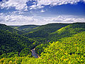
Interesting geologic features within Sullivan County include some of the following:
- The Haystacks (Huntley Mountain FormationHuntley Mountain FormationThe Huntley Mountain Formation is a late Devonian and early Mississippian mapped bedrock unit in Pennsylvania, in the United States.-Description:The formation is composed of relatively soft grayish-red shale and olive-gray sandstone...
), exposed along Loyalsock CreekLoyalsock CreekLoyalsock Creek is a tributary of the West Branch Susquehanna River located chiefly in Sullivan and Lycoming counties in Pennsylvania in the United States...
south of DushoreDushore, PennsylvaniaDushore is a borough in Sullivan County, Pennsylvania, in the United States. The population was 608 at the 2010 census. Dushore is home to Sullivan County's only traffic light.-Geography:Dushore is located at ....
, are sandstoneSandstoneSandstone is a sedimentary rock composed mainly of sand-sized minerals or rock grains.Most sandstone is composed of quartz and/or feldspar because these are the most common minerals in the Earth's crust. Like sand, sandstone may be any colour, but the most common colours are tan, brown, yellow,...
mounds of unknown origin - Ganoga LakeGanoga LakeGanoga Lake is a natural lake in Colley Township in southeast Sullivan County in Pennsylvania, United States. Known as Robinson's Lake and Long Pond for most of the 19th century, the lake was purchased by the Ricketts family in the early 1850s and became part of R. Bruce Ricketts' extensive...
is the state's highest lake at 2265 ft above sea level - Ricketts Glen State ParkRicketts Glen State ParkRicketts Glen State Park is a Pennsylvania state park on in Columbia, Luzerne, and Sullivan counties in Pennsylvania in the United States. Ricketts Glen is a National Natural Landmark known for its old-growth forest and 24 named waterfalls along Kitchen Creek, which flows down the Allegheny...
, with its many waterfalls - Worlds End State ParkWorlds End State ParkWorlds End State Park is a Pennsylvania state park in Sullivan County, Pennsylvania, in the United States. The park, nearly surrounded by Loyalsock State Forest, is in the Loyalsock Creek valley on Pennsylvania Route 154, in Forks and Shrewsbury Townships just east of the borough of Forksville....
, including an exposure of the Huntley Mountain FormationHuntley Mountain FormationThe Huntley Mountain Formation is a late Devonian and early Mississippian mapped bedrock unit in Pennsylvania, in the United States.-Description:The formation is composed of relatively soft grayish-red shale and olive-gray sandstone...
, and a "rock city" where cross-beddingCross-beddingIn geology, the sedimentary structures known as cross-bedding refer to horizontal units that are internally composed of inclined layers. This is a case in geology in which the original depositional layering is tilted, and the tilting is not a result of post-depositional deformation...
is visible in the sandstone of the Pottsville FormationPottsville FormationThe Pennsylvanian Pottsville Formation is a mapped bedrock unit in Pennsylvania, western Maryland, West Virginia, and Ohio. The formation is also recognized in Alabama. It is a major ridge-former In the Ridge-and-Valley Appalachians of the eastern United States... - The Leberfinger QuarryQuarryA quarry is a type of open-pit mine from which rock or minerals are extracted. Quarries are generally used for extracting building materials, such as dimension stone, construction aggregate, riprap, sand, and gravel. They are often collocated with concrete and asphalt plants due to the requirement...
(on Millview Mountain Rd northeast of ForksvilleForksville, PennsylvaniaForksville is a borough in Sullivan County, Pennsylvania, United States. The population was 145 at the 2010 census. It is the home of the 150 year old Forksville General Store, down the road from the Sullivan County Fairgrounds, and near Worlds End State Park...
), in the Lock Haven FormationLock Haven FormationThe Lock Haven Formation is a Devonian mapped bedrock unit in Pennsylvania, in the Appalachian Mountains of the United States.-Description:The Lock Haven is gray to green-brown sandstone, siltstone, and shale and is over 400 million years old...
where brachiopodBrachiopodBrachiopods are a phylum of marine animals that have hard "valves" on the upper and lower surfaces, unlike the left and right arrangement in bivalve molluscs. Brachiopod valves are hinged at the rear end, while the front can be opened for feeding or closed for protection...
fossilFossilFossils are the preserved remains or traces of animals , plants, and other organisms from the remote past...
s, trace fossilsIchnologyIchnology is the branch of geology that deals with traces of organismal behavior, such as burrows and footprints. It is generally considered as a branch of paleontology; however, only one division of ichnology, paleoichnology, deals with trace fossils, while neoichnology is the study of modern traces...
, and plant fossils can be observed - Grand View, located at the southeast corner of the county on a knob of Red Rock Mountain, provides scenic views of the Allegheny FrontAllegheny FrontThe Allegheny Front is the major southeast- or east-facing escarpment in the Allegheny Mountains in southern Pennsylvania, western Maryland, and eastern West Virginia, USA. The Allegheny Front delineates the Ridge-and-Valley Appalachians to its east from the Appalachian Plateau to its west...
- Ticklish RockTicklish RockTicklish Rock is an unusual sandstone rock formation. located in Shrewsbury Township, Sullivan County, Pennsylvania. The brown and green sandstone formation, which stands at the edge of a steep cliff and resembles an upright hammer, consists of a large horizontal block, 3 feet high, 8 feet long,...
, located near Glen Mawr up Rock Run Road, features a rock formation of the DevonianDevonianThe Devonian is a geologic period and system of the Paleozoic Era spanning from the end of the Silurian Period, about 416.0 ± 2.8 Mya , to the beginning of the Carboniferous Period, about 359.2 ± 2.5 Mya...
Catskill Formation.
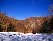
Recreation
There are two Pennsylvania state parks in Sullivan County.- Part of Ricketts Glen State ParkRicketts Glen State ParkRicketts Glen State Park is a Pennsylvania state park on in Columbia, Luzerne, and Sullivan counties in Pennsylvania in the United States. Ricketts Glen is a National Natural Landmark known for its old-growth forest and 24 named waterfalls along Kitchen Creek, which flows down the Allegheny...
is in the eastern portion of the county. - Worlds End State ParkWorlds End State ParkWorlds End State Park is a Pennsylvania state park in Sullivan County, Pennsylvania, in the United States. The park, nearly surrounded by Loyalsock State Forest, is in the Loyalsock Creek valley on Pennsylvania Route 154, in Forks and Shrewsbury Townships just east of the borough of Forksville....
is near ForksvilleForksville, PennsylvaniaForksville is a borough in Sullivan County, Pennsylvania, United States. The population was 145 at the 2010 census. It is the home of the 150 year old Forksville General Store, down the road from the Sullivan County Fairgrounds, and near Worlds End State Park...
on Loyalsock CreekLoyalsock CreekLoyalsock Creek is a tributary of the West Branch Susquehanna River located chiefly in Sullivan and Lycoming counties in Pennsylvania in the United States...
There are several festivities held in the county each year.
Dushore Founder's Day- Held in August. Activities such as Outhouse Races, Roll-a-Keg Races, Arts and Crafts, and vendors.
Dushore Dairy Parade- Held in Mid-June. Activities such as Milking a Cow.
Laporte Fireman's Carnival- Held in August. Carnival rides and games.
Sullivan County Fair- Held in Late August and Early September. Carnival rides and games, exhibitions, competitions, Demolition Derby, and vendors.
Demographics
| footnote= Sullivan County Census Data}}
As of the census
Census
A census is the procedure of systematically acquiring and recording information about the members of a given population. It is a regularly occurring and official count of a particular population. The term is used mostly in connection with national population and housing censuses; other common...
of 2000, there were 6,556 people, 2,660 households, and 1,752 families residing in the county. The population density
Population density
Population density is a measurement of population per unit area or unit volume. It is frequently applied to living organisms, and particularly to humans...
was 15 people per square mile (6/km²). There were 6,017 housing units at an average density of 13 per square mile (5/km²). The racial makeup of the county was 95.58% White
Race (United States Census)
Race and ethnicity in the United States Census, as defined by the Federal Office of Management and Budget and the United States Census Bureau, are self-identification data items in which residents choose the race or races with which they most closely identify, and indicate whether or not they are...
, 2.20% Black
Race (United States Census)
Race and ethnicity in the United States Census, as defined by the Federal Office of Management and Budget and the United States Census Bureau, are self-identification data items in which residents choose the race or races with which they most closely identify, and indicate whether or not they are...
or African American
Race (United States Census)
Race and ethnicity in the United States Census, as defined by the Federal Office of Management and Budget and the United States Census Bureau, are self-identification data items in which residents choose the race or races with which they most closely identify, and indicate whether or not they are...
, 0.76% Native American
Race (United States Census)
Race and ethnicity in the United States Census, as defined by the Federal Office of Management and Budget and the United States Census Bureau, are self-identification data items in which residents choose the race or races with which they most closely identify, and indicate whether or not they are...
, 0.15% Asian
Race (United States Census)
Race and ethnicity in the United States Census, as defined by the Federal Office of Management and Budget and the United States Census Bureau, are self-identification data items in which residents choose the race or races with which they most closely identify, and indicate whether or not they are...
, 0.46% from other races
Race (United States Census)
Race and ethnicity in the United States Census, as defined by the Federal Office of Management and Budget and the United States Census Bureau, are self-identification data items in which residents choose the race or races with which they most closely identify, and indicate whether or not they are...
, and 0.85% from two or more races. 1.10% of the population were Hispanic
Race (United States Census)
Race and ethnicity in the United States Census, as defined by the Federal Office of Management and Budget and the United States Census Bureau, are self-identification data items in which residents choose the race or races with which they most closely identify, and indicate whether or not they are...
or Latino
Race (United States Census)
Race and ethnicity in the United States Census, as defined by the Federal Office of Management and Budget and the United States Census Bureau, are self-identification data items in which residents choose the race or races with which they most closely identify, and indicate whether or not they are...
of any race. 33.8% were of German, 14.7% Irish
Irish people
The Irish people are an ethnic group who originate in Ireland, an island in northwestern Europe. Ireland has been populated for around 9,000 years , with the Irish people's earliest ancestors recorded having legends of being descended from groups such as the Nemedians, Fomorians, Fir Bolg, Tuatha...
, 9.5% English
English people
The English are a nation and ethnic group native to England, who speak English. The English identity is of early mediaeval origin, when they were known in Old English as the Anglecynn. England is now a country of the United Kingdom, and the majority of English people in England are British Citizens...
, 7.5% American
United States
The United States of America is a federal constitutional republic comprising fifty states and a federal district...
, 5.9% Polish and 5.6% Italian
Italian people
The Italian people are an ethnic group that share a common Italian culture, ancestry and speak the Italian language as a mother tongue. Within Italy, Italians are defined by citizenship, regardless of ancestry or country of residence , and are distinguished from people...
ancestry according to Census 2000.
There were 2,660 households out of which 24.20% had children under the age of 18 living with them, 54.70% were married couples
Marriage
Marriage is a social union or legal contract between people that creates kinship. It is an institution in which interpersonal relationships, usually intimate and sexual, are acknowledged in a variety of ways, depending on the culture or subculture in which it is found...
living together, 6.80% had a female householder with no husband present, and 34.10% were non-families. 29.30% of all households were made up of individuals and 15.20% had someone living alone who was 65 years of age or older. The average household size was 2.30 and the average family size was 2.81.
In the county, the population was spread out with 20.80% under the age of 18, 7.90% from 18 to 24, 24.10% from 25 to 44, 25.30% from 45 to 64, and 21.90% who were 65 years of age or older. The median age was 43 years. For every 100 females there were 102.10 males. For every 100 females age 18 and over, there were 100.40 males.
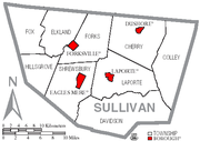
Municipalities
Boroughs
|
Forksville, Pennsylvania Forksville is a borough in Sullivan County, Pennsylvania, United States. The population was 145 at the 2010 census. It is the home of the 150 year old Forksville General Store, down the road from the Sullivan County Fairgrounds, and near Worlds End State Park... Laporte, Pennsylvania Laporte is a borough in Sullivan County, Pennsylvania, United States. The population was 316 at the 2010 census. It is the county seat of Sullivan County. Laporte is surrounded by Laporte Township. It was named for John Laporte... |
Townships
|
Fox Township, Sullivan County, Pennsylvania Fox Township is a township in Sullivan County, Pennsylvania, United States. The population was 332 at the 2000 census.-Geography:According to the United States Census Bureau, the township has a total area of , of which, of it is land and of it is water.Fox Township is bordered by Bradford County... Shrewsbury Township, Sullivan County, Pennsylvania Shrewsbury Township is a township in Sullivan County, Pennsylvania, United States. The population was 328 at the 2000 census.-Geography:According to the United States Census Bureau, the township has a total area of 48.1 square miles , of which, 47.8 square miles of it is land and... |
Public School Districts
- Sullivan County School DistrictSullivan County School DistrictThe Sullivan County School District covers the whole of Sullivan County, Pennsylvania. The district operates Sullivan County High School grades 7-12, Sullivan County Elementary School and Turnpike Elementary School. It encompasses approximately 479 square miles. According to 2000 federal census...
Sullivan County School District has one high school, grades 7-12, and two elementary schools, grades K-6. Sullivan County High School is located in Laporte, PA
Laporte, Pennsylvania
Laporte is a borough in Sullivan County, Pennsylvania, United States. The population was 316 at the 2010 census. It is the county seat of Sullivan County. Laporte is surrounded by Laporte Township. It was named for John Laporte...
. Sullivan County Elementary School is located just behind the high school.
Transportation
Public transportation is provided by Endless Mountains Transportation AuthorityEndless Mountains Transportation Authority
Endless Mountains Transportation Authority is a public transportation provider that features routes in three northwestern Pennsylvania counties. It provides bus and paratransit service for Bradford, Sullivan, and Tioga Counties...
.
See also
- List of municipal authorities in Sullivan County, Pennsylvania
- National Register of Historic Places listings in Sullivan County, PennsylvaniaNational Register of Historic Places listings in Sullivan County, PennsylvaniaThis is a list of the National Register of Historic Places listings in Sullivan County, Pennsylvania.This is intended to be a complete list of the properties and districts on National Register of Historic Places in Sullivan County, Pennsylvania...