

Boyd County, Kentucky
Encyclopedia
Boyd County is a county located in the U.S. state
of Kentucky
. It was formed in 1860. Its 160 square miles (414.4 km²) are found at the northeastern edge of the state the near the Ohio River
and Big Sandy River
, nestled in the verdant rolling hills of Appalachia
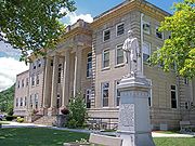
. The county seat is Catlettsburg
. Its largest municipality is the city of Ashland
.
The population was 49,542 in the 2010 Census. Boyd County is a part of the Huntington-Ashland, WV-KY-OH, Metropolitan Statistical Area
(MSA). As of the 2000 census, the MSA had a population of 288,649.
, Carter
, and Lawrence
counties. It was named for Linn Boyd
of Paducah
, former U.S. congressman, Speaker of the United States House of Representatives
, who died in 1859 soon after being elected lieutenant governor of Kentucky.
The earliest evidence of human habitation in Boyd County exists in the forms of numerous earthen mounds containing human skeletons and burial goods giving evidence that prehistoric Native Americans
inhabited the area. A 1973 archeological find revealed a serpent-shaped mound built of rocks dating to 2000 B.C. and stretching for 900 feet (274.3 m) along a ridge parallel to the Big Sandy River
south of Catlettsburg
.
One of the early settlers in what is now Boyd County was Charles ("One-handed Charley") Smith, from Virginia. A veteran of the French and Indian War
who had served under Col. George Washington
in 1754, Smith received for that service roughly 400 acres (1.6 km²) around Chadwicks Creek, where he built a cabin in 1774. Smith died in 1776 and in 1797 this land passed to Alexander Catlett for whom the town of Catlettsburg
is named.
The Poage family arrived from Staunton
, Virginia
, in October 1799 and formed Poage’s Landing, later renamed the city of Ashland
.
side of the Ohio River
, seven of them in present-day Boyd County.
The Kentucky Iron, Coal and Manufacturing Company was incorporated on March 8, 1854, and it laid out the town of Ashland
, then within Greenup County
. The company purchased thousands of acres of coal, timber, and ore lands throughout the county. It invested US$
210,000 in bonds of the Lexington & Big Sandy River Railroad Company, with the stipulation that the eastern division of that line extend into Ashland instead of ending, as originally planned, in Catlettsburg. The early presence of the railroad in Ashland was largely responsible for this city becoming the dominant municipality of the county.
Ashland furnace was sold to American Rolling Mill Company in 1921, which developed into Armco Steel Corporation. In 1963 Armco constructed the Amanda furnace, one of the largest blast furnaces in the world. Known today as AK Steel, the industry remains a major employer in northeastern Kentucky.
Ashland Oil, Inc.
, at one time the largest corporation headquartered in Kentucky, was started in 1924 at Leach Station, south of Catlettsburg
, by Paul G. Blazer. Best known for their Valvoline Oil products, Ashland Oil relocated to Covington
, Kentucky
in 1999, merged with Marathon Oil
, and sold its remaining petroleum shares to Marathon in 2005, dissolving their petroleum division. The original oil refinery, located in Catlettsburg, is still in operation today and is currently owned by Marathon Oil.
 According to the 2000 census, the county has a total area of 161.82 square miles (419.1 km²), of which 160.17 square miles (414.8 km²) (or 98.98%) is land and 1.65 square miles (4.3 km²) (or 1.02%) is water.
, in Ashland, is one of 16 two-year, open-admissions colleges of the Kentucky Community and Technical College System
. Morehead State University
also has a satellite campus located in Ashland.
of 2000, there were 49,752 people, 20,010 households, and 14,107 families residing in the county. The population density
was 311 /sqmi. There were 21,976 housing units at an average density of 137 /sqmi. The racial makeup of the county was 95.97% White
, 2.55% Black
or African American
, 0.16% Native American
, 0.30% Asian
, 0.14% from other races
, and 0.88% from two or more races. 1.12% of the population were Hispanic
or Latino
of any race.
There were 20,010 households out of which 28.90% had children under the age of 18 living with them, 55.70% were married couples
living together, 11.60% had a female householder with no husband present, and 29.50% were non-families. 26.50% of all households were made up of individuals and 12.20% had someone living alone who was 65 years of age or older. The average household size was 2.38 and the average family size was 2.86.
The age distribution was 21.80% under the age of 18, 8.30% from 18 to 24, 28.70% from 25 to 44, 25.60% from 45 to 64, and 15.60% who were 65 years of age or older. The median age was 40 years. For every 100 females there were 96.00 males. For every 100 females age 18 and over, there were 93.10 males.
The median income for a household in the county was $32,749, and the median income for a family was $41,125. Males had a median income of $35,728 versus $22,591 for females. The per capita income
for the county was $18,212. About 11.50% of families and 15.50% of the population were below the poverty line, including 22.40% of those under age 18 and 12.10% of those age 65 or over.
operates the Federal Correctional Institution, Ashland
in Summit, unincorporated
Boyd County, 5 miles (8 km) southwest of Ashland
.
U.S. state
A U.S. state is any one of the 50 federated states of the United States of America that share sovereignty with the federal government. Because of this shared sovereignty, an American is a citizen both of the federal entity and of his or her state of domicile. Four states use the official title of...
of Kentucky
Kentucky
The Commonwealth of Kentucky is a state located in the East Central United States of America. As classified by the United States Census Bureau, Kentucky is a Southern state, more specifically in the East South Central region. Kentucky is one of four U.S. states constituted as a commonwealth...
. It was formed in 1860. Its 160 square miles (414.4 km²) are found at the northeastern edge of the state the near the Ohio River
Ohio River
The Ohio River is the largest tributary, by volume, of the Mississippi River. At the confluence, the Ohio is even bigger than the Mississippi and, thus, is hydrologically the main stream of the whole river system, including the Allegheny River further upstream...
and Big Sandy River
Big Sandy River (Ohio River)
The Big Sandy River is a tributary of the Ohio River, approximately long, in western West Virginia and northeastern Kentucky in the United States. The river forms part of the boundary between the two states along its entire course...
, nestled in the verdant rolling hills of Appalachia
Appalachia
Appalachia is a term used to describe a cultural region in the eastern United States that stretches from the Southern Tier of New York state to northern Alabama, Mississippi, and Georgia. While the Appalachian Mountains stretch from Belle Isle in Canada to Cheaha Mountain in the U.S...
. The county seat is Catlettsburg
Catlettsburg, Kentucky
Catlettsburg is a city in Boyd County, Kentucky, United States and is the county seat of Boyd County. The city population was 1,960 at the 2000 census. The city's postal ZIP code serves a greater population of 10,029, which is a better reflection of the community's size. Catlettsburg is a part of...
. Its largest municipality is the city of Ashland
Ashland, Kentucky
Ashland, formerly known as Poage Settlement, is a city in Boyd County, Kentucky, United States, nestled along the banks of the Ohio River. The population was 21,981 at the 2000 census. Ashland is a part of the Huntington-Ashland, WV-KY-OH, Metropolitan Statistical Area . As of the 2000 census, the...
.
The population was 49,542 in the 2010 Census. Boyd County is a part of the Huntington-Ashland, WV-KY-OH, Metropolitan Statistical Area
Huntington-Ashland, WV-KY-OH, Metropolitan Statistical Area
The Huntington-Ashland-Ironton metropolitan area is a United States metropolitan area that includes five counties in West Virginia, Kentucky and Ohio. As of the 2000 census, the MSA had a population of 288,649. A July 1, 2009 estimate placed the population at 285,624. The MSA is nestled along the...
(MSA). As of the 2000 census, the MSA had a population of 288,649.
History
Boyd County was the 107th of 120 counties formed in the state of Kentucky. The county was established in 1860 from parts of surrounding GreenupGreenup County, Kentucky
Greenup County is a county located in the U.S. state of Kentucky. It was formed in 1804. As of 2000, the population was 36,891. Its county seat is Greenup. The county is named in honor of Christopher Greenup....
, Carter
Carter County, Kentucky
Carter County is a county located in the U.S. state of Kentucky. It was formed in 1838 and was named for William Grayson Carter, a state senator at the time of its creation. The county seat is named for his uncle, Robert Grayson. As of 2000, the population was 26,889. Its county seat is Grayson,...
, and Lawrence
Lawrence County, Kentucky
Lawrence County is a county located in the U.S. state of Kentucky. As of 2000, the population was 15,569. Its county seat is Louisa. The county is named for James Lawrence, and co-founded by Isaac Bolt, who served as a Lawrence County Commissioner and Justice of the Peace. It is the home of...
counties. It was named for Linn Boyd
Linn Boyd
Linn Boyd was a prominent U.S. politician of the 1840s and 1850s, and served as Speaker of the United States House of Representatives from 1851 to 1855. Boyd was elected to the House as a Democrat from Kentucky from 1835 to 1837 and again from 1839 to 1855, serving seven terms in the House...
of Paducah
Paducah, Kentucky
Paducah is the largest city in Kentucky's Jackson Purchase Region and the county seat of McCracken County, Kentucky, United States. It is located at the confluence of the Tennessee River and the Ohio River, halfway between the metropolitan areas of St. Louis, Missouri, to the west and Nashville,...
, former U.S. congressman, Speaker of the United States House of Representatives
United States House of Representatives
The United States House of Representatives is one of the two Houses of the United States Congress, the bicameral legislature which also includes the Senate.The composition and powers of the House are established in Article One of the Constitution...
, who died in 1859 soon after being elected lieutenant governor of Kentucky.
The earliest evidence of human habitation in Boyd County exists in the forms of numerous earthen mounds containing human skeletons and burial goods giving evidence that prehistoric Native Americans
Native Americans in the United States
Native Americans in the United States are the indigenous peoples in North America within the boundaries of the present-day continental United States, parts of Alaska, and the island state of Hawaii. They are composed of numerous, distinct tribes, states, and ethnic groups, many of which survive as...
inhabited the area. A 1973 archeological find revealed a serpent-shaped mound built of rocks dating to 2000 B.C. and stretching for 900 feet (274.3 m) along a ridge parallel to the Big Sandy River
Big Sandy River (Ohio River)
The Big Sandy River is a tributary of the Ohio River, approximately long, in western West Virginia and northeastern Kentucky in the United States. The river forms part of the boundary between the two states along its entire course...
south of Catlettsburg
Catlettsburg, Kentucky
Catlettsburg is a city in Boyd County, Kentucky, United States and is the county seat of Boyd County. The city population was 1,960 at the 2000 census. The city's postal ZIP code serves a greater population of 10,029, which is a better reflection of the community's size. Catlettsburg is a part of...
.
One of the early settlers in what is now Boyd County was Charles ("One-handed Charley") Smith, from Virginia. A veteran of the French and Indian War
French and Indian War
The French and Indian War is the common American name for the war between Great Britain and France in North America from 1754 to 1763. In 1756, the war erupted into the world-wide conflict known as the Seven Years' War and thus came to be regarded as the North American theater of that war...
who had served under Col. George Washington
George Washington
George Washington was the dominant military and political leader of the new United States of America from 1775 to 1799. He led the American victory over Great Britain in the American Revolutionary War as commander-in-chief of the Continental Army from 1775 to 1783, and presided over the writing of...
in 1754, Smith received for that service roughly 400 acres (1.6 km²) around Chadwicks Creek, where he built a cabin in 1774. Smith died in 1776 and in 1797 this land passed to Alexander Catlett for whom the town of Catlettsburg
Catlettsburg, Kentucky
Catlettsburg is a city in Boyd County, Kentucky, United States and is the county seat of Boyd County. The city population was 1,960 at the 2000 census. The city's postal ZIP code serves a greater population of 10,029, which is a better reflection of the community's size. Catlettsburg is a part of...
is named.
The Poage family arrived from Staunton
Staunton, Virginia
Staunton is an independent city within the confines of Augusta County in the commonwealth of Virginia. The population was 23,746 as of 2010. It is the county seat of Augusta County....
, Virginia
Virginia
The Commonwealth of Virginia , is a U.S. state on the Atlantic Coast of the Southern United States. Virginia is nicknamed the "Old Dominion" and sometimes the "Mother of Presidents" after the eight U.S. presidents born there...
, in October 1799 and formed Poage’s Landing, later renamed the city of Ashland
Ashland, Kentucky
Ashland, formerly known as Poage Settlement, is a city in Boyd County, Kentucky, United States, nestled along the banks of the Ohio River. The population was 21,981 at the 2000 census. Ashland is a part of the Huntington-Ashland, WV-KY-OH, Metropolitan Statistical Area . As of the 2000 census, the...
.
Industry
Members of the Poage family built the steam-powered Clinton iron furnace in 1832, the earliest industry in present-day Boyd County. A total of twenty-nine charcoal-fueled iron furnaces operated on the KentuckyKentucky
The Commonwealth of Kentucky is a state located in the East Central United States of America. As classified by the United States Census Bureau, Kentucky is a Southern state, more specifically in the East South Central region. Kentucky is one of four U.S. states constituted as a commonwealth...
side of the Ohio River
Ohio River
The Ohio River is the largest tributary, by volume, of the Mississippi River. At the confluence, the Ohio is even bigger than the Mississippi and, thus, is hydrologically the main stream of the whole river system, including the Allegheny River further upstream...
, seven of them in present-day Boyd County.
The Kentucky Iron, Coal and Manufacturing Company was incorporated on March 8, 1854, and it laid out the town of Ashland
Ashland, Kentucky
Ashland, formerly known as Poage Settlement, is a city in Boyd County, Kentucky, United States, nestled along the banks of the Ohio River. The population was 21,981 at the 2000 census. Ashland is a part of the Huntington-Ashland, WV-KY-OH, Metropolitan Statistical Area . As of the 2000 census, the...
, then within Greenup County
Greenup County, Kentucky
Greenup County is a county located in the U.S. state of Kentucky. It was formed in 1804. As of 2000, the population was 36,891. Its county seat is Greenup. The county is named in honor of Christopher Greenup....
. The company purchased thousands of acres of coal, timber, and ore lands throughout the county. It invested US$
United States dollar
The United States dollar , also referred to as the American dollar, is the official currency of the United States of America. It is divided into 100 smaller units called cents or pennies....
210,000 in bonds of the Lexington & Big Sandy River Railroad Company, with the stipulation that the eastern division of that line extend into Ashland instead of ending, as originally planned, in Catlettsburg. The early presence of the railroad in Ashland was largely responsible for this city becoming the dominant municipality of the county.
Ashland furnace was sold to American Rolling Mill Company in 1921, which developed into Armco Steel Corporation. In 1963 Armco constructed the Amanda furnace, one of the largest blast furnaces in the world. Known today as AK Steel, the industry remains a major employer in northeastern Kentucky.
Ashland Oil, Inc.
Ashland, Inc.
Ashland Inc. is a Fortune 500 company which operates in more than 100 countries throughout the world. Presently based in Covington, Kentucky, in the United States, the company traces its roots back to Ashland, Kentucky .-History:...
, at one time the largest corporation headquartered in Kentucky, was started in 1924 at Leach Station, south of Catlettsburg
Catlettsburg, Kentucky
Catlettsburg is a city in Boyd County, Kentucky, United States and is the county seat of Boyd County. The city population was 1,960 at the 2000 census. The city's postal ZIP code serves a greater population of 10,029, which is a better reflection of the community's size. Catlettsburg is a part of...
, by Paul G. Blazer. Best known for their Valvoline Oil products, Ashland Oil relocated to Covington
Covington, Kentucky
-Demographics:As of the census of 2000, there were 43,370 people, 18,257 households, and 10,132 families residing in the city. The population density was 3,301.3 people per square mile . There were 20,448 housing units at an average density of 1,556.5 per square mile...
, Kentucky
Kentucky
The Commonwealth of Kentucky is a state located in the East Central United States of America. As classified by the United States Census Bureau, Kentucky is a Southern state, more specifically in the East South Central region. Kentucky is one of four U.S. states constituted as a commonwealth...
in 1999, merged with Marathon Oil
Marathon Oil
Marathon Oil Corporation is a United States-based oil and natural gas exploration and production company. Principal exploration activities are in the United States, Norway, Equatorial Guinea, Angola and Canada. Principal development activities are in the United States, the United Kingdom, Norway,...
, and sold its remaining petroleum shares to Marathon in 2005, dissolving their petroleum division. The original oil refinery, located in Catlettsburg, is still in operation today and is currently owned by Marathon Oil.
Alcohol sales
Since 2007, Boyd County allows, with a permit, alcohol sales in restaurants that seat over 100 people and derive over 70% of their income from food sales. The one exception is city of Ashland, where all retail alcohol sales are allowed with a permit. This makes the county officially a limited county with a wet city. Prior to 2007, alcohol sale in all areas of Boyd County, with the exception of Ashland, was prohibited.Geography
Adjacent counties
- Greenup CountyGreenup County, KentuckyGreenup County is a county located in the U.S. state of Kentucky. It was formed in 1804. As of 2000, the population was 36,891. Its county seat is Greenup. The county is named in honor of Christopher Greenup....
(northwest) - Lawrence CountyLawrence County, OhioAs of the census of 2000, there were 62,319 people, 24,732 households, and 17,807 families residing in the county. The population density was 137 people per square mile . There were 27,189 housing units at an average density of 60 per square mile...
, OhioOhioOhio is a Midwestern state in the United States. The 34th largest state by area in the U.S.,it is the 7th‑most populous with over 11.5 million residents, containing several major American cities and seven metropolitan areas with populations of 500,000 or more.The state's capital is Columbus...
(northeast – across the Ohio RiverOhio RiverThe Ohio River is the largest tributary, by volume, of the Mississippi River. At the confluence, the Ohio is even bigger than the Mississippi and, thus, is hydrologically the main stream of the whole river system, including the Allegheny River further upstream...
) - Wayne CountyWayne County, West VirginiaAs of the census of 2000, there were 42,903 people, 17,239 households, and 12,653 families residing in the county. The population density was 85 people per square mile . There were 19,107 housing units at an average density of 38 per square mile...
, West VirginiaWest VirginiaWest Virginia is a state in the Appalachian and Southeastern regions of the United States, bordered by Virginia to the southeast, Kentucky to the southwest, Ohio to the northwest, Pennsylvania to the northeast and Maryland to the east...
(east) - Lawrence CountyLawrence County, KentuckyLawrence County is a county located in the U.S. state of Kentucky. As of 2000, the population was 15,569. Its county seat is Louisa. The county is named for James Lawrence, and co-founded by Isaac Bolt, who served as a Lawrence County Commissioner and Justice of the Peace. It is the home of...
(south) - Carter CountyCarter County, KentuckyCarter County is a county located in the U.S. state of Kentucky. It was formed in 1838 and was named for William Grayson Carter, a state senator at the time of its creation. The county seat is named for his uncle, Robert Grayson. As of 2000, the population was 26,889. Its county seat is Grayson,...
(west)
Colleges
Ashland Community and Technical CollegeAshland Community and Technical College
Ashland Community and Technical College , located in Ashland, Kentucky, United States, is one of 16 two-year, open-admissions colleges of the Kentucky Community and Technical College System .-History:...
, in Ashland, is one of 16 two-year, open-admissions colleges of the Kentucky Community and Technical College System
Kentucky Community and Technical College System
Headquartered in Versailles, Kentucky, the Kentucky Community and Technical College System comprises 16 colleges with over 68 campuses. Programs offered include associate degrees, pre-baccalaureate education to transfer to a public 4-year institution; adult education, continuing and developmental...
. Morehead State University
Morehead State University
Morehead State University is a public, co-educational university located in Morehead, Kentucky, United States in the foothills of the Daniel Boone National Forest in Rowan County, midway between Lexington, Kentucky, and Huntington, West Virginia. The 2012 edition of "America's Best Colleges" by U.S...
also has a satellite campus located in Ashland.
Public school districts
- Boyd County Public School DistrictBoyd County Public Schools (Kentucky)Boyd County Public Schools is a school district based in Boyd County, Kentucky. The district serves the area within the city limits of Catlettsburg and the rest of Boyd County, excluding the areas within the city of Ashland and the census-designated place of Westwood, each of which have their own...
serves the city of CatlettsburgCatlettsburg, KentuckyCatlettsburg is a city in Boyd County, Kentucky, United States and is the county seat of Boyd County. The city population was 1,960 at the 2000 census. The city's postal ZIP code serves a greater population of 10,029, which is a better reflection of the community's size. Catlettsburg is a part of...
and the surrounding county communities outside Ashland city and Westwood CDPCensus-designated placeA census-designated place is a concentration of population identified by the United States Census Bureau for statistical purposes. CDPs are delineated for each decennial census as the statistical counterparts of incorporated places such as cities, towns and villages... - Ashland Independent School DistrictAshland Independent Schools (Kentucky)The Ashland Independent School District is a school district based in Boyd County, Kentucky. The district serves the area within the city limits of Ashland.-Board of Education:Regular meetings of the board are held on the fourth Monday of each month....
serving the city of AshlandAshland, KentuckyAshland, formerly known as Poage Settlement, is a city in Boyd County, Kentucky, United States, nestled along the banks of the Ohio River. The population was 21,981 at the 2000 census. Ashland is a part of the Huntington-Ashland, WV-KY-OH, Metropolitan Statistical Area . As of the 2000 census, the...
. - Fairview Independent School DistrictFairview Independent Schools (Kentucky)Fairview Independent Schools is a public school district based in Boyd County, Kentucky, United States. The district serves the area within the census-designated place of Westwood. The district consists of two schools: Fairview High School and Fairview Elementary School...
serving the census-designated placeCensus-designated placeA census-designated place is a concentration of population identified by the United States Census Bureau for statistical purposes. CDPs are delineated for each decennial census as the statistical counterparts of incorporated places such as cities, towns and villages...
of WestwoodWestwood, Boyd County, KentuckyWestwood is a census-designated place in Boyd County, Kentucky, United States. The population was 4,888 at the 2000 census. It serves as a suburb of Ashland, Kentucky. Westwood is closely affiliated with Ashland, as it shares its zipcode and bus system with the city.Westwood is a part of the...
.
Private schools
- Holy Family. Holy Family is affiliated with the Holy Family Catholic Church and currently offers K-8 education.
- Rose Hill Christian. Rose Hill is affiliated with the Rose Hill Baptist Church and offers K-12.
Demographics
As of the censusCensus
A census is the procedure of systematically acquiring and recording information about the members of a given population. It is a regularly occurring and official count of a particular population. The term is used mostly in connection with national population and housing censuses; other common...
of 2000, there were 49,752 people, 20,010 households, and 14,107 families residing in the county. The population density
Population density
Population density is a measurement of population per unit area or unit volume. It is frequently applied to living organisms, and particularly to humans...
was 311 /sqmi. There were 21,976 housing units at an average density of 137 /sqmi. The racial makeup of the county was 95.97% White
Race (United States Census)
Race and ethnicity in the United States Census, as defined by the Federal Office of Management and Budget and the United States Census Bureau, are self-identification data items in which residents choose the race or races with which they most closely identify, and indicate whether or not they are...
, 2.55% Black
Race (United States Census)
Race and ethnicity in the United States Census, as defined by the Federal Office of Management and Budget and the United States Census Bureau, are self-identification data items in which residents choose the race or races with which they most closely identify, and indicate whether or not they are...
or African American
Race (United States Census)
Race and ethnicity in the United States Census, as defined by the Federal Office of Management and Budget and the United States Census Bureau, are self-identification data items in which residents choose the race or races with which they most closely identify, and indicate whether or not they are...
, 0.16% Native American
Race (United States Census)
Race and ethnicity in the United States Census, as defined by the Federal Office of Management and Budget and the United States Census Bureau, are self-identification data items in which residents choose the race or races with which they most closely identify, and indicate whether or not they are...
, 0.30% Asian
Race (United States Census)
Race and ethnicity in the United States Census, as defined by the Federal Office of Management and Budget and the United States Census Bureau, are self-identification data items in which residents choose the race or races with which they most closely identify, and indicate whether or not they are...
, 0.14% from other races
Race (United States Census)
Race and ethnicity in the United States Census, as defined by the Federal Office of Management and Budget and the United States Census Bureau, are self-identification data items in which residents choose the race or races with which they most closely identify, and indicate whether or not they are...
, and 0.88% from two or more races. 1.12% of the population were Hispanic
Race (United States Census)
Race and ethnicity in the United States Census, as defined by the Federal Office of Management and Budget and the United States Census Bureau, are self-identification data items in which residents choose the race or races with which they most closely identify, and indicate whether or not they are...
or Latino
Race (United States Census)
Race and ethnicity in the United States Census, as defined by the Federal Office of Management and Budget and the United States Census Bureau, are self-identification data items in which residents choose the race or races with which they most closely identify, and indicate whether or not they are...
of any race.
There were 20,010 households out of which 28.90% had children under the age of 18 living with them, 55.70% were married couples
Marriage
Marriage is a social union or legal contract between people that creates kinship. It is an institution in which interpersonal relationships, usually intimate and sexual, are acknowledged in a variety of ways, depending on the culture or subculture in which it is found...
living together, 11.60% had a female householder with no husband present, and 29.50% were non-families. 26.50% of all households were made up of individuals and 12.20% had someone living alone who was 65 years of age or older. The average household size was 2.38 and the average family size was 2.86.
The age distribution was 21.80% under the age of 18, 8.30% from 18 to 24, 28.70% from 25 to 44, 25.60% from 45 to 64, and 15.60% who were 65 years of age or older. The median age was 40 years. For every 100 females there were 96.00 males. For every 100 females age 18 and over, there were 93.10 males.
The median income for a household in the county was $32,749, and the median income for a family was $41,125. Males had a median income of $35,728 versus $22,591 for females. The per capita income
Per capita income
Per capita income or income per person is a measure of mean income within an economic aggregate, such as a country or city. It is calculated by taking a measure of all sources of income in the aggregate and dividing it by the total population...
for the county was $18,212. About 11.50% of families and 15.50% of the population were below the poverty line, including 22.40% of those under age 18 and 12.10% of those age 65 or over.
Government and infrastructure
The Federal Bureau of PrisonsFederal Bureau of Prisons
The Federal Bureau of Prisons is a federal law enforcement agency subdivision of the United States Department of Justice and is responsible for the administration of the federal prison system. The system also handles prisoners who committed acts considered felonies under the District of Columbia's...
operates the Federal Correctional Institution, Ashland
Federal Correctional Institution, Ashland
Federal Correctional Institution, Ashland is a Federal Bureau of Prisons correctional facility located in Summit, unincorporated Boyd County, Kentucky, southwest of Ashland and east of Lexington. FCI Ashland is located in the highlands of northeast Kentucky....
in Summit, unincorporated
Unincorporated area
In law, an unincorporated area is a region of land that is not a part of any municipality.To "incorporate" in this context means to form a municipal corporation, a city, town, or village with its own government. An unincorporated community is usually not subject to or taxed by a municipal government...
Boyd County, 5 miles (8 km) southwest of Ashland
Ashland, Kentucky
Ashland, formerly known as Poage Settlement, is a city in Boyd County, Kentucky, United States, nestled along the banks of the Ohio River. The population was 21,981 at the 2000 census. Ashland is a part of the Huntington-Ashland, WV-KY-OH, Metropolitan Statistical Area . As of the 2000 census, the...
.
Unincorporated Communities
- BurnaughBurnaugh, KentuckyBurnaugh, Kentucky is an unincorporated community located in Boyd County, Kentucky along U.S. Route 23. Being located the middle of two communities, Burgess Station, a former C&O Freight and passenger terminal and Kavanaugh, it takes its name from the combination of the two communities. It is...
- CannonsburgCannonsburg, KentuckyCannonsburg is an unincorporated community in Boyd County, Kentucky, United States. Cannonsburg is generally considered a part of nearby Ashland, although Cannonsburg is not within Ashland city limits. Most of Cannonsburg shares its mailing zipcode with Ashland; however, parts are within the...
- CoaltonCoalton, KentuckyCoalton is an unincorporated community in Boyd County, Kentucky, United States. It is located along U.S. Route 60 between Rush and Cannonsburg. Coalton is a part of the Huntington-Ashland, WV-KY-OH, Metropolitan Statistical Area . As of the 2000 census, the MSA had a population of 288,649...
- DurbinDurbin, KentuckyDurbin, Kentucky is an unincorporated community situated along Kentucky Route 752 and Durbin Creek in southern Boyd County, Kentucky. The post office was established on March 5, 1900, with Robert Struther as postmaster, and was named for Amos Durbin, an early explorer. It is located within the ZIP...
- IronvilleIronville, KentuckyIronville is an unincorporated community in Boyd County, Kentucky, United States, near the intersection of Kentucky Route 5 and Kentucky Route 766. Due to its proximity to the city, Ironville is often considered to be a part of Ashland, although officially it is separate from the city and serves as...
- KavanaughKavanaugh, KentuckyKavanaugh, Kentucky is an unincorporated community located in Boyd County, Kentucky, directly north of the Lawrence County line. It has been located on U.S. Route 23 since 1964, when the designation of the pike running through the community was changed from Ky. Rt. 3 to U.S. Route 23. In 1984, the...
- LockwoodLockwood, KentuckyLockwood is an unincorporated community located along U.S. Route 23 and the Big Sandy River in southern Boyd County, Kentucky, United States approximately 7 mi south of Catlettsburg, the county seat....
- Meads
- PrincessPrincess, KentuckyPrincess is an unincorporated community in Boyd County, Kentucky, United States. It is located along U.S. Route 60 between Rush and Cannonsburg. Kentucky Route 5 connects Princess with Bellefonte and Russell. Princess is located within an Ashland postal zip code .Princess is a part of the...
- RockdaleRockdale, KentuckyRockdale is an unincorporated community in Boyd County, Kentucky, United States, located south of Ashland. It is located on Midland Trail at its intersection of Kentucky Route 538 and corridor into the city of Ashland...
- RushRush, KentuckyRush is an unincorporated community in Boyd and Carter Counties in the U.S. state of Kentucky. As of the 2000 census, the community had a total population of 2,755 within its postal zip code....
- SummitSummit, Boyd County, KentuckySummit is an unincorporated community in Boyd County, Kentucky, United States. It is located along the US 60 corridor which is just west of the city of Ashland. Due to its proximity to the city, Summit is often considered to be a part of Ashland, although officially it is independent and serves as...
See also
- Ashland Commercial Historic DistrictAshland Commercial Historic DistrictThe Ashland Commercial Historic District is a designated historic district bounded by 13th Street, Carter Avenue, 18th Street, and Front Street in Downtown Ashland, Kentucky...
- National Register of Historic Places listings in Boyd County, KentuckyNational Register of Historic Places listings in Boyd County, KentuckyThis is a list of the National Register of Historic Places listings in Boyd County, Kentucky. It is intended to be a complete list of the properties and districts on the National Register of Historic Places in Boyd County, Kentucky, United States...