
Lost River Range
Encyclopedia
The Lost River Range is a group of high mountains located in central Idaho
Idaho
Idaho is a state in the Rocky Mountain area of the United States. The state's largest city and capital is Boise. Residents are called "Idahoans". Idaho was admitted to the Union on July 3, 1890, as the 43rd state....
, in the northwestern United States
United States
The United States of America is a federal constitutional republic comprising fifty states and a federal district...
. It runs southeast for approximately 75 miles (120 km) from the Salmon River
Salmon River (Idaho)
The Salmon River is located in Idaho in the northwestern United States. The Salmon is also known as The River of No Return. It flows for through central Idaho, draining and dropping more than between its headwaters, near Galena Summit above the Sawtooth Valley in the Sawtooth National...
near the community of Challis
Challis, Idaho
Challis is a city in Custer County, Idaho, United States. The population was 909 at the 2000 census. The city is the county seat of Custer County.-History:...
to the Snake River Valley
Snake River
The Snake is a major river of the greater Pacific Northwest in the United States. At long, it is the largest tributary of the Columbia River, the largest North American river that empties into the Pacific Ocean...
near Arco
Arco, Idaho
Arco is a city in Butte County, Idaho, United States. The population was 995 at the 2010 census. The city is the county seat of Butte County.Craters of the Moon National Monument is located along U.S. Route 20, southwest of the city. The Idaho National Laboratory is located east of Arco...
. To the west are the valleys of the Salmon and the Big Lost River
Big Lost River
The Big Lost River is a major river in the U.S. state of Idaho, about long. It starts in the Rocky Mountains and flows in a generally southeast direction into the Snake River Plain. True to its name, the Big Lost River's surface flow does not reach any larger river, but vanishes into the Snake...
s, while to the east are the Little Lost River
Little Lost River
The Little Lost River is a river in the central part of the U.S. state of Idaho. The river is about long and drains an arid farming valley, the Little Lost River Valley, bordered by the Lost River Range on the west and Lemhi Range on the east...
and Pashimeroi Valleys.

1983 Borah Peak earthquake
The 1983 Borah Peak earthquake occurred on October 28, 1983, in the Lost River Range at Borah Peak in central Idaho, United States. The most significant earthquake recorded in the state, it occurred on a Friday morning at 8:06 am MDT. The earthquake was a magnitude 7.3, and 6.9 on the Richter scale...
that hit the range on October 28, 1983. The Big Lost River Valley fell and the Lost River Range rose, leaving a fault scarp
Fault scarp
A fault scarp is the topographic expression of faulting attributed to the displacement of the land surface by movement along faults. They are exhibited either by differential movement and subsequent erosion along an old inactive geologic fault , or by a movement on a recent active fault...
of up to 14 feet (5 m) along the base of the mountains.
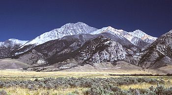
Borah Peak
Borah Peak is the highest mountain in the U.S. state of Idaho. It is located in the central section of the Lost River Range, within the Challis National Forest in eastern Custer County. The peak is named for William Borah , a prominent U.S...
, the highest, climbs to 12,662 feet (3859 m). Further south are Mount Idaho (12,065 ft, 3677 m), Leatherman Peak (12,228 ft, 3727 m), Mount Church (over 12,200 ft, 3720 m), Mount Breitenbach (12,140 ft, 3700 m), and Lost River Mountain (12,078 ft, 3681 m). To the east of this section of the range lie the remote canyons of the Upper Pashimeroi Valley, including scenic Merriam Lake
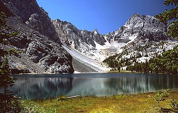
Merriam Lake
Merriam Lake is situated in the Lost River Range in Idaho, surrounded by mountains over high....
.
The range then descends to Pass Creek Summit, the second road to cross its crest. It continues to King Mountain (10,612 ft, 3235 m), a favorite site for hang gliders. Finally it descends sharply to the Snake River Valley near the community of Arco, at an elevation of 5300 feet (1615 m).
External links
- "Lost River Range". SummitPost.org.