

Butte County, Idaho
Encyclopedia
Butte County is a rural county
located in the U.S. state
of Idaho
. It was established in 1917, and its county seat
and largest city is Arco
. As of the 2010 census, the county had a population of 2,891. Much of the eastern part of the county is the vast Idaho National Laboratory
, which extends eastward into neighboring counties.
The Little Lost River
is located in Butte County. Its waters, along with the Big Lost River
, disappear from the surface to flow underground into the Snake River Plain
aquifer in Butte County.
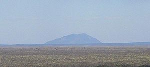
The county was named for the volcanic buttes that rise from the desert plain; the largest is Big Southern Butte
, located in the southern part of the county. It rises 2500 feet (762 m) above the desert floor and was used as a landmark by pioneers.
The southwestern portion of the county includes the visitor center at the Craters of the Moon National Monument and Preserve
, which extends south & west into three other counties.
of 2000, there were 2,899 people, 1,089 households, and 802 families residing in the county. The population density
was 1 people per square mile (0/km²). There were 1,290 housing units at an average density of 1 per square mile (0/km²). The racial makeup of the county was 94.65% White
, 0.28% Black
or African American
, 0.69% Native American
, 0.24% Asian
, 2.38% from other races
, and 1.76% from two or more races. 4.14% of the population were Hispanic
or Latino
of any race. 25.3% were of English
, 13.4% American
, 8.5% German
, 6.3% Irish
and 5.5% Swedish ancestry according to Census 2000.
There were 1,089 households out of which 32.80% had children under the age of 18 living with them, 63.20% were married couples
living together, 7.40% had a female householder with no husband present, and 26.30% were non-families. 23.60% of all households were made up of individuals and 10.90% had someone living alone who was 65 years of age or older. The average household size was 2.64 and the average family size was 3.14.
In the county the population was spread out with 29.00% under the age of 18, 6.30% from 18 to 24, 24.00% from 25 to 44, 25.70% from 45 to 64, and 14.90% who were 65 years of age or older. The median age was 39 years. For every 100 females there were 101.20 males. For every 100 females age 18 and over, there were 99.30 males.
The median income for a household in the county was $30,473, and the median income for a family was $36,950. Males had a median income of $37,750 versus $20,962 for females. The per capita income
for the county was $14,948. About 14.70% of families and 18.20% of the population were below the poverty line, including 27.70% of those under age 18 and 8.10% of those age 65 or over.
County (United States)
In the United States, a county is a geographic subdivision of a state , usually assigned some governmental authority. The term "county" is used in 48 of the 50 states; Louisiana is divided into parishes and Alaska into boroughs. Parishes and boroughs are called "county-equivalents" by the U.S...
located in the U.S. state
U.S. state
A U.S. state is any one of the 50 federated states of the United States of America that share sovereignty with the federal government. Because of this shared sovereignty, an American is a citizen both of the federal entity and of his or her state of domicile. Four states use the official title of...
of Idaho
Idaho
Idaho is a state in the Rocky Mountain area of the United States. The state's largest city and capital is Boise. Residents are called "Idahoans". Idaho was admitted to the Union on July 3, 1890, as the 43rd state....
. It was established in 1917, and its county seat
County seat
A county seat is an administrative center, or seat of government, for a county or civil parish. The term is primarily used in the United States....
and largest city is Arco
Arco, Idaho
Arco is a city in Butte County, Idaho, United States. The population was 995 at the 2010 census. The city is the county seat of Butte County.Craters of the Moon National Monument is located along U.S. Route 20, southwest of the city. The Idaho National Laboratory is located east of Arco...
. As of the 2010 census, the county had a population of 2,891. Much of the eastern part of the county is the vast Idaho National Laboratory
Idaho National Laboratory
Idaho National Laboratory is an complex located in the high desert of eastern Idaho, between the town of Arco to the west and the cities of Idaho Falls and Blackfoot to the east. It lies within Butte, Bingham, Bonneville and Jefferson counties...
, which extends eastward into neighboring counties.
Geography
According to the 2000 census, the county has a total area of 2233.59 square miles (5,785 km²), of which 2232.85 square miles (5,783.1 km²) (or 99.97%) is land and 0.74 square miles (1.9 km²) (or 0.03%) is water.The Little Lost River
Little Lost River
The Little Lost River is a river in the central part of the U.S. state of Idaho. The river is about long and drains an arid farming valley, the Little Lost River Valley, bordered by the Lost River Range on the west and Lemhi Range on the east...
is located in Butte County. Its waters, along with the Big Lost River
Big Lost River
The Big Lost River is a major river in the U.S. state of Idaho, about long. It starts in the Rocky Mountains and flows in a generally southeast direction into the Snake River Plain. True to its name, the Big Lost River's surface flow does not reach any larger river, but vanishes into the Snake...
, disappear from the surface to flow underground into the Snake River Plain
Snake River Plain
The Snake River Plain is a geologic feature located primarily within the state of Idaho in the United States of America. It stretches about westward from northwest of the state of Wyoming to the Idaho-Oregon border. The plain is a wide flat bow-shaped depression, and covers about a quarter of Idaho...
aquifer in Butte County.
The county was named for the volcanic buttes that rise from the desert plain; the largest is Big Southern Butte
Big Southern Butte
Big Southern Butte is the largest and youngest of three rhyolitic domes formed over a million years near the center of the Eastern Snake River Plain in the U.S. state of Idaho. In fact, it is one of the largest volcanic domes on earth...
, located in the southern part of the county. It rises 2500 feet (762 m) above the desert floor and was used as a landmark by pioneers.
The southwestern portion of the county includes the visitor center at the Craters of the Moon National Monument and Preserve
Craters of the Moon National Monument and Preserve
Craters of the Moon National Monument and Preserve is a national monument and national preserve located in the Snake River Plain in central Idaho, U.S.A. It is along US 20 , between the small cities of Arco and Carey, at an average elevation of above sea level...
, which extends south & west into three other counties.
Adjacent counties
- Clark CountyClark County, IdahoClark County is a rural county located in the U.S. state of Idaho. As of the 2000 Census the county had a population of 1,022 . The county seat and largest city is Dubois...
- northeast - Jefferson CountyJefferson County, IdahoJefferson County is a county located in the U.S. state of Idaho. The county was established in 1913, and was named after Thomas Jefferson, the third U.S. President. As of the 2000 Census the county had a population of 19,155 . The county seat and largest city is Rigby...
- east - Bingham CountyBingham County, IdahoBingham County is a county located in the U.S. state of Idaho. As of the 2000 Census the county had a population of 41,735 . The county seat and largest city is Blackfoot. Bingham County comprises the Blackfoot, ID, Micropolitan Statistical Area.Bingham County was created January 13, 1885, and...
- southeast - Blaine CountyBlaine County, IdahoBlaine County is a county located in the U.S. state of Idaho. As of the 2010 Census the county had a population of 21,376. The county seat and largest city is Hailey. The county is home to the Sun Valley ski resort....
- southwest - Lemhi CountyLemhi County, IdahoLemhi County is a county located in the U.S. state of Idaho. The county was established in 1869, named after Fort Lemhi , a remote Mormon missionary settlement from 1855-58 in Bannock and Shoshone territory. As of the 2000 Census the county had a population of 7,806...
- northwest - Custer CountyCuster County, IdahoCuster County is a rural mountain county located in the center of the U.S. state of Idaho. Established in 1881, it was named for the General Custer Mine, where gold was discovered five years earlier . The population was 4,342 at the 2000 census; it is estimated to have fallen to 4,166 by 2007...
- northwest
National protected areas
- Caribou-Targhee National ForestCaribou-Targhee National ForestCaribou-Targhee National Forest is located in the states of Idaho and Wyoming, with a small section in Utah in the United States. The forest is broken into several separate sections and extends over . To the east the forest borders Yellowstone National Park, Grand Teton National Park and...
(part) - Craters of the Moon National Monument and PreserveCraters of the Moon National Monument and PreserveCraters of the Moon National Monument and Preserve is a national monument and national preserve located in the Snake River Plain in central Idaho, U.S.A. It is along US 20 , between the small cities of Arco and Carey, at an average elevation of above sea level...
(part) - Salmon-Challis National ForestSalmon-Challis National ForestSalmon-Challis National Forest is located in east central sections of the U.S. state of Idaho. At 4,235,940 acres it is one of the largest national forests in the lower 48 states and also has most of the land area of the Frank Church River of No Return Wilderness, which is the largest wilderness...
(part)
Highways
 - US 20
 - US 26
 - US 93U.S. Route 93 in IdahoU.S. Route 93 is a north–south U.S. Highway in the U.S. state of Idaho.-Route description:US 93 enters Idaho from a point immediately north of the border casino town of Jackpot, Nevada....
 - SH-22
 - SH-33
Demographics
As of the censusCensus
A census is the procedure of systematically acquiring and recording information about the members of a given population. It is a regularly occurring and official count of a particular population. The term is used mostly in connection with national population and housing censuses; other common...
of 2000, there were 2,899 people, 1,089 households, and 802 families residing in the county. The population density
Population density
Population density is a measurement of population per unit area or unit volume. It is frequently applied to living organisms, and particularly to humans...
was 1 people per square mile (0/km²). There were 1,290 housing units at an average density of 1 per square mile (0/km²). The racial makeup of the county was 94.65% White
Race (United States Census)
Race and ethnicity in the United States Census, as defined by the Federal Office of Management and Budget and the United States Census Bureau, are self-identification data items in which residents choose the race or races with which they most closely identify, and indicate whether or not they are...
, 0.28% Black
Race (United States Census)
Race and ethnicity in the United States Census, as defined by the Federal Office of Management and Budget and the United States Census Bureau, are self-identification data items in which residents choose the race or races with which they most closely identify, and indicate whether or not they are...
or African American
Race (United States Census)
Race and ethnicity in the United States Census, as defined by the Federal Office of Management and Budget and the United States Census Bureau, are self-identification data items in which residents choose the race or races with which they most closely identify, and indicate whether or not they are...
, 0.69% Native American
Race (United States Census)
Race and ethnicity in the United States Census, as defined by the Federal Office of Management and Budget and the United States Census Bureau, are self-identification data items in which residents choose the race or races with which they most closely identify, and indicate whether or not they are...
, 0.24% Asian
Race (United States Census)
Race and ethnicity in the United States Census, as defined by the Federal Office of Management and Budget and the United States Census Bureau, are self-identification data items in which residents choose the race or races with which they most closely identify, and indicate whether or not they are...
, 2.38% from other races
Race (United States Census)
Race and ethnicity in the United States Census, as defined by the Federal Office of Management and Budget and the United States Census Bureau, are self-identification data items in which residents choose the race or races with which they most closely identify, and indicate whether or not they are...
, and 1.76% from two or more races. 4.14% of the population were Hispanic
Race (United States Census)
Race and ethnicity in the United States Census, as defined by the Federal Office of Management and Budget and the United States Census Bureau, are self-identification data items in which residents choose the race or races with which they most closely identify, and indicate whether or not they are...
or Latino
Race (United States Census)
Race and ethnicity in the United States Census, as defined by the Federal Office of Management and Budget and the United States Census Bureau, are self-identification data items in which residents choose the race or races with which they most closely identify, and indicate whether or not they are...
of any race. 25.3% were of English
English people
The English are a nation and ethnic group native to England, who speak English. The English identity is of early mediaeval origin, when they were known in Old English as the Anglecynn. England is now a country of the United Kingdom, and the majority of English people in England are British Citizens...
, 13.4% American
United States
The United States of America is a federal constitutional republic comprising fifty states and a federal district...
, 8.5% German
Germans
The Germans are a Germanic ethnic group native to Central Europe. The English term Germans has referred to the German-speaking population of the Holy Roman Empire since the Late Middle Ages....
, 6.3% Irish
Irish people
The Irish people are an ethnic group who originate in Ireland, an island in northwestern Europe. Ireland has been populated for around 9,000 years , with the Irish people's earliest ancestors recorded having legends of being descended from groups such as the Nemedians, Fomorians, Fir Bolg, Tuatha...
and 5.5% Swedish ancestry according to Census 2000.
There were 1,089 households out of which 32.80% had children under the age of 18 living with them, 63.20% were married couples
Marriage
Marriage is a social union or legal contract between people that creates kinship. It is an institution in which interpersonal relationships, usually intimate and sexual, are acknowledged in a variety of ways, depending on the culture or subculture in which it is found...
living together, 7.40% had a female householder with no husband present, and 26.30% were non-families. 23.60% of all households were made up of individuals and 10.90% had someone living alone who was 65 years of age or older. The average household size was 2.64 and the average family size was 3.14.
In the county the population was spread out with 29.00% under the age of 18, 6.30% from 18 to 24, 24.00% from 25 to 44, 25.70% from 45 to 64, and 14.90% who were 65 years of age or older. The median age was 39 years. For every 100 females there were 101.20 males. For every 100 females age 18 and over, there were 99.30 males.
The median income for a household in the county was $30,473, and the median income for a family was $36,950. Males had a median income of $37,750 versus $20,962 for females. The per capita income
Per capita income
Per capita income or income per person is a measure of mean income within an economic aggregate, such as a country or city. It is calculated by taking a measure of all sources of income in the aggregate and dividing it by the total population...
for the county was $14,948. About 14.70% of families and 18.20% of the population were below the poverty line, including 27.70% of those under age 18 and 8.10% of those age 65 or over.
Cities and towns
- ArcoArco, IdahoArco is a city in Butte County, Idaho, United States. The population was 995 at the 2010 census. The city is the county seat of Butte County.Craters of the Moon National Monument is located along U.S. Route 20, southwest of the city. The Idaho National Laboratory is located east of Arco...
- Butte CityButte City, IdahoButte City is a city in Butte County, Idaho, United States. The population was 76 at the 2000 census.-Geography:Butte City is located at ....
- Darlington
- Howe
- MooreMoore, IdahoMoore is a city in Butte County, Idaho, United States. The population was 196 at the 2000 census.-Geography:Moore is located at .According to the United States Census Bureau, the city has a total area of , all of it land....