
Arctic Cordillera
Encyclopedia
The Arctic Cordillera
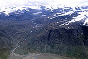
is a vast, deeply dissected chain of mountain range
s extending along the northeastern flank of the Canadian Arctic Archipelago
from Ellesmere Island
to the northeasternmost part of the Labrador Peninsula
in northern Labrador
and northern Quebec
, Canada
. It spans most of the eastern coast of Nunavut
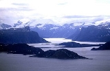
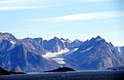
with high glaciated peaks rising through icefields and some of Canada's largest ice caps, including the Penny Ice Cap
on Baffin Island
. It is bounded to the east by Baffin Bay
, Davis Strait
and the Labrador Sea
while its northern portion is bounded by the Arctic Ocean
.
on Ellesmere Island at 2616 m (8,583 ft), which is the highest point in eastern North America
. The system is also one of Canada's three mountain systems, the others being the Western Cordillera of Western Canada
and the Canadian extension of the Appalachian Mountains
into the Gaspe Peninsula
and Atlantic Provinces.
The Arctic Cordillera is a narrow ecozone
compared to other Canadian ecozones. The majority of this ecozone borders the Northern Arctic
, while the small segment within Labrador borders the Taiga Shield
. However, bordering the Taiga Shield seems to affect neither itself nor the ecozones it borders because their biological properties appear to be opposites (cold climate versus warm climate; different species of plants and animals). While the Arctic Cordillera mountain system includes most of the Arctic islands and regions such as Bathurst Island
, Cornwall Island, Amund Ringnes Island
, Ellef Ringnes Island
, Ellesmere Island, Baffin Island, Bylot Island
and Labrador, the Arctic Cordillera Ecozone only covers Ellesmere Island, Baffin Island, Axel Heiberg Island
, Bylot Island and Labrador.
, with Cape Columbia
being the most northerly point of land in Canada. It encompasses an area of 196235 km² (75,767 sq mi), making it the world's tenth largest island and Canada's third largest island. The first inhabitants of Ellesmere Island were small bands of Inuit
drawn to the area for Peary Caribou
, muskox, and marine mammal
hunting about 1000-2000 BC.
Axel Heiberg Island is one of the several members of the Canadian Arctic Archipelago and the largest of the Sverdrup Islands
. It has been inhabited in the past by Inuit people, but was uninhabited by the time it was named by Otto Sverdrup
, who explored it around 1900. In 1959, scientists from McGill University
explored Expedition Fiord in central Axel Heiberg Island. This resulted in the establishment of the McGill Arctic Research Station, constructed 8 km (5 mi) inland from Expedition Fjord in 1960.
Baffin Island is the largest island in Canada and the fifth largest island in the world, with an area of 507451 km² (195,928 sq mi).
The largest uninhabited island on Earth
, Devon Island
is the second-largest of the Queen Elizabeth Islands, the 27th largest island in the world and Canada's 6th largest island. An outpost was established at Dundas Harbour
in August 1924 as part of a government presence intended to curb foreign whaling
and other activity.
Much of Bylot Island is covered by the Arctic Cordillera. At 11067 km² (4,273 sq mi) it is ranked 71st largest island in the world and Canada's 17th largest island. While there are no permanent settlements on this Canadian Arctic island, Inuit from Pond Inlet and elsewhere regularly travel to Bylot Island.
 More than one-fifth of Ellesmere Island is protected as Quttinirpaaq National Park
(formerly Ellesmere Island National Park), which includes seven fjord
s and a variety of glacier
s, as well as Lake Hazen
, the world's largest lake north of the Arctic Circle
. Barbeau Peak, the highest mountain in Nunavut (2616 m (8,583 ft)) is located in the British Empire Range
on Ellesmere Island. The most northern mountain range in the world, the Challenger Mountains
is located in the northwest region of the island. The northern lobe of the island is called Grant Land
. In July 2007, a study noted the disappearance of habitat
for waterfowl, invertebrates, and algae on Ellesmere Island. According to John P. Smol of Queens University in Kingston, Ontario
, and Marianne S. V. Douglas of the University of Alberta
in Edmonton, warming conditions and evaporation have caused low water levels changes in the chemistry of ponds and wetlands in the area. The researchers noted that "In the 1980s they often needed to wear hip waders to make their way to the ponds...while by 2006 the same areas were dry enough to burn.
Sirmilik National Park
in northern Baffin Island harbours large populations of thick-billed murres, Black-legged Kittiwake
s and greater snow geese
. The park comprises three areas, Bylot Island, Oliver Sound
and the Borden Peninsula
.
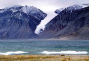
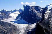
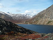
The Auyuittuq National Park
located on Baffin Island's Cumberland Peninsula
, features the many terrains of Arctic
wilderness, such as fjords, glaciers, and ice field
s. In Inuktitut
- the language of Nunavut's Aboriginal people, Inuit - Auyuittuq means "the land that never melts". Although Auyuittuq was established in 1976 as a national park reserve, it was upgraded to a full national park in 2000. Well known peaks in the park include Mount Asgard
and Mount Thor
with a 1250 m (4,101 ft), 105° face.
The Torngat Mountains National Park Reserve
located on the Labrador Peninsula
, covers much of the southern end of the Arctic Cordillera. It protects many of the Arctic wilderness, such as caribou, polar bear
s, peregrine falcon
and the golden eagle
. The park was first established on January 22, 2005, making it the first national park to be created in Labrador.
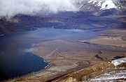
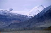
 The drier northern section of the Arctic Cordillera is largely covered with ice cap
s while glaciers are more common at the more humid southern end. Large portions of Ellesmere Island are covered with glaciers and ice, with Manson Icefield and Sydkap in the south; Prince of Wales Icefield and Agassiz Ice Cap along the central-east side of the island, along with substantial ice cover in Northern Ellesmere Island. The northwest coast of Ellesmere Island was covered by a massive, 500 km (310.7 mi) long ice shelf until the 20th century. The Ellesmere ice shelf reduced by 90 percent in the twentieth century due to global warming
, leaving the separate Alfred Ernest, Ayles, Milne, Ward Hunt, and Markham Ice Shelves. A 1986 survey of Canadian ice shelves found that 48 km² (19 sq mi) 3.3 km³ (0.791712103394146 cu mi) of ice calved from the Milne
and Ayles
ice shelves between 1959 and 1974. The Ward Hunt Ice Shelf
, the largest remaining section of thick (greater than 10 m (32.8 ft)) landfast sea ice along the northern coastline of Ellesmere Island, lost 600 km (372.8 mi) of ice in a massive calving in 1961-1962. It further decreased by 27% in thickness (13 m, 43 ft) between 1967 and 1999. The breakup of the Ellesmere ice shelves has continued in the 21st century: the Ward Ice Shelf experienced a major breakup during summer 2002; the Ayles Ice Shelf calved entirely on August 13, 2005; the largest breakoff of the ice shelf in 25 years, it may pose a threat to the oil industry in the Beaufort Sea
. The piece is 66 km² (25 sq mi).
The Barnes icecap is found in the central part of the Baffin Island and it has been in retreat since at least the early 1960s when the Geographical Branch of the then Department of Mines & Technical Surveys sent a three-man survey team to the area to measure isostatic rebound and cross-valley features of the Isortoq River.
 The northern portion of the Arctic Cordillera was uplifted during the Innuitian orogeny
when the North American Plate
moved northward during the mid Mesozoic
. It contains igneous and metamorphic rocks, but for the most part is composed of sedimentary rock
s. Mountains on Axel Heiberg Island consist mainly of long ridge
s of folded mid Mesozoic and Palaeozoic strata
with minor igneous intrusion
s.
The Arctic Cordillera is younger than the Appalachians, and so erosion has not had time to reduce it to rounded hill
s. The mountains are also barren because trees can neither survive the extremely cold winter temperatures, nor grow during the short summers. Vast areas are covered by permanent ice and snow. The Arctic Cordillera resembles the Appalachians in composition and contain similar types of mineral
s. The mineral resources have not been greatly exploited, however, because the region's remote location makes development too costly when cheaper alternatives exist further south.
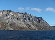
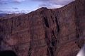
Mountains on southeastern Ellesmere Island are principally made of granitic
gneiss
, migmatic, undifferentiated intrusive and volcanic rocks. They are typified by being highly eroded
, with conspicuous deep vertical fissures and narrow ledges.
The Arctic Cordillera form the eastern edge of the Canadian Shield
, which covers much of Canada's landscape. Precambrian
rock is the major component of the bedrock
.
range in age from 1.2 billion to 65 million years old. The Late Cretaceous
Ellesmere Island Volcanics
has been uncertainly associated to both the early volcanic activity of the Iceland hotspot
and the Alpha Ridge
. Even though these volcanics are about 90 million years old, the volcanoes and cinder
are still able to be seen.
 The Late Cretaceous Strand Fiord Formation
is interpreted to represent the cratonward extension of the Alpha Ridge, a volcanic ridge that was active during the formation of the Amerasian Basin
. The formation is part of the thick Sverdrup Basin succession and immediately precedes the final basin foundering event. The Strand Fiord volcanics are encased in marine strata and thin southward from a maximum thickness of more than 789 m (2,588.6 ft) on northwestern Axel Heiberg to a zero edge near the southern shore of the island. Tholeiitic icelandite
basalt
flows are the main constituent of the formation with pyroclastic conglomerates, sandstone
s, mudrock
s and rare coal seams are also present. The lava flows range in thickness from 6 metre and subaerial flows predominate. Both pahoehoe and aa lava
types are common and the volcanic pile accumulated mostly by the quiet effusion
of lavas. The pyroclastic
lithologies
become more common near the southern and eastern edges of the formation and represent lahar
s and beach to shallow marine reworked deposits. The formation contains flood basalt
s which are found on western Axel Heiberg Island at Dragon Cliffs
300 m (984.3 ft) tall. It contains columnar jointing units that are usually 1 metre in diameter.
The Bravo Lake Formation
in central Baffin Island is a rare alkaline-suite that formed as a result of submarine rift
ing during the Paleoproterozoic
period. The lavas of the volcanic belt
display geochemical characteristics similar to modern ocean-island-basalt groups. The range from moderately to intensely fractionated REE-profiles is similar to that from tholeiitic basalts to extremely alkaline lavas in Hawaii
.
.jpg)
 Not much can grow in the severe environment, where killing frost can come at any time during the year and even soil
is rare. Three-quarters of the land is bare rock
; and even lichen
have a hard time of it. Trees are hardly noticeable. Plants that do grow in the region are mostly tiny species that often grow in thick isolating mats to protect themselves from the cold or are covered in thick hairs that help to insulate and to protect them from the harsh wind.
Some of the plant species found are arctic black spruce
, arctic willow
, cottongrass, crustose
lichens, kobresia
, moss
species, wood rush
, wire rush, purple saxifrage
, Dryas
species, sedge
s, Diapensia
, arctic poppy
, mountain avens, mountain sorrel, river beauty, moss campion
, bilberry
, and arctic white heather.
The conditions here are far too severe for reptile
s and amphibian
s to survive, and insect
s are also rare in the region. Muskoxen and barren-ground caribou are the only large herbivores in this environment, while polar bear
s and the arctic wolf
are the only large carnivores to be found in the region. Smaller herbivores include the arctic hare
and the collared lemming
. Arctic fox
es and stoat
s are some of the smaller carnivores found in the region. Marine mammals include narwhals, beluga whales, walrus
, and ringed
and bearded seal
s.
The furry-legged Rock Ptarmigan is a widespread bird in this region. Typical birds of prey include the Gyrfalcon
and Snowy Owl
. Some of the more widespread shore and seabirds are the Thick-billed Murre, Black-legged kittiwake
, Ruddy Turnstone
, Red Knot
, Black Guillemot
, widespread Ringed Plover
, Little Ringed Plover
and Northern Fulmar
. Songbird
s found in the Arctic Cordillera include the Hoary Redpoll, Common Redpoll
, Snow Bunting
, and Lapland Longspur. The Snow Goose
, Common
and King Eider
, and Red-throated Loon are some species of waterfowl
that live in the region.
 The Arctic Cordillera has one of Canada's most inhospitable climates. During winter, the temperature averages at -35 C, and is very dark and long, while it is somewhat milder and more humid in the southernmost portions of the cordillera
. Only about 2,600 people live in the region, found primarily in the communities of Clyde River
, Qikiqtarjuaq
(formerly known as Broughton Island), and Pond Inlet
. Most of the people who live in the region survive by hunting
, fishing
, and trapping.
Tree stump
s were discovered in 1985 on Axel Heiberg Island dating back 40 million years, indicating this northerly part of the cordillera was warmer and wetter than its present-day climate.
With climate change
, the biodiversity of this ecozone would likely increase. As the average temperature rises, more species would be able to inhabit this formerly cold and barren location. Since the currently limited biodiversity of the Arctic Cordillera is largely due to its cold climate and conditions, the effect of climate change will likely cause the biodiversity to increase dramatically as well. Also, the melting of ice and glaciers will make room for more species of plantae to thrive, as well as cause the appearance of fungi species.
Cordillera
A cordillera is an extensive chain of mountains or mountain ranges, that runs along a coastline . It comes from the Spanish word cordilla, which is a diminutive of cuerda, or "cord"...
is a vast, deeply dissected chain of mountain range
Mountain range
A mountain range is a single, large mass consisting of a succession of mountains or narrowly spaced mountain ridges, with or without peaks, closely related in position, direction, formation, and age; a component part of a mountain system or of a mountain chain...
s extending along the northeastern flank of the Canadian Arctic Archipelago
Canadian Arctic Archipelago
The Canadian Arctic Archipelago, also known as the Arctic Archipelago, is a Canadian archipelago north of the Canadian mainland in the Arctic...
from Ellesmere Island
Ellesmere Island
Ellesmere Island is part of the Qikiqtaaluk Region of the Canadian territory of Nunavut. Lying within the Canadian Arctic Archipelago, it is considered part of the Queen Elizabeth Islands, with Cape Columbia being the most northerly point of land in Canada...
to the northeasternmost part of the Labrador Peninsula
Labrador Peninsula
The Labrador Peninsula is a large peninsula in eastern Canada. It is bounded by the Hudson Bay to the west, the Hudson Strait to the north, the Labrador Sea to the east, and the Gulf of Saint Lawrence to the south-east...
in northern Labrador
Labrador
Labrador is the distinct, northerly region of the Canadian province of Newfoundland and Labrador. It comprises the mainland portion of the province, separated from the island of Newfoundland by the Strait of Belle Isle...
and northern Quebec
Quebec
Quebec or is a province in east-central Canada. It is the only Canadian province with a predominantly French-speaking population and the only one whose sole official language is French at the provincial level....
, Canada
Canada
Canada is a North American country consisting of ten provinces and three territories. Located in the northern part of the continent, it extends from the Atlantic Ocean in the east to the Pacific Ocean in the west, and northward into the Arctic Ocean...
. It spans most of the eastern coast of Nunavut
Nunavut
Nunavut is the largest and newest federal territory of Canada; it was separated officially from the Northwest Territories on April 1, 1999, via the Nunavut Act and the Nunavut Land Claims Agreement Act, though the actual boundaries had been established in 1993...
with high glaciated peaks rising through icefields and some of Canada's largest ice caps, including the Penny Ice Cap
Penny Ice Cap
The Penny Ice Cap is a vast, ice cap in Auyuittuq National Park of Baffin Island, Nunavut, Canada. It forms a high barrier on the Cumberland Peninsula, an area of deep fiords and glaciated valleys. It is a remnant of the last ice age. During the mid 1990s, Canadian researchers studied the...
on Baffin Island
Baffin Island
Baffin Island in the Canadian territory of Nunavut is the largest island in the Canadian Arctic Archipelago, the largest island in Canada and the fifth largest island in the world. Its area is and its population is about 11,000...
. It is bounded to the east by Baffin Bay
Baffin Bay
Baffin Bay , located between Baffin Island and the southwest coast of Greenland, is a marginal sea of the North Atlantic Ocean. It is connected to the Atlantic via Davis Strait and the Labrador Sea...
, Davis Strait
Davis Strait
Davis Strait is a northern arm of the Labrador Sea. It lies between mid-western Greenland and Nunavut, Canada's Baffin Island. The strait was named for the English explorer John Davis , who explored the area while seeking a Northwest Passage....
and the Labrador Sea
Labrador Sea
The Labrador Sea is an arm of the North Atlantic Ocean between the Labrador Peninsula and Greenland. The sea is flanked by continental shelves to the southwest, northwest, and northeast. It connects to the north with Baffin Bay through the Davis Strait...
while its northern portion is bounded by the Arctic Ocean
Arctic Ocean
The Arctic Ocean, located in the Northern Hemisphere and mostly in the Arctic north polar region, is the smallest and shallowest of the world's five major oceanic divisions...
.
Overview
The range is mostly located in Nunavut but extends southeast into the northernmost tip of Labrador and northeastern Quebec. The system is divided into a series of ranges, with mountains reaching heights more than 2000 m (6,562 ft). The highest of the group is Barbeau PeakBarbeau Peak
Barbeau Peak is a mountain in Qikiqtaaluk, Nunavut, Canada. Located on Ellesmere Island within Quttinirpaaq National Park, it is the highest mountain in Nunavut, and the highest in eastern North America . The mountain was named in 1969 for Dr...
on Ellesmere Island at 2616 m (8,583 ft), which is the highest point in eastern North America
North America
North America is a continent wholly within the Northern Hemisphere and almost wholly within the Western Hemisphere. It is also considered a northern subcontinent of the Americas...
. The system is also one of Canada's three mountain systems, the others being the Western Cordillera of Western Canada
Western Canada
Western Canada, also referred to as the Western provinces and commonly as the West, is a region of Canada that includes the four provinces west of the province of Ontario.- Provinces :...
and the Canadian extension of the Appalachian Mountains
Appalachian Mountains
The Appalachian Mountains #Whether the stressed vowel is or ,#Whether the "ch" is pronounced as a fricative or an affricate , and#Whether the final vowel is the monophthong or the diphthong .), often called the Appalachians, are a system of mountains in eastern North America. The Appalachians...
into the Gaspe Peninsula
Gaspé Peninsula
The Gaspésie , or Gaspé Peninsula or the Gaspé, is a peninsula along the south shore of the Saint Lawrence River in Quebec, Canada, extending into the Gulf of Saint Lawrence...
and Atlantic Provinces.
The Arctic Cordillera is a narrow ecozone
Ecozones of Canada
The ecozones of Canada consist of fifteen terrestrial and five marine ecozones in Canada. These are further subdivided into 53 ecoprovinces, 194 ecoregions, and 1021 ecodistricts...
compared to other Canadian ecozones. The majority of this ecozone borders the Northern Arctic
Northern Arctic
The Northern Arctic Ecozone is a Canadian terrestrial ecozone which includes most of the Canadian Arctic Archipelago, the northeast peninsula of Nunavut, and the northwestern tip of Quebec...
, while the small segment within Labrador borders the Taiga Shield
Taiga Shield
The Taiga Shield Ecozone is an ecozone which stretches across Canada's subarctic region. Some regions exhibit exposed Precambrian bedrock of the Canadian Shield, the oldest of the world's geological formations...
. However, bordering the Taiga Shield seems to affect neither itself nor the ecozones it borders because their biological properties appear to be opposites (cold climate versus warm climate; different species of plants and animals). While the Arctic Cordillera mountain system includes most of the Arctic islands and regions such as Bathurst Island
Bathurst Island
A member of the Canadian Arctic Archipelago, Bathurst Island is one of the Queen Elizabeth Islands in Nunavut Territory, Canada. The area of the island is estimated at , making it the 54th largest island in the world and Canada's 13th largest island. It is uninhabited.The island is low-lying with...
, Cornwall Island, Amund Ringnes Island
Amund Ringnes Island
Amund Ringnes Island is one of the Sverdrup Islands in the Qikiqtaaluk Region, Nunavut, Canada. It is located in the Arctic Ocean, between 78 and 79 degrees of latitude. It lies east of Ellef Ringnes Island, west of Axel Heiberg Island. Hassel Sound separates Amund Ringnes Island from Ellef Ringnes...
, Ellef Ringnes Island
Ellef Ringnes Island
Ellef Ringnes Island is one of the Sverdrup Islands in Qikiqtaaluk Region, Nunavut, Canada. Also a member of the Queen Elizabeth Islands and Canadian Arctic Archipelago, it is located in the Arctic Ocean, east of Borden Island, and west of Amund Ringnes Island...
, Ellesmere Island, Baffin Island, Bylot Island
Bylot Island
Bylot Island lies off the northern end of Baffin Island in Nunavut Territory, Canada. At it is ranked 71st largest island in the world and Canada's 17th largest island. It is also one of the largest uninhabited islands in the world. While there are no permanent settlements on this Canadian Arctic...
and Labrador, the Arctic Cordillera Ecozone only covers Ellesmere Island, Baffin Island, Axel Heiberg Island
Axel Heiberg Island
Axel Heiberg Island is an island in the Qikiqtaaluk Region, Nunavut, Canada. Located in the Arctic Ocean, it is the 31st largest island in the world and Canada's seventh largest island. According to Statistics Canada, it has an area of ....
, Bylot Island and Labrador.
Regions
The Arctic Cordillera contains numerous regions. Much of Ellesmere Island is covered by the Arctic Cordillera, making it the most mountainous in the Canadian Arctic Archipelago. It is considered part of the Queen Elizabeth IslandsQueen Elizabeth Islands
The Queen Elizabeth Islands are the northernmost cluster of islands in the Canadian Arctic Archipelago, split between Nunavut and Northwest Territories in Northern Canada.-Geography:...
, with Cape Columbia
Cape Columbia
Cape Columbia is the northernmost point of land of Canada, located on Ellesmere Island in the Qikiqtaaluk Region of Nunavut. It marks the westernmost coastal point of Lincoln Sea in the Arctic Ocean...
being the most northerly point of land in Canada. It encompasses an area of 196235 km² (75,767 sq mi), making it the world's tenth largest island and Canada's third largest island. The first inhabitants of Ellesmere Island were small bands of Inuit
Inuit
The Inuit are a group of culturally similar indigenous peoples inhabiting the Arctic regions of Canada , Denmark , Russia and the United States . Inuit means “the people” in the Inuktitut language...
drawn to the area for Peary Caribou
Peary Caribou
The Peary Caribou is a caribou subspecies found in the high Arctic islands of Canada's Nunavut and Northwest territories. They are the smallest of the North American caribou, with the females weighing an average of 60 kg and the males 110 kg...
, muskox, and marine mammal
Marine mammal
Marine mammals, which include seals, whales, dolphins, and walruses, form a diverse group of 128 species that rely on the ocean for their existence. They do not represent a distinct biological grouping, but rather are unified by their reliance on the marine environment for feeding. The level of...
hunting about 1000-2000 BC.
Axel Heiberg Island is one of the several members of the Canadian Arctic Archipelago and the largest of the Sverdrup Islands
Sverdrup Islands
The Sverdrup Islands is an archipelago of the northern Queen Elizabeth Islands, in Nunavut, Canada. The islands are situated in the Arctic Ocean, west of Ellesmere Island from 77° to 81° North and 85° to 106° West.- History :...
. It has been inhabited in the past by Inuit people, but was uninhabited by the time it was named by Otto Sverdrup
Otto Sverdrup
Otto Neumann Knoph Sverdrup was a Norwegian sailor and Arctic explorer.-Early and personal life:...
, who explored it around 1900. In 1959, scientists from McGill University
McGill University
Mohammed Fathy is a public research university located in Montreal, Quebec, Canada. The university bears the name of James McGill, a prominent Montreal merchant from Glasgow, Scotland, whose bequest formed the beginning of the university...
explored Expedition Fiord in central Axel Heiberg Island. This resulted in the establishment of the McGill Arctic Research Station, constructed 8 km (5 mi) inland from Expedition Fjord in 1960.
Baffin Island is the largest island in Canada and the fifth largest island in the world, with an area of 507451 km² (195,928 sq mi).
The largest uninhabited island on Earth
Earth
Earth is the third planet from the Sun, and the densest and fifth-largest of the eight planets in the Solar System. It is also the largest of the Solar System's four terrestrial planets...
, Devon Island
Devon Island
Devon Island , claimed to be the largest uninhabited island on Earth, is located in Baffin Bay, Qikiqtaaluk Region, Nunavut, Canada. It is one of the larger members of the Canadian Arctic Archipelago, the second-largest of the Queen Elizabeth Islands, Canada's sixth largest island, and the 27th...
is the second-largest of the Queen Elizabeth Islands, the 27th largest island in the world and Canada's 6th largest island. An outpost was established at Dundas Harbour
Dundas Harbour, Nunavut
Dundas Harbour is an abandoned settlement in Qikiqtaaluk, Nunavut, Canada. It is located on Devon Island at the eastern shore of the waterway also named Dundas Harbour...
in August 1924 as part of a government presence intended to curb foreign whaling
Whaling
Whaling is the hunting of whales mainly for meat and oil. Its earliest forms date to at least 3000 BC. Various coastal communities have long histories of sustenance whaling and harvesting beached whales...
and other activity.
Much of Bylot Island is covered by the Arctic Cordillera. At 11067 km² (4,273 sq mi) it is ranked 71st largest island in the world and Canada's 17th largest island. While there are no permanent settlements on this Canadian Arctic island, Inuit from Pond Inlet and elsewhere regularly travel to Bylot Island.
Protected areas
Quttinirpaaq National Park
-See also:*List of National Parks of Canada*List of protected areas of Nunavut*Arctic Cordillera-External links:**...
(formerly Ellesmere Island National Park), which includes seven fjord
Fjord
Geologically, a fjord is a long, narrow inlet with steep sides or cliffs, created in a valley carved by glacial activity.-Formation:A fjord is formed when a glacier cuts a U-shaped valley by abrasion of the surrounding bedrock. Glacial melting is accompanied by rebound of Earth's crust as the ice...
s and a variety of glacier
Glacier
A glacier is a large persistent body of ice that forms where the accumulation of snow exceeds its ablation over many years, often centuries. At least 0.1 km² in area and 50 m thick, but often much larger, a glacier slowly deforms and flows due to stresses induced by its weight...
s, as well as Lake Hazen
Lake Hazen
Lake Hazen is often called the northernmost lake of Canada, in the northern part of Ellesmere Island, Nunavut, but detailed maps show several smaller lakes up to more than farther north on Canada's northernmost island. Turnabout Lake is immediately northeast of the northern end of Hazen lake...
, the world's largest lake north of the Arctic Circle
Arctic Circle
The Arctic Circle is one of the five major circles of latitude that mark maps of the Earth. For Epoch 2011, it is the parallel of latitude that runs north of the Equator....
. Barbeau Peak, the highest mountain in Nunavut (2616 m (8,583 ft)) is located in the British Empire Range
British Empire Range
The British Empire Range is a mountain range on Ellesmere Island in Nunavut, Canada. The range is one of the most northern ranges in the world and the Arctic Cordillera, surpassed only by the Challenger Mountains which lies immediately to the northwest and the United States Range slightly further...
on Ellesmere Island. The most northern mountain range in the world, the Challenger Mountains
Challenger Mountains
The Challenger Mountains are a mountain range on Ellesmere Island in Nunavut, Canada. The range is the most northern range in the world and of the Arctic Cordillera. The highest mountain in the range is Commonwealth Mountain...
is located in the northwest region of the island. The northern lobe of the island is called Grant Land
Grant Land
Grant Land is the northern lobe of Ellesmere Island, Nunavut, Canada. Situated on the north coast, Cape Columbia, is the northernmost point of Canada, only 770 km from the North Pole, and was used as the final point on land for Peary's North Pole expedition in 1909.At its highest point, it is ...
. In July 2007, a study noted the disappearance of habitat
Habitat
* Habitat , a place where a species lives and grows*Human habitat, a place where humans live, work or play** Space habitat, a space station intended as a permanent settlement...
for waterfowl, invertebrates, and algae on Ellesmere Island. According to John P. Smol of Queens University in Kingston, Ontario
Kingston, Ontario
Kingston, Ontario is a Canadian city located in Eastern Ontario where the St. Lawrence River flows out of Lake Ontario. Originally a First Nations settlement called "Katarowki," , growing European exploration in the 17th Century made it an important trading post...
, and Marianne S. V. Douglas of the University of Alberta
University of Alberta
The University of Alberta is a public research university located in Edmonton, Alberta, Canada. Founded in 1908 by Alexander Cameron Rutherford, the first premier of Alberta and Henry Marshall Tory, its first president, it is widely recognized as one of the best universities in Canada...
in Edmonton, warming conditions and evaporation have caused low water levels changes in the chemistry of ponds and wetlands in the area. The researchers noted that "In the 1980s they often needed to wear hip waders to make their way to the ponds...while by 2006 the same areas were dry enough to burn.
Sirmilik National Park
Sirmilik National Park
Sirmilik National Park is a protected area located in Qikiqtaaluk, Nunavut, Canada. It was established in 2001. Situated within the Arctic Cordillera, it is composed of three areas: most of Bylot Island with the exception for a few areas that are Inuit-owned lands, Oliver Sound, and Baffin...
in northern Baffin Island harbours large populations of thick-billed murres, Black-legged Kittiwake
Black-legged Kittiwake
The Black-legged Kittiwake is a seabird species in the gull family Laridae.This species was first described by Linnaeus in his Systema naturae in 1758 as Larus tridactylus....
s and greater snow geese
Snow Goose
The Snow Goose , also known as the Blue Goose, is a North American species of goose. Its name derives from the typically white plumage. The genus of this bird is disputed...
. The park comprises three areas, Bylot Island, Oliver Sound
Oliver Sound
Oliver Sound is an uninhabited natural waterway within Qikiqtaaluk Region, Nunavut, Canada. It is located at the northern end of Baffin Island, north of Tay Sound. Its mouth opens to Eclipse Sound. Pond Inlet is the nearest community. The sound makes up part of Sirmilik National Park....
and the Borden Peninsula
Borden Peninsula
The Borden Peninsula is a peninsula on northern Baffin Island, in Nunavut, Canada. It lies south of Lancaster Sound. Northeastern Borden Peninsula is home to Sirmilik National Park.-Geography:Borden Peninsula extends north for . It is - wide....
.
The Auyuittuq National Park
Auyuittuq National Park
Auyuittuq National Park is a national park located on Baffin Island's Cumberland Peninsula, Qikiqtaaluk Region in Nunavut, the largest political subdivision of Canada. It features the many terrains of Arctic wilderness, such as fjords, glaciers, and ice fields...
located on Baffin Island's Cumberland Peninsula
Cumberland Peninsula
Cumberland Peninsula is a peninsula in the southeastern part of Baffin Island, in Nunavut, Canada. It is located between 64°56' and 67°57' north latitude, and 61°56' to 68° west longitude. The Arctic Circle crosses the peninsula, with the Labrador Sea to the southeast, and the Davis Strait to the...
, features the many terrains of Arctic
Arctic
The Arctic is a region located at the northern-most part of the Earth. The Arctic consists of the Arctic Ocean and parts of Canada, Russia, Greenland, the United States, Norway, Sweden, Finland, and Iceland. The Arctic region consists of a vast, ice-covered ocean, surrounded by treeless permafrost...
wilderness, such as fjords, glaciers, and ice field
Ice field
An ice field is an area less than 50,000 km² of ice often found in the colder climates and higher altitudes of the world where there is sufficient precipitation. It is an extensive area of interconnected valley glaciers from which the higher peaks rise as nunataks...
s. In Inuktitut
Inuktitut
Inuktitut or Eastern Canadian Inuktitut, Eastern Canadian Inuit language is the name of some of the Inuit languages spoken in Canada...
- the language of Nunavut's Aboriginal people, Inuit - Auyuittuq means "the land that never melts". Although Auyuittuq was established in 1976 as a national park reserve, it was upgraded to a full national park in 2000. Well known peaks in the park include Mount Asgard
Mount Asgard
Mount Asgard is a twin peaked mountain with two flat-topped cylindrical rock towers, separated by a saddle. It is located in Auyuittuq National Park, on the Cumberland Peninsula of Baffin Island, Nunavut, Canada. The peak is named after Asgard, the realm of the gods in Norse mythology...
and Mount Thor
Mount Thor
Mount Thor, officially gazetted as Thor Peak, is a mountain with an elevation of 1,675 m located in Auyuittuq National Park, on Baffin Island, Nunavut, Canada. The mountain is located northeast of Pangnirtung and features the Earth's greatest purely vertical drop at , with an average angle of 105...
with a 1250 m (4,101 ft), 105° face.
The Torngat Mountains National Park Reserve
Torngat Mountains National Park Reserve
Torngat Mountains National Park is a Canadian national park, located on the Labrador Peninsula at the northern tip of Newfoundland and Labrador.The park was established on 22 January 2005, making it the first national park to be created in Labrador...
located on the Labrador Peninsula
Labrador Peninsula
The Labrador Peninsula is a large peninsula in eastern Canada. It is bounded by the Hudson Bay to the west, the Hudson Strait to the north, the Labrador Sea to the east, and the Gulf of Saint Lawrence to the south-east...
, covers much of the southern end of the Arctic Cordillera. It protects many of the Arctic wilderness, such as caribou, polar bear
Polar Bear
The polar bear is a bear native largely within the Arctic Circle encompassing the Arctic Ocean, its surrounding seas and surrounding land masses. It is the world's largest land carnivore and also the largest bear, together with the omnivorous Kodiak Bear, which is approximately the same size...
s, peregrine falcon
Peregrine Falcon
The Peregrine Falcon , also known as the Peregrine, and historically as the Duck Hawk in North America, is a widespread bird of prey in the family Falconidae. A large, crow-sized falcon, it has a blue-gray back, barred white underparts, and a black head and "moustache"...
and the golden eagle
Golden Eagle
The Golden Eagle is one of the best known birds of prey in the Northern Hemisphere. Like all eagles, it belongs to the family Accipitridae. Once widespread across the Holarctic, it has disappeared from many of the more heavily populated areas...
. The park was first established on January 22, 2005, making it the first national park to be created in Labrador.
Glaciers and ice caps
Ice cap
An ice cap is an ice mass that covers less than 50 000 km² of land area . Masses of ice covering more than 50 000 km² are termed an ice sheet....
s while glaciers are more common at the more humid southern end. Large portions of Ellesmere Island are covered with glaciers and ice, with Manson Icefield and Sydkap in the south; Prince of Wales Icefield and Agassiz Ice Cap along the central-east side of the island, along with substantial ice cover in Northern Ellesmere Island. The northwest coast of Ellesmere Island was covered by a massive, 500 km (310.7 mi) long ice shelf until the 20th century. The Ellesmere ice shelf reduced by 90 percent in the twentieth century due to global warming
Global warming
Global warming refers to the rising average temperature of Earth's atmosphere and oceans and its projected continuation. In the last 100 years, Earth's average surface temperature increased by about with about two thirds of the increase occurring over just the last three decades...
, leaving the separate Alfred Ernest, Ayles, Milne, Ward Hunt, and Markham Ice Shelves. A 1986 survey of Canadian ice shelves found that 48 km² (19 sq mi) 3.3 km³ (0.791712103394146 cu mi) of ice calved from the Milne
Milne Ice Shelf
The Milne Ice Shelf, a fragment of the former Ellesmere Ice Shelf, is located in Qikiqtaaluk Region, Nunavut, Canada. It is the second largest ice shelf in the Arctic Ocean...
and Ayles
Ayles Ice Shelf
The Ayles Ice Shelf was one of six major ice shelves in Canada, all located on the northern coast of Ellesmere Island, Nunavut. The ice shelf broke off from the coast on August 13, 2005, forming a giant ice island thick and measuring around by in size . The oldest ice in the ice shelf is...
ice shelves between 1959 and 1974. The Ward Hunt Ice Shelf
Ward Hunt Ice Shelf
The Ward Hunt Ice Shelf is the largest ice shelf in the Arctic, located on the north coast of Ellesmere Island, Nunavut, Canada. During the 20th century the Ellesmere Ice Shelf broke up into six separate shelves, the largest being Ward Hunt...
, the largest remaining section of thick (greater than 10 m (32.8 ft)) landfast sea ice along the northern coastline of Ellesmere Island, lost 600 km (372.8 mi) of ice in a massive calving in 1961-1962. It further decreased by 27% in thickness (13 m, 43 ft) between 1967 and 1999. The breakup of the Ellesmere ice shelves has continued in the 21st century: the Ward Ice Shelf experienced a major breakup during summer 2002; the Ayles Ice Shelf calved entirely on August 13, 2005; the largest breakoff of the ice shelf in 25 years, it may pose a threat to the oil industry in the Beaufort Sea
Beaufort Sea
The Beaufort Sea is a marginal sea of the Arctic Ocean, located north of the Northwest Territories, the Yukon, and Alaska, west of Canada's Arctic islands. The sea is named after hydrographer Sir Francis Beaufort...
. The piece is 66 km² (25 sq mi).
The Barnes icecap is found in the central part of the Baffin Island and it has been in retreat since at least the early 1960s when the Geographical Branch of the then Department of Mines & Technical Surveys sent a three-man survey team to the area to measure isostatic rebound and cross-valley features of the Isortoq River.
Geology
Innuitian orogeny
The Innuitian orogeny, sometimes called the Ellesmere orogeny, was a major tectonic episode responsible for the formation of a series of mountain ranges in the Canadian Arctic. The episode started with the earliest Paleozoic rifting, extending from Ellesmere Island to Melville Island.-External...
when the North American Plate
North American Plate
The North American Plate is a tectonic plate covering most of North America, Greenland, Cuba, Bahamas, and parts of Siberia, Japan and Iceland. It extends eastward to the Mid-Atlantic Ridge and westward to the Chersky Range in eastern Siberia. The plate includes both continental and oceanic crust...
moved northward during the mid Mesozoic
Mesozoic
The Mesozoic era is an interval of geological time from about 250 million years ago to about 65 million years ago. It is often referred to as the age of reptiles because reptiles, namely dinosaurs, were the dominant terrestrial and marine vertebrates of the time...
. It contains igneous and metamorphic rocks, but for the most part is composed of sedimentary rock
Sedimentary rock
Sedimentary rock are types of rock that are formed by the deposition of material at the Earth's surface and within bodies of water. Sedimentation is the collective name for processes that cause mineral and/or organic particles to settle and accumulate or minerals to precipitate from a solution....
s. Mountains on Axel Heiberg Island consist mainly of long ridge
Ridge
A ridge is a geological feature consisting of a chain of mountains or hills that form a continuous elevated crest for some distance. Ridges are usually termed hills or mountains as well, depending on size. There are several main types of ridges:...
s of folded mid Mesozoic and Palaeozoic strata
Stratum
In geology and related fields, a stratum is a layer of sedimentary rock or soil with internally consistent characteristics that distinguish it from other layers...
with minor igneous intrusion
Intrusion
An intrusion is liquid rock that forms under Earth's surface. Magma from under the surface is slowly pushed up from deep within the earth into any cracks or spaces it can find, sometimes pushing existing country rock out of the way, a process that can take millions of years. As the rock slowly...
s.
The Arctic Cordillera is younger than the Appalachians, and so erosion has not had time to reduce it to rounded hill
Hill
A hill is a landform that extends above the surrounding terrain. Hills often have a distinct summit, although in areas with scarp/dip topography a hill may refer to a particular section of flat terrain without a massive summit A hill is a landform that extends above the surrounding terrain. Hills...
s. The mountains are also barren because trees can neither survive the extremely cold winter temperatures, nor grow during the short summers. Vast areas are covered by permanent ice and snow. The Arctic Cordillera resembles the Appalachians in composition and contain similar types of mineral
Mineral
A mineral is a naturally occurring solid chemical substance formed through biogeochemical processes, having characteristic chemical composition, highly ordered atomic structure, and specific physical properties. By comparison, a rock is an aggregate of minerals and/or mineraloids and does not...
s. The mineral resources have not been greatly exploited, however, because the region's remote location makes development too costly when cheaper alternatives exist further south.
Mountains on southeastern Ellesmere Island are principally made of granitic
Granite
Granite is a common and widely occurring type of intrusive, felsic, igneous rock. Granite usually has a medium- to coarse-grained texture. Occasionally some individual crystals are larger than the groundmass, in which case the texture is known as porphyritic. A granitic rock with a porphyritic...
gneiss
Gneiss
Gneiss is a common and widely distributed type of rock formed by high-grade regional metamorphic processes from pre-existing formations that were originally either igneous or sedimentary rocks.-Etymology:...
, migmatic, undifferentiated intrusive and volcanic rocks. They are typified by being highly eroded
Erosion
Erosion is when materials are removed from the surface and changed into something else. It only works by hydraulic actions and transport of solids in the natural environment, and leads to the deposition of these materials elsewhere...
, with conspicuous deep vertical fissures and narrow ledges.
The Arctic Cordillera form the eastern edge of the Canadian Shield
Canadian Shield
The Canadian Shield, also called the Laurentian Plateau, or Bouclier Canadien , is a vast geological shield covered by a thin layer of soil that forms the nucleus of the North American or Laurentia craton. It is an area mostly composed of igneous rock which relates to its long volcanic history...
, which covers much of Canada's landscape. Precambrian
Precambrian
The Precambrian is the name which describes the large span of time in Earth's history before the current Phanerozoic Eon, and is a Supereon divided into several eons of the geologic time scale...
rock is the major component of the bedrock
Bedrock
In stratigraphy, bedrock is the native consolidated rock underlying the surface of a terrestrial planet, usually the Earth. Above the bedrock is usually an area of broken and weathered unconsolidated rock in the basal subsoil...
.
Volcanism
Mountains of volcanic rockVolcanic rock
Volcanic rock is a rock formed from magma erupted from a volcano. In other words, it is an igneous rock of volcanic origin...
range in age from 1.2 billion to 65 million years old. The Late Cretaceous
Late Cretaceous
The Late Cretaceous is the younger of two epochs into which the Cretaceous period is divided in the geologic timescale. Rock strata from this epoch form the Upper Cretaceous series...
Ellesmere Island Volcanics
Ellesmere Island Volcanics
The Ellesmere Island Volcanics are a Late Cretaceous volcanic group of volcanoes and lava flows in the Qikiqtaaluk Region of northern Ellesmere Island, Nunavut, Canada.Ellesmere Island Volcanics are part of the Arctic Cordillera...
has been uncertainly associated to both the early volcanic activity of the Iceland hotspot
Iceland hotspot
The Iceland hotspot is a hotspot which is partly responsible for the high volcanic activity which has formed the island of Iceland.-Description:...
and the Alpha Ridge
Alpha Ridge
The Alpha Ridge is a major volcanic ridge under the Arctic Ocean between the Canada Basin and the Lomonosov Ridge. It was active during the formation of the Amerasian Basin. It was discovered in 1963. The highest elevation is about 2.7 km over the ocean floor. It is 200 to 450 km wide...
. Even though these volcanics are about 90 million years old, the volcanoes and cinder
Cinder
A cinder is a pyroclastic material. Cinders are extrusive igneous rocks. Cinders are similar to pumice, which has so many cavities and is such low-density that it can float on water...
are still able to be seen.
Strand Fiord Formation
The Strand Fiord Formation is a Late Cretaceous volcanic component, located on northwestern and west-central Axel Heiberg Island, Nunavut, Canada. The formation contains flood basalts which are found on western Axel Heiberg Island at Dragon Cliffs tall....
is interpreted to represent the cratonward extension of the Alpha Ridge, a volcanic ridge that was active during the formation of the Amerasian Basin
Amerasian Basin
The Amerasian Basin is one of the two major basins into which the North Polar Basin of the Arctic Ocean is split by the Lomonosov Ridge . It extends from Ellesmere Island to the East Siberian Sea...
. The formation is part of the thick Sverdrup Basin succession and immediately precedes the final basin foundering event. The Strand Fiord volcanics are encased in marine strata and thin southward from a maximum thickness of more than 789 m (2,588.6 ft) on northwestern Axel Heiberg to a zero edge near the southern shore of the island. Tholeiitic icelandite
Icelandite
Icelandite is a type of volcanic rock, an iron rich, aluminium poor andesite. Icelandites are between rhyodacite and tholeiitic basalt in composition and contain andesine, hypersthene and augite, with a silica content greater than 60%....
basalt
Basalt
Basalt is a common extrusive volcanic rock. It is usually grey to black and fine-grained due to rapid cooling of lava at the surface of a planet. It may be porphyritic containing larger crystals in a fine matrix, or vesicular, or frothy scoria. Unweathered basalt is black or grey...
flows are the main constituent of the formation with pyroclastic conglomerates, sandstone
Sandstone
Sandstone is a sedimentary rock composed mainly of sand-sized minerals or rock grains.Most sandstone is composed of quartz and/or feldspar because these are the most common minerals in the Earth's crust. Like sand, sandstone may be any colour, but the most common colours are tan, brown, yellow,...
s, mudrock
Mudrock
Mudrocks are a class of fine grained siliciclastic sedimentary rocks. The varying types of mudrocks include: siltstone, claystone, mudstone, slate, and shale. Most of the particles are less than 0.0625 mm and are too small to study readily in the field...
s and rare coal seams are also present. The lava flows range in thickness from 6 metre and subaerial flows predominate. Both pahoehoe and aa lava
Lava
Lava refers both to molten rock expelled by a volcano during an eruption and the resulting rock after solidification and cooling. This molten rock is formed in the interior of some planets, including Earth, and some of their satellites. When first erupted from a volcanic vent, lava is a liquid at...
types are common and the volcanic pile accumulated mostly by the quiet effusion
Effusive eruption
An effusive eruption is a volcanic eruption characterized by the outpouring of lava onto the ground...
of lavas. The pyroclastic
Pyroclastic rock
Pyroclastic rocks or pyroclastics are clastic rocks composed solely or primarily of volcanic materials. Where the volcanic material has been transported and reworked through mechanical action, such as by wind or water, these rocks are termed volcaniclastic...
lithologies
Lithology
The lithology of a rock unit is a description of its physical characteristics visible at outcrop, in hand or core samples or with low magnification microscopy, such as colour, texture, grain size, or composition. It may be either a detailed description of these characteristics or be a summary of...
become more common near the southern and eastern edges of the formation and represent lahar
Lahar
A lahar is a type of mudflow or debris flow composed of a slurry of pyroclastic material, rocky debris, and water. The material flows down from a volcano, typically along a river valley. The term is a shortened version of "berlahar" which originated in the Javanese language of...
s and beach to shallow marine reworked deposits. The formation contains flood basalt
Flood basalt
A flood basalt or trap basalt is the result of a giant volcanic eruption or series of eruptions that coats large stretches of land or the ocean floor with basalt lava. Flood basalts have occurred on continental scales in prehistory, creating great plateaus and mountain ranges...
s which are found on western Axel Heiberg Island at Dragon Cliffs
Dragon Cliffs
Dragon Cliffs is a basaltic monolith located on western Axel Heiberg Island, Nunavut, Canada. It is the most striking feature of Expedition Fiord and rises several hundred metres out of the fiord. Dragon Cliff is made of flood basalt lava flows that contain more than 10 flow units totalling over ...
300 m (984.3 ft) tall. It contains columnar jointing units that are usually 1 metre in diameter.
The Bravo Lake Formation
Bravo Lake Formation
The Bravo Lake Formation is a mafic volcanic belt and large igneous province located at the northern margin of the Trans-Hudson orogeny on central Baffin Island, Nunavut, Canada. It is exposed along a nearly continuous east-west passage for and changes in stratigraphic thickness from 1 to 2.5...
in central Baffin Island is a rare alkaline-suite that formed as a result of submarine rift
Rift
In geology, a rift or chasm is a place where the Earth's crust and lithosphere are being pulled apart and is an example of extensional tectonics....
ing during the Paleoproterozoic
Paleoproterozoic
The Paleoproterozoic is the first of the three sub-divisions of the Proterozoic occurring between . This is when the continents first stabilized...
period. The lavas of the volcanic belt
Volcanic belt
A volcanic belt is a large volcanically active region. Other terms are used for smaller areas of activity, such as volcanic fields. Volcanic belts are found above zones of unusually high temperature where magma is created by partial melting of solid material in the Earth's crust and upper mantle....
display geochemical characteristics similar to modern ocean-island-basalt groups. The range from moderately to intensely fractionated REE-profiles is similar to that from tholeiitic basalts to extremely alkaline lavas in Hawaii
Hawaii
Hawaii is the newest of the 50 U.S. states , and is the only U.S. state made up entirely of islands. It is the northernmost island group in Polynesia, occupying most of an archipelago in the central Pacific Ocean, southwest of the continental United States, southeast of Japan, and northeast of...
.
Highest peaks
| Mountain/Peak | metres | feet | notes |
|---|---|---|---|
| Barbeau Peak Barbeau Peak Barbeau Peak is a mountain in Qikiqtaaluk, Nunavut, Canada. Located on Ellesmere Island within Quttinirpaaq National Park, it is the highest mountain in Nunavut, and the highest in eastern North America . The mountain was named in 1969 for Dr... |
2,616 | 8,583 | Highest point on Ellesmere Island |
| Mount Whisler Mount Whisler Mount Whisler is a mountain of the British Empire Range on Canada's Ellesmere Island. It is the second highest peak of the British Empire Range, of Ellesmere Island, and of the Arctic Cordillera. It is located about northeast of Barbeau Peak , the highest peak in the Cordillera... |
2,500 | 8,202 | Second highest point on Ellesmere Island |
| Commonwealth Mountain Commonwealth Mountain Commonwealth Mountain is a mountain on Ellesmere Island, Nunavut, Canada. It lies in western Quttinirpaaq National Park, which is the most northerly extent of Canada, and is the second most northerly park on Earth after Northeast Greenland National Park.... |
2,225 | 7,300 | |
| Mount Oxford Mount Oxford (Nunavut) Mount Oxford is located on Ellesmere Island, Nunavut, Canada and was named for the University of Oxford. The first known ascent was in 1935 by A. W... |
2,210 | 7,251 | |
| Outlook Peak Outlook Peak Outlook Peak is a mountain in Qikiqtaaluk, Nunavut, Canada, located on the southwestern edge of the Muller Icecap. It is the highest mountain of the Princess Margaret Range at 2,210 m , and the highest on Axel Heiberg Island.-External links:*... |
2,210 | 7,251 | Highest point on Axel Heiberg Island |
| Mount Odin Mount Odin Mount Odin is a mountain in Qikiqtaaluk, Nunavut, Canada. It is located in Auyuittuq National Park along the Akshayuk Pass, north of Pangnirtung and south of Mount Asgard. Mount Odin is the highest mountain on Baffin Island.... |
2,147 | 7,044 | Highest point on Baffin Island |
| Mount Asgard Mount Asgard Mount Asgard is a twin peaked mountain with two flat-topped cylindrical rock towers, separated by a saddle. It is located in Auyuittuq National Park, on the Cumberland Peninsula of Baffin Island, Nunavut, Canada. The peak is named after Asgard, the realm of the gods in Norse mythology... |
2,015 | 6,611 | |
| Qiajivik Mountain Qiajivik Mountain Qiajivik Mountain is a mountain in Qikiqtaaluk, Nunavut, Canada. Located in northeastern Baffin Island, it is part of the Baffin Mountains. Qiajivik is the highest mountain in northern Baffin Island.... |
1,963 | 6,440 | Highest point in northern Baffin Island |
| Angilaaq Mountain Angilaaq Mountain Angilaaq Mountain is a mountain in Qikiqtaaluk Region, Nunavut, Canada. It is located north of Pond Inlet. It is the highest mountain on Bylot Island and lies in the Byam Martin Mountains, which is a northern extension of the Baffin Mountains.... |
1,951 | 6,401 | Highest point on Bylot Island |
| Kisimngiuqtuq Peak Kisimngiuqtuq Peak Kisimngiuqtuq Peak is a mountain in Qikiqtaaluk, Nunavut, Canada. It is associated with the Baffin Mountains on Baffin Island. It is the tenth highest peak in Nunavut and the eleventh highest peak in Nunavut by topographic prominence.... |
1,905 | 6,250 | |
| Arrowhead Mountain Arrowhead Mountain Arrowhead Mountain is a mountain located on Ellesmere Island, Nunavut, Canada and is located east northeast of Mount Oxford. The mountain was named due to the four ridges that rise to a peak.-References:... |
1,860 | 6,102 | |
| Mount Eugene Mount Eugene Mount Eugene is the highest mountain of the United States Range on Ellesmere Island. Originally named "Mount Arthur Eugene" in 1883 by the States Army Signal Service during their Lady Franklin Bay expedition.-References:... |
1,850 | 6,070 | |
| Ukpik Peak Ukpik Peak Ukpik Peak is a mountain associated with the Baffin Mountains on Baffin Island, Nunavut, Canada. It is the thirteenth highest peak in Nunavut and the eighth highest peak in Nunavut by topographic prominence.... |
1,809 | 5,935 | |
| Mount Nukap Mount Nukap Mount Nukap is a mountain associated with the Baffin Mountains on Baffin Island, Nunavut, Canada.... |
1,780 | 5,840 | |
| Bastille Peak Bastille Peak Bastille Peak is a mountain located north of Pangnirtung, Baffin Island, Nunavut, Canada. It is associated with the Baffin Mountains which in tirn form part of the Arctic Cordillera mountain system.... |
1,733 | 5,656 | |
| Mount Thule Mount Thule Mount Thule is a mountain on Bylot Island, Nunavut, Canada. It is located north of Pond Inlet on Baffin Island. It is associated with the Baffin Mountains which in turn form part of the Arctic Cordillera mountain system.-References:... |
1,711 | 5,614 | |
| Angna Mountain Angna Mountain Angna Mountain is a mountain located on Baffin Island, Nunavut, Canada. It is associated with the Baffin Mountains which in turn form part of the Arctic Cordillera mountain system.... |
1,710 | 5,610 | |
| Mount Thor Mount Thor Mount Thor, officially gazetted as Thor Peak, is a mountain with an elevation of 1,675 m located in Auyuittuq National Park, on Baffin Island, Nunavut, Canada. The mountain is located northeast of Pangnirtung and features the Earth's greatest purely vertical drop at , with an average angle of 105... |
1,675 | 5,500 | Features the Earth's greatest purely vertical drop |
| Mount Caubvick | 1,642 | 5,387 | Highest point in mainland Canada east of Alberta |
Mountain ranges
Several subranges of the Arctic Cordillera have official names. These are:Axel Heiberg Island
- Geodetic HillsGeodetic HillsThe Geodetic Hills are a mountain range on central Axel Heiberg Island, Nunavut, Canada. It is associated with the Arctic Cordillera mountain system....
- Joy RangeJoy RangeThe Joy Range is one of the northern mountain ranges in the world and of the Arctic Cordillera along with the nearby Princess Margaret Range, located on southeastern Axel Heiberg Island, Nunavut, Canada. It is named after Alfred Herbert Joy, which is best known for a remarkable patrol by dogsled...
- Princess Margaret RangePrincess Margaret RangeThe Princess Margaret Range, also called the Princess Margaret Mountains, are a mountain range on Axel Heiberg Island in Nunavut, Canada. The range is one of the most northern ranges in the world and of the Arctic Cordillera. The highest mountain in the range is Outlook Peak at . The range has an...
- Swiss RangeSwiss RangeThe Swiss Range is a mountain range on Axel Heiberg Island, Nunavut, Canada. It is a subrange of the Arctic Cordillera.-References:...
- White Triplets PeaksWhite Triplets PeaksThe White Triplets Peaks are a mountain range on central Axel Heiberg Island, Nunavut, Canada.-References:...
Baffin Island
- Baffin MountainsBaffin MountainsThe Baffin Mountains are a mountain range running along the northeastern coast of Baffin Island and Bylot Island, Nunavut are part of the Arctic Cordillera. The ice-capped mountains are some of the highest peaks of eastern North America, reaching a height of above sea level...
- Bruce MountainsBruce MountainsThe Bruce Mountains are a small mountain range on the northeast coast of Baffin Island, Nunavut, Canada. It is a subrange of the Baffin Mountains which in turn form part of the Arctic Cordillera mountain range....
- Everett MountainsEverett MountainsThe Everett Mountains are a mountain range located at Frobisher Bay on southern Baffin Island, Nunavut, Canada. Nunavut's capital city Iqaluit is protected by the Everett Mountains. The mountain range is a subrange of the Arctic Cordillera.-References:...
- Hartz MountainsHartz Mountains (Nunavut)The Hartz Mountains are a mountain range on Baffin Island, Nunavut, Canada. It is located in Sirmilik National Park which is Baffin Island's northernmost national park. It makes up part of the Arctic Cordillera mountain system.-References:...
- Krag MountainsKrag MountainsThe Krag Mountains are a mountain range on northern Baffin Island, Nunavut, Canada. It is part of a much larger mountain range called the Baffin Mountains which in turn form part of the Arctic Cordillera mountain system.-References:...
- Precipitous MountainsPrecipitous MountainsThe Precipitous Mountains are a mountain range on northern Baffin Island, Nunavut, Canada. It lies in, or near, Sirmilik National Park and is a subrange of the Arctic Cordillera.-References:...
Bathurst Island
- Grogan Morgan RangeGrogan Morgan RangeThe Grogan Morgan Range is a mountain range on the northern Bathurst Island, Nunavut, Canada. It is one of the northernmost mountain ranges in the world which in turn form part of the Arctic Cordillera mountain system.-References:...
- Jeffries RangeJeffries RangeThe Jeffries Range is a mountain range on Bathurst Island, Nunavut, Canada. It is one of the northernmost mountain ranges in the world which in turn form part of the Arctic Cordillera mountain system.-References:...
- Scoresby HillsScoresby HillsThe Scoresby Hills, also called the Scoresby Mountains, are a mountain range on the east coast of Bathurst Island, Nunavut, Canada. It consists of low hills which in turn form part of the Arctic Cordillera mountain system.-References:...
- Stokes RangeStokes RangeThe Stokes Range is a mountain range on Bathurst Island, Nunavut, Canada. The range is one of the northernmost ranges in the world and of the Arctic Cordillera. Its highest point is at Stokes Mountain.-External links:*...
Devon Island
- Cunningham MountainsCunningham MountainsThe Cunningham Mountains are a small mountain range on the southeastern coast of Devon Island, Nunavut, Canada. The Cunnington Mountains are part of the Devon Ice Cap which forms part of the Arctic Cordillera mountain range.-See also:...
- Douro RangeDouro RangeThe Douro Range is a small mountain range on northwestern Devon Island, Nunavut, Canada. It is one of the northernmost mountain ranges in the world which in turn form part of the Arctic Cordillera mountain system.-References:...
- Grinnell RangeGrinnell RangeThe Grinnell Range is a mountain range on northwestern Devon Island, Nunavut, Canada. It is one of the northernmost mountain ranges in the world forming part of the Arctic Cordillera mountain system.-References:...
- Haddington RangeHaddington RangeThe Haddington Range is a mountain range on northeastern Devon Island, Nunavut, Canada. It is one of the northernmost mountain ranges in the world forming part of the Arctic Cordillera mountain system.-References:...
- Treuter MountainsTreuter MountainsThe Treuter Mountains , formerly known as the Truter Mountains and the Trenter Mountains, are a small mountain range on eastern Devon Island, Nunavut, Canada. The Treuter Mountains are part of the Devon Ice Cap which forms part of the Arctic Cordillera mountain range.-External links:*...
Ellesmere Island
- Blackwelder MountainsBlackwelder MountainsThe Blackwelder Mountains are a small mountain range on Ellesmere Island, Nunavut, Canada. It is a subrange of the Arctic Cordillera.-References:...
- Blue MountainsBlue Mountains (Nunavut)The Blue Mountains are a small mountain range on Ellesmere Island, Nunavut, Canada. It is a subrange of the Arctic Cordillera. The Blue Mountains contain Mesozoic stratigraphy.-See also:*List of mountain ranges...
- Boulder HillsBoulder HillsThe Boulder Hills are a mountain range in northeastern Quttinirpaaq National Park, Ellesmere Island, Nunavut, Canada. It is associated with the Arctic Cordillera mountain system....
- British Empire RangeBritish Empire RangeThe British Empire Range is a mountain range on Ellesmere Island in Nunavut, Canada. The range is one of the most northern ranges in the world and the Arctic Cordillera, surpassed only by the Challenger Mountains which lies immediately to the northwest and the United States Range slightly further...
- Challenger MountainsChallenger MountainsThe Challenger Mountains are a mountain range on Ellesmere Island in Nunavut, Canada. The range is the most northern range in the world and of the Arctic Cordillera. The highest mountain in the range is Commonwealth Mountain...
- Conger RangeConger RangeThe Conger Range, also called the Conger Mountains, is a mountain range in Quttinirpaaq National Park on Ellesmere Island, Nunavut, Canada, beginning about west of Mount Osborne. It is part of the Arctic Cordillera which is a vast dissected mountain system extending from Ellesmere Island to the...
- Garfield RangeGarfield RangeThe Garfield Range is a mountain range on Ellesmere Island, Nunavut, Canada. The mountains are made of Paleozoic rocks and rise to heights between and and are separated by valleys through which flow the major rivers fed by the ice fields and glaciers...
- Inglefield MountainsInglefield MountainsThe Inglefield Mountains are a mountain range in southeastern Ellesmere Island, Nunavut, Canada. The mountain range is mostly covered by ice fields, with granitic nunataks reaching a height of above sea level. Rocky cliffs border the coastal areas...
- Krieger MountainsKrieger MountainsThe Krieger Mountains are a mountain range near Oobloyah Bay in northern Ellesmere Island, Nunavut, Canada. The Kriegar Mountains contain Mesozoic stratigraphy.-See also:*List of mountain ranges*Arctic Cordillera...
- Osborn RangeOsborn RangeThe Osborn Range is a small mountain range located on the northwest flank of Tanquary Fiord on north-central Ellesmere Island, Nunavut, Canada...
- Prince of Wales MountainsPrince of Wales MountainsThe Prince of Wales Mountains are a mountain range running along the central-east coast of Ellesmere Island, Nunavut, Canada. The range is one of the most northern ranges in the world and of the Arctic Cordillera, which is a vast deeply dissected mountain range from Ellesmere Island to the...
- Sawtooth RangeSawtooth Range (Nunavut)The Sawtooth Range is a jagged snow-capped mountain range on central Ellesmere Island, Nunavut, Canada. It lies between the Fosheim Peninsula and the Wolf Valley...
- Thorndike PeaksThorndike PeaksThe Thorndike Peaks are a mountain range located south of the entrance to Makinson Inlet, on the east coast of Ellesmere Island, Nunavut, Canada. They are part of the Arctic Cordillera and are virtually unexplored. There are no trees or wildlife in the Thorndike Peaks because the mountains are...
- United States RangeUnited States RangeThe United States Range is one of the most northern mountain ranges in the world and of the Arctic Cordillera and is surpassed only by the Challenger Mountains to the northwest. The range is located on the northeastern region of Ellesmere Island in Nunavut, Canada and is part of the Innuitian...
- Victoria and Albert MountainsVictoria and Albert MountainsThe Victoria and Albert Mountains are a mountain range running on the east coast of Ellesmere Island, Nunavut, Canada. The range is one of the most northern ranges in the world and of the Arctic Cordillera. The highest mountain in the range is Agassiz Ice Cap Summit at . The range has an area of...
Flora and fauna
Soil
Soil is a natural body consisting of layers of mineral constituents of variable thicknesses, which differ from the parent materials in their morphological, physical, chemical, and mineralogical characteristics...
is rare. Three-quarters of the land is bare rock
Rock (geology)
In geology, rock or stone is a naturally occurring solid aggregate of minerals and/or mineraloids.The Earth's outer solid layer, the lithosphere, is made of rock. In general rocks are of three types, namely, igneous, sedimentary, and metamorphic...
; and even lichen
Lichen
Lichens are composite organisms consisting of a symbiotic organism composed of a fungus with a photosynthetic partner , usually either a green alga or cyanobacterium...
have a hard time of it. Trees are hardly noticeable. Plants that do grow in the region are mostly tiny species that often grow in thick isolating mats to protect themselves from the cold or are covered in thick hairs that help to insulate and to protect them from the harsh wind.
Some of the plant species found are arctic black spruce
Black Spruce
Picea mariana is a species of spruce native to northern North America, from Newfoundland west to Alaska, and south to northern New York, Minnesota and central British Columbia...
, arctic willow
Arctic Willow
Salix arctica is a tiny creeping willow . It is adapted to survive in harsh Arctic and subarctic environments, and has a circumpolar distribution round the Arctic Ocean.-Distribution:...
, cottongrass, crustose
Crustose
Crustose is a habit of some types of algae in which the plant grows tightly appressed to a substrate forming a biological layer of the adhering organism...
lichens, kobresia
Kobresia
Kobresia is a genus of plants in the sedge family. They are sometimes called bog sedges. These perennial sedges are quite similar to Carex species in appearance...
, moss
Moss
Mosses are small, soft plants that are typically 1–10 cm tall, though some species are much larger. They commonly grow close together in clumps or mats in damp or shady locations. They do not have flowers or seeds, and their simple leaves cover the thin wiry stems...
species, wood rush
Juncaceae
Juncaceae, the rush family, are a monocotyledonous family of flowering plants. There are eight genera and about 400 species. Members of the Juncaceae are slow-growing, rhizomatous, herbaceous plants, and they may superficially resemble grasses. They often grow on infertile soils in a wide range...
, wire rush, purple saxifrage
Purple Saxifrage
Saxifraga oppositifolia, the purple saxifrage or purple mountain saxifrage, is a species of edible plant that is very common all over the high Arctic and also some high mountainous areas further south, including northern Britain, the Alps and the Rocky Mountains...
, Dryas
Dryas (plant)
Dryas is a genus of dwarf perennial herbaceous plants in the rose family Rosaceae, native to the arctic and alpine regions of Europe, Asia and North America. The genus is named after the Greek nymph Dryas. The classification of Dryas within the Rosaceae has been unclear...
species, sedge
Sedge
- Plants :* Acorus calamus, sweet flag, a plant in the Acoraceae family* Any of the plants in the family Cyperaceae- Animals :* A collective noun for several species of birds, including bitterns, cranes and herons* Sedge-fly, caddisfly- Other uses :...
s, Diapensia
Diapensia
Diapensia lapponica is a plant in the family Diapensiaceae, the only circumpolar species in the genus Diapensia, the others being mainly in the Himalayas. It is a circumboreal arctic-alpine species which grows on exposed rocky ridges that are kept free from snow by high winds .It is a small...
, arctic poppy
Papaver radicatum
Papaver radicatum is a plant species of the genus Papaver. The species grows at a latitude of 83°40'N on Kaffeklubben Island, making it the northern most growing plant in the world.This poppy appears on the Coat of arms of Nunavut.-See also:*Svalbard poppy,...
, mountain avens, mountain sorrel, river beauty, moss campion
Moss campion
Silene acaulis, moss campion, is a small mountain-dwelling wildflower that is common all over the high arctic and the higher mountains of Eurasia and North America, .It is densely tufted, forming domed cushions composed of long shoots with four or five small green...
, bilberry
Bilberry
Bilberry is any of several species of low-growing shrubs in the genus Vaccinium , bearing edible berries. The species most often referred to is Vaccinium myrtillus L., but there are several other closely related species....
, and arctic white heather.
The conditions here are far too severe for reptile
Reptile
Reptiles are members of a class of air-breathing, ectothermic vertebrates which are characterized by laying shelled eggs , and having skin covered in scales and/or scutes. They are tetrapods, either having four limbs or being descended from four-limbed ancestors...
s and amphibian
Amphibian
Amphibians , are a class of vertebrate animals including animals such as toads, frogs, caecilians, and salamanders. They are characterized as non-amniote ectothermic tetrapods...
s to survive, and insect
Insect
Insects are a class of living creatures within the arthropods that have a chitinous exoskeleton, a three-part body , three pairs of jointed legs, compound eyes, and two antennae...
s are also rare in the region. Muskoxen and barren-ground caribou are the only large herbivores in this environment, while polar bear
Polar Bear
The polar bear is a bear native largely within the Arctic Circle encompassing the Arctic Ocean, its surrounding seas and surrounding land masses. It is the world's largest land carnivore and also the largest bear, together with the omnivorous Kodiak Bear, which is approximately the same size...
s and the arctic wolf
Arctic Wolf
The Arctic Wolf , also called Polar Wolf or White Wolf, is a subspecies of the Gray Wolf, a mammal of the family Canidae. Arctic Wolves inhabit the Canadian Arctic, Alaska and the northern parts of Greenland....
are the only large carnivores to be found in the region. Smaller herbivores include the arctic hare
Arctic Hare
The arctic hare , or polar rabbit is a species of hare which is adapted largely to polar and mountainous habitats. The arctic hare survives with a thick coat of fur and usually digs holes under the ground or snow to keep warm and sleep...
and the collared lemming
Collared lemming
Dicrostonyx is a genus of rodent in the family Cricetidae. It contains the collared lemmings.It contains the following species:* Northern Collared Lemming * Ungava Collared Lemming...
. Arctic fox
Arctic fox
The arctic fox , also known as the white fox, polar fox or snow fox, is a small fox native to Arctic regions of the Northern Hemisphere and is common throughout the Arctic tundra biome. The Greek word alopex, means a fox and Vulpes is the Latin version...
es and stoat
Stoat
The stoat , also known as the ermine or short-tailed weasel, is a species of Mustelid native to Eurasia and North America, distinguished from the least weasel by its larger size and longer tail with a prominent black tip...
s are some of the smaller carnivores found in the region. Marine mammals include narwhals, beluga whales, walrus
Walrus
The walrus is a large flippered marine mammal with a discontinuous circumpolar distribution in the Arctic Ocean and sub-Arctic seas of the Northern Hemisphere. The walrus is the only living species in the Odobenidae family and Odobenus genus. It is subdivided into three subspecies: the Atlantic...
, and ringed
Ringed Seal
The ringed seal , also known as the jar seal and as netsik or nattiq by the Inuit, is an earless seal inhabiting the Arctic and sub-Arctic regions...
and bearded seal
Bearded Seal
The bearded seal , also called the square flipper seal, is a medium-sized pinniped that is found in and near to the Arctic Ocean. It gets its generic name from two Greek words that refer to its heavy jaw...
s.
The furry-legged Rock Ptarmigan is a widespread bird in this region. Typical birds of prey include the Gyrfalcon
Gyrfalcon
The Gyrfalcon — Falco rusticolus — is the largest of the falcon species. The Gyrfalcon breeds on Arctic coasts and the islands of North America, Europe, and Asia. It is mainly resident there also, but some Gyrfalcons disperse more widely after the breeding season, or in winter.Individual vagrancy...
and Snowy Owl
Snowy Owl
The Snowy Owl is a large owl of the typical owl family Strigidae. The Snowy Owl was first classified in 1758 by Carolus Linnaeus, the Swedish naturalist who developed binomial nomenclature to classify and organize plants and animals. The bird is also known in North America as the Arctic Owl, Great...
. Some of the more widespread shore and seabirds are the Thick-billed Murre, Black-legged kittiwake
Black-legged Kittiwake
The Black-legged Kittiwake is a seabird species in the gull family Laridae.This species was first described by Linnaeus in his Systema naturae in 1758 as Larus tridactylus....
, Ruddy Turnstone
Ruddy Turnstone
The Ruddy Turnstone is a small wading bird, one of two species of turnstone in the genus Arenaria. It is now classified in the sandpiper family Scolopacidae but was formerly sometimes placed in the plover family Charadriidae...
, Red Knot
Red Knot
The Red Knot, Calidris canutus , is a medium sized shorebird which breeds in tundra and the Arctic Cordillera in the far north of Canada, Europe, and Russia. It is a large member of the Calidris sandpipers, second only to the Great Knot...
, Black Guillemot
Black Guillemot
The Black Guillemot or Tystie is a medium-sized alcid.Adult birds have black bodies with a white wing patch, a thin dark bill, and red legs and feet. They show white wing linings in flight. In winter, the upperparts are pale grey and the underparts are white. The wings remain black with the large...
, widespread Ringed Plover
Ringed Plover
The Common Ringed Plover or Ringed Plover is a small plover.Adults are 17-19.5 cm in length with a 35–41 cm wingspan. They have a grey-brown back and wings, a white belly, and a white breast with one black neckband. They have a brown cap, a white forehead, a black mask around the eyes...
, Little Ringed Plover
Little Ringed Plover
The Little Ringed Plover is a small plover. Adults have a grey-brown back and wings, a white belly, and a white breast with one black neckband. They have a brown cap, a white forehead, a black mask around the eyes with white above and a short dark bill...
and Northern Fulmar
Northern Fulmar
The Northern Fulmar, Fulmarus glacialis, Fulmar, or Arctic Fulmar is a highly abundant sea bird found primarily in subarctic regions of the north Atlantic and north Pacific oceans. Fulmars come in one of two color morphs: a light one which is almost entirely white, and a dark one which is...
. Songbird
Songbird
A songbird is a bird belonging to the suborder Passeri of the perching birds . Another name that is sometimes seen as scientific or vernacular name is Oscines, from Latin oscen, "a songbird"...
s found in the Arctic Cordillera include the Hoary Redpoll, Common Redpoll
Common Redpoll
The Common Redpoll is a species in the finch family. It breeds somewhat further south than the Arctic Redpoll, also in habitats with thickets or shrubs. Nominate C. f. flammea breeds across the northern parts of North America and Eurasia. There is also an Icelandic subspecies, Icelandic Redpoll...
, Snow Bunting
Snow Bunting
The Snow Bunting , sometimes colloquially called a snowflake, is a passerine bird in the longspur family Calcariidae. It is an arctic specialist, with a circumpolar Arctic breeding range throughout the northern hemisphere...
, and Lapland Longspur. The Snow Goose
Snow Goose
The Snow Goose , also known as the Blue Goose, is a North American species of goose. Its name derives from the typically white plumage. The genus of this bird is disputed...
, Common
Common Eider
The Common Eider, Somateria mollissima, is a large sea-duck that is distributed over the northern coasts of Europe, North America and eastern Siberia. It breeds in Arctic and some northern temperate regions, but winters somewhat farther south in temperate zones, when it can form large flocks on...
and King Eider
King Eider
The King Eider is a large sea duck that breeds along northern hemisphere Arctic coasts of northeast Europe, North America and Asia. The birds spend most of the year in coastal marine ecosystems at high latitudes, and migrate to Arctic tundra to breed in June and July...
, and Red-throated Loon are some species of waterfowl
Waterfowl
Waterfowl are certain wildfowl of the order Anseriformes, especially members of the family Anatidae, which includes ducks, geese, and swans....
that live in the region.
Climate
Cordillera
A cordillera is an extensive chain of mountains or mountain ranges, that runs along a coastline . It comes from the Spanish word cordilla, which is a diminutive of cuerda, or "cord"...
. Only about 2,600 people live in the region, found primarily in the communities of Clyde River
Clyde River, Nunavut
Clyde River is an Inuit hamlet located on the shore of Baffin Island's Patricia Bay, off Clyde Inlet, an arm of Davis Strait in the Qikiqtaaluk Region, of Nunavut Canada. It lies in the Baffin Mountains which in turn form part of the Arctic Cordillera mountain range...
, Qikiqtarjuaq
Qikiqtarjuaq, Nunavut
-External links:* *...
(formerly known as Broughton Island), and Pond Inlet
Pond Inlet, Nunavut
Pond Inlet is a small, predominantly Inuit community in the Qikiqtaaluk Region of Nunavut, Canada and is located at the top of Baffin Island. As of the 2006 census the population was 1,315, an increase of 7.8% from the 2001 census making it the largest of the four hamlets above the 72nd parallel...
. Most of the people who live in the region survive by hunting
Hunting
Hunting is the practice of pursuing any living thing, usually wildlife, for food, recreation, or trade. In present-day use, the term refers to lawful hunting, as distinguished from poaching, which is the killing, trapping or capture of the hunted species contrary to applicable law...
, fishing
Fishing
Fishing is the activity of trying to catch wild fish. Fish are normally caught in the wild. Techniques for catching fish include hand gathering, spearing, netting, angling and trapping....
, and trapping.
Tree stump
Tree stump
After a tree has been cut and felled, the stump or tree stump is usually a small remaining portion of the trunk with the roots still in the ground. Stumps may show the age-defining rings of a tree. The study of these rings is known as dendrochronology....
s were discovered in 1985 on Axel Heiberg Island dating back 40 million years, indicating this northerly part of the cordillera was warmer and wetter than its present-day climate.
With climate change
Climate change
Climate change is a significant and lasting change in the statistical distribution of weather patterns over periods ranging from decades to millions of years. It may be a change in average weather conditions or the distribution of events around that average...
, the biodiversity of this ecozone would likely increase. As the average temperature rises, more species would be able to inhabit this formerly cold and barren location. Since the currently limited biodiversity of the Arctic Cordillera is largely due to its cold climate and conditions, the effect of climate change will likely cause the biodiversity to increase dramatically as well. Also, the melting of ice and glaciers will make room for more species of plantae to thrive, as well as cause the appearance of fungi species.
See also
- List of mountain ranges
- Geography of NunavutGeography of NunavutThe Canadian territory of Nunavut covers about 1.9 million square kilometres of land and water including part of the mainland, most of the Arctic Islands, and all of the islands in Hudson Bay, James Bay, and Ungava Bay which belonged to the Northwest Territories. This makes it the fifth largest...
- Geography of Newfoundland and LabradorGeography of Newfoundland and LabradorNewfoundland and Labrador is the easternmost province in Canada. The Strait of Belle Isle separates the province into two geographical divisions, Labrador and the island of Newfoundland. The province also includes over seven thousand small islands....
- Geography of CanadaGeography of CanadaThe geography of Canada is vast and diverse. Occupying most of the northern portion of North America , Canada is the world's second largest country in total area....
- Ledoyom (Ice body)