
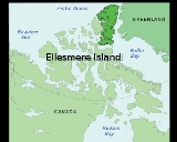
Ellesmere Island
Encyclopedia
Ellesmere Island is part of the Qikiqtaaluk Region of the Canadian
territory of Nunavut
. Lying within the Canadian Arctic Archipelago
, it is considered part of the Queen Elizabeth Islands
, with Cape Columbia
being the most northerly point of land in Canada. It comprises an area of 196235 km² (75,766.8 sq mi), making it the world's tenth largest island and Canada's third largest island. The Arctic Cordillera
mountain system covers much of Ellesmere Island, making it the most mountainous in the Canadian Arctic Archipelago. The Arctic willow is the only woody species to grow on Ellesmere Island.
, muskox, and marine mammal
hunting about 2000–1000 BC.
As was the case for the Dorset
(or Palaeoeskimo) hunters and the pioneering Neoeskimos, the Post-Ruin Island and Late Thule
culture Inuit
used the Bache Peninsula
region extensively both summer and winter until environmental, ecological and possibly social circumstances caused the area to be abandoned. It was the last region in the Canadian High Arctic to be depopulated during the "Little Ice Age
," attesting to its general economic importance as part of the Smith Sound
culture sphere of which it was occasionally a part and sometimes the principal settlement component.
Viking
s from the Greenland
colonies reached Ellesmere Island, Skraeling Island
and Ruin Island during hunting expeditions and trading with the Inuit groups. Unusual structures on Bache peninsula may be the remains of a late-period Dorset stone longhouse.
The first European to sight the island after the height of the "Little Ice Age
" was William Baffin
, in 1616; said "Age" lasted until roughly 1850. Ellesmere Island was named in 1852 by Edward Inglefield
's expedition after Francis Egerton, 1st Earl of Ellesmere
. The American
expedition led by Adolphus Greely
in 1881 crossed the island from east to west. The Greely expedition found fossil forests on Ellesmere Island in the late 1880s. Stenkul Fiord was first explored in 1902 by Per Schei, a member of Otto Sverdrup
's 2nd Norwegian Polar Expedition.
The Ellesmere Ice Shelf
was documented by the British Arctic Expedition
of 1875–76, in which Lieutenant Pelham Aldrich
's party went from Cape Sheridan
(82°28′N 61°30′W) west to Cape Alert (82°16′N 85°33′W), including the Ward Hunt Ice Shelf
. In 1906 Robert Peary
led an expedition in northern Ellesmere Island, from Cape Sheridan along the coast to the western side of Nansen Sound
(93°W). During Peary's expedition, the Ice Shelf was continuous; a modern estimate is that it covered 8900 km² (3,436.3 sq mi).
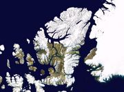
(formerly Ellesmere Island National Park Reserve), which includes seven fjord
s and a variety of glacier
s, as well as Lake Hazen
, North America's largest lake north of the Arctic Circle
. Barbeau Peak
, the highest mountain in Nunavut (2616 m (8,582.7 ft)) is located in the British Empire Range
on Ellesmere Island. The most northern mountain range
in the world, the Challenger Mountains
, is located in the northeast region of the island. The northern lobe of the island is called Grant Land
.
In July 2007, a study noted the disappearance of habitat for waterfowl, invertebrates, and algae on Ellesmere Island. According to John P. Smol of Queen's University
in Kingston, Ontario
, and Marianne S. V. Douglas of the University of Alberta
in Edmonton
, warming conditions and evaporation have caused low water levels and changes in the chemistry of ponds and wetlands in the area. The researchers noted that "In the 1980s they often needed to wear hip waders to make their way to the ponds...while by 2006 the same areas were dry enough to burn."
along the central-east side of the island, along with substantial ice cover in Northern Ellesmere Island. The northwest coast of Ellesmere Island was covered by a massive, 500 km (310.7 mi) long ice shelf
until the 20th century. The Ellesmere Ice Shelf was reduced by 90 percent in the twentieth century due to climate change
, leaving the separate Alfred Ernest
, Ayles, Milne, Ward Hunt, and Markham
Ice Shelves. A 1986 survey of Canadian ice shelves found that 48 km² (18.5 sq mi) 3.3 km³ (0.791712103394146 cu mi) of ice calved from the Milne
and Ayles
ice shelves between 1959 and 1974. The Ward Hunt Ice Shelf, the largest remaining section of thick (>10 m, >30 ft) landfast sea ice along the northern coastline of Ellesmere Island, lost 600 km (372.8 mi) of ice in a massive calving in 1961-1962. It further decreased by 27% in thickness (13 m (42.7 ft)) between 1967 and 1999.
.jpg) The breakup of the Ellesmere Ice Shelves has continued in the 21st century: the Ward Ice Shelf experienced a major breakup during summer 2002; the Ayles Ice Shelf calved entirely on August 13, 2005; the largest breakoff of the ice shelf in 25 years, it may pose a threat to the oil industry in the Beaufort Sea
The breakup of the Ellesmere Ice Shelves has continued in the 21st century: the Ward Ice Shelf experienced a major breakup during summer 2002; the Ayles Ice Shelf calved entirely on August 13, 2005; the largest breakoff of the ice shelf in 25 years, it may pose a threat to the oil industry in the Beaufort Sea
. The piece is 66 km² (25.5 sq mi). In April 2008, it was discovered that the Ward Hunt shelf was fractured into dozens of deep, multi-faceted cracks and in September 2008 the Markham shelf (50 km2 / 20 square miles) completely broke off to become floating sea-ice.
described the Paleocene
-Eocene
(ca. 55 Ma) fossil
forest in the Stenkul Fiord sediments. The Stenkul Fiord site represents a series of deltaic swamp
and floodplain
forests. The trees stood for at least 400 years. Individual stumps and stems of >1 m (>3 ft) diameter were abundant, and are identified as Metasequoia
and possibly Glyptostrobus
. Well preserved Pliocene
peats containing abundant vertebrate and plant macrofossils characteristic of a boreal forest have been reported from Strathcona Fiord
.
In 2006, University of Chicago
paleontologist
Neil Shubin
and Academy of Natural Sciences
paleontologist Ted Daeschler
reported the discovery of the fossil of a Paleozoic
(ca. 375 Ma) fish, named Tiktaalik roseae
, in the former stream bed
s of Ellesmere Island. The fossil exhibits many characteristics of fish, but also indicates a transitional
creature that may be a predecessor of amphibian
s, reptile
s, bird
s, and mammal
s, including human
s.
In 2011, Jason P. Downs and co-authors described the sarcopterygian
Laccognathus embryi
from specimens collected from the same locality that Tiktaalik was found.
insects; specifically, the bumblebee
Bombus polaris
. There is a second species of bumblebee occurring there, Bombus hyperboreus
, which is a parasite in the nests of B. polaris.
(pop. 5), Eureka
(permanent pop. 0, but home to a small temporary population), and Grise Fiord
(pop. 141). Politically, it is part of the Qikiqtaaluk Region.
Canadian Forces Station (CFS) Alert
is the northernmost settlement
in the world. With the end of the Cold War
and the advent of new technologies allowing for remote interpretation of data, the overwintering population has been reduced to 50.
Eureka, which is the second northernmost settlement in the world, consists of three areas, "Eureka Aerodrome" which includes "Fort Eureka" (the quarters for military personnel maintaining the island's communications equipment), the Environment Canada
Weather Station and the Polar Environmental Atmospheric Research Laboratory (PEARL), formally the Arctic Stratospheric Ozone (AStrO) Observatory.
Canada
Canada is a North American country consisting of ten provinces and three territories. Located in the northern part of the continent, it extends from the Atlantic Ocean in the east to the Pacific Ocean in the west, and northward into the Arctic Ocean...
territory of Nunavut
Nunavut
Nunavut is the largest and newest federal territory of Canada; it was separated officially from the Northwest Territories on April 1, 1999, via the Nunavut Act and the Nunavut Land Claims Agreement Act, though the actual boundaries had been established in 1993...
. Lying within the Canadian Arctic Archipelago
Canadian Arctic Archipelago
The Canadian Arctic Archipelago, also known as the Arctic Archipelago, is a Canadian archipelago north of the Canadian mainland in the Arctic...
, it is considered part of the Queen Elizabeth Islands
Queen Elizabeth Islands
The Queen Elizabeth Islands are the northernmost cluster of islands in the Canadian Arctic Archipelago, split between Nunavut and Northwest Territories in Northern Canada.-Geography:...
, with Cape Columbia
Cape Columbia
Cape Columbia is the northernmost point of land of Canada, located on Ellesmere Island in the Qikiqtaaluk Region of Nunavut. It marks the westernmost coastal point of Lincoln Sea in the Arctic Ocean...
being the most northerly point of land in Canada. It comprises an area of 196235 km² (75,766.8 sq mi), making it the world's tenth largest island and Canada's third largest island. The Arctic Cordillera
Arctic Cordillera
The Arctic Cordillera is a vast, deeply dissected chain of mountain ranges extending along the northeastern flank of the Canadian Arctic Archipelago from Ellesmere Island to the northeasternmost part of the Labrador Peninsula in northern Labrador and northern Quebec, Canada...
mountain system covers much of Ellesmere Island, making it the most mountainous in the Canadian Arctic Archipelago. The Arctic willow is the only woody species to grow on Ellesmere Island.
History
The first human inhabitants of Ellesmere Island were small bands drawn to the area for Peary caribouPeary Caribou
The Peary Caribou is a caribou subspecies found in the high Arctic islands of Canada's Nunavut and Northwest territories. They are the smallest of the North American caribou, with the females weighing an average of 60 kg and the males 110 kg...
, muskox, and marine mammal
Marine mammal
Marine mammals, which include seals, whales, dolphins, and walruses, form a diverse group of 128 species that rely on the ocean for their existence. They do not represent a distinct biological grouping, but rather are unified by their reliance on the marine environment for feeding. The level of...
hunting about 2000–1000 BC.
As was the case for the Dorset
Dorset culture
The Dorset culture was a Paleo-Eskimo culture that preceded the Inuit culture in Arctic North America. It has been defined as having four phases, with distinct technology related to the people's hunting and tool making...
(or Palaeoeskimo) hunters and the pioneering Neoeskimos, the Post-Ruin Island and Late Thule
Thule people
The Thule or proto-Inuit were the ancestors of all modern Inuit. They developed in coastal Alaska by AD 1000 and expanded eastwards across Canada, reaching Greenland by the 13th century. In the process, they replaced people of the earlier Dorset culture that had previously inhabited the region...
culture Inuit
Inuit
The Inuit are a group of culturally similar indigenous peoples inhabiting the Arctic regions of Canada , Denmark , Russia and the United States . Inuit means “the people” in the Inuktitut language...
used the Bache Peninsula
Bache Peninsula
Bache Peninsula is a geological formation in Canada, on Ellesmere Island in Nunavut. The peninsula is considered a cape, meaning that it is a headland that dramatically affects the ocean currents...
region extensively both summer and winter until environmental, ecological and possibly social circumstances caused the area to be abandoned. It was the last region in the Canadian High Arctic to be depopulated during the "Little Ice Age
Little Ice Age
The Little Ice Age was a period of cooling that occurred after the Medieval Warm Period . While not a true ice age, the term was introduced into the scientific literature by François E. Matthes in 1939...
," attesting to its general economic importance as part of the Smith Sound
Smith Sound
Smith Sound is an uninhabited Arctic sea passage between Greenland and Canada's northernmost island, Ellesmere Island. It links Baffin Bay with Kane Basin and forms part of the Nares Strait....
culture sphere of which it was occasionally a part and sometimes the principal settlement component.
Viking
Viking
The term Viking is customarily used to refer to the Norse explorers, warriors, merchants, and pirates who raided, traded, explored and settled in wide areas of Europe, Asia and the North Atlantic islands from the late 8th to the mid-11th century.These Norsemen used their famed longships to...
s from the Greenland
Greenland
Greenland is an autonomous country within the Kingdom of Denmark, located between the Arctic and Atlantic Oceans, east of the Canadian Arctic Archipelago. Though physiographically a part of the continent of North America, Greenland has been politically and culturally associated with Europe for...
colonies reached Ellesmere Island, Skraeling Island
Skraeling Island
Skraeling Island lies off the east coast of Ellesmere Island in the Canadian territory of Nunavut.-History:The Norse referred to the indigenous peoples they encountered in Greenland and the New World as skræling , and the sagas make it clear that the Norse considered the natives...
and Ruin Island during hunting expeditions and trading with the Inuit groups. Unusual structures on Bache peninsula may be the remains of a late-period Dorset stone longhouse.
The first European to sight the island after the height of the "Little Ice Age
Little Ice Age
The Little Ice Age was a period of cooling that occurred after the Medieval Warm Period . While not a true ice age, the term was introduced into the scientific literature by François E. Matthes in 1939...
" was William Baffin
William Baffin
William Baffin was an English navigator and explorer. Nothing is known of his early life, but it is conjectured that he was born in London of humble origin, and gradually raised himself by his diligence and perseverance...
, in 1616; said "Age" lasted until roughly 1850. Ellesmere Island was named in 1852 by Edward Inglefield
Edward Augustus Inglefield
Sir Edward Augustus Inglefield was a Royal Naval officer who led one of the searches for the missing Arctic explorer John Franklin during the 1850s. In doing so, his expedition charted previously unexplored areas along the northern Canadian coastline, including Baffin Bay, Smith Sound and...
's expedition after Francis Egerton, 1st Earl of Ellesmere
Francis Egerton, 1st Earl of Ellesmere
Francis Egerton, 1st Earl of Ellesmere KG, PC , known as Lord Francis Leveson-Gower until 1833, was a British politician, writer, traveller and patron of the arts...
. The American
United States
The United States of America is a federal constitutional republic comprising fifty states and a federal district...
expedition led by Adolphus Greely
Adolphus Greely
Adolphus Washington Greely , was an American Polar explorer, a United States Army officer and a recipient of the Medal of Honor.-Early military career:...
in 1881 crossed the island from east to west. The Greely expedition found fossil forests on Ellesmere Island in the late 1880s. Stenkul Fiord was first explored in 1902 by Per Schei, a member of Otto Sverdrup
Otto Sverdrup
Otto Neumann Knoph Sverdrup was a Norwegian sailor and Arctic explorer.-Early and personal life:...
's 2nd Norwegian Polar Expedition.
The Ellesmere Ice Shelf
Ellesmere Ice Shelf
The former Ellesmere Ice Shelf was the largest ice shelf in the Arctic, encompassing about of the north coast of Ellesmere Island, Nunavut, Canada. The ice shelf was first documented by the British Arctic Expedition of 1875-76, in which Lieutenant Pelham Aldrich's party went from Cape Sheridan ...
was documented by the British Arctic Expedition
British Arctic Expedition
The British Arctic Expedition of 1875-1876, led by Sir George Strong Nares, was sent by the British Admiralty to attempt to reach the North Pole via Smith Sound. Two ships, HMS Alert and HMS Discovery , sailed from Portsmouth on 29 May 1875...
of 1875–76, in which Lieutenant Pelham Aldrich
Pelham Aldrich
Pelham Aldrich CVO was a Royal Navy officer and explorer, who became Admiral Superintendent of Portsmouth Docks.-Biography:...
's party went from Cape Sheridan
Cape Sheridan
Cape Sheridan is on the northeastern coast of Ellesmere Island, Canada situated on the Lincoln Sea in the Arctic Ocean, on the mouth of Sheridan River, west bank...
(82°28′N 61°30′W) west to Cape Alert (82°16′N 85°33′W), including the Ward Hunt Ice Shelf
Ward Hunt Ice Shelf
The Ward Hunt Ice Shelf is the largest ice shelf in the Arctic, located on the north coast of Ellesmere Island, Nunavut, Canada. During the 20th century the Ellesmere Ice Shelf broke up into six separate shelves, the largest being Ward Hunt...
. In 1906 Robert Peary
Robert Peary
Robert Edwin Peary, Sr. was an American explorer who claimed to have been the first person, on April 6, 1909, to reach the geographic North Pole...
led an expedition in northern Ellesmere Island, from Cape Sheridan along the coast to the western side of Nansen Sound
Nansen Sound
Nansen Sound is an uninhabited strait in Qikiqtaaluk, Nunavut, Canada. It lies between western Grant Land on Ellesmere Island and Axel Heiberg Island. To the east it enters Greely Fiord.-References:...
(93°W). During Peary's expedition, the Ice Shelf was continuous; a modern estimate is that it covered 8900 km² (3,436.3 sq mi).
Geography
Protected areas
More than one-fifth of the island is protected as Quttinirpaaq National ParkQuttinirpaaq National Park
-See also:*List of National Parks of Canada*List of protected areas of Nunavut*Arctic Cordillera-External links:**...
(formerly Ellesmere Island National Park Reserve), which includes seven fjord
Fjord
Geologically, a fjord is a long, narrow inlet with steep sides or cliffs, created in a valley carved by glacial activity.-Formation:A fjord is formed when a glacier cuts a U-shaped valley by abrasion of the surrounding bedrock. Glacial melting is accompanied by rebound of Earth's crust as the ice...
s and a variety of glacier
Glacier
A glacier is a large persistent body of ice that forms where the accumulation of snow exceeds its ablation over many years, often centuries. At least 0.1 km² in area and 50 m thick, but often much larger, a glacier slowly deforms and flows due to stresses induced by its weight...
s, as well as Lake Hazen
Lake Hazen
Lake Hazen is often called the northernmost lake of Canada, in the northern part of Ellesmere Island, Nunavut, but detailed maps show several smaller lakes up to more than farther north on Canada's northernmost island. Turnabout Lake is immediately northeast of the northern end of Hazen lake...
, North America's largest lake north of the Arctic Circle
Arctic Circle
The Arctic Circle is one of the five major circles of latitude that mark maps of the Earth. For Epoch 2011, it is the parallel of latitude that runs north of the Equator....
. Barbeau Peak
Barbeau Peak
Barbeau Peak is a mountain in Qikiqtaaluk, Nunavut, Canada. Located on Ellesmere Island within Quttinirpaaq National Park, it is the highest mountain in Nunavut, and the highest in eastern North America . The mountain was named in 1969 for Dr...
, the highest mountain in Nunavut (2616 m (8,582.7 ft)) is located in the British Empire Range
British Empire Range
The British Empire Range is a mountain range on Ellesmere Island in Nunavut, Canada. The range is one of the most northern ranges in the world and the Arctic Cordillera, surpassed only by the Challenger Mountains which lies immediately to the northwest and the United States Range slightly further...
on Ellesmere Island. The most northern mountain range
Mountain range
A mountain range is a single, large mass consisting of a succession of mountains or narrowly spaced mountain ridges, with or without peaks, closely related in position, direction, formation, and age; a component part of a mountain system or of a mountain chain...
in the world, the Challenger Mountains
Challenger Mountains
The Challenger Mountains are a mountain range on Ellesmere Island in Nunavut, Canada. The range is the most northern range in the world and of the Arctic Cordillera. The highest mountain in the range is Commonwealth Mountain...
, is located in the northeast region of the island. The northern lobe of the island is called Grant Land
Grant Land
Grant Land is the northern lobe of Ellesmere Island, Nunavut, Canada. Situated on the north coast, Cape Columbia, is the northernmost point of Canada, only 770 km from the North Pole, and was used as the final point on land for Peary's North Pole expedition in 1909.At its highest point, it is ...
.
In July 2007, a study noted the disappearance of habitat for waterfowl, invertebrates, and algae on Ellesmere Island. According to John P. Smol of Queen's University
Queen's University
Queen's University, , is a public research university located in Kingston, Ontario, Canada. Founded on 16 October 1841, the university pre-dates the founding of Canada by 26 years. Queen's holds more more than of land throughout Ontario as well as Herstmonceux Castle in East Sussex, England...
in Kingston, Ontario
Kingston, Ontario
Kingston, Ontario is a Canadian city located in Eastern Ontario where the St. Lawrence River flows out of Lake Ontario. Originally a First Nations settlement called "Katarowki," , growing European exploration in the 17th Century made it an important trading post...
, and Marianne S. V. Douglas of the University of Alberta
University of Alberta
The University of Alberta is a public research university located in Edmonton, Alberta, Canada. Founded in 1908 by Alexander Cameron Rutherford, the first premier of Alberta and Henry Marshall Tory, its first president, it is widely recognized as one of the best universities in Canada...
in Edmonton
Edmonton
Edmonton is the capital of the Canadian province of Alberta and is the province's second-largest city. Edmonton is located on the North Saskatchewan River and is the centre of the Edmonton Capital Region, which is surrounded by the central region of the province.The city and its census...
, warming conditions and evaporation have caused low water levels and changes in the chemistry of ponds and wetlands in the area. The researchers noted that "In the 1980s they often needed to wear hip waders to make their way to the ponds...while by 2006 the same areas were dry enough to burn."
Glaciers and ice caps
Large portions of Ellesmere Island are covered with glaciers and ice, with Manson Icefield and Sydkap in the south; Prince of Wales Icefield and Agassiz Ice CapAgassiz Ice Cap
Agassiz Ice Cap is an ice cap on the northern coast of Ellesmere Island, Nunavut, Canada.-References:...
along the central-east side of the island, along with substantial ice cover in Northern Ellesmere Island. The northwest coast of Ellesmere Island was covered by a massive, 500 km (310.7 mi) long ice shelf
Ice shelf
An ice shelf is a thick, floating platform of ice that forms where a glacier or ice sheet flows down to a coastline and onto the ocean surface. Ice shelves are only found in Antarctica, Greenland and Canada. The boundary between the floating ice shelf and the grounded ice that feeds it is called...
until the 20th century. The Ellesmere Ice Shelf was reduced by 90 percent in the twentieth century due to climate change
Climate change
Climate change is a significant and lasting change in the statistical distribution of weather patterns over periods ranging from decades to millions of years. It may be a change in average weather conditions or the distribution of events around that average...
, leaving the separate Alfred Ernest
Alfred Ernest Ice Shelf
The Alfred Ernest Ice Shelf is an ice shelf on the north-west part of Ellesmere Island, Canada. This ice mass is one of four remaining ice shelves on the island.This ice shelf lies between Alert Point and Cape Woods on Wootton Peninsula...
, Ayles, Milne, Ward Hunt, and Markham
Markham Ice Shelf
The Markham Ice Shelf was one of five major ice shelves in Canada, all located on the northern coast of Ellesmere Island, Nunavut. The ice shelf broke off from the coast in early August 2008, becoming adrift in the Arctic Ocean. At the time, the 4,500 year old ice shelf was in size, nearly the...
Ice Shelves. A 1986 survey of Canadian ice shelves found that 48 km² (18.5 sq mi) 3.3 km³ (0.791712103394146 cu mi) of ice calved from the Milne
Milne Ice Shelf
The Milne Ice Shelf, a fragment of the former Ellesmere Ice Shelf, is located in Qikiqtaaluk Region, Nunavut, Canada. It is the second largest ice shelf in the Arctic Ocean...
and Ayles
Ayles Ice Shelf
The Ayles Ice Shelf was one of six major ice shelves in Canada, all located on the northern coast of Ellesmere Island, Nunavut. The ice shelf broke off from the coast on August 13, 2005, forming a giant ice island thick and measuring around by in size . The oldest ice in the ice shelf is...
ice shelves between 1959 and 1974. The Ward Hunt Ice Shelf, the largest remaining section of thick (>10 m, >30 ft) landfast sea ice along the northern coastline of Ellesmere Island, lost 600 km (372.8 mi) of ice in a massive calving in 1961-1962. It further decreased by 27% in thickness (13 m (42.7 ft)) between 1967 and 1999.
Beaufort Sea
The Beaufort Sea is a marginal sea of the Arctic Ocean, located north of the Northwest Territories, the Yukon, and Alaska, west of Canada's Arctic islands. The sea is named after hydrographer Sir Francis Beaufort...
. The piece is 66 km² (25.5 sq mi). In April 2008, it was discovered that the Ward Hunt shelf was fractured into dozens of deep, multi-faceted cracks and in September 2008 the Markham shelf (50 km2 / 20 square miles) completely broke off to become floating sea-ice.
Paleontology
Schei and later NathorstAlfred Gabriel Nathorst
Alfred Gabriel Nathorst was a Swedish Arctic explorer, geologist and palaeobotanist. Nathorst was born in Väderbrunn outside Nyköping and died in Stockholm.-Biography:He was born on November 7, 1850....
described the Paleocene
Paleocene
The Paleocene or Palaeocene, the "early recent", is a geologic epoch that lasted from about . It is the first epoch of the Palaeogene Period in the modern Cenozoic Era...
-Eocene
Eocene
The Eocene Epoch, lasting from about 56 to 34 million years ago , is a major division of the geologic timescale and the second epoch of the Paleogene Period in the Cenozoic Era. The Eocene spans the time from the end of the Palaeocene Epoch to the beginning of the Oligocene Epoch. The start of the...
(ca. 55 Ma) fossil
Fossil
Fossils are the preserved remains or traces of animals , plants, and other organisms from the remote past...
forest in the Stenkul Fiord sediments. The Stenkul Fiord site represents a series of deltaic swamp
River delta
A delta is a landform that is formed at the mouth of a river where that river flows into an ocean, sea, estuary, lake, reservoir, flat arid area, or another river. Deltas are formed from the deposition of the sediment carried by the river as the flow leaves the mouth of the river...
and floodplain
Floodplain
A floodplain, or flood plain, is a flat or nearly flat land adjacent a stream or river that stretches from the banks of its channel to the base of the enclosing valley walls and experiences flooding during periods of high discharge...
forests. The trees stood for at least 400 years. Individual stumps and stems of >1 m (>3 ft) diameter were abundant, and are identified as Metasequoia
Metasequoia
Metasequoia is a fast-growing, deciduous tree, and the sole living species, Metasequoia glyptostroboides, is one of three species of conifers known as redwoods. It is native to the Sichuan-Hubei region of China. Although the least tall of the redwoods, it grows to at least 200 feet in height...
and possibly Glyptostrobus
Glyptostrobus
Glyptostrobus, is a small genus of conifers in the family Cupressaceae. The sole living species, Glyptostrobus pensilis, is native to subtropical southeastern China, from Fujian west to southeast Yunnan, and also very locally in northern Vietnam and Borikhamxai Province of eastern Lao PDR near the...
. Well preserved Pliocene
Pliocene
The Pliocene Epoch is the period in the geologic timescale that extends from 5.332 million to 2.588 million years before present. It is the second and youngest epoch of the Neogene Period in the Cenozoic Era. The Pliocene follows the Miocene Epoch and is followed by the Pleistocene Epoch...
peats containing abundant vertebrate and plant macrofossils characteristic of a boreal forest have been reported from Strathcona Fiord
Strathcona Fiord
Strathcona Fiord is a fiord on the west central coast of Ellesmere Island, the most northern island within the Canadian Arctic Archipelago, Nunavut, Canada.- Geography :...
.
In 2006, University of Chicago
University of Chicago
The University of Chicago is a private research university in Chicago, Illinois, USA. It was founded by the American Baptist Education Society with a donation from oil magnate and philanthropist John D. Rockefeller and incorporated in 1890...
paleontologist
Paleontology
Paleontology "old, ancient", ὄν, ὀντ- "being, creature", and λόγος "speech, thought") is the study of prehistoric life. It includes the study of fossils to determine organisms' evolution and interactions with each other and their environments...
Neil Shubin
Neil Shubin
Neil Shubin is an American paleontologist, evolutionary biologist and popular science writer. He is the Robert R. Bensley Professor of Organismal Biology and Anatomy, Associate Dean of Organismal Biology and Anatomy and Professor on the Committee of Evolutionary Biology at the University of...
and Academy of Natural Sciences
Academy of Natural Sciences
The Academy of Natural Sciences of Drexel University, formerly Academy of Natural Sciences of Philadelphia, is the oldest natural science research institution and museum in the New World...
paleontologist Ted Daeschler
Ted Daeschler
Ted Daeschler is an American vertebrate paleontologist and Associate Curator and Chair of Vertebrate Biology at the Academy of Natural Sciences in Philadelphia...
reported the discovery of the fossil of a Paleozoic
Paleozoic
The Paleozoic era is the earliest of three geologic eras of the Phanerozoic eon, spanning from roughly...
(ca. 375 Ma) fish, named Tiktaalik roseae
Tiktaalik
Tiktaalik is a genus of extinct sarcopterygian from the late Devonian period, with many features akin to those of tetrapods . It is an example from several lines of ancient sarcopterygian "fish" developing adaptations to the oxygen-poor shallow-water habitats of its time, which led to the...
, in the former stream bed
Stream bed
A stream bed is the channel bottom of a stream, river or creek; the physical confine of the normal water flow. The lateral confines or channel margins, during all but flood stage, are known as the stream banks or river banks. In fact, a flood occurs when a stream overflows its banks and flows onto...
s of Ellesmere Island. The fossil exhibits many characteristics of fish, but also indicates a transitional
Transitional fossil
A transitional fossil is any fossilized remains of a lifeform that exhibits characteristics of two distinct taxonomic groups. A transitional fossil is the fossil of an organism near the branching point where major individual lineages diverge...
creature that may be a predecessor of amphibian
Amphibian
Amphibians , are a class of vertebrate animals including animals such as toads, frogs, caecilians, and salamanders. They are characterized as non-amniote ectothermic tetrapods...
s, reptile
Reptile
Reptiles are members of a class of air-breathing, ectothermic vertebrates which are characterized by laying shelled eggs , and having skin covered in scales and/or scutes. They are tetrapods, either having four limbs or being descended from four-limbed ancestors...
s, bird
Bird
Birds are feathered, winged, bipedal, endothermic , egg-laying, vertebrate animals. Around 10,000 living species and 188 families makes them the most speciose class of tetrapod vertebrates. They inhabit ecosystems across the globe, from the Arctic to the Antarctic. Extant birds range in size from...
s, and mammal
Mammal
Mammals are members of a class of air-breathing vertebrate animals characterised by the possession of endothermy, hair, three middle ear bones, and mammary glands functional in mothers with young...
s, including human
Human
Humans are the only living species in the Homo genus...
s.
In 2011, Jason P. Downs and co-authors described the sarcopterygian
Sarcopterygii
The Sarcopterygii or lobe-finned fishes – sometimes considered synonymous with Crossopterygii constitute a clade of the bony fishes, though a strict classification would include the terrestrial vertebrates...
Laccognathus embryi
Laccognathus embryi
Laccognathus embryi is an extinct species of porolepiform lobe-finned fish recovered from Ellesmere Island, Canada. It existed during the Frasnian age of the Late Devonian epoch .-Discovery:...
from specimens collected from the same locality that Tiktaalik was found.
Insect ecology
Ellesmere Island is noted as being the northernmost occurrence of eusocialEusociality
Eusociality is a term used for the highest level of social organization in a hierarchical classification....
insects; specifically, the bumblebee
Bumblebee
A bumble bee is any member of the bee genus Bombus, in the family Apidae. There are over 250 known species, existing primarily in the Northern Hemisphere although they are common in New Zealand and in the Australian state of Tasmania.Bumble bees are social insects that are characterised by black...
Bombus polaris
Bombus polaris
Bombus polaris is an Arctic bumblebee species.-Distribution:The bumblebee has a circumpolar distribution, found in Canada, arctic Alaska, Arctic islands , northern Scandinavia and Russia .-Characteristics:The bumblebee has dense fur that slows heat loss...
. There is a second species of bumblebee occurring there, Bombus hyperboreus
Bombus hyperboreus
Bombus hyperboreus is an Arctic bumblebee species with a circumpolar distribution, found in arctic Canada, Alaska, Greenland, northern Scandinavia and Russia....
, which is a parasite in the nests of B. polaris.
Population
In 2006, the population of Ellesmere Island was recorded as 146. There are three settlements on Ellesmere Island, AlertAlert, Nunavut
Alert, in the Qikiqtaaluk Region, Nunavut, Canada, is the northernmost permanently inhabited place in the world, from the North Pole. It takes its name from HMS Alert, which wintered east of the present station, off what is now Cape Sheridan, in 1875–1876.Alert was reported to have five permanent...
(pop. 5), Eureka
Eureka, Nunavut
Eureka is a small research base on Fosheim Peninsula, Ellesmere Island, Qikiqtaaluk Region, in the Canadian territory of Nunavut. It is located on the north side of Slidre Fiord, which enters Eureka Sound farther west. It is the second-northernmost permanent research community in the world. The...
(permanent pop. 0, but home to a small temporary population), and Grise Fiord
Grise Fiord, Nunavut
Grise Fiord, is a small Inuit hamlet in the Qikiqtaaluk Region in the territory of Nunavut, Canada. Despite its low population , it is the largest community on Ellesmere Island...
(pop. 141). Politically, it is part of the Qikiqtaaluk Region.
Canadian Forces Station (CFS) Alert
CFS Alert
Canadian Forces Station Alert, also CFS Alert, is a Canadian Forces signals intelligence intercept facility located in Alert, Nunavut on the northeastern tip of Ellesmere Island, at ....
is the northernmost settlement
Northernmost settlements
Some of the northernmost settlements in the world are:-Larger cities north of the Arctic circle:-See also:*Southernmost settlements*Extreme points of Earth*The world's most northern bagpipe orchestra, city, capital, zoo etc....
in the world. With the end of the Cold War
Cold War
The Cold War was the continuing state from roughly 1946 to 1991 of political conflict, military tension, proxy wars, and economic competition between the Communist World—primarily the Soviet Union and its satellite states and allies—and the powers of the Western world, primarily the United States...
and the advent of new technologies allowing for remote interpretation of data, the overwintering population has been reduced to 50.
Eureka, which is the second northernmost settlement in the world, consists of three areas, "Eureka Aerodrome" which includes "Fort Eureka" (the quarters for military personnel maintaining the island's communications equipment), the Environment Canada
Environment Canada
Environment Canada , legally incorporated as the Department of the Environment under the Department of the Environment Act Environment Canada (EC) (French: Environnement Canada), legally incorporated as the Department of the Environment under the Department of the Environment Act Environment...
Weather Station and the Polar Environmental Atmospheric Research Laboratory (PEARL), formally the Arctic Stratospheric Ozone (AStrO) Observatory.
See also
- Nansen SoundNansen SoundNansen Sound is an uninhabited strait in Qikiqtaaluk, Nunavut, Canada. It lies between western Grant Land on Ellesmere Island and Axel Heiberg Island. To the east it enters Greely Fiord.-References:...
- Ellesmere Island VolcanicsEllesmere Island VolcanicsThe Ellesmere Island Volcanics are a Late Cretaceous volcanic group of volcanoes and lava flows in the Qikiqtaaluk Region of northern Ellesmere Island, Nunavut, Canada.Ellesmere Island Volcanics are part of the Arctic Cordillera...
- Lomonosov RidgeLomonosov RidgeThe Lomonosov Ridge is an unusual underwater ridge of continental crust in the Arctic Ocean. It spans 1800 km from the New Siberian Islands, as it is part of Eurasia, over the central part of the ocean to Ellesmere Island of the Canadian Arctic Archipelago. The width of the Lomonosov Ridge varies...
- Ledoyom (Ice body)
- Strathcona FiordStrathcona FiordStrathcona Fiord is a fiord on the west central coast of Ellesmere Island, the most northern island within the Canadian Arctic Archipelago, Nunavut, Canada.- Geography :...
Further reading
- Dick, Lyle. Muskox Land Ellesmere Island in the Age of Contact. Calgary: University of Calgary Press, 2001. ISBN 1552380505
- Eberle, Jaelyn, and Malcolm McKenna. 2002. "Early Eocene Leptictida, Pantolesta, Creodonta, Carnivora, and Mesonychidae (Mammalia) from the Eureka Sound Group, Ellesmere Island, Nunavut". Canadian Journal of Earth Sciences. 39: 899-910.
- Kobalenko, Jerry. The Horizontal Everest Extreme Journeys on Ellesmere Island. New York, NY: Soho, 2002. ISBN 1569472661
- Manseau, Micheline, Lyle Dick, and Natasha Lyons. People, caribou, and muskoxen on northern Ellesmere Island historical interactions and population ecology, ca. 4300 BP to present = Humains, caribous et boeuf musqués dans le nord de l'Île d'Ellesmere : interactions historiques et écologie des populations, v. 4 300 AA jusqu'à aujourd'hui = Inuit, tuttuit, ammalu umimmait aisuittup qikiqsuluata uannaqpasinggani : uatsiarisnisait qanuiliusninggit ammalu amiruninnginnit nasainiq uumajurnit, ca 4300 BP maannamut. [Ottawa]: Parks Canada = Parcs Canada, 2005. ISBN 066268835X
- Schledermann, Peter, and Karen Margrethe McCullough. Late Thule Culture Developments on the Central East Coast of Ellesmere Island. Copenhagen: Danish Polar Center, 2003. ISBN 8790369645
External links
- Mountains on Ellesmere Island
- Detailed map, northern Ellesmere Island, including named capes, points, bays, and offshore islands by Geoffrey Hattersley-SmithGeoffrey Hattersley-SmithGeoffrey Francis Hattersley-Smith D.Phil, FRSC, FAINA is an English born geologist and glaciologist. He attended Winchester College in Hampshire and graduated from New College, Oxford....