
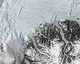
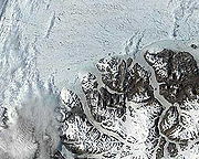
Ayles Ice Shelf
Encyclopedia

Canada
Canada is a North American country consisting of ten provinces and three territories. Located in the northern part of the continent, it extends from the Atlantic Ocean in the east to the Pacific Ocean in the west, and northward into the Arctic Ocean...
, all located on the northern coast of Ellesmere Island
Ellesmere Island
Ellesmere Island is part of the Qikiqtaaluk Region of the Canadian territory of Nunavut. Lying within the Canadian Arctic Archipelago, it is considered part of the Queen Elizabeth Islands, with Cape Columbia being the most northerly point of land in Canada...
, Nunavut
Nunavut
Nunavut is the largest and newest federal territory of Canada; it was separated officially from the Northwest Territories on April 1, 1999, via the Nunavut Act and the Nunavut Land Claims Agreement Act, though the actual boundaries had been established in 1993...
. The ice shelf broke off from the coast on August 13, 2005, forming a giant ice island 37 metres (121.4 ft) thick and measuring around 14 km (8.7 mi) by 5 km (3.1 mi) in size (approximately 66 km² or 25.5 mi (41 km)² in area or 2.6 km³ in volume). The oldest ice in the ice shelf is believed to be over 3,000 years old. The ice shelf was located at (83°1.5′N 77°33.5′W), approximately 800 km (497.1 mi) south of the North Pole
North Pole
The North Pole, also known as the Geographic North Pole or Terrestrial North Pole, is, subject to the caveats explained below, defined as the point in the northern hemisphere where the Earth's axis of rotation meets its surface...
.
The Ayles Ice Shelf, like the nearby Mount Ayles
Mount Ayles
Mount Ayles is a mountain located on Ellesmere Island, Nunavut, Canada. It forms part of the border of the Quttinirpaaq National Park. Like the nearby Ayles Ice Shelf, the mountain was named by the Geological Survey of Canada in 1965 for Petty Officer Adam Ayles of HMS Alert, who was serving in the...
, was named for the Arctic explorer Adam Ayles
Adam Ayles
Adam Ayles was an Arctic explorer who served under George Nares as the Petty Officer of HMS Alert in the British Arctic Expedition.The Ayles Ice Shelf and Mount Ayles were both named after him....
, who served under George Nares
George Nares
Vice-Admiral Sir George Strong Nares KCB FRS was a British naval officer and Arctic explorer. He commanded both the Challenger Expedition and the British Arctic Expedition, and was highly thought of a leader and a scientific explorer...
as the Petty Officer of HMS Alert in the British Arctic Expedition
British Arctic Expedition
The British Arctic Expedition of 1875-1876, led by Sir George Strong Nares, was sent by the British Admiralty to attempt to reach the North Pole via Smith Sound. Two ships, HMS Alert and HMS Discovery , sailed from Portsmouth on 29 May 1875...
. A 1986 survey of Canadian ice shelves found that 48 square km (3.3 cubic km) of ice calved from the Milne and Ayles ice shelves between 1959 and 1974.
Ayles Ice Island
On August 13, 2005, the entire shelf broke clear from the coast of Ellesmere, forming a new ice island. It is believed to be the largest shelf breakup of its kind in Canada in over 30 years. The event registered on seismometersSeismology
Seismology is the scientific study of earthquakes and the propagation of elastic waves through the Earth or through other planet-like bodies. The field also includes studies of earthquake effects, such as tsunamis as well as diverse seismic sources such as volcanic, tectonic, oceanic,...
in northern Canada, and it was verified via satellite imagery.
The breakup was noticed by the Canadian Ice Service at the time that it occurred, but it took a further 16 months to fully reconstruct the breakup sequence from past satellite images captured by MODIS
MODIS
The Moderate-resolution Imaging Spectroradiometer is a payload scientific instrument launched into Earth orbit by NASA in 1999 on board the Terra Satellite, and in 2002 on board the Aqua satellite...
, to determine the climatic conditions during the event, and for the event to garner public attention. The event, which some have linked to global warming
Global warming
Global warming refers to the rising average temperature of Earth's atmosphere and oceans and its projected continuation. In the last 100 years, Earth's average surface temperature increased by about with about two thirds of the increase occurring over just the last three decades...
, is similar to the 2002 breakup of the Larsen B Ice Shelf in Antarctica.
The speed of the breakup is also remarkable; it took less than an hour. Canada has lost approximately 90% of its ice shelves in the last hundred years.
Within days of the breakup, the former shelf had drifted over 50 km (31.1 mi) from Ellesmere Island before freezing into the sea ice for the winter. It was estimated in May, 2007 to be between 138 and 148 feet (45.1 m) thick, on average.
The freed segment of the ice shelf, known as Ayles Ice Island, drifted southwesterly for two years, and in January 2007 accelerated into the open Arctic Ocean, causing concern for oil rig
Oil platform
An oil platform, also referred to as an offshore platform or, somewhat incorrectly, oil rig, is a lаrge structure with facilities to drill wells, to extract and process oil and natural gas, and to temporarily store product until it can be brought to shore for refining and marketing...
operators in the Beaufort Sea
Beaufort Sea
The Beaufort Sea is a marginal sea of the Arctic Ocean, located north of the Northwest Territories, the Yukon, and Alaska, west of Canada's Arctic islands. The sea is named after hydrographer Sir Francis Beaufort...
north of Prudhoe Bay. In August 2007, however, the island became wedged into the Sverdrup Inlet of the Queen Elizabeth Islands
Queen Elizabeth Islands
The Queen Elizabeth Islands are the northernmost cluster of islands in the Canadian Arctic Archipelago, split between Nunavut and Northwest Territories in Northern Canada.-Geography:...
. Although scientists initially thought it was likely to remain there for some time, possibly permanently, it soon afterwards broke into two parts and resumed movement.
There is concern that the ice islands may become a hazard for ships and oil platforms.
While the formation of the Ayles Ice Island received widespread attention at the time due to the availability of satellite imagery and the ability of news media and scientists to visit the island, it was by no means unprecedented. On August 14, 1946, a U.S. Air Force patrol plane flying 300 miles (482.8 km) north of Port Barrow, Alaska spotted an ice island, dubbed T-1, which was 15 miles (24.1 km) wide and 18 miles (29 km) across. It was estimated to be from 240 and 1600 feet (487.7 m) thick, with sides that rose from 30 to 200 above the sea surface - much larger than the Ayles Ice Island. Over the following three years, it travelled 1500 miles (2,414 km) along the Beaufort Eddy, a slow-moving ocean current that flows eastward across the North Pole, then back west along the coast. In 1950, the U.S. Air Force 58th Reconnaissance Squadron was ordered to find T-1, and any other ice islands in the Arctic. In July, 1950, T-2 was found, a roughly rectangular ice island estimated to be 20 miles (32.2 km) by 20 miles (32.2 km) by dimension. In 1947, a joint U.S.-Canadian expedition had noted and photographed a fresh water sea formation in the sea off Ellesmere Island. From a photographic examination of its ridges, T-2 was discovered to be the same ice island spotted off Ellesmere Island in 1947. Later in July 1950, the U.S. Air Force found T-3, a kidney-shaped island, nine by four and a half miles. This was later occupied for brief periods in the early and mid 1950s. In August 1951, T-1 was relocated, nestled along the coast of Ellesmere Island. It is not known how long prior T-1, T-2, and T-3 had been formed, but it is believed they had calved from ice shelves on northern Ellesmere Island. There are an estimated 80 ice islands in Canada's High Arctic, most of them part of the pack ice that covers the region.
Between August 1961 and April 1962, almost 600 square kilometres of ice broke away from the Ward Hunt Ice Shelf. This event was attributed to tidal and seismic events.
External links
- 16 image slideshow of satellite and radar images showing the breakup (CBC News, requires Adobe FlashAdobe FlashAdobe Flash is a multimedia platform used to add animation, video, and interactivity to web pages. Flash is frequently used for advertisements, games and flash animations for broadcast...
). - Ayles Ice Shelf breakup images and media resources by Dr. Luke Copland, University of Ottawa
- Ayles Ice Shelf breakup background information by the Canadian Ice Service
- Arctic ice shelf collapse poses risk: expert, CBC news, Thursday, December 28, 2006, 6:39 PM ET
- Huge ice shelf breaks free in Canada's far north by Jeffrey Jones, ReutersReutersReuters is a news agency headquartered in New York City. Until 2008 the Reuters news agency formed part of a British independent company, Reuters Group plc, which was also a provider of financial market data...
, 29 Dec 2006 21:22:06 GMT - Huge Arctic ice break discovered, BBC newsBBC NewsBBC News is the department of the British Broadcasting Corporation responsible for the gathering and broadcasting of news and current affairs. The department is the world's largest broadcast news organisation and generates about 120 hours of radio and television output each day, as well as online...
, Friday, 29 December 2006, 22:52 GMT - Giant Ice Shelf Breaks Off in Canadian Arctic by Richard A. Lovett, National Geographic News, December 29, 2006
- Ice-shelf collapse, climate change, and habitat loss in the Canadian high Arctic F. W. Vincent, J. A. E. Gibson & M. O. Jeffries. Polar Record 37 (201): 133-142 (2001).
- Science team lands on Ice Island, BBC News, Tuesday 22 May 2007