

Cape Columbia
Encyclopedia
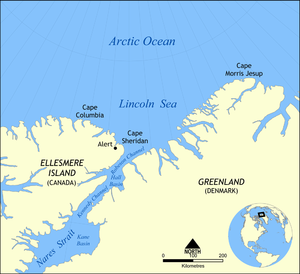
Canada
Canada is a North American country consisting of ten provinces and three territories. Located in the northern part of the continent, it extends from the Atlantic Ocean in the east to the Pacific Ocean in the west, and northward into the Arctic Ocean...
, located on Ellesmere Island
Ellesmere Island
Ellesmere Island is part of the Qikiqtaaluk Region of the Canadian territory of Nunavut. Lying within the Canadian Arctic Archipelago, it is considered part of the Queen Elizabeth Islands, with Cape Columbia being the most northerly point of land in Canada...
in the Qikiqtaaluk Region of Nunavut
Nunavut
Nunavut is the largest and newest federal territory of Canada; it was separated officially from the Northwest Territories on April 1, 1999, via the Nunavut Act and the Nunavut Land Claims Agreement Act, though the actual boundaries had been established in 1993...
. It marks the westernmost coastal point of Lincoln Sea
Lincoln Sea
Lincoln Sea is a body of water in the Arctic Ocean, stretching from Cape Columbia, Canada, in the west to Cape Morris Jesup, Greenland, in the east. The northern limit is defined as the great circle line between those two headlands. It is covered with sea ice throughout the year, the thickest sea...
in the Arctic Ocean
Arctic Ocean
The Arctic Ocean, located in the Northern Hemisphere and mostly in the Arctic north polar region, is the smallest and shallowest of the world's five major oceanic divisions...
. It is the world's northernmost point of land outside Greenland
Greenland
Greenland is an autonomous country within the Kingdom of Denmark, located between the Arctic and Atlantic Oceans, east of the Canadian Arctic Archipelago. Though physiographically a part of the continent of North America, Greenland has been politically and culturally associated with Europe for...
and the distance to the North Pole
North Pole
The North Pole, also known as the Geographic North Pole or Terrestrial North Pole, is, subject to the caveats explained below, defined as the point in the northern hemisphere where the Earth's axis of rotation meets its surface...
is 769 km (477.8 mi).
Human History
Cape Columbia was first reached in 1876 by Pelham AldrichPelham Aldrich
Pelham Aldrich CVO was a Royal Navy officer and explorer, who became Admiral Superintendent of Portsmouth Docks.-Biography:...
, a lieutenant with the expedition (1875-76)
British Arctic Expedition
The British Arctic Expedition of 1875-1876, led by Sir George Strong Nares, was sent by the British Admiralty to attempt to reach the North Pole via Smith Sound. Two ships, HMS Alert and HMS Discovery , sailed from Portsmouth on 29 May 1875...
of British explorer George Nares
George Nares
Vice-Admiral Sir George Strong Nares KCB FRS was a British naval officer and Arctic explorer. He commanded both the Challenger Expedition and the British Arctic Expedition, and was highly thought of a leader and a scientific explorer...
.
Peary
Robert PearyRobert Peary
Robert Edwin Peary, Sr. was an American explorer who claimed to have been the first person, on April 6, 1909, to reach the geographic North Pole...
chose the Cape as the location for the northernmost depot of his final attempt to reach the Pole (1909), not only for its proximity but because it lay far enough west to be out of the ice current setting down Robeson Channel
Robeson Channel
Robeson Channel is a body of water lying between Greenland and Canada's northernmost island, Ellesmere Island. It is the most northerly part of Nares Strait, linking Hall Basin to the south with the Arctic Ocean to the north....
. From Cape Columbia his party planned to strike straight north over the ice of the Arctic Sea. His winter camp and ship the Roosevelt were situated some 90 mi (144.8 km) southeast, at Cape Sheridan
Cape Sheridan
Cape Sheridan is on the northeastern coast of Ellesmere Island, Canada situated on the Lincoln Sea in the Arctic Ocean, on the mouth of Sheridan River, west bank...
near Alert
Alert, Nunavut
Alert, in the Qikiqtaaluk Region, Nunavut, Canada, is the northernmost permanently inhabited place in the world, from the North Pole. It takes its name from HMS Alert, which wintered east of the present station, off what is now Cape Sheridan, in 1875–1876.Alert was reported to have five permanent...
.
Peary's sledge divisions left the Roosevelt from February 15 to 22, 1909, rendezvoused at Cape Columbia, and on March 1 the expedition left Cape Columbia, heading across the Arctic Ocean for the Pole. The 84th parallel was crossed on March 18, the 86th on March 23. The final position reached by Peary is doubtful, as the speeds he claimed after departure of the last independent witness are suspicious at best. Peary returned to land at Cape Columbia again on April 23.