

Geography of Nunavut
Encyclopedia
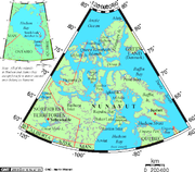
The Canadian
territory of Nunavut
covers about 1.9 million square kilometres ( 733,594 sq. miles) of land and water including part of the mainland, most of the Arctic Islands, and all of the islands in Hudson Bay
, James Bay
, and Ungava Bay
(including the Belcher Islands
) which belonged to the Northwest Territories. This makes it the fifth largest subnational entity in the world. If Nunavut were a country, it would rank 13th in area, after the Democratic Republic of the Congo
. Nunavut has land borders with the Northwest Territories on several islands as well as the mainland, and a tiny land border with Newfoundland and Labrador
on Killiniq Island
.
 The mountain
s on the easternmost coasts of Nunavut are part of the Arctic Cordillera
which stretches from northernmost Ellesmere Island
to the northernmost tip of Labrador
.
The highest point is Barbeau Peak
mountain range in Canada and offers some of the world's most spectacular scenery.
Geologically, Nunavut lies on the Canadian Shield
, with very thin soil lying on top of the bedrock, and many bare outcrops. The multitude of rivers and lakes in the entire region is caused by the watersheds of the area being so young and in a state of sorting themselves out with the added effect of post-glacial rebound. Virtually all of Nunavut's rivers drain into the Hudson Bay
or the Arctic Ocean
.
Arctic tundra
(Koppen climate classification
ET) covers virtually all of Nunavut, the only exceptions being a tiny area in the extreme southwest near the "four corners" alluded to above, where a marginal taiga
forest exists, and small zones of permanent ice caps, found on some of the larger Arctic Islands (especially Baffin
, Devon
and Ellesmere
) at sites having a relatively high elevation. Nunavut's vegetation is partially composed of rare berries, lichen
s, Arctic Willow
s, moss
, tough grass, and small willow shrubs.
'
, Nunavut has a population of approximately 30,000, of whom around 85% are native peoples, primarily Inuit
. Nunavut's small and sparse population makes it unlikely the territory will be granted provincial status in the foreseeable future, although this may change if the Yukon
, which is only marginally more populous, becomes a province.
File:Dragon Cliffs, Nunavut.jpg|Dragon Cliffs
File:Barbeau Peak, Nunavut.jpg|Barbeau Peak
File:Wfm graham island nunavut.jpg|Graham Island
File:Kazan_Falls_Nunavut.jpg|Kazan Falls on the Kazan River
File:Resolute Bay, Nunavut (2008) A Photo A Day (July 19, 2008).jpg|Resolute Bay
File:Byam Martin Mountains 11 1997-08-05.jpg|Sirmilik National Park
File:Kimmirut.jpg|Kimmirut
File:Grise Fiord, Nunavut (2008).jpg|A road in Grise Fiord
Canada
Canada is a North American country consisting of ten provinces and three territories. Located in the northern part of the continent, it extends from the Atlantic Ocean in the east to the Pacific Ocean in the west, and northward into the Arctic Ocean...
territory of Nunavut
Nunavut
Nunavut is the largest and newest federal territory of Canada; it was separated officially from the Northwest Territories on April 1, 1999, via the Nunavut Act and the Nunavut Land Claims Agreement Act, though the actual boundaries had been established in 1993...
covers about 1.9 million square kilometres ( 733,594 sq. miles) of land and water including part of the mainland, most of the Arctic Islands, and all of the islands in Hudson Bay
Hudson Bay
Hudson Bay , sometimes called Hudson's Bay, is a large body of saltwater in northeastern Canada. It drains a very large area, about , that includes parts of Ontario, Quebec, Saskatchewan, Alberta, most of Manitoba, southeastern Nunavut, as well as parts of North Dakota, South Dakota, Minnesota,...
, James Bay
James Bay
James Bay is a large body of water on the southern end of Hudson Bay in Canada. Both bodies of water extend from the Arctic Ocean. James Bay borders the provinces of Quebec and Ontario; islands within the bay are part of Nunavut...
, and Ungava Bay
Ungava Bay
Ungava Bay is a large bay in northeastern Canada separating Nunavik from Baffin Island. The bay is shaped like a rounded square with a side length of about and has an area of approximately...
(including the Belcher Islands
Belcher Islands
The Belcher Islands are an archipelago in Qikiqtaaluk Region, Nunavut, Canada. Located in Hudson Bay, the Belcher Islands are spread out over almost . The hamlet of Sanikiluaq is on the north coast of Flaherty Island and is the southernmost in Nunavut. Along with Flaherty Island, the other large...
) which belonged to the Northwest Territories. This makes it the fifth largest subnational entity in the world. If Nunavut were a country, it would rank 13th in area, after the Democratic Republic of the Congo
Democratic Republic of the Congo
The Democratic Republic of the Congo is a state located in Central Africa. It is the second largest country in Africa by area and the eleventh largest in the world...
. Nunavut has land borders with the Northwest Territories on several islands as well as the mainland, and a tiny land border with Newfoundland and Labrador
Newfoundland and Labrador
Newfoundland and Labrador is the easternmost province of Canada. Situated in the country's Atlantic region, it incorporates the island of Newfoundland and mainland Labrador with a combined area of . As of April 2011, the province's estimated population is 508,400...
on Killiniq Island
Killiniq Island
Killiniq Island is a small, remote island in northeastern Canada. Located at the extreme northern tip of Labrador between Ungava Bay and the Labrador Sea, it is notable in that it contains the only land border between Nunavut territory and the province of Newfoundland and Labrador...
.
Physical geography
Mountain
Image:Himalaya_annotated.jpg|thumb|right|The Himalayan mountain range with Mount Everestrect 58 14 160 49 Chomo Lonzorect 200 28 335 52 Makalurect 378 24 566 45 Mount Everestrect 188 581 920 656 Tibetan Plateaurect 250 406 340 427 Rong River...
s on the easternmost coasts of Nunavut are part of the Arctic Cordillera
Arctic Cordillera
The Arctic Cordillera is a vast, deeply dissected chain of mountain ranges extending along the northeastern flank of the Canadian Arctic Archipelago from Ellesmere Island to the northeasternmost part of the Labrador Peninsula in northern Labrador and northern Quebec, Canada...
which stretches from northernmost Ellesmere Island
Ellesmere Island
Ellesmere Island is part of the Qikiqtaaluk Region of the Canadian territory of Nunavut. Lying within the Canadian Arctic Archipelago, it is considered part of the Queen Elizabeth Islands, with Cape Columbia being the most northerly point of land in Canada...
to the northernmost tip of Labrador
Labrador
Labrador is the distinct, northerly region of the Canadian province of Newfoundland and Labrador. It comprises the mainland portion of the province, separated from the island of Newfoundland by the Strait of Belle Isle...
.
The highest point is Barbeau Peak
Barbeau Peak
Barbeau Peak is a mountain in Qikiqtaaluk, Nunavut, Canada. Located on Ellesmere Island within Quttinirpaaq National Park, it is the highest mountain in Nunavut, and the highest in eastern North America . The mountain was named in 1969 for Dr...
mountain range in Canada and offers some of the world's most spectacular scenery.
Geologically, Nunavut lies on the Canadian Shield
Canadian Shield
The Canadian Shield, also called the Laurentian Plateau, or Bouclier Canadien , is a vast geological shield covered by a thin layer of soil that forms the nucleus of the North American or Laurentia craton. It is an area mostly composed of igneous rock which relates to its long volcanic history...
, with very thin soil lying on top of the bedrock, and many bare outcrops. The multitude of rivers and lakes in the entire region is caused by the watersheds of the area being so young and in a state of sorting themselves out with the added effect of post-glacial rebound. Virtually all of Nunavut's rivers drain into the Hudson Bay
Hudson Bay
Hudson Bay , sometimes called Hudson's Bay, is a large body of saltwater in northeastern Canada. It drains a very large area, about , that includes parts of Ontario, Quebec, Saskatchewan, Alberta, most of Manitoba, southeastern Nunavut, as well as parts of North Dakota, South Dakota, Minnesota,...
or the Arctic Ocean
Arctic Ocean
The Arctic Ocean, located in the Northern Hemisphere and mostly in the Arctic north polar region, is the smallest and shallowest of the world's five major oceanic divisions...
.
Arctic tundra
Tundra
In physical geography, tundra is a biome where the tree growth is hindered by low temperatures and short growing seasons. The term tundra comes through Russian тундра from the Kildin Sami word tūndâr "uplands," "treeless mountain tract." There are three types of tundra: Arctic tundra, alpine...
(Koppen climate classification
Köppen climate classification
The Köppen climate classification is one of the most widely used climate classification systems. It was first published by Crimea German climatologist Wladimir Köppen in 1884, with several later modifications by Köppen himself, notably in 1918 and 1936...
ET) covers virtually all of Nunavut, the only exceptions being a tiny area in the extreme southwest near the "four corners" alluded to above, where a marginal taiga
Taiga
Taiga , also known as the boreal forest, is a biome characterized by coniferous forests.Taiga is the world's largest terrestrial biome. In North America it covers most of inland Canada and Alaska as well as parts of the extreme northern continental United States and is known as the Northwoods...
forest exists, and small zones of permanent ice caps, found on some of the larger Arctic Islands (especially Baffin
Baffin Island
Baffin Island in the Canadian territory of Nunavut is the largest island in the Canadian Arctic Archipelago, the largest island in Canada and the fifth largest island in the world. Its area is and its population is about 11,000...
, Devon
Devon Island
Devon Island , claimed to be the largest uninhabited island on Earth, is located in Baffin Bay, Qikiqtaaluk Region, Nunavut, Canada. It is one of the larger members of the Canadian Arctic Archipelago, the second-largest of the Queen Elizabeth Islands, Canada's sixth largest island, and the 27th...
and Ellesmere
Ellesmere Island
Ellesmere Island is part of the Qikiqtaaluk Region of the Canadian territory of Nunavut. Lying within the Canadian Arctic Archipelago, it is considered part of the Queen Elizabeth Islands, with Cape Columbia being the most northerly point of land in Canada...
) at sites having a relatively high elevation. Nunavut's vegetation is partially composed of rare berries, lichen
Lichen
Lichens are composite organisms consisting of a symbiotic organism composed of a fungus with a photosynthetic partner , usually either a green alga or cyanobacterium...
s, Arctic Willow
Arctic Willow
Salix arctica is a tiny creeping willow . It is adapted to survive in harsh Arctic and subarctic environments, and has a circumpolar distribution round the Arctic Ocean.-Distribution:...
s, moss
Moss
Mosses are small, soft plants that are typically 1–10 cm tall, though some species are much larger. They commonly grow close together in clumps or mats in damp or shady locations. They do not have flowers or seeds, and their simple leaves cover the thin wiry stems...
, tough grass, and small willow shrubs.
Demographics
See also List of communities in Nunavut, Regions of NunavutRegions of Nunavut
The regions of Nunavut serve as census divisions, although Statistics Canada has tended to use the names "Baffin Region" for Qikiqtaaluk Region and "Keewatin Region" for Kivalliq Region. Though the regions have no autonomous governments, Nunavut's territorial government services are highly...
'
, Nunavut has a population of approximately 30,000, of whom around 85% are native peoples, primarily Inuit
Inuit
The Inuit are a group of culturally similar indigenous peoples inhabiting the Arctic regions of Canada , Denmark , Russia and the United States . Inuit means “the people” in the Inuktitut language...
. Nunavut's small and sparse population makes it unlikely the territory will be granted provincial status in the foreseeable future, although this may change if the Yukon
Yukon
Yukon is the westernmost and smallest of Canada's three federal territories. It was named after the Yukon River. The word Yukon means "Great River" in Gwich’in....
, which is only marginally more populous, becomes a province.
| Municipality | 2001 | 1999 |
|---|---|---|
| Iqaluit | 5,236 | 4,220 |
| Rankin Inlet | 2,177 | 2,058 |
| Arviat | 1,899 | 1,559 |
| Baker Lake Baker Lake, Nunavut Baker Lake , is a hamlet in the Kivalliq Region, in Nunavut on mainland Canada. Located inland from Hudson Bay, it is near the nation's geographical centre, and is notable for being the Canadian Arctic's sole inland community... |
1,507 | 1,385 |
| Cambridge Bay | 1,309 | 1,351 |
| Igloolik | 1,286 | 1,174 |
| Pangnirtung Pangnirtung, Nunavut Pangnirtung is an Inuit hamlet, Qikiqtaaluk Region, in the Canadian territory of Nunavut, located on Baffin Island. As of the 2006 census the population was 1,325, an increase of 3.8% from the 2001 census... |
1,276 | 1,243 |
| Pond Inlet Pond Inlet, Nunavut Pond Inlet is a small, predominantly Inuit community in the Qikiqtaaluk Region of Nunavut, Canada and is located at the top of Baffin Island. As of the 2006 census the population was 1,315, an increase of 7.8% from the 2001 census making it the largest of the four hamlets above the 72nd parallel... |
1,220 | 1,154 |
| Kugluktuk Kugluktuk, Nunavut Kugluktuk is a hamlet located at the mouth of the Coppermine River in the Kitikmeot Region of Nunavut, Canada, on Coronation Gulf, southwest of Victoria Island... |
1,212 | 1,201 |
| Cape Dorset Cape Dorset, Nunavut Cape Dorset is an Inuit hamlet located on Dorset Island near Foxe Peninsula at the southern tip of Baffin Island in the Qikiqtaaluk Region of Nunavut, Canada... |
1,148 | 1,118 |
Gallery
File:Dragon Cliffs, Nunavut.jpg|Dragon Cliffs
File:Barbeau Peak, Nunavut.jpg|Barbeau Peak
File:Wfm graham island nunavut.jpg|Graham Island
File:Kazan_Falls_Nunavut.jpg|Kazan Falls on the Kazan River
File:Resolute Bay, Nunavut (2008) A Photo A Day (July 19, 2008).jpg|Resolute Bay
File:Byam Martin Mountains 11 1997-08-05.jpg|Sirmilik National Park
File:Kimmirut.jpg|Kimmirut
File:Grise Fiord, Nunavut (2008).jpg|A road in Grise Fiord