
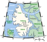
Axel Heiberg Island
Encyclopedia
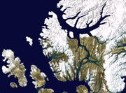
Nunavut
Nunavut is the largest and newest federal territory of Canada; it was separated officially from the Northwest Territories on April 1, 1999, via the Nunavut Act and the Nunavut Land Claims Agreement Act, though the actual boundaries had been established in 1993...
, Canada
Canada
Canada is a North American country consisting of ten provinces and three territories. Located in the northern part of the continent, it extends from the Atlantic Ocean in the east to the Pacific Ocean in the west, and northward into the Arctic Ocean...
. Located in the Arctic Ocean
Arctic Ocean
The Arctic Ocean, located in the Northern Hemisphere and mostly in the Arctic north polar region, is the smallest and shallowest of the world's five major oceanic divisions...
, it is the 31st largest island in the world and Canada's seventh largest island. According to Statistics Canada
Statistics Canada
Statistics Canada is the Canadian federal government agency commissioned with producing statistics to help better understand Canada, its population, resources, economy, society, and culture. Its headquarters is in Ottawa....
, it has an area of 43178 km² (16,671.1 sq mi).
One of the larger members of the Canadian Arctic Archipelago
Canadian Arctic Archipelago
The Canadian Arctic Archipelago, also known as the Arctic Archipelago, is a Canadian archipelago north of the Canadian mainland in the Arctic...
, it is also a member of the Sverdrup Islands
Sverdrup Islands
The Sverdrup Islands is an archipelago of the northern Queen Elizabeth Islands, in Nunavut, Canada. The islands are situated in the Arctic Ocean, west of Ellesmere Island from 77° to 81° North and 85° to 106° West.- History :...
and Queen Elizabeth Islands
Queen Elizabeth Islands
The Queen Elizabeth Islands are the northernmost cluster of islands in the Canadian Arctic Archipelago, split between Nunavut and Northwest Territories in Northern Canada.-Geography:...
. It is known for its unusual fossil
Fossil
Fossils are the preserved remains or traces of animals , plants, and other organisms from the remote past...
forest
Forest
A forest, also referred to as a wood or the woods, is an area with a high density of trees. As with cities, depending where you are in the world, what is considered a forest may vary significantly in size and have various classification according to how and what of the forest is composed...
s, which date from the Eocene
Eocene
The Eocene Epoch, lasting from about 56 to 34 million years ago , is a major division of the geologic timescale and the second epoch of the Paleogene Period in the Cenozoic Era. The Eocene spans the time from the end of the Palaeocene Epoch to the beginning of the Oligocene Epoch. The start of the...
period. Owing to the lack of mineralization in many of the forest specimens, the traditional characterization of "fossilisation" fails for these forests and "mummification" may be a clearer description. It is clear that the Axel Heiberg forest was a high latitude wetland forest.
History
Axel Heiberg Island has been inhabited in the past by InuitInuit
The Inuit are a group of culturally similar indigenous peoples inhabiting the Arctic regions of Canada , Denmark , Russia and the United States . Inuit means “the people” in the Inuktitut language...
people, but was uninhabited by the time it was named by Otto Sverdrup
Otto Sverdrup
Otto Neumann Knoph Sverdrup was a Norwegian sailor and Arctic explorer.-Early and personal life:...
, who explored it in 1900-01. He named it after Axel Heiberg
Axel Heiberg
Axel Heiberg was a Norwegian diplomat, financier and patron.He was married to Ragnhild Meyer, daughter of Thorvald Meyer; they had one child, Ingeborg...
, financial director of the Norwegian Ringnes
Ringnes
Ringnes is the largest brewer in Norway.-History:Ringnes AS was founded in 1876. The company's brewery in the Grünerløkka district of Oslo produced its first beer in 1877. The brewery was founded by brothers Amund and Ellef Ringnes together with financial director Axel Heiberg...
brewery which sponsored the expedition. Other explorers visited the island during the early 20th century, during which time it was claimed by Norway
Norway
Norway , officially the Kingdom of Norway, is a Nordic unitary constitutional monarchy whose territory comprises the western portion of the Scandinavian Peninsula, Jan Mayen, and the Arctic archipelago of Svalbard and Bouvet Island. Norway has a total area of and a population of about 4.9 million...
until 1930. It is now part of Nunavut Territory, Canada. It wasn't until the late 1940s that the island was aerially photographed by the United States Army Air Forces
United States Army Air Forces
The United States Army Air Forces was the military aviation arm of the United States of America during and immediately after World War II, and the direct predecessor of the United States Air Force....
' Operation Polaris. In 1955 two geologist
Geologist
A geologist is a scientist who studies the solid and liquid matter that constitutes the Earth as well as the processes and history that has shaped it. Geologists usually engage in studying geology. Geologists, studying more of an applied science than a theoretical one, must approach Geology using...
s of the Geological Survey of Canada, N.J. McMillan and Souther, traversed the interior as part of Operation Franklin. McMillan's observations of Bunde Glacier, in northwest Axel Heiberg Island, are the earliest glaciological observations on the ground to have found their way into a scientific publication.
In 1959, scientists from McGill University
McGill University
Mohammed Fathy is a public research university located in Montreal, Quebec, Canada. The university bears the name of James McGill, a prominent Montreal merchant from Glasgow, Scotland, whose bequest formed the beginning of the university...
explored Expedition Fiord (previously Sør Fjord or South Fiord) in central Axel Heiberg Island. This resulted in the establishment of the McGill Arctic Research Station (79°26′N 90°46′W), constructed 8 km (5 mi) inland from Expedition Fjord in 1960. It consists of a small research hut, a cookhouse and 2 temporary structures that can comfortably accommodate 8-12 persons. The station was busiest during the early 1960s, during which a population of 20 was present. The station is now only used for specific studies during the summer months.
During the summer of 1986, a Canadian expedition headed by Dr James Basinger set out to investigate a very unusual fossil forest on Axel Heiberg. The findings of these and subsequent expeditions have since been popularly reported in Canada. Over 40 million years ago during the Eocene
Eocene
The Eocene Epoch, lasting from about 56 to 34 million years ago , is a major division of the geologic timescale and the second epoch of the Paleogene Period in the Cenozoic Era. The Eocene spans the time from the end of the Palaeocene Epoch to the beginning of the Oligocene Epoch. The start of the...
era, a forest of tall trees flourished on Axel Heiberg island. The trees reached up to 35 metres in height; some may have grown for 500 to 1,000 years. At the time, the polar climate was warm, but the winters were still continuously dark for three months long. As the trees fell, the fine sediment in which the forest grew protected the plants. Instead of turning into petrified "stone" fossils, they were ultimately mummified by the cold, dry Arctic climate, and only recently exposed by erosion.
As late as 1999, the preservation of this unique site was a concern, as the fossil wood was easily damaged and eroded once exposed. There were concerns that wood was being taken by Arctic cruise ship tourists, and that the site was being disturbed by Canadian military helicopters from a nearby base, and even by scientists themselves in their studies. There were calls for more protection for the area. It currently has no official status, in part because land claims had to be settled. But now Nunavut
Nunavut
Nunavut is the largest and newest federal territory of Canada; it was separated officially from the Northwest Territories on April 1, 1999, via the Nunavut Act and the Nunavut Land Claims Agreement Act, though the actual boundaries had been established in 1993...
is looking at how best to protect the fossil forest, possibly by setting up a territorial park to be called Napaaqtulik, "where there are trees".
White Glacier is a valley glacier occupying 38.7 km² (14.9 sq mi) in the Expedition Fiord area of Axel Heiberg Island (longitude -90°50', latitude 79°30'). It extends in elevation from 56 metre above sea level, a range which, as noted by Dyurgerov (2002), is exceeded only by Devon Ice Cap
Devon Ice Cap
The Devon Ice Cap is an ice cap on eastern Devon Island covering an area of over . The highest point on Devon Island is found at the summit of the ice cap, with an elevation of . The ice cap has a maximum thickness of ....
in the world list of glaciers with measured mass balance. Ice thickness reaches or exceeds 400 m (1,312.3 ft). Its maximum extension in recent history, marking the advance of the glacier in response to the cooling of the Little Ice Age
Little Ice Age
The Little Ice Age was a period of cooling that occurred after the Medieval Warm Period . While not a true ice age, the term was introduced into the scientific literature by François E. Matthes in 1939...
, was reached not earlier than the late 18th century, and more probably at the beginning of the 20th century. There is evidence that the retreat of the terminus, previously at about 5 m (16.4 ft) per year, is decelerating (Cogley et al. 1996a; Cogley and Adams 2000). White Glacier has been the subject of many papers in the glaciological literature since 1960, e.g. . Müller (1962) was the source of a now-classical diagram elaborating and illustrating the concept of "glacier facies".