
1954 Atlantic hurricane season
Encyclopedia
The 1954 Atlantic hurricane season caused over $750 million in damage, the most of any season
at the time. The season officially began on June 15, and nine days later the first named storm
developed. Hurricane Alice
developed in the Gulf of Mexico
and moved inland along the Rio Grande
, producing significant precipitation and record flooding that killed 55 people. Activity was slow until late August; only Barbara, a minimal tropical storm, developed in July. In the span of two weeks, hurricanes Carol
and Edna
followed similar paths before striking New England
as a major hurricane
. The latter became the costliest hurricane in Maine's history.
In late September, Tropical Storm Gilda killed 29 people after drenching northern Honduras. A tropical depression in early October was captured by a high-altitude photograph on a rocket, thus producing the first large-scale image of a tropical cyclone. The strongest and deadliest hurricane of the season was Hurricane Hazel
, which killed thousands in Haiti
before striking near the North Carolina
/South Carolina
border in October. It caused heavy damage in the United States before becoming extratropical
and affecting Ontario
. Intense rainfall affected Toronto
with severe flooding, leaving significant damage. The season officially ended on November 15, although another hurricane named Alice developed on December 30 to the northeast of the Lesser Antilles; it lasted until January 6 of the following year. In total, there were 11 tropical storms, 8 hurricanes, and 3 major hurricanes.
 The hurricane season officially began on June 15, when the United States Weather Bureau
in Miami, Florida
began 24 hour operations. The agency, under the direction of Grady Norton
had access to 43 other weather stations across the Atlantic basin. Norton died during the season from a stroke while tracking Hurricane Hazel. Additionally, a group of Hurricane Hunters
planes were put on standby for the season, able to be flown out into storms and collect data. During the season, there were eight named storms
, as well as an unnamed hurricane and a tropical depression. The season officially ended on November 15, although an unnamed tropical storm formed a day later. In addition, Tropical Storm Alice developed on December 31, the latest a tropical cyclone has developed in the calendar year.
Cumulatively, tropical cyclones left 193 deaths and $756 million in damage, becoming the costliest hurricane season at the time. The season was one of six to have three major hurricanes strike the country, along with 2005
(which had four), 1893
, 1909
, 1933
, and 2004
. Two of the major hurricanes – Carol and Edna – struck New England; this occurred despite an average of only 5–10 New England hurricanes per century. Carol struck Connecticut
as a hurricane and left widespread heavy damage. Only ten days later, Edna became the costliest hurricane in Maine's history. The third major hurricane, Hazel, was the strongest hurricane of the season, attaining winds of 150 mph (240 km/h). Unusually, no tropical cyclones affected Florida.
The season's activity was reflected with a cumulative accumulated cyclone energy
(ACE) rating of 113, which is categorized as being "above normal". ACE is, broadly speaking, a measure of the power of the hurricane multiplied by the length of time it existed, so storms that last a long time, as well as particularly strong hurricanes, have high ACEs. ACE is only calculated for full advisories on tropical systems at or exceeding 34 knots (39 mph, 63 km/h) or tropical storm strength. Subtropical cyclone
s are excluded from the total.
On June 26, Alice dissipated, although the system dropped torrential rainfall across southern Texas and northeastern Mexico. The maximum rainfall officially peaked at 24.07 in (611.4 mm) near Pandale, Texas
, concentrated in an area around the Pecos River
. High precipitation accumulations occurred in areas that had seen little rains in three years. This led to significant flooding along the Pecos River that produced "probably the greatest rate of runoff for a watershed of [that] size in the United States", as reported by the International Boundary and Water Commission
. Ozona, Texas
sustained the most impact, estimated at $2 million in damage (1954 USD). Downstream, the Rio Grande
rose to the highest level since 1865, which flooded seven towns on either side of the border; Eagle Pass, Texas
was flooded with 8 ft (2.4 m) of water. Overall there were at least 55 deaths.
. A map of the low pressure area
s forming in July 1954 indicated that the system originated near the Mississippi Delta
and tracked southward. After forming, the depression tracked northwestward, intensifying into Tropical Storm Barbara early on July 28. Maximum sustained wind
s reached 45 mph (75 km/h), although a tanker offshore named the Henry M. Dawes reported wind gusts of 60 mph (96.6 km/h). Officials at the United States Weather Bureau posted a storm warning
from Cameron
to Burrwood, Louisiana
, and also advised small craft to remain at port along the entire northern Gulf Coast. Without intensifying further, Barbara made landfall near Vermilion Bay
, Louisiana
on July 29, dissipating the next day over Texas. The storm dropped heavy rainfall along its path, including over 2 in (50.8 mm) in New Orleans. The rains caused flooding as well as some damage to the rice crop. However, the Monthly Weather Review
yearly summary described the precipitation as "far more beneficial than damaging". There was no wind damage.
with winds between 75 mph (120 km/h) to 125 mph (200 km/h). It intensified further as it accelerated, striking eastern Long Island
as upper Category 2 or a Category 3 hurricane. Carol made its final landfall on Old Saybrook, Connecticut
late on August 31. Within a few hours, the hurricane became extratropical over New Hampshire
, which later dissipated over Quebec
.
In North Carolina, hurricane-force winds left minor damage to houses, estimated around $228,000. Rains from Carol alleviated drought conditions in the Washington, D.C.
area. On Long Island, the storm surge
flooded the Montauk Highway
with 4 ft (1.2 m) of water about a mile across. High winds left 275,000 homes without power, and damage totaled $3 million on the island.
The hurricane moved ashore in Connecticut shortly after high tide, producing a storm surge of 10–15 ft (3–4.5 m) from New London
eastward. The surge in Narragansett Bay
reached 14.4 ft (4.4 m), which surpassed that of the 1938 New England hurricane, which flooded downtown Providence
with 12 feet (3.7 m) of water. In New London, rainfall peaked around 6 in (152.4 mm). The hurricane produced winds of over 115 mph (185.1 km/h) in Connecticut and Rhode Island, including a record-high gust of 135 mph (215 km/h) at Block Island
. Widespread areas were left without power from eastern Connecticut to southern Massachusetts. Further north, Hurricane Carol downed hundreds of trees, as well as destroying widespread apple groves and corn fields. It became the costliest natural disaster in the state's history, only to be surpassed by Hurricane Edna ten days later. Across New England, the hurricane destroyed about 4,000 homes, 3,500 cars, and 3,000 boats. Damage totaled $460 million, and there were 60 deaths. In neighboring Canada, high rains caused flooding while strong winds downed trees and power lines.
spawned a tropical depression on August 31 to the northwest of Puerto Rico
. It moved rapidly north-northwestward, intensifying into Tropical Storm Dolly later that day and into a hurricane early on September 1. Early in the storm's duration, the U.S. Weather Bureau noted the potential for Dolly to affect the same areas of New England that Hurricane Carol struck just days prior. However, the hurricane turned to the north away from land. The Hurricane Hunters estimated maximum sustained winds of 100–115 mph (155–185 km/h) on September 2 after the storm passed about halfway between the Outer Banks and Bermuda
. Dolly turned to the northeast on September 2 and became extratropical later that day to the south of Nova Scotia
. It was tracked until September 4, until it was last located to the north of the Azores. There was no reported damage.
. On September 11, Edna became one of only three major hurricanes to strike Massachusetts, along with a hurricane in 1869
and the 1938 Long Island hurricane. The hurricane later moved ashore near the border between Maine and New Brunswick around the time it became extratropical. The remnants persisted a few more days before dissipating south of Greenland.
Early in its duration, Edna produced high seas and gale force winds in the Bahamas, but there was no damage there. Hurricane force winds occurred in the Outer Banks, although damage was minor. As it passed New England, Edna produced a 6 ft (1.8 m) storm surge during a high tide, which caused severe flooding in Martha's Vineyard
, Nantucket, and Cape Cod. Wind gusts peaked at 120 mph (193.1 km/h) on Martha's Vineyard, and the strong winds across the region left widespread power outages. The hurricane dropped additional heavy rainfall to areas affected by Carol, resulting in flooding in Massachusetts and Rhode Island. In Long Island and New England, the hurricane left over $42 million in damage and 20 deaths, only 11 days after Carol affected the same area. About a third of the damage occurred in Maine, becoming the costliest hurricane on record in the state. Hurricane force winds extended into Canada, causing $6 million in damage (1954 CAD
), mostly from crop damage. There was one death in Nova Scotia.
on September 11. Given the name Florence, the storm moved generally west-southwestward with a small radius of maximum wind
s. Hurricane Hunters reported winds of 65 mph (104.6 km/h), although winds were estimated to have reached minimal hurricane force, or 75 mph (120 km/h). Before the storm moved ashore, officials in Veracruz evacuated residents from low-lying areas, and overall about 90,000 people left their homes. On September 12, Florence moved ashore between Tuxpan, and Nautla, Veracruz and quickly dissipated. The hurricane flooded coastal cities with up to 3 ft (0.9144 m) of water, cutting off communications throughout the state. Damage was heaviest around Poza Rica, primarily from the destruction of banana plantations. Monetary damage was estimated around $1.5 million (1954 USD), and there were five reported deaths.
about halfway between Jamaica and Colombia. A small storm, it moved westward throughout its duration. On September 26, Gilda attained peak winds of 70 mph (110 km/h) while nearing northeastern Honduras
. The storm paralleled the coastline a short distance offshore, maintaining its intensity before hitting and later dissipating over Belize
on September 27. While moving just offshore the coast of Honduras, Gilda dropped intense rainfall, which flooding about 680 mi2 (1760 km2 of land along the Chamelecon
and Ulúa
rivers. The waters caused the widespread destruction of banana plantations and houses, leaving about 3,000 people homeless. Honduras President Juan Manuel Gálvez
appealed for aid from the United States. In response, U.S. Air Force planes flew food, medicine, rafts, and water purification tablets to the most affected regions. A total of 29 people were killed in Honduras. When Gilda made its landfall in Belize, it left little property damage and no deaths.
. The depression weakened as it across southern Texas and dropped heavy rainfall. Brownsville recorded over 3 in (75 mm) in a 45 minute period, as well as about 6 in (152.4 mm) in six hours. The rainfall rates of about an inch per hour was the heaviest since June 1950. The depression also moved ashore with high waves and tides.
When the system reached the Big Bend
region on October 5 it reintensified slightly. Around that time, the United States Navy
conducted a rocket test from White Sands, New Mexico
; this was despite that such tests were rarely performed when the skies were cloudy. The rocket took an unintended photograph of the depression from an altitude of about 100 miles (160 km), which became the first such large-scale image of a tropical cyclone. The depression later moved into New Mexico and dropped additional rainfall, interacting with an approaching cold front
. Flooding was reported around Roswell
, as well as along the Pecos River
system. Rainfall in the state peaked at 9.8 in (248.9 mm) in Canton, New Mexico. The system dissipated on October 7.
before striking the United States near the border between North
and South Carolina
, as a Category 4 hurricane. After causing 95 fatalities in the U.S., Hazel struck Canada as an extratropical storm, raising the death toll by 81 people, mostly in Toronto
.
Hazel formed on October 5 just east of the Windward Islands
and intensified into a major hurricane while crossing the Caribbean Sea
. In Haiti, Hazel destroyed 40% of the coffee trees and 50% of the cacao crop, affecting the economy for several years to come. The hurricane made landfall in the Carolinas, and destroyed most waterfront dwellings near its point of impact. It affected several more states, including Delaware
, Maryland
, New Jersey
, New York
, Pennsylvania
, Virginia
, and West Virginia
, bringing gusts near 100 mph (160 km/h) and causing $308 million (1954 USD) in damage.
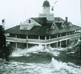
When Hazel arrived in Ontario, rivers and streams passing through the Greater Toronto Area
overflowed their banks, causing severe flooding. As a result, many residential areas located in floodplains, such as the Raymore Drive
area, were subsequently converted to parkland. In Canada alone, over C$
135 million (2009: $1.1 billion) of damage was incurred. Hazel was particularly destructive in Toronto
, as a result of a combination of a lack of experience in dealing with tropical storms and the storm's unexpected retention of power. Hazel had traveled 680 mi (1,094.4 km) over land, but while approaching Canada, it had merged with an existing powerful cold front. The storm stalled over the Greater Toronto Area, and although it was now extratropical, it remained as powerful as a category 1 hurricane. To help with the cleanup, 800 members of the military were summoned, and a Hurricane Relief Fund was established that distributed $5.1 million (2009: $41.7 million) in aid.
of low pressure in the central Atlantic Ocean in an area of unusually favorable conditions. The storm moved southwestward and gradually strengthened to reach hurricane status. It persisted into the following calendar year, passing through the Leeward Islands
on January 2. Alice reached peak winds of 80 mph (130 km/h) before encountering cold air and turning to the southeast. It dissipated on January 6 over the southeastern Caribbean Sea
.
Alice produced heavy rainfall and moderately strong winds across several islands along its path. Saba and Anguilla
were affected the most, with total damage amounting to $623,500 (1955 USD). Operationally, lack of definitive data prevented the U.S. Weather Bureau from declaring the system a hurricane until January 2. It received the name Alice in early 1955, though re-analysis of the data supported extending its track to the previous year, resulting in two tropical cyclones of the same name in one season. It was one of only two storms to span two calendar years, along with Tropical Storm Zeta in 2005 and 2006.
. Names that were not assigned are marked in gray.
, but was retroactively retired when the modern naming system was introduced. Edna was reused in 1968 and retired. Hazel was not re-used and was retired.
Atlantic hurricane season
The Atlantic hurricane season is the period in a year when hurricanes usually form in the Atlantic Ocean. Tropical cyclones in the North Atlantic are called hurricanes, tropical storms, or tropical depressions. In addition, there have been several storms over the years that have not been fully...
at the time. The season officially began on June 15, and nine days later the first named storm
Tropical cyclone naming
Tropical cyclones have officially been named since 1945 and are named for a variety of reasons, which include to facilitate communications between forecasters and the public when forecasts, watches, and warnings are issued. Names also reduce confusion about what storm is being described, as more...
developed. Hurricane Alice
Hurricane Alice (June 1954)
Hurricane Alice was a Category 1 hurricane that struck extreme northern Mexico and southern Texas in June 1954, causing at least 55 deaths. It formed in the Bay of Campeche on June 24, and maintained its intensity as it progressed inland between Texas and Mexico...
developed in the Gulf of Mexico
Gulf of Mexico
The Gulf of Mexico is a partially landlocked ocean basin largely surrounded by the North American continent and the island of Cuba. It is bounded on the northeast, north and northwest by the Gulf Coast of the United States, on the southwest and south by Mexico, and on the southeast by Cuba. In...
and moved inland along the Rio Grande
Rio Grande
The Rio Grande is a river that flows from southwestern Colorado in the United States to the Gulf of Mexico. Along the way it forms part of the Mexico – United States border. Its length varies as its course changes...
, producing significant precipitation and record flooding that killed 55 people. Activity was slow until late August; only Barbara, a minimal tropical storm, developed in July. In the span of two weeks, hurricanes Carol
Hurricane Carol
Hurricane Carol was among the worst tropical cyclones to affect the New England region of the United States. It developed from a tropical wave near the Bahamas on August 25, 1954, and gradually strengthened as it moved northwestward. On August 27, Carol intensified to reach winds of , but weakened...
and Edna
Hurricane Edna
Hurricane Edna was a deadly and destructive major hurricane that impacted the United States East Coast in September of the 1954 Atlantic hurricane season. It was one of two hurricanes to strike Massachusetts in that year, the other being Hurricane Carol...
followed similar paths before striking New England
New England
New England is a region in the northeastern corner of the United States consisting of the six states of Maine, New Hampshire, Vermont, Massachusetts, Rhode Island, and Connecticut...
as a major hurricane
Tropical cyclone scales
Tropical systems are officially ranked on one of several tropical cyclone scales according to their maximum sustained winds and in what oceanic basin they are located...
. The latter became the costliest hurricane in Maine's history.
In late September, Tropical Storm Gilda killed 29 people after drenching northern Honduras. A tropical depression in early October was captured by a high-altitude photograph on a rocket, thus producing the first large-scale image of a tropical cyclone. The strongest and deadliest hurricane of the season was Hurricane Hazel
Hurricane Hazel
Hurricane Hazel was the deadliest and costliest hurricane of the 1954 Atlantic hurricane season. The storm killed as many as 1,000 people in Haiti before striking the United States near the border between North and South Carolina, as a Category 4 hurricane...
, which killed thousands in Haiti
Haiti
Haiti , officially the Republic of Haiti , is a Caribbean country. It occupies the western, smaller portion of the island of Hispaniola, in the Greater Antillean archipelago, which it shares with the Dominican Republic. Ayiti was the indigenous Taíno or Amerindian name for the island...
before striking near the North Carolina
North Carolina
North Carolina is a state located in the southeastern United States. The state borders South Carolina and Georgia to the south, Tennessee to the west and Virginia to the north. North Carolina contains 100 counties. Its capital is Raleigh, and its largest city is Charlotte...
/South Carolina
South Carolina
South Carolina is a state in the Deep South of the United States that borders Georgia to the south, North Carolina to the north, and the Atlantic Ocean to the east. Originally part of the Province of Carolina, the Province of South Carolina was one of the 13 colonies that declared independence...
border in October. It caused heavy damage in the United States before becoming extratropical
Extratropical cyclone
Extratropical cyclones, sometimes called mid-latitude cyclones or wave cyclones, are a group of cyclones defined as synoptic scale low pressure weather systems that occur in the middle latitudes of the Earth having neither tropical nor polar characteristics, and are connected with fronts and...
and affecting Ontario
Ontario
Ontario is a province of Canada, located in east-central Canada. It is Canada's most populous province and second largest in total area. It is home to the nation's most populous city, Toronto, and the nation's capital, Ottawa....
. Intense rainfall affected Toronto
Toronto
Toronto is the provincial capital of Ontario and the largest city in Canada. It is located in Southern Ontario on the northwestern shore of Lake Ontario. A relatively modern city, Toronto's history dates back to the late-18th century, when its land was first purchased by the British monarchy from...
with severe flooding, leaving significant damage. The season officially ended on November 15, although another hurricane named Alice developed on December 30 to the northeast of the Lesser Antilles; it lasted until January 6 of the following year. In total, there were 11 tropical storms, 8 hurricanes, and 3 major hurricanes.
Season summary
National Weather Service
The National Weather Service , once known as the Weather Bureau, is one of the six scientific agencies that make up the National Oceanic and Atmospheric Administration of the United States government...
in Miami, Florida
Miami, Florida
Miami is a city located on the Atlantic coast in southeastern Florida and the county seat of Miami-Dade County, the most populous county in Florida and the eighth-most populous county in the United States with a population of 2,500,625...
began 24 hour operations. The agency, under the direction of Grady Norton
Grady Norton
Grady Norton was an American meteorologist. He is widely recognized as the original director of the National Hurricane Center even though that position would not be created during his lifetime....
had access to 43 other weather stations across the Atlantic basin. Norton died during the season from a stroke while tracking Hurricane Hazel. Additionally, a group of Hurricane Hunters
Hurricane Hunters
The Hurricane Hunters are aircraft that fly into tropical cyclones in the North Atlantic Ocean and Northeastern Pacific Ocean for the specific purpose of directly measuring weather data in and around those storms. In the United States, the Air Force, Navy, and NOAA units have all participated in...
planes were put on standby for the season, able to be flown out into storms and collect data. During the season, there were eight named storms
Tropical cyclone naming
Tropical cyclones have officially been named since 1945 and are named for a variety of reasons, which include to facilitate communications between forecasters and the public when forecasts, watches, and warnings are issued. Names also reduce confusion about what storm is being described, as more...
, as well as an unnamed hurricane and a tropical depression. The season officially ended on November 15, although an unnamed tropical storm formed a day later. In addition, Tropical Storm Alice developed on December 31, the latest a tropical cyclone has developed in the calendar year.
Cumulatively, tropical cyclones left 193 deaths and $756 million in damage, becoming the costliest hurricane season at the time. The season was one of six to have three major hurricanes strike the country, along with 2005
2005 Atlantic hurricane season
The 2005 Atlantic hurricane season was the most active Atlantic hurricane season in recorded history, repeatedly shattering numerous records. The impact of the season was widespread and ruinous with an estimated 3,913 deaths and record damage of about $159.2 billion...
(which had four), 1893
1893 Atlantic hurricane season
The 1893 Atlantic hurricane season ran through the summer and the first half of fall in 1893. The 1893 season was fairly active, with 12 tropical storms forming, 10 of which became hurricanes. Of those, 5 became major hurricanes...
, 1909
1909 Atlantic hurricane season
The 1909 Atlantic hurricane season was an average Atlantic hurricane season, officially starting on June 1, 1909, and ending on November 30, 1909, dates which conventionally delimit the period of each year when tropical cyclones tend to form in the Atlantic basin...
, 1933
1933 Atlantic hurricane season
The 1933 Atlantic hurricane season was the second most active Atlantic hurricane season on record, with 21 storms forming during that year in the northwest Atlantic Ocean. The season ran through the summer and the first half of fall in 1933, and was surpassed in total number of tropical cyclones by...
, and 2004
2004 Atlantic hurricane season
The 2004 Atlantic hurricane season officially began on June 1, 2004, and lasted until November 30, 2004. These dates conventionally delimit the period of each year when most tropical cyclones form in the Atlantic basin...
. Two of the major hurricanes – Carol and Edna – struck New England; this occurred despite an average of only 5–10 New England hurricanes per century. Carol struck Connecticut
Connecticut
Connecticut is a state in the New England region of the northeastern United States. It is bordered by Rhode Island to the east, Massachusetts to the north, and the state of New York to the west and the south .Connecticut is named for the Connecticut River, the major U.S. river that approximately...
as a hurricane and left widespread heavy damage. Only ten days later, Edna became the costliest hurricane in Maine's history. The third major hurricane, Hazel, was the strongest hurricane of the season, attaining winds of 150 mph (240 km/h). Unusually, no tropical cyclones affected Florida.
The season's activity was reflected with a cumulative accumulated cyclone energy
Accumulated cyclone energy
Accumulated cyclone energy is a measure used by the National Oceanic and Atmospheric Administration to express the activity of individual tropical cyclones and entire tropical cyclone seasons, particularly the North Atlantic hurricane season. It uses an approximation of the energy used by a...
(ACE) rating of 113, which is categorized as being "above normal". ACE is, broadly speaking, a measure of the power of the hurricane multiplied by the length of time it existed, so storms that last a long time, as well as particularly strong hurricanes, have high ACEs. ACE is only calculated for full advisories on tropical systems at or exceeding 34 knots (39 mph, 63 km/h) or tropical storm strength. Subtropical cyclone
Subtropical cyclone
A subtropical cyclone is a weather system that has some characteristics of a tropical and an extratropical cyclone. As early as the 1950s, meteorologists were unclear whether they should be characterized as tropical or extratropical cyclones. They were officially recognized by the National...
s are excluded from the total.
Hurricane Alice (June)
On June 24, a tropical storm and later hurricane rapidly developed in the western Gulf of Mexico, giving the citizens of southern Texas and northeastern Mexico little time to prepare. Hurricane Alice moved ashore in northeastern Mexico and quickly weakened, producing minor damage and killing one person due to a fallen power line.On June 26, Alice dissipated, although the system dropped torrential rainfall across southern Texas and northeastern Mexico. The maximum rainfall officially peaked at 24.07 in (611.4 mm) near Pandale, Texas
Pandale, Texas
Pandale is a ghost town in Val Verde County, Texas, United States. It is a small town whose current population is smaller than in some previous years. It has been noted as a starting point for canoeing expeditions.-Location and Population:...
, concentrated in an area around the Pecos River
Pecos River
The headwaters of the Pecos River are located north of Pecos, New Mexico, United States, at an elevation of over 12,000 feet on the western slope of the Sangre de Cristo mountain range in Mora County. The river flows for through the eastern portion of that state and neighboring Texas before it...
. High precipitation accumulations occurred in areas that had seen little rains in three years. This led to significant flooding along the Pecos River that produced "probably the greatest rate of runoff for a watershed of [that] size in the United States", as reported by the International Boundary and Water Commission
International Boundary and Water Commission
The International Boundary and Water Commission is an international body created in 1889 by the United States and Mexico to administer the many boundary and water-rights treaties and agreements between the two nations....
. Ozona, Texas
Ozona, Texas
Ozona is a census-designated place in and the county seat of Crockett County, Texas, United States. The population was 3,436 at the 2000 census...
sustained the most impact, estimated at $2 million in damage (1954 USD). Downstream, the Rio Grande
Rio Grande
The Rio Grande is a river that flows from southwestern Colorado in the United States to the Gulf of Mexico. Along the way it forms part of the Mexico – United States border. Its length varies as its course changes...
rose to the highest level since 1865, which flooded seven towns on either side of the border; Eagle Pass, Texas
Eagle Pass, Texas
Eagle Pass is a city in and the county seat of Maverick County The population was 27,183 as of the 2010 census.Eagle Pass borders the city of Piedras Negras, Coahuila, Mexico, which is to the southwest and across the Rio Grande. The Eagle Pass-Piedras Negras Metropolitan Area is one of six...
was flooded with 8 ft (2.4 m) of water. Overall there were at least 55 deaths.
Tropical Storm Barbara
On July 27, a tropical depression developed in the northern Gulf of Mexico, about 100 mi (160 km) south of Grand Isle, LouisianaGrand Isle, Louisiana
Grand Isle is a town in Jefferson Parish, Louisiana, located on a barrier island of the same name in the Gulf of Mexico. The island is at the mouth of Barataria Bay where it meets the gulf. As of the 2000 census, the town population was 1,541; during summers, the population sometimes increases to...
. A map of the low pressure area
Low pressure area
A low-pressure area, or "low", is a region where the atmospheric pressure at sea level is below that of surrounding locations. Low-pressure systems form under areas of wind divergence which occur in upper levels of the troposphere. The formation process of a low-pressure area is known as...
s forming in July 1954 indicated that the system originated near the Mississippi Delta
Mississippi Delta
The Mississippi Delta is the distinctive northwest section of the U.S. state of Mississippi that lies between the Mississippi and Yazoo Rivers. The region has been called "The Most Southern Place on Earth" because of its unique racial, cultural, and economic history...
and tracked southward. After forming, the depression tracked northwestward, intensifying into Tropical Storm Barbara early on July 28. Maximum sustained wind
Maximum sustained wind
The maximum sustained winds associated with a tropical cyclone are a common indicator of the intensity of the storm. Within a mature tropical cyclone, they are found within the eyewall at a distance defined as the radius of maximum wind, or RMW. Unlike gusts, the value of these winds are...
s reached 45 mph (75 km/h), although a tanker offshore named the Henry M. Dawes reported wind gusts of 60 mph (96.6 km/h). Officials at the United States Weather Bureau posted a storm warning
Tropical cyclone warnings and watches
Warnings and watches are two levels of alert issued by national weather forecasting bodies to coastal areas threatened by the imminent approach of a tropical cyclone of tropical storm or hurricane intensity. They are notices to the local population and civil authorities to make appropriate...
from Cameron
Cameron, Louisiana
Cameron is a census-designated place in and the parish seat of Cameron Parish, Louisiana, United States. The population was 1,965 at the 2000 census. It is part of the Lake Charles Metropolitan Statistical Area...
to Burrwood, Louisiana
Burrwood, Louisiana
Burrwood was a community located in the parish of Plaquemines, Louisiana, United States . Burrwood is located at the far south end of the delta of the Mississippi River...
, and also advised small craft to remain at port along the entire northern Gulf Coast. Without intensifying further, Barbara made landfall near Vermilion Bay
Vermilion Bay
Vermilion Bay is a bay in southern Louisiana in the United States.Vermilion Bay is located in southwestern Iberia Parish and southeastern Vermilion Parish...
, Louisiana
Louisiana
Louisiana is a state located in the southern region of the United States of America. Its capital is Baton Rouge and largest city is New Orleans. Louisiana is the only state in the U.S. with political subdivisions termed parishes, which are local governments equivalent to counties...
on July 29, dissipating the next day over Texas. The storm dropped heavy rainfall along its path, including over 2 in (50.8 mm) in New Orleans. The rains caused flooding as well as some damage to the rice crop. However, the Monthly Weather Review
Monthly Weather Review
The Monthly Weather Review is a scientific journal published by the American Meteorological Society.Topics covered by the journal include research related to analysis and prediction of observed and modeled circulations of the atmosphere, including technique development, data assimilation, model...
yearly summary described the precipitation as "far more beneficial than damaging". There was no wind damage.
Hurricane Carol
Carol developed from a tropical wave near the Bahamas on August 25. It quickly intensified as it tracked generally to the north, becoming a hurricane on August 27. Moving parallel to the coastline of the southeastern United States, Carol passed just east of Cape HatterasCape Hatteras
Cape Hatteras is a cape on the coast of North Carolina. It is the point that protrudes the farthest to the southeast along the northeast-to-southwest line of the Atlantic coast of North America...
with winds between 75 mph (120 km/h) to 125 mph (200 km/h). It intensified further as it accelerated, striking eastern Long Island
Long Island
Long Island is an island located in the southeast part of the U.S. state of New York, just east of Manhattan. Stretching northeast into the Atlantic Ocean, Long Island contains four counties, two of which are boroughs of New York City , and two of which are mainly suburban...
as upper Category 2 or a Category 3 hurricane. Carol made its final landfall on Old Saybrook, Connecticut
Old Saybrook, Connecticut
Old Saybrook is a town in Middlesex County, Connecticut, United States. The population was 10,367 at the 2000 census. It contains the incorporated borough of Fenwick, as well as the census-designated places of Old Saybrook Center and Saybrook Manor.-History:...
late on August 31. Within a few hours, the hurricane became extratropical over New Hampshire
New Hampshire
New Hampshire is a state in the New England region of the northeastern United States of America. The state was named after the southern English county of Hampshire. It is bordered by Massachusetts to the south, Vermont to the west, Maine and the Atlantic Ocean to the east, and the Canadian...
, which later dissipated over Quebec
Quebec
Quebec or is a province in east-central Canada. It is the only Canadian province with a predominantly French-speaking population and the only one whose sole official language is French at the provincial level....
.
In North Carolina, hurricane-force winds left minor damage to houses, estimated around $228,000. Rains from Carol alleviated drought conditions in the Washington, D.C.
Washington, D.C.
Washington, D.C., formally the District of Columbia and commonly referred to as Washington, "the District", or simply D.C., is the capital of the United States. On July 16, 1790, the United States Congress approved the creation of a permanent national capital as permitted by the U.S. Constitution....
area. On Long Island, the storm surge
Storm surge
A storm surge is an offshore rise of water associated with a low pressure weather system, typically tropical cyclones and strong extratropical cyclones. Storm surges are caused primarily by high winds pushing on the ocean's surface. The wind causes the water to pile up higher than the ordinary sea...
flooded the Montauk Highway
Montauk Highway
Montauk Highway is one of the original through highways of Long Island, New York, extending from Jamaica, in the New York City borough of Queens to Montauk Point in Suffolk County, a distance of approximately 100 miles ....
with 4 ft (1.2 m) of water about a mile across. High winds left 275,000 homes without power, and damage totaled $3 million on the island.
The hurricane moved ashore in Connecticut shortly after high tide, producing a storm surge of 10–15 ft (3–4.5 m) from New London
New London, Connecticut
New London is a seaport city and a port of entry on the northeast coast of the United States.It is located at the mouth of the Thames River in New London County, southeastern Connecticut....
eastward. The surge in Narragansett Bay
Narragansett Bay
Narragansett Bay is a bay and estuary on the north side of Rhode Island Sound. Covering 147 mi2 , the Bay forms New England's largest estuary, which functions as an expansive natural harbor, and includes a small archipelago...
reached 14.4 ft (4.4 m), which surpassed that of the 1938 New England hurricane, which flooded downtown Providence
Providence, Rhode Island
Providence is the capital and most populous city of Rhode Island and was one of the first cities established in the United States. Located in Providence County, it is the third largest city in the New England region...
with 12 feet (3.7 m) of water. In New London, rainfall peaked around 6 in (152.4 mm). The hurricane produced winds of over 115 mph (185.1 km/h) in Connecticut and Rhode Island, including a record-high gust of 135 mph (215 km/h) at Block Island
Block Island
Block Island is part of the U.S. state of Rhode Island and is located in the Atlantic Ocean approximately south of the coast of Rhode Island, east of Montauk Point on Long Island, and is separated from the Rhode Island mainland by Block Island Sound. The United States Census Bureau defines Block...
. Widespread areas were left without power from eastern Connecticut to southern Massachusetts. Further north, Hurricane Carol downed hundreds of trees, as well as destroying widespread apple groves and corn fields. It became the costliest natural disaster in the state's history, only to be surpassed by Hurricane Edna ten days later. Across New England, the hurricane destroyed about 4,000 homes, 3,500 cars, and 3,000 boats. Damage totaled $460 million, and there were 60 deaths. In neighboring Canada, high rains caused flooding while strong winds downed trees and power lines.
Hurricane Dolly
A tropical waveTropical wave
Tropical waves, easterly waves, or tropical easterly waves, also known as African easterly waves in the Atlantic region, are a type of atmospheric trough, an elongated area of relatively low air pressure, oriented north to south, which move from east to west across the tropics causing areas of...
spawned a tropical depression on August 31 to the northwest of Puerto Rico
Puerto Rico
Puerto Rico , officially the Commonwealth of Puerto Rico , is an unincorporated territory of the United States, located in the northeastern Caribbean, east of the Dominican Republic and west of both the United States Virgin Islands and the British Virgin Islands.Puerto Rico comprises an...
. It moved rapidly north-northwestward, intensifying into Tropical Storm Dolly later that day and into a hurricane early on September 1. Early in the storm's duration, the U.S. Weather Bureau noted the potential for Dolly to affect the same areas of New England that Hurricane Carol struck just days prior. However, the hurricane turned to the north away from land. The Hurricane Hunters estimated maximum sustained winds of 100–115 mph (155–185 km/h) on September 2 after the storm passed about halfway between the Outer Banks and Bermuda
Bermuda
Bermuda is a British overseas territory in the North Atlantic Ocean. Located off the east coast of the United States, its nearest landmass is Cape Hatteras, North Carolina, about to the west-northwest. It is about south of Halifax, Nova Scotia, Canada, and northeast of Miami, Florida...
. Dolly turned to the northeast on September 2 and became extratropical later that day to the south of Nova Scotia
Nova Scotia
Nova Scotia is one of Canada's three Maritime provinces and is the most populous province in Atlantic Canada. The name of the province is Latin for "New Scotland," but "Nova Scotia" is the recognized, English-language name of the province. The provincial capital is Halifax. Nova Scotia is the...
. It was tracked until September 4, until it was last located to the north of the Azores. There was no reported damage.
Hurricane Edna
As Dolly became extratropical, the tropical depression that later became Hurricane Edna developed east of the Lesser Antilles on September 2. It moved northwestward, dropping heavy rainfall on Puerto Rico as it passed north of the island. On September 7 Edna became a hurricane, and the next day reached peak winds of 120 mph (195 km/h). It turned to the north and northeast, bypassing the Outer Banks and skirting Cape CodCape Cod
Cape Cod, often referred to locally as simply the Cape, is a cape in the easternmost portion of the state of Massachusetts, in the Northeastern United States...
. On September 11, Edna became one of only three major hurricanes to strike Massachusetts, along with a hurricane in 1869
1869 Atlantic hurricane season
The 1869 Atlantic hurricane season was the earliest season in the Atlantic hurricane database in which there were at least ten tropical cyclones. Initially there were only three known storms in the year, but additional research uncovered the additional storms...
and the 1938 Long Island hurricane. The hurricane later moved ashore near the border between Maine and New Brunswick around the time it became extratropical. The remnants persisted a few more days before dissipating south of Greenland.
Early in its duration, Edna produced high seas and gale force winds in the Bahamas, but there was no damage there. Hurricane force winds occurred in the Outer Banks, although damage was minor. As it passed New England, Edna produced a 6 ft (1.8 m) storm surge during a high tide, which caused severe flooding in Martha's Vineyard
Martha's Vineyard
Martha's Vineyard is an island located south of Cape Cod in Massachusetts, known for being an affluent summer colony....
, Nantucket, and Cape Cod. Wind gusts peaked at 120 mph (193.1 km/h) on Martha's Vineyard, and the strong winds across the region left widespread power outages. The hurricane dropped additional heavy rainfall to areas affected by Carol, resulting in flooding in Massachusetts and Rhode Island. In Long Island and New England, the hurricane left over $42 million in damage and 20 deaths, only 11 days after Carol affected the same area. About a third of the damage occurred in Maine, becoming the costliest hurricane on record in the state. Hurricane force winds extended into Canada, causing $6 million in damage (1954 CAD
Canadian dollar
The Canadian dollar is the currency of Canada. As of 2007, the Canadian dollar is the 7th most traded currency in the world. It is abbreviated with the dollar sign $, or C$ to distinguish it from other dollar-denominated currencies...
), mostly from crop damage. There was one death in Nova Scotia.
Hurricane Florence
A tropical storm formed in the Bay of CampecheBay of Campeche
The Bay of Campeche is the southern bight of the Gulf of Mexico. It is surrounded on three sides by the Mexican states of Campeche, Tabasco and Veracruz. It was named by Francisco Hernández de Córdoba and Antonio de Alaminos during their expedition in 1517...
on September 11. Given the name Florence, the storm moved generally west-southwestward with a small radius of maximum wind
Radius of maximum wind
The radius of maximum wind is the distance between the center of a cyclone and its band of strongest winds. It is a parameter in atmospheric dynamics and tropical cyclone forecasting. The highest rainfall rates occur near the RMW of tropical cyclones. The extent of a cyclone's storm surge and...
s. Hurricane Hunters reported winds of 65 mph (104.6 km/h), although winds were estimated to have reached minimal hurricane force, or 75 mph (120 km/h). Before the storm moved ashore, officials in Veracruz evacuated residents from low-lying areas, and overall about 90,000 people left their homes. On September 12, Florence moved ashore between Tuxpan, and Nautla, Veracruz and quickly dissipated. The hurricane flooded coastal cities with up to 3 ft (0.9144 m) of water, cutting off communications throughout the state. Damage was heaviest around Poza Rica, primarily from the destruction of banana plantations. Monetary damage was estimated around $1.5 million (1954 USD), and there were five reported deaths.
Tropical Storm Gilda
On September 24, Tropical Storm Gilda developed in the central Caribbean SeaCaribbean Sea
The Caribbean Sea is a sea of the Atlantic Ocean located in the tropics of the Western hemisphere. It is bounded by Mexico and Central America to the west and southwest, to the north by the Greater Antilles, and to the east by the Lesser Antilles....
about halfway between Jamaica and Colombia. A small storm, it moved westward throughout its duration. On September 26, Gilda attained peak winds of 70 mph (110 km/h) while nearing northeastern Honduras
Honduras
Honduras is a republic in Central America. It was previously known as Spanish Honduras to differentiate it from British Honduras, which became the modern-day state of Belize...
. The storm paralleled the coastline a short distance offshore, maintaining its intensity before hitting and later dissipating over Belize
Belize
Belize is a constitutional monarchy and the northernmost country in Central America. Belize has a diverse society, comprising many cultures and languages. Even though Kriol and Spanish are spoken among the population, Belize is the only country in Central America where English is the official...
on September 27. While moving just offshore the coast of Honduras, Gilda dropped intense rainfall, which flooding about 680 mi2 (1760 km2 of land along the Chamelecon
Chamelecon River
-References:*Rand McNally, The New International Atlas, 1993.*CIA map: :Image:Honduras rel 1985.jpg*UN map: :Image:Un-honduras.png*...
and Ulúa
Ulúa River
The Ulua River is a river in western Honduras. It rises in the central mountainous area of the country close to La Paz and runs 150 miles approximately due northwards to the east end of the Gulf of Honduras at . En route, it is joined by the Sulaco River, the Otoro River and the Chamelecon River....
rivers. The waters caused the widespread destruction of banana plantations and houses, leaving about 3,000 people homeless. Honduras President Juan Manuel Gálvez
Juan Manuel Gálvez
Juan Manuel Gálvez Durón was President of Honduras from 1 January 1949 until 5 December 1954. His election, for the National Party of Honduras , ended the 16-year dictatorship of Tiburcio Carías Andino....
appealed for aid from the United States. In response, U.S. Air Force planes flew food, medicine, rafts, and water purification tablets to the most affected regions. A total of 29 people were killed in Honduras. When Gilda made its landfall in Belize, it left little property damage and no deaths.
Hurricane Eight
A tropical depression formed in the Central Atlantic on September 25. It drifted east-northeastward, eventually becoming a tropical storm on September 29. The storm curved to the west and west-southwest, becoming a hurricane on October 2. It turned to the northeast on October 3, and reached a peak of 100 mph (155 km/h) winds about halfway between Bermuda and the Azores. By that point it began accelerating, and late on October 6 the hurricane became extratropical over the Northeastern Atlantic. Early the next day it was last observed to the south of Iceland. The hurricane was not named due to its presence in the eastern Atlantic and not being a threat to land.Unnumbered Tropical Depression
On October 2, a tropical depression moved westward from the coast of Cuba into the Gulf of Mexico. It moved westward without intensifying beyond winds of 35 mph (55 km/h), moving ashore about 40 mi (65 km) north of Brownsville, TexasBrownsville, Texas
Brownsville is a city in the southernmost tip of the state of Texas, in the United States. It is located on the northern bank of the Rio Grande, directly north and across the border from Matamoros, Tamaulipas, Mexico. Brownsville is the 16th largest city in the state of Texas with a population of...
. The depression weakened as it across southern Texas and dropped heavy rainfall. Brownsville recorded over 3 in (75 mm) in a 45 minute period, as well as about 6 in (152.4 mm) in six hours. The rainfall rates of about an inch per hour was the heaviest since June 1950. The depression also moved ashore with high waves and tides.
When the system reached the Big Bend
Big Bend
-United States:* Big Bend , region of Texas** Big Bend National Park, in Texas* Big Bend, California, census-designated place* Big Bend, Butte County, California, unincorporated community* Big Bend, Placer County, California, unincorporated community...
region on October 5 it reintensified slightly. Around that time, the United States Navy
United States Navy
The United States Navy is the naval warfare service branch of the United States Armed Forces and one of the seven uniformed services of the United States. The U.S. Navy is the largest in the world; its battle fleet tonnage is greater than that of the next 13 largest navies combined. The U.S...
conducted a rocket test from White Sands, New Mexico
White Sands, New Mexico
White Sands is a census-designated place in Doña Ana County, New Mexico, United States. The population was 1,323 at the 2000 census. It is part of the Las Cruces Metropolitan Statistical Area...
; this was despite that such tests were rarely performed when the skies were cloudy. The rocket took an unintended photograph of the depression from an altitude of about 100 miles (160 km), which became the first such large-scale image of a tropical cyclone. The depression later moved into New Mexico and dropped additional rainfall, interacting with an approaching cold front
Cold front
A cold front is defined as the leading edge of a cooler mass of air, replacing a warmer mass of air.-Development of cold front:The cooler and denser air wedges under the less-dense warmer air, lifting it...
. Flooding was reported around Roswell
Roswell, New Mexico
Roswell is a city in and the county seat of Chaves County in the southeastern quarter of the state of New Mexico, United States. The population was 48,366 at the 2010 census. It is a center for irrigation farming, dairying, ranching, manufacturing, distribution, and petroleum production. It is also...
, as well as along the Pecos River
Pecos River
The headwaters of the Pecos River are located north of Pecos, New Mexico, United States, at an elevation of over 12,000 feet on the western slope of the Sangre de Cristo mountain range in Mora County. The river flows for through the eastern portion of that state and neighboring Texas before it...
system. Rainfall in the state peaked at 9.8 in (248.9 mm) in Canton, New Mexico. The system dissipated on October 7.
Hurricane Hazel
Hurricane Hazel was the deadliest and costliest hurricane of the season. The storm killed as many as 1,000 people in HaitiHaiti
Haiti , officially the Republic of Haiti , is a Caribbean country. It occupies the western, smaller portion of the island of Hispaniola, in the Greater Antillean archipelago, which it shares with the Dominican Republic. Ayiti was the indigenous Taíno or Amerindian name for the island...
before striking the United States near the border between North
North Carolina
North Carolina is a state located in the southeastern United States. The state borders South Carolina and Georgia to the south, Tennessee to the west and Virginia to the north. North Carolina contains 100 counties. Its capital is Raleigh, and its largest city is Charlotte...
and South Carolina
South Carolina
South Carolina is a state in the Deep South of the United States that borders Georgia to the south, North Carolina to the north, and the Atlantic Ocean to the east. Originally part of the Province of Carolina, the Province of South Carolina was one of the 13 colonies that declared independence...
, as a Category 4 hurricane. After causing 95 fatalities in the U.S., Hazel struck Canada as an extratropical storm, raising the death toll by 81 people, mostly in Toronto
Toronto
Toronto is the provincial capital of Ontario and the largest city in Canada. It is located in Southern Ontario on the northwestern shore of Lake Ontario. A relatively modern city, Toronto's history dates back to the late-18th century, when its land was first purchased by the British monarchy from...
.
Hazel formed on October 5 just east of the Windward Islands
Windward Islands
The Windward Islands are the southern islands of the Lesser Antilles, within the West Indies.-Name and geography:The Windward Islands are called such because they were more windward to sailing ships arriving in the New World than the Leeward Islands, given that the prevailing trade winds in the...
and intensified into a major hurricane while crossing the Caribbean Sea
Caribbean Sea
The Caribbean Sea is a sea of the Atlantic Ocean located in the tropics of the Western hemisphere. It is bounded by Mexico and Central America to the west and southwest, to the north by the Greater Antilles, and to the east by the Lesser Antilles....
. In Haiti, Hazel destroyed 40% of the coffee trees and 50% of the cacao crop, affecting the economy for several years to come. The hurricane made landfall in the Carolinas, and destroyed most waterfront dwellings near its point of impact. It affected several more states, including Delaware
Delaware
Delaware is a U.S. state located on the Atlantic Coast in the Mid-Atlantic region of the United States. It is bordered to the south and west by Maryland, and to the north by Pennsylvania...
, Maryland
Maryland
Maryland is a U.S. state located in the Mid Atlantic region of the United States, bordering Virginia, West Virginia, and the District of Columbia to its south and west; Pennsylvania to its north; and Delaware to its east...
, New Jersey
New Jersey
New Jersey is a state in the Northeastern and Middle Atlantic regions of the United States. , its population was 8,791,894. It is bordered on the north and east by the state of New York, on the southeast and south by the Atlantic Ocean, on the west by Pennsylvania and on the southwest by Delaware...
, New York
New York
New York is a state in the Northeastern region of the United States. It is the nation's third most populous state. New York is bordered by New Jersey and Pennsylvania to the south, and by Connecticut, Massachusetts and Vermont to the east...
, Pennsylvania
Pennsylvania
The Commonwealth of Pennsylvania is a U.S. state that is located in the Northeastern and Mid-Atlantic regions of the United States. The state borders Delaware and Maryland to the south, West Virginia to the southwest, Ohio to the west, New York and Ontario, Canada, to the north, and New Jersey to...
, Virginia
Virginia
The Commonwealth of Virginia , is a U.S. state on the Atlantic Coast of the Southern United States. Virginia is nicknamed the "Old Dominion" and sometimes the "Mother of Presidents" after the eight U.S. presidents born there...
, and West Virginia
West Virginia
West Virginia is a state in the Appalachian and Southeastern regions of the United States, bordered by Virginia to the southeast, Kentucky to the southwest, Ohio to the northwest, Pennsylvania to the northeast and Maryland to the east...
, bringing gusts near 100 mph (160 km/h) and causing $308 million (1954 USD) in damage.
When Hazel arrived in Ontario, rivers and streams passing through the Greater Toronto Area
Greater Toronto Area
The Greater Toronto Area is the largest metropolitan area in Canada, with a 2006 census population of 5.5 million. The Greater Toronto Area is usually defined as the central city of Toronto, along with four regional municipalities surrounding it: Durham, Halton, Peel, and York...
overflowed their banks, causing severe flooding. As a result, many residential areas located in floodplains, such as the Raymore Drive
Raymore Drive
Raymore Drive is a mostly residential street in the Weston neighbourhood of Toronto in the Canadian province of Ontario. It runs next to the Humber River. On October 15, 1954, the area was severely affected by Hurricane Hazel. When the Humber River burst its banks and tore away a footbridge, the...
area, were subsequently converted to parkland. In Canada alone, over C$
Canadian dollar
The Canadian dollar is the currency of Canada. As of 2007, the Canadian dollar is the 7th most traded currency in the world. It is abbreviated with the dollar sign $, or C$ to distinguish it from other dollar-denominated currencies...
135 million (2009: $1.1 billion) of damage was incurred. Hazel was particularly destructive in Toronto
Toronto
Toronto is the provincial capital of Ontario and the largest city in Canada. It is located in Southern Ontario on the northwestern shore of Lake Ontario. A relatively modern city, Toronto's history dates back to the late-18th century, when its land was first purchased by the British monarchy from...
, as a result of a combination of a lack of experience in dealing with tropical storms and the storm's unexpected retention of power. Hazel had traveled 680 mi (1,094.4 km) over land, but while approaching Canada, it had merged with an existing powerful cold front. The storm stalled over the Greater Toronto Area, and although it was now extratropical, it remained as powerful as a category 1 hurricane. To help with the cleanup, 800 members of the military were summoned, and a Hurricane Relief Fund was established that distributed $5.1 million (2009: $41.7 million) in aid.
Tropical Storm Ten
On November 16, a tropical depression developed about halfway between the Lesser Antilles and the Azores. It moved to the west, quickly intensifying into a tropical storm and reaching peak winds of 50 mph (85 km/h). The storm maintained that intensity on November 21 when it began weakening, dissipating later that day.Hurricane Alice (December)
The final storm of the season, Alice, developed on December 30 from a troughTrough (meteorology)
A trough is an elongated region of relatively low atmospheric pressure, often associated with fronts.Unlike fronts, there is not a universal symbol for a trough on a weather chart. The weather charts in some countries or regions mark troughs by a line. In the United States, a trough may be marked...
of low pressure in the central Atlantic Ocean in an area of unusually favorable conditions. The storm moved southwestward and gradually strengthened to reach hurricane status. It persisted into the following calendar year, passing through the Leeward Islands
Leeward Islands
The Leeward Islands are a group of islands in the West Indies. They are the northern islands of the Lesser Antilles chain. As a group they start east of Puerto Rico and reach southward to Dominica. They are situated where the northeastern Caribbean Sea meets the western Atlantic Ocean...
on January 2. Alice reached peak winds of 80 mph (130 km/h) before encountering cold air and turning to the southeast. It dissipated on January 6 over the southeastern Caribbean Sea
Caribbean Sea
The Caribbean Sea is a sea of the Atlantic Ocean located in the tropics of the Western hemisphere. It is bounded by Mexico and Central America to the west and southwest, to the north by the Greater Antilles, and to the east by the Lesser Antilles....
.
Alice produced heavy rainfall and moderately strong winds across several islands along its path. Saba and Anguilla
Anguilla
Anguilla is a British overseas territory and overseas territory of the European Union in the Caribbean. It is one of the most northerly of the Leeward Islands in the Lesser Antilles, lying east of Puerto Rico and the Virgin Islands and directly north of Saint Martin...
were affected the most, with total damage amounting to $623,500 (1955 USD). Operationally, lack of definitive data prevented the U.S. Weather Bureau from declaring the system a hurricane until January 2. It received the name Alice in early 1955, though re-analysis of the data supported extending its track to the previous year, resulting in two tropical cyclones of the same name in one season. It was one of only two storms to span two calendar years, along with Tropical Storm Zeta in 2005 and 2006.
Storm names
The following names were used for named storms (tropical storms and hurricanes) that formed in the North Atlantic in 1954. The list was the same as 1953 with the exception of Gilda, which replaced Gail due to the name's confusion with the term galeGale
A gale is a very strong wind. There are conflicting definitions of how strong a wind must be to be considered a gale. The U.S. government's National Weather Service defines a gale as 34–47 knots of sustained surface winds. Forecasters typically issue gale warnings when winds of this strength are...
. Names that were not assigned are marked in gray.
|
|
|
Retirement
The name Carol was re-used in the 1965 season1965 Atlantic hurricane season
The 1965 Atlantic hurricane season officially began on June 1, 1965, and lasted until November 30, 1965. These dates conventionally delimit the period of each year when most tropical cyclones form in the Atlantic basin....
, but was retroactively retired when the modern naming system was introduced. Edna was reused in 1968 and retired. Hazel was not re-used and was retired.
See also
- List of Atlantic hurricanes
- List of Atlantic hurricane seasons