
Maximum sustained wind
Encyclopedia
The maximum sustained winds associated with a tropical cyclone
are a common indicator of the intensity of the storm. Within a mature tropical cyclone, they are found within the eyewall at a distance defined as the radius of maximum wind
, or RMW. Unlike gusts, the value of these wind
s are determined via their sampling and averaging the sampled results over a period of time. Wind measuring has been standardized globally to reflect the winds at 10 metres (32.8 ft) above the Earth
's surface, and the maximum sustained wind represents the highest average wind over either a one minute (US) or ten minute time span (see the definition, below), anywhere within the tropical cyclone. Surface winds are highly variable due to friction between the atmosphere and the Earth's surface, as well as near hills and mountains over land.
Over the ocean, satellite
imagery determines the value of the maximum sustained winds within a tropical cyclone. Land, ship, aircraft reconnaissance
observations, and radar
imagery can also estimate this quantity, when available. This value helps determine damage expected from a tropical cyclone, through use of such scales as the Saffir-Simpson scale.
(WMO), which specifies measuring winds at a height of 10 metres (32.8 ft) for 10 minutes, and then taking the average. However, the United States
National Weather Service
defines sustained winds within tropical cyclones by averaging winds over a period of one minute, measured at the same 10 metres (32.8 ft) height. This is an important distinction, as the value of a one-minute sustained wind is 14% greater than a ten-minute sustained wind.
is the primary method used to determine a tropical cyclone's maximum sustained winds. The extent of spiral banding and difference in temperature between the eye
and eyewall is used within the technique to assign a maximum sustained wind and pressure. Central pressure
values for their centers of low pressure are approximate. The intensity of example hurricanes is derived from both the time of landfall and the maximum intensity. The tracking of individual clouds on minutely satellite imagery could be used in the future in estimating surface winds speeds for tropical cyclones.
Ship and land observations are also used, when available. In the Atlantic as well as the Central and Eastern Pacific basins, reconnaissance aircraft are still utilized to fly through tropical cyclones to determine flight level winds, which can then be adjusted to provide a fairly reliable estimate of maximum sustained winds. A reduction of 10 percent of the winds sampled at flight level is used to estimate the maximum sustained winds near the surface, which has been determined during the past decade through the use of GPS dropwindsondes
. Doppler weather radar can be used in the same manner to determine surface winds with tropical cyclones near land.
speed aloft; while over open water or ice, the reduction is between 10% and 30%.
's maximum sustained wind. Only in Australia
is this quantity not used to define the tropical cyclone's category; in their basin, wind gusts are used.
Tropical cyclone
A tropical cyclone is a storm system characterized by a large low-pressure center and numerous thunderstorms that produce strong winds and heavy rain. Tropical cyclones strengthen when water evaporated from the ocean is released as the saturated air rises, resulting in condensation of water vapor...
are a common indicator of the intensity of the storm. Within a mature tropical cyclone, they are found within the eyewall at a distance defined as the radius of maximum wind
Radius of maximum wind
The radius of maximum wind is the distance between the center of a cyclone and its band of strongest winds. It is a parameter in atmospheric dynamics and tropical cyclone forecasting. The highest rainfall rates occur near the RMW of tropical cyclones. The extent of a cyclone's storm surge and...
, or RMW. Unlike gusts, the value of these wind
Wind
Wind is the flow of gases on a large scale. On Earth, wind consists of the bulk movement of air. In outer space, solar wind is the movement of gases or charged particles from the sun through space, while planetary wind is the outgassing of light chemical elements from a planet's atmosphere into space...
s are determined via their sampling and averaging the sampled results over a period of time. Wind measuring has been standardized globally to reflect the winds at 10 metres (32.8 ft) above the Earth
Earth
Earth is the third planet from the Sun, and the densest and fifth-largest of the eight planets in the Solar System. It is also the largest of the Solar System's four terrestrial planets...
's surface, and the maximum sustained wind represents the highest average wind over either a one minute (US) or ten minute time span (see the definition, below), anywhere within the tropical cyclone. Surface winds are highly variable due to friction between the atmosphere and the Earth's surface, as well as near hills and mountains over land.
Over the ocean, satellite
Weather satellite
The weather satellite is a type of satellite that is primarily used to monitor the weather and climate of the Earth. Satellites can be either polar orbiting, seeing the same swath of the Earth every 12 hours, or geostationary, hovering over the same spot on Earth by orbiting over the equator while...
imagery determines the value of the maximum sustained winds within a tropical cyclone. Land, ship, aircraft reconnaissance
Hurricane Hunters
The Hurricane Hunters are aircraft that fly into tropical cyclones in the North Atlantic Ocean and Northeastern Pacific Ocean for the specific purpose of directly measuring weather data in and around those storms. In the United States, the Air Force, Navy, and NOAA units have all participated in...
observations, and radar
Weather radar
Weather radar, also called weather surveillance radar and Doppler weather radar, is a type of radar used to locate precipitation, calculate its motion, estimate its type . Modern weather radars are mostly pulse-Doppler radars, capable of detecting the motion of rain droplets in addition to the...
imagery can also estimate this quantity, when available. This value helps determine damage expected from a tropical cyclone, through use of such scales as the Saffir-Simpson scale.
Definition
The maximum sustained wind normally occurs at a distance from the center known as the radius of maximum wind, within a mature tropical cyclone's eyewall, before decreasing at farther distances away from a tropical cyclone's center. Most weather agencies use the definition for sustained winds recommended by the World Meteorological OrganizationWorld Meteorological Organization
The World Meteorological Organization is an intergovernmental organization with a membership of 189 Member States and Territories. It originated from the International Meteorological Organization , which was founded in 1873...
(WMO), which specifies measuring winds at a height of 10 metres (32.8 ft) for 10 minutes, and then taking the average. However, the United States
United States
The United States of America is a federal constitutional republic comprising fifty states and a federal district...
National Weather Service
National Weather Service
The National Weather Service , once known as the Weather Bureau, is one of the six scientific agencies that make up the National Oceanic and Atmospheric Administration of the United States government...
defines sustained winds within tropical cyclones by averaging winds over a period of one minute, measured at the same 10 metres (32.8 ft) height. This is an important distinction, as the value of a one-minute sustained wind is 14% greater than a ten-minute sustained wind.
Determination of value
In most tropical cyclone basins, use of the satellite-based Dvorak techniqueDvorak technique
The Dvorak technique is a widely used system to subjectively estimate tropical cyclone intensity based solely on visible and infrared satellite images. Several agencies issue Dvorak intensity numbers for cyclones of sufficient intensity...
is the primary method used to determine a tropical cyclone's maximum sustained winds. The extent of spiral banding and difference in temperature between the eye
Eye (cyclone)
The eye is a region of mostly calm weather found at the center of strong tropical cyclones. The eye of a storm is a roughly circular area and typically 30–65 km in diameter. It is surrounded by the eyewall, a ring of towering thunderstorms where the second most severe weather of a cyclone...
and eyewall is used within the technique to assign a maximum sustained wind and pressure. Central pressure
Atmospheric pressure
Atmospheric pressure is the force per unit area exerted into a surface by the weight of air above that surface in the atmosphere of Earth . In most circumstances atmospheric pressure is closely approximated by the hydrostatic pressure caused by the weight of air above the measurement point...
values for their centers of low pressure are approximate. The intensity of example hurricanes is derived from both the time of landfall and the maximum intensity. The tracking of individual clouds on minutely satellite imagery could be used in the future in estimating surface winds speeds for tropical cyclones.
Ship and land observations are also used, when available. In the Atlantic as well as the Central and Eastern Pacific basins, reconnaissance aircraft are still utilized to fly through tropical cyclones to determine flight level winds, which can then be adjusted to provide a fairly reliable estimate of maximum sustained winds. A reduction of 10 percent of the winds sampled at flight level is used to estimate the maximum sustained winds near the surface, which has been determined during the past decade through the use of GPS dropwindsondes
Dropsonde
A dropsonde is a weather reconnaissance device created by the National Center for Atmospheric Research , designed to be dropped from an aircraft at altitude to more accurately measure tropical storm conditions as the device falls to the surface...
. Doppler weather radar can be used in the same manner to determine surface winds with tropical cyclones near land.
 |
 |
 |
 |
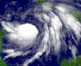
| Tropical Storm Wilma Hurricane Wilma Hurricane Wilma was the most intense tropical cyclone ever recorded in the Atlantic basin. Wilma was the twenty-second storm , thirteenth hurricane, sixth major hurricane, and fourth Category 5 hurricane of the record-breaking 2005 season... at T3.0 |
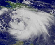
Tropical Storm Dennis Hurricane Dennis Hurricane Dennis was an early-forming major hurricane in the Caribbean and Gulf of Mexico during the very active 2005 Atlantic hurricane season. Dennis was the fourth named storm, second hurricane, and first major hurricane of the season... at T4.0 |
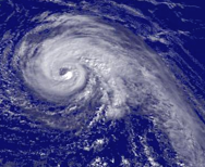
Hurricane Jeanne Hurricane Jeanne Hurricane Jeanne was the deadliest hurricane in the 2004 Atlantic hurricane season. It was the tenth named storm, the seventh hurricane, and the fifth major hurricane of the season, as well as the third hurricane and fourth named storm of the season to make landfall in Florida... at T5.0 |
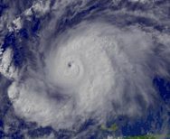
Hurricane Emily Hurricane Emily (2005) Hurricane Emily was a powerful, early season tropical cyclone that caused significant damage across the Caribbean Sea to Mexico. A Cape Verde-type hurricane, the storm formed on July 10, 2005, in the central Atlantic Ocean before passing through the Windward Islands on July 14... at T6.0 |
Variation
Friction between the atmosphere and the Earth's surface causes a 20% reduction in the wind at the surface of the Earth. Surface roughness also leads to significant variation of wind speeds. Over land, winds maximize at hill or mountain crests, while sheltering leads to lower wind speeds in valleys and lee slopes. Compared to over water, maximum sustained winds over land average 8% lower. More specifically, over a city or rough terrain, the wind gradient effect could cause a reduction of 40% to 50% of the geostrophic windGeostrophic wind
The geostrophic wind is the theoretical wind that would result from an exact balance between the Coriolis effect and the pressure gradient force. This condition is called geostrophic balance. The geostrophic wind is directed parallel to isobars . This balance seldom holds exactly in nature...
speed aloft; while over open water or ice, the reduction is between 10% and 30%.
Relationship to tropical cyclone strength scales
In most basins, maximum sustained winds are used to define their category. In the Atlantic and northeast Pacific oceans, the Saffir-Simpson scale is used. This scale can be used to determine possible storm surge and damage impact on land. In most basins, the category of the tropical cyclone (for example, tropical depression, tropical storm, hurricane/typhoon, super typhoon, depression, deep depression, intense tropical cyclone) is determined from the cycloneCyclone
In meteorology, a cyclone is an area of closed, circular fluid motion rotating in the same direction as the Earth. This is usually characterized by inward spiraling winds that rotate anticlockwise in the Northern Hemisphere and clockwise in the Southern Hemisphere of the Earth. Most large-scale...
's maximum sustained wind. Only in Australia
Australia
Australia , officially the Commonwealth of Australia, is a country in the Southern Hemisphere comprising the mainland of the Australian continent, the island of Tasmania, and numerous smaller islands in the Indian and Pacific Oceans. It is the world's sixth-largest country by total area...
is this quantity not used to define the tropical cyclone's category; in their basin, wind gusts are used.