

Timeline of the 2005 Atlantic hurricane season
Encyclopedia
Landfall (meteorology)
Landfall is the event of a tropical cyclone or a waterspout coming onto land after being over water. When a waterspout makes landfall it is reclassified as a tornado, which can then cause damage inland...
, extratropical transitions, and dissipations of the season's tropical and subtropical storms. The 2005 Atlantic hurricane season
2005 Atlantic hurricane season
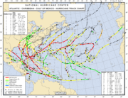
The 2005 Atlantic hurricane season was the most active Atlantic hurricane season in recorded history, repeatedly shattering numerous records. The impact of the season was widespread and ruinous with an estimated 3,913 deaths and record damage of about $159.2 billion...
was the most active Atlantic hurricane season
Atlantic hurricane season
The Atlantic hurricane season is the period in a year when hurricanes usually form in the Atlantic Ocean. Tropical cyclones in the North Atlantic are called hurricanes, tropical storms, or tropical depressions. In addition, there have been several storms over the years that have not been fully...
in recorded history. The season saw a record twenty-eight tropical or subtropical storms of which a record four storms achieved Category 5
Saffir-Simpson Hurricane Scale
The Saffir–Simpson Hurricane Scale , or the Saffir–Simpson Hurricane Wind Scale , classifies hurricanes — Western Hemisphere tropical cyclones that exceed the intensities of tropical depressions and tropical storms — into five categories distinguished by the intensities of their sustained winds...
status. Officially beginning on June 1 2005, and lasting until November 30, the 2005 season persisted into January 2006 due to continued storm activity.
The graphical bar below gives a brief overview of storm activity during the season. Each storm's maximum intensity is represented by the color of its bar. Tropical Storm Zeta
Tropical Storm Zeta (2005)
Tropical Storm Zeta was a late-developing tropical storm over the central Atlantic which formed after the 2005 Atlantic hurricane season had officially ended , and continued into January 2006...
persisted into 2006 necessitating the addition of January 2006 in both the graphical and text timelines. The timeline also makes use of information which was not operationally released. Every year, the National Hurricane Center
National Hurricane Center
The National Hurricane Center , located at Florida International University in Miami, Florida, is the division of the National Weather Service responsible for tracking and predicting weather systems within the tropics between the Prime Meridian and the 140th meridian west poleward to the 30th...
re-analyzes all of the systems of the previous hurricane season and revises their storm histories. New data that was not available while the storm was active is incorporated into these revisions. In this season the revisions were very significant, as an unnamed subtropical storm
2005 Azores subtropical storm
The 2005 Azores subtropical storm was the nineteenth nameable storm of the record-breaking 2005 Atlantic hurricane season. It was not officially named by the National Hurricane Center as it was operationally classified as a non-tropical low. The storm developed in the eastern Atlantic Ocean out of...
that went entirely unnoticed was discovered during the post-season review.
June
June 1- The 2005 Atlantic hurricane season officially begins.
June 8
- 2 p.m. EDT (1800 UTCCoordinated Universal TimeCoordinated Universal Time is the primary time standard by which the world regulates clocks and time. It is one of several closely related successors to Greenwich Mean Time. Computer servers, online services and other entities that rely on having a universally accepted time use UTC for that purpose...
) – Tropical Depression One forms just north of the north-eastern HondurasHondurasHonduras is a republic in Central America. It was previously known as Spanish Honduras to differentiate it from British Honduras, which became the modern-day state of Belize...
coast.
June 9
- 2 a.m. EDT (0600 UTC) – Tropical Depression One strengthens into Tropical Storm ArleneTropical Storm Arlene (2005)Tropical Storm Arlene was an unusually large and early-forming tropical storm forming during the 2005 Atlantic hurricane season. It was the first storm of the season, which would become the most active on record. Tropical Storm Arlene formed near Honduras on June 8 and moved northwards...
.
June 10
- 4 a.m. EDT (0800 UTC) – Tropical Storm Arlene makes its first landfall near Cabo CorrientesCabo CorrientesCabo Corrientes is a cape on the Pacific coast of the Mexican state of Jalisco. It marks the southernmost point of the Bahía de Banderas, upon which the port and resort city of Puerto Vallarta stands. The municipality in which the cape lies is also called Cabo Corrientes.Cabo Corrientes is a...
in western CubaCubaThe Republic of Cuba is an island nation in the Caribbean. The nation of Cuba consists of the main island of Cuba, the Isla de la Juventud, and several archipelagos. Havana is the largest city in Cuba and the country's capital. Santiago de Cuba is the second largest city...
with 50 mi/hThe figures for maximum sustained windMaximum sustained windThe maximum sustained winds associated with a tropical cyclone are a common indicator of the intensity of the storm. Within a mature tropical cyclone, they are found within the eyewall at a distance defined as the radius of maximum wind, or RMW. Unlike gusts, the value of these winds are...
s and position estimates are rounded to the nearest 5 units (knots, miles, or kilometersKilometreThe kilometre is a unit of length in the metric system, equal to one thousand metres and is therefore exactly equal to the distance travelled by light in free space in of a second...
), following the convention used in the National Hurricane CenterNational Hurricane CenterThe National Hurricane Center , located at Florida International University in Miami, Florida, is the division of the National Weather Service responsible for tracking and predicting weather systems within the tropics between the Prime Meridian and the 140th meridian west poleward to the 30th...
's operational products for each storm. All other units are rounded to the nearest digit. winds.
- 2 p.m. CDT (1900 UTC) – Tropical Storm Arlene makes its second landfall west of Pensacola, FloridaPensacola, FloridaPensacola is the westernmost city in the Florida Panhandle and the county seat of Escambia County, Florida, United States of America. As of the 2000 census, the city had a total population of 56,255 and as of 2009, the estimated population was 53,752...
with 60 mi/h winds. - 7 p.m. CDT (0000 UTC, June 12) – Tropical Storm Arlene weakens into a tropical depression.
June 13
- 5 p.m. EDT (2100 UTC) – The Hydrometeorological Prediction CenterHydrometeorological Prediction CenterThe Hydrometeorological Prediction Center is one of nine service centers under the umbrella of the National Centers for Environmental Prediction , a part of the National Weather Service, which in turn is part of the National Oceanic and Atmospheric Administration of the U.S. government...
(HPC) stops monitoring Tropical Depression Arlene over Michigan.
June 28
- 1 p.m. CDT (1800 UTC) – Tropical Depression Two forms about 60 miles (90 kmKilometreThe kilometre is a unit of length in the metric system, equal to one thousand metres and is therefore exactly equal to the distance travelled by light in free space in of a second...
) east-southeast of VeracruzVeracruzVeracruz, formally Veracruz de Ignacio de la Llave officially Estado Libre y Soberano de Veracruz de Ignacio de la Llave , is one of the 31 states that, along with the Federal District, comprise the 32 federative entities of Mexico. It is divided in 212 municipalities and its capital city is...
, MexicoMexicoThe United Mexican States , commonly known as Mexico , is a federal constitutional republic in North America. It is bordered on the north by the United States; on the south and west by the Pacific Ocean; on the southeast by Guatemala, Belize, and the Caribbean Sea; and on the east by the Gulf of...
. - 7 p.m. CDT (0000 UTC, June 29) – Tropical Depression Two strengthens into Tropical Storm BretTropical Storm Bret (2005)Tropical Storm Bret was a short-lived tropical storm of the 2005 Atlantic hurricane season that made landfall in the Mexican state of Veracruz, the first of four during the season. The second named storm of the season, Bret developed along a tropical wave on June 28 in the Bay of Campeche, and...
.
June 29
- 7 a.m. CDT (1200 UTC) – Tropical Storm Bret makes landfall near TuxpanTuxpanTuxpan is both a municipality and city located in the Mexican state of Veracruz. The population of the city was 78,523 and of the municipality was 134,394 inhabitants, according to the INEGI census of 2005, residing in a total area of 1,051.89 km²...
, Veracruz, Mexico with 40 mi/h winds. - 10 p.m. CDT (0300 UTC, June 30) – Tropical Depression Bret dissipates over Mexico.
July
July 3- 1 p.m. CDT (1800 UTC) – Tropical Depression Three forms in the northwestern Caribbean Sea, about 80 mi (130 km) east of ChetumalChetumalChetumal is a city on the east coast of the Yucatán Peninsula in Mexico. It is the capital of the state of Quintana Roo and the municipal seat of the Municipality of Othón P. Blanco...
, Quintana RooQuintana RooQuintana Roo officially Estado Libre y Soberano de Quintana Roo is one of the 31 states which, with the Federal District, comprise the 32 Federal Entities of Mexico. It is divided in 10 municipalities and its capital city is Chetumal....
, Mexico. - 10:30 p.m. CDT (0330 UTC, July 4) – Tropical Depression Three makes its first landfall on the YucatánYucatánYucatán officially Estado Libre y Soberano de Yucatán is one of the 31 states which, with the Federal District, comprise the 32 Federal Entities of Mexico. It is divided in 106 municipalities and its capital city is Mérida....
peninsula with 35 mi/h winds.
July 4
- 2 p.m. EDT (1800 UTC) – Tropical Depression Four forms in the southeastern Caribbean SeaCaribbean SeaThe Caribbean Sea is a sea of the Atlantic Ocean located in the tropics of the Western hemisphere. It is bounded by Mexico and Central America to the west and southwest, to the north by the Greater Antilles, and to the east by the Lesser Antilles....
. - 5 p.m. EDT (2100 UTC) – Tropical Depression Four makes its first landfall on GrenadaGrenadaGrenada is an island country and Commonwealth Realm consisting of the island of Grenada and six smaller islands at the southern end of the Grenadines in the southeastern Caribbean Sea...
with 30 mi/h winds.
July 5
- 1 a.m. CDT (0600 UTC) – Tropical Depression Three strengthens into Tropical Storm Cindy.
- 8 a.m. EDT (1200 UTC) – Tropical Depression Four strengthens into Tropical Storm Dennis.
- 8 p.m. EDT (0000 UTC, July 6) – Tropical Storm Cindy strengthens into Hurricane CindyHurricane Cindy (2005)Hurricane Cindy was a tropical cyclone that briefly reached minimal hurricane strength in the Gulf of Mexico during July in the 2005 Atlantic hurricane season and made landfall in Louisiana. It was the third named storm and first hurricane of the season...
. - 10 p.m. CDT (0300 UTC, July 6) – Hurricane Cindy makes its second landfall southwest of Grand Isle, LouisianaGrand Isle, LouisianaGrand Isle is a town in Jefferson Parish, Louisiana, located on a barrier island of the same name in the Gulf of Mexico. The island is at the mouth of Barataria Bay where it meets the gulf. As of the 2000 census, the town population was 1,541; during summers, the population sometimes increases to...
, United States with winds of 75 mi/h. - approximately 10:30 p.m. CDT (0330 UTC, July 6) – Hurricane Cindy weakens into a tropical storm.
- 5 a.m. CDT (0900 UTC) – Tropical Storm Cindy makes its third landfall near Waveland, MississippiWaveland, MississippiWaveland is a city located in Hancock County, Mississippi, on the Gulf of Mexico. It is part of the Gulfport–Biloxi, Mississippi Metropolitan Statistical Area. The City of Waveland was incorporated in 1972. As of the 2000 census, the city had a total population of 6,674...
with winds of 50 mi/h.
July 6
- 7 a.m. CDT (1200 UTC) – Tropical Storm Cindy weakens into a tropical depression.
- 5:27 p.m. EDT (2127 UTC) – Tropical Storm Dennis strengthens into Hurricane DennisHurricane DennisHurricane Dennis was an early-forming major hurricane in the Caribbean and Gulf of Mexico during the very active 2005 Atlantic hurricane season. Dennis was the fourth named storm, second hurricane, and first major hurricane of the season...
.
July 7
- 8 a.m. EDT (1200 UTC) – Hurricane Dennis reaches Category 2 intensity.
- 11 a.m. EDT (1500 UTC) – Tropical Depression Cindy becomes extratropical over the Carolinas.
- 2 p.m. EDT (1800 UTC) – Hurricane Dennis reaches Category 3 intensity.
- 8 p.m. EDT (0000 UTC, July 8) – Hurricane Dennis reaches Category 4 intensity.
- 10:45 p.m. EDT (0245 UTC, July 8) – Hurricane Dennis makes its second landfall in southeastern Cuba near Punta del Ingles with 140 mi/h winds.
July 8
- 2:45 p.m. EDT (1845 UTC) – Hurricane Dennis makes its third landfall along the south-central coast of Cuba with winds of 140 mi/h.
- 5 p.m. EDT (2100 UTC) – The HPC ceases advisories on the remnants of Tropical Depression Cindy.

- 2:30 p.m. CDT (1930 UTC) – Hurricane Dennis makes its fourth landfall just west of Navarre Beach, FloridaNavarre Beach, FloridaNavarre Beach, is an unincorporated community in Santa Rosa County in the U.S. state of Florida. It is on Santa Rosa Island, a barrier island in the Gulf of Mexico. The community is considered part of the Pensacola–Ferry Pass–Brent Metropolitan Statistical Area.Immediately to its east...
, United States with 120 mi/h winds. - 7 p.m. CDT (0000 UTC, July 11) – Hurricane Dennis weakens into a tropical storm.
- 8 p.m. ASTAtlantic Standard Time ZoneThe Atlantic Standard Time Zone is a geographical region that keeps time by subtracting four hours from either Coordinated Universal Time or Greenwich Mean Time , resulting in UTC-4 or GMT-4...
(0000 UTC, July 11) – Tropical Depression Five forms in the central Atlantic about 1,250 mi (2,000 km) east of the Southern Windward IslandsWindward IslandsThe Windward Islands are the southern islands of the Lesser Antilles, within the West Indies.-Name and geography:The Windward Islands are called such because they were more windward to sailing ships arriving in the New World than the Leeward Islands, given that the prevailing trade winds in the...
.
July 11
- 1 a.m. CDT (0600 UTC) – Tropical Storm Dennis weakens into a tropical depression.
- 8 p.m. AST (0000 UTC, July 12) – Tropical Depression Five strengthens into Tropical Storm Emily.
July 13
- 10 a.m. CDT (1500 UTC) – The HPC ceases advisories on the remnants of Tropical Depression Dennis.
- 8 p.m. AST (0000 UTC, July 13) – Tropical Storm Emily strengthens into Hurricane EmilyHurricane Emily (2005)Hurricane Emily was a powerful, early season tropical cyclone that caused significant damage across the Caribbean Sea to Mexico. A Cape Verde-type hurricane, the storm formed on July 10, 2005, in the central Atlantic Ocean before passing through the Windward Islands on July 14...
.
July 14
- 3 a.m. AST (0700 UTC) – Hurricane Emily makes its first landfall on Grenada with 90 mi/h winds.
- 8 a.m. AST (1200 UTC) – Hurricane Emily reaches Category 2 intensity.
- 2 p.m. AST (1800 UTC) – Hurricane Emily reaches Category 3 intensity.
July 15
- 2 a.m. AST (0600 UTC) – Hurricane Emily reaches Category 4 intensity.

- 8 p.m. EDT (0000 UTC, July 17) – Hurricane Emily reaches Category 5 intensity, the earliest that a hurricane has achieved this intensity in the Atlantic basin.
July 18
- 2:30 a.m. EDT (0630 UTC) – Hurricane Emily makes its second landfall near Tulum, Quintana Roo, Mexico with 130 mi/h winds.
July 20
- 6:35 a.m. CDT (1135 UTC) – Hurricane Emily makes its third landfall near Boca Madre, TamaulipasTamaulipasTamaulipas officially Estado Libre y Soberano de Tamaulipas is one of the 31 states which, with the Federal District, comprise the 32 Federal Entities of Mexico. It is divided in 43 municipalities and its capital city is Ciudad Victoria. The capital city was named after Guadalupe Victoria, the...
, Mexico with 125 mi/h winds.
July 21
- 1 p.m. CDT (1800 UTC) – Tropical Depression Emily dissipates over central Mexico.
- 1 p.m. EDT (1800 UTC) – Tropical Depression Six forms near the Bahamas.
- 8 p.m. EDT (0000 UTC, July 22) – Tropical Depression Six strengthens into Tropical Storm FranklinTropical Storm Franklin (2005)Tropical Storm Franklin was a tropical storm over the western Atlantic Ocean during July of the 2005 Atlantic hurricane season. It was the sixth named storm of the season and twice approached hurricane strength. The storm formed over the Bahamas on July 21 then moved north erratically, approaching...
.
July 23
- 3 p.m. CDT (1800 UTC) – Tropical Depression Seven forms in the Bay of CampecheBay of CampecheThe Bay of Campeche is the southern bight of the Gulf of Mexico. It is surrounded on three sides by the Mexican states of Campeche, Tabasco and Veracruz. It was named by Francisco Hernández de Córdoba and Antonio de Alaminos during their expedition in 1517...
.
July 24
- 1 a.m. CDT (0600 UTC) – Tropical Depression Seven becomes Tropical Storm GertTropical Storm Gert (2005)Tropical Storm Gert was the fourth of seven tropical cyclones to make landfall in Mexico during 2005...
. - 7 p.m. CDT (0000 UTC, July 25) – Tropical Storm Gert makes landfall near TampicoTampicoTampico is a city and port in the state of Tamaulipas, in the country of Mexico. It is located in the southeastern part of the state, directly north across the border from Veracruz. Tampico is the third largest city in Tamaulipas, and counts with a population of 309,003. The Metropolitan area of...
, Tamaulipas, Mexico with 45 mi/h winds.
July 25
- 8 p.m. CDT (0000 UTC, July 26) – Tropical Depression Gert dissipates over central Mexico.
July 29
- 8 p.m. EDT (0000 UTC, July 30) – Tropical Storm Franklin becomes extratropical east of Nova ScotiaNova ScotiaNova Scotia is one of Canada's three Maritime provinces and is the most populous province in Atlantic Canada. The name of the province is Latin for "New Scotland," but "Nova Scotia" is the recognized, English-language name of the province. The provincial capital is Halifax. Nova Scotia is the...
.
August
August 2- 2 p.m. AST (1800 UTC) – Tropical Depression Eight forms about 370 mi (590 km) southwest of BermudaBermudaBermuda is a British overseas territory in the North Atlantic Ocean. Located off the east coast of the United States, its nearest landmass is Cape Hatteras, North Carolina, about to the west-northwest. It is about south of Halifax, Nova Scotia, Canada, and northeast of Miami, Florida...
.
August 3
- 2 a.m. AST (0600 UTC) – Tropical Depression Eight strengthens into Tropical Storm HarveyTropical Storm Harvey (2005)Tropical Storm Harvey was a strong tropical storm over the western Atlantic Ocean in August during the 2005 Atlantic hurricane season. Harvey was the eighth named storm of the record-breaking season....
.
August 4
- 2 p.m. AST (1800 UTC) – Tropical Depression Nine forms about 690 mi (1,100 km) west of the Cape Verde Islands.
August 7
- 11 a.m. AST (1500 UTC) – Tropical Depression Nine strengthens into Tropical Storm Irene.
August 8
- 8 a.m. AST (1200 UTC) – Tropical Storm Irene weakens into a tropical depression.
- 8 p.m. AST (0000 UTC, August 10) – Tropical Storm Harvey becomes extratropical in northern Atlantic 560 mi (900 km) southeast of Newfoundland.
August 10
- 8 p.m. AST (0000 UTC, August 11) – Tropical Depression Irene regains tropical storm strength.
August 13
- 8 a.m. AST (1200 UTC) – Tropical Depression TenTropical Depression Ten (2005)Tropical Depression Ten was the tenth tropical cyclone of the record-breaking 2005 Atlantic hurricane season. It formed on August 13 from a tropical wave that emerged from the west coast of Africa on August 8. As a result of strong wind shear, the depression remained weak and did not strengthen...
forms about 1100 mi (1,800 km) east of the Lesser AntillesLesser AntillesThe Lesser Antilles are a long, partly volcanic island arc in the Western Hemisphere. Most of its islands form the eastern boundary of the Caribbean Sea with the Atlantic Ocean, with the remainder located in the southern Caribbean just north of South America...
.
August 14
- 11 a.m. AST (1500 UTC) – Tropical Depression Ten degenerates into a remnant low.
- 8 p.m. AST (0000 UTC, August 15) – Tropical Storm Irene strengthens into Hurricane IreneHurricane Irene (2005)Hurricane Irene was a long-lived Cape Verde-type Atlantic hurricane during the 2005 Atlantic hurricane season. The storm formed near Cape Verde on August 4 and crossed the Atlantic, turning northward around Bermuda before becoming extratropical southeast of Newfoundland. Irene persisted for...
.

- 8 a.m. AST (1200 UTC) – Hurricane Irene reaches Category 2 intensity.
August 18
- 2 p.m. AST (1800 UTC) – Tropical Storm Irene is absorbed by a larger extratropical system 290 mi (460 km) southeast of Newfoundland.
August 22
- 8 a.m. EDT (1200 UTC) – Tropical Depression Eleven forms in the Bay of Campeche.
- 2 p.m. EDT (1800 UTC) – Tropical Depression Eleven strengthens into Tropical Storm JoseTropical Storm Jose (2005)Tropical Storm Jose was a short-lived tropical storm which made landfall in central Mexico during August 2005. Jose was the tenth named storm of the 2005 Atlantic hurricane season and the fourth of six tropical cyclones to make landfall in Mexico in that year.Tropical Storm Jose formed in the Bay...
. - 10:30 p.m. CDT (0330 UTC, August 23) – Tropical Storm Jose makes landfall in Veracruz, Mexico with 60 mi/h winds.
August 23
- 1 p.m. CDT (1700 UTC) – Tropical Depression Jose dissipates.
- 2 p.m. EDT (1800 UTC) – Tropical Depression Twelve forms near Long Island, BahamasLong Island, BahamasLong Island is an island in the Bahamas that is split by the Tropic of Cancer. Its capital is Clarence Town. Long Island is one of the Districts of the Bahamas and is known as the most scenic island in the Bahamas. The population is roughly 4,000 inhabitants.-Geography:Long Island is about 130...
.
August 24
- 8 a.m. EDT (1200 UTC) – Tropical Depression Twelve strengthens into Tropical Storm Katrina.
August 25
- 5 p.m. EDT (2100 UTC) – Tropical Storm Katrina strengthens into Hurricane KatrinaHurricane KatrinaHurricane Katrina of the 2005 Atlantic hurricane season was a powerful Atlantic hurricane. It is the costliest natural disaster, as well as one of the five deadliest hurricanes, in the history of the United States. Among recorded Atlantic hurricanes, it was the sixth strongest overall...
. - 6:30 p.m. EDT (2230 UTC) – Hurricane Katrina makes its first landfall between Hallandale Beach and North Miami Beach, FloridaNorth Miami Beach, FloridaNorth Miami Beach is a Miami suburban city in Miami-Dade County, Florida, United States. Originally named Fulford in 1926 after Captain William H. Fulford of the United States Coast Guard, the city was incorporated in 1927 as Fulford, but was renamed North Miami Beach in 1931. The population was...
, United States with 80 mi/h winds.
August 26
- 1 a.m. EDT (0500 UTC) – Hurricane Katrina weakens into a tropical storm.
- 2 a.m. EDT (0600 UTC) – Tropical Storm Katrina again strengthens into Hurricane Katrina over the Gulf of MexicoGulf of MexicoThe Gulf of Mexico is a partially landlocked ocean basin largely surrounded by the North American continent and the island of Cuba. It is bounded on the northeast, north and northwest by the Gulf Coast of the United States, on the southwest and south by Mexico, and on the southeast by Cuba. In...
. - 2 p.m. EDT (1800 UTC) – Hurricane Katrina reaches Category 2 intensity.
August 27
- 8 a.m. EDT (1200 UTC) – Hurricane Katrina reaches Category 3 intensity.

- 1 a.m. CDT (0600 UTC) – Hurricane Katrina reaches Category 4 intensity.
- 7 a.m. CDT (1200 UTC) – Hurricane Katrina becomes the second Category 5 hurricane of the 2005 season.
- 8 a.m. AST (1200 UTC) – Tropical Depression Thirteen forms about 960 mi (1,550 km) east of the Lesser Antilles.
- 1 p.m. CDT (1800 UTC) – Hurricane Katrina's central pressure drops to 902 mbarBar (unit)The bar is a unit of pressure equal to 100 kilopascals, and roughly equal to the atmospheric pressure on Earth at sea level. Other units derived from the bar are the megabar , kilobar , decibar , centibar , and millibar...
(26.64 inHgInch of mercuryInches of mercury, ' is a unit of measurement for pressure. It is still widely used for barometric pressure in weather reports, refrigeration and aviation in the United States, but is seldom used elsewhere....
), making it the then fourth most intense Atlantic hurricane on record.
August 29
- 6:10 a.m. CDT (1110 UTC) – Hurricane Katrina makes its second landfall near Buras, Louisiana, United States with 110 knots winds, having just weakened from Category 4.
- 9:45 a.m. CDT (1445 UTC) – Hurricane Katrina makes its third landfall near Pearlington, MississippiPearlington, MississippiPearlington is a census-designated place in Hancock County, Mississippi, United States, on U.S. Route 90, along the Pearl River, at the Louisiana stateline. It is part of the Gulfport–Biloxi, Mississippi Metropolitan Statistical Area. The population was 1,684 at the 2000 census. On August...
, United States with 105 knots winds after crossing Breton SoundBreton SoundBreton Sound is a sound of the Gulf of Mexico and a part of the coastline of the U.S. state of Louisiana. It lies off the southeast coast of the state and is partially enclosed by the Breton Islands....
. - 2 p.m. AST (1800 UTC) – Tropical Depression Thirteen degenerates into a broad area of low pressure.
- 7 p.m. CDT (0000 UTC, August 30) – Hurricane Katrina weakens into a tropical storm.
August 30
- 7 a.m. CDT (1200 UTC) – Tropical Storm Katrina weakens into a tropical depression.
- 8 p.m. EDT (0000 UTC, August 31) – Tropical Depression Katrina becomes an extratropical low over KentuckyKentuckyThe Commonwealth of Kentucky is a state located in the East Central United States of America. As classified by the United States Census Bureau, Kentucky is a Southern state, more specifically in the East South Central region. Kentucky is one of four U.S. states constituted as a commonwealth...
.
August 31
- 2 a.m. AST (0600 UTC) – Tropical Depression Thirteen regenerates 890 mi (1,430 km) east-southeast of Bermuda.
- 8 a.m. AST (1200 UTC) – Tropical Depression Thirteen strengthens into Tropical Storm Lee.
- 8 p.m. AST (0000 UTC, September 1) – Tropical Storm Lee weakens into Tropical Depression Lee.
- 11 p.m. EDT (0300 UTC, September 1) – The HPC stops monitoring the remnants of Tropical Depression Katrina over southeastern CanadaCanadaCanada is a North American country consisting of ten provinces and three territories. Located in the northern part of the continent, it extends from the Atlantic Ocean in the east to the Pacific Ocean in the west, and northward into the Arctic Ocean...
.
September
September 1- 8 a.m. AST (1200 UTC) – Tropical Depression Fourteen forms 1,050 mi (1,700 km) east of the Leeward IslandsLeeward IslandsThe Leeward Islands are a group of islands in the West Indies. They are the northern islands of the Lesser Antilles chain. As a group they start east of Puerto Rico and reach southward to Dominica. They are situated where the northeastern Caribbean Sea meets the western Atlantic Ocean...
.
September 2
- 2 a.m. AST (0600 UTC) – Tropical Depression Lee degenerates into a remnant low over the central Atlantic.
- 8 a.m. AST (1200 UTC) – Tropical Depression Fourteen strengthens into Tropical Storm Maria.
September 4
- 5 a.m. AST (0900 UTC) – Tropical Storm Maria strengthens into Hurricane MariaHurricane Maria (2005)Hurricane Maria was a Cape Verde-type hurricane which formed in September during the 2005 Atlantic hurricane season. Maria was the thirteenth named storm, sixth hurricane, and fourth major hurricane of the record-breaking season....
.
September 5
- 8 a.m. AST (1200 UTC) – Hurricane Maria reaches Category 2 intensity.
- 2 p.m. AST (1800 UTC) – Tropical Depression Fifteen forms 350 mi (560 km) south-southwest of Bermuda.
- 8 p.m. AST (0000 UTC, September 6) – Hurricane Maria reaches Category 3 intensity.
- 8 p.m. EDT (0000 UTC, September 6) – Tropical Depression Fifteen strengthens into Tropical Storm Nate.
September 6
- 2 a.m. EDT (0600 UTC) – Tropical Depression Sixteen forms over the northern Bahamas.
- 12 p.m. EDT (1600 UTC) – Tropical Depression Sixteen makes landfall on Grand BahamaGrand BahamaGrand Bahama is one of the northernmost of the islands of the Bahamas, and the closest major island to the United States, lying off the state of Florida. Grand Bahama is the fifth largest island in the Bahamas island chain of approximately 700 islands and 2,400 cays...
with 30 mi/h winds.
September 7
- 2 a.m. EDT (0600 UTC) – Tropical Depression Sixteen strengthens into Tropical Storm Ophelia.
- 8 a.m. EDT (1200 UTC) – Tropical Storm Nate strengthens into Hurricane NateHurricane Nate (2005)Hurricane Nate was an Atlantic hurricane that threatened Bermuda but remained at sea during early September 2005. The fourteenth named storm and seventh hurricane of the 2005 season, Hurricane Nate formed to the southwest of Bermuda on September 5 and initially moved very slowly to the northeast...
.
September 8
- 8 p.m. EDT (0000 UTC, September 9) – Tropical Storm Ophelia strengthens into Hurricane OpheliaHurricane Ophelia (2005)Hurricane Ophelia was the fifteenth named tropical cyclone and the eighth hurricane of the 2005 Atlantic hurricane season. It was a long-lived storm that was most remembered for its very erratic and extremely slow track off the East Coast of the United States, alternating several times between...
. Ophelia oscillates between Hurricane and Tropical Storm strength several times over the next few days.
September 10
- 8 a.m. AST (1200 UTC) – Tropical Storm Maria becomes extratropical mid-way between Cape RaceCape RaceCape Race is a point of land located at the southeastern tip of the Avalon Peninsula on the island of Newfoundland, Canada. Its name is thought to come from the original Portuguese name for this cape, "Raso", or "bare"...
and the AzoresAzoresThe Archipelago of the Azores is composed of nine volcanic islands situated in the middle of the North Atlantic Ocean, and is located about west from Lisbon and about east from the east coast of North America. The islands, and their economic exclusion zone, form the Autonomous Region of the...
. - 2 p.m. EDT (1800 UTC) – Tropical Storm Nate becomes extratropical over the central Atlantic Ocean.

- 11 p.m. EDT (0300 UTC, September 15) – Hurricane Ophelia passes southeast of Cape Lookout, North Carolina with the storm's center staying just offshore.
September 15
- 8 p.m. EDT (0000 UTC, September 16) – Hurricane Ophelia weakens into a tropical storm for the last time.
September 17
- 8 a.m. EDT (1200 UTC) – Tropical Depression Seventeen forms 345 mi (560 km) east of BarbadosBarbadosBarbados is an island country in the Lesser Antilles. It is in length and as much as in width, amounting to . It is situated in the western area of the North Atlantic and 100 kilometres east of the Windward Islands and the Caribbean Sea; therein, it is about east of the islands of Saint...
. - 2 p.m. EDT (1800 UTC) – Tropical Depression Seventeen strengthens into Tropical Storm Philippe.
- 8 p.m. EDT (0000 UTC, September 18) – Tropical Storm Ophelia becomes extratropical off the coast of central Nova Scotia.
- 8 p.m. EDT (0000 UTC, September 18) – Tropical Depression Eighteen forms 80 mi (130 km) east of Grand Turk IslandGrand Turk IslandGrand Turk Island is an island in the Turks and Caicos Islands. It is the largest island in the Turks Islands with . It contains the territory's capital, Cockburn Town and the JAGS McCartney International Airport...
.
September 18
- 2 p.m. EDT (1800 UTC) – Tropical Depression Eighteen strengthens into Tropical Storm Rita.
- 8 p.m. EDT (0000 UTC, September 19) – Tropical Storm Philippe strengthens into Hurricane PhilippeHurricane Philippe (2005)Hurricane Philippe was a short-lived hurricane that formed over the Atlantic in September during the 2005 Atlantic hurricane season. Philippe was the sixteenth named storm and ninth hurricane of the season....
.
September 20
- 8 a.m. EDT (1200 UTC) – Tropical Storm Rita strengthens into Hurricane RitaHurricane RitaHurricane Rita was the fourth-most intense Atlantic hurricane ever recorded and the most intense tropical cyclone ever observed in the Gulf of Mexico. Rita caused $11.3 billion in damage on the U.S. Gulf Coast in September 2005...
. - 2 p.m. EDT (1800 UTC) – Hurricane Rita reaches Category 2 intensity.
- 8 a.m. EDT (1200 UTC) – Hurricane Philippe weakens into a tropical storm.
September 21
- 2 a.m. EDT (0600 UTC) – Hurricane Rita reaches Category 3 intensity.
- 8 a.m. EDT (1200 UTC) – Hurricane Rita reaches Category 4 intensity.
- 2 p.m. CDT (1800 UTC) – Hurricane Rita becomes the record-breaking third Category 5 hurricane of the season.
- 10 p.m. CDT (0300 UTC, September 22) – Hurricane Rita's central pressure drops to 895 mbar (26.43 inHg), making it the then third most intense Atlantic hurricane on record.
September 23
- 8 a.m. EDT (1200 UTC) – Tropical Storm Philippe weakens into a tropical depression.
- 2 p.m. EDT (1800 UTC) – Tropical Depression Philippe becomes a swirl of low clouds embedded within a broader non-tropical low.

- 2:40 a.m. CDT (0740 UTC) – Hurricane Rita makes landfall in LouisianaLouisianaLouisiana is a state located in the southern region of the United States of America. Its capital is Baton Rouge and largest city is New Orleans. Louisiana is the only state in the U.S. with political subdivisions termed parishes, which are local governments equivalent to counties...
just east of Sabine PassSabine PassSabine Pass is the natural outlet of Sabine Lake into the Gulf of Mexico. It borders Jefferson County, Texas, and Cameron Parish, Louisiana.Two major battles occurred here during the American Civil War, known as the First and Second Battles of Sabine Pass....
with 115 mi/h winds. - 1 p.m. CDT (1800 UTC) – Hurricane Rita weakens into a tropical storm.
September 25
- 1 a.m. CDT (0600 UTC) – Tropical Storm Rita weakens into a tropical depression.
September 26
- 4 a.m. CDT (0900 UTC) – The HPC stops monitoring Tropical Depression Rita while over the U.S. MidwestMidwestern United StatesThe Midwestern United States is one of the four U.S. geographic regions defined by the United States Census Bureau, providing an official definition of the American Midwest....
, the moisture having been absorbed by a cold front. This leads to the first lull period in the Atlantic since Tropical Depression Twelve formed on August 23rd.
September 30
- 8 a.m. EDT (1200 UTC) – Tropical Depression Nineteen forms 665 mi (1,065 km) west-southwest of the Cape VerdeCape VerdeThe Republic of Cape Verde is an island country, spanning an archipelago of 10 islands located in the central Atlantic Ocean, 570 kilometres off the coast of Western Africa...
Islands.
October
October 1- 7 a.m. CDT (1200 UTC) – Tropical Depression Twenty forms 130 mi (210 km) southeast of CozumelCozumelCozumel is an island in the Caribbean Sea off the eastern coast of Mexico's Yucatan Peninsula, opposite Playa del Carmen, and close to the Yucatan Channel. Cozumel is one of the ten municipalities of the state of Quintana Roo...
, Mexico.
October 2
- 1 a.m. CDT (0600 UTC) – Tropical Depression Twenty strengthens into Tropical Storm Stan.
- 5 a.m. CDT (1000 UTC) – Tropical Storm Stan makes its first landfall on the Yucatán PeninsulaYucatán PeninsulaThe Yucatán Peninsula, in southeastern Mexico, separates the Caribbean Sea from the Gulf of Mexico, with the northern coastline on the Yucatán Channel...
about 40 mi south of Tulum with 40 mi/h winds. - 3 p.m. AST (1800 UTC) – Tropical Depression Nineteen dissipates.
- 5 p.m. CDT (0000 UTC, October 3) – Tropical Storm Stan weakens into a tropical depression.
October 3
- 1 a.m. CDT (0600 UTC) – Tropical Depression Stan restrengthens into Tropical Storm Stan.
October 4
- 0600 UTC — A low pressure area in the open eastern Atlantic gains some tropical characteristics and becomes a subtropical depression. This depression is not assigned a number by the National Hurricane Center.
- 1 a.m. CDT (0600 UTC) – Tropical Storm Stan strengthens into Hurricane StanHurricane StanHurricane Stan was the eighteenth named tropical storm and eleventh hurricane of the 2005 Atlantic hurricane season. It was also the sixth of seven tropical cyclones to make landfall in Mexico. Stan was a relatively weak storm that only briefly reached hurricane status...
. - 1200 UTC — The subtropical depression in the eastern Atlantic becomes a subtropical storm2005 Azores subtropical stormThe 2005 Azores subtropical storm was the nineteenth nameable storm of the record-breaking 2005 Atlantic hurricane season. It was not officially named by the National Hurricane Center as it was operationally classified as a non-tropical low. The storm developed in the eastern Atlantic Ocean out of...
, but is not noticed, and thus not named. No advisories are issued on it by the National Hurricane Center. - 7 a.m. CDT (1200 UTC) – Hurricane Stan makes its second landfall about 90 mi (150 km) east-southeast of the Mexican port of VeracruzVeracruz, VeracruzVeracruz, officially known as Heroica Veracruz, is a major port city and municipality on the Gulf of Mexico in the Mexican state of Veracruz. The city is located in the central part of the state. It is located along Federal Highway 140 from the state capital Xalapa, and is the state's most...
with 80 mi/h winds. - 1 p.m. CDT (1800 UTC) – Hurricane Stan weakens into a tropical storm.
- 7 p.m. CDT (0000 UTC, October 5) – Tropical Storm Stan weakens into a tropical depression.
October 5
- 0600 UTC — The unnamed subtropical storm becomes extratropical over the northeastern Atlantic.
- 1 a.m. CDT (0600 UTC) – Tropical Depression Stan dissipates over southeastern Mexico.
- 2 a.m. EDT (0600 UTC) – Tropical Storm TammyTropical Storm Tammy (2005)Tropical Storm Tammy was a short lived tropical storm during October in the 2005 Atlantic hurricane season which caused minor damage to the southeastern United States. More significant, however were its remnants which contributed to the Northeast U.S. flooding of October 2005.Tropical Storm Tammy...
forms 25 mi (35 km) east of Jupiter, FloridaJupiter, FloridaJupiter is a town located in Palm Beach County, Florida. As of the 2000 census, the town had a total population of 39,328. The estimate population for 2009 is 50,606. As of 2006, the population had grown to 50,028, according to the University of Florida, Bureau of Economic and Business Research....
. - 7 p.m. EDT (2300 UTC) – Tropical Storm Tammy makes landfall near Atlantic Beach, FloridaAtlantic Beach, FloridaAtlantic Beach, a city in Duval County, Florida, is the northernmost of the Jacksonville Beaches communities. When the majority of communities in Duval County consolidated with Jacksonville, Florida in 1968, Atlantic Beach, along with Jacksonville Beach, Neptune Beach, and Baldwin, Florida,...
with 50 mi/h winds.
October 6
- 8 a.m. EDT (1200 UTC) – Tropical Storm Tammy weakens into a tropical depression.
- 5 p.m. EDT (2100 UTC) – The HPC stops monitoring Tropical Depression Tammy over western Florida.
October 8
- 2 a.m. EDT (0600 UTC) – Subtropical Depression Twenty-two forms 615 mi (1,000 km) south-east of Bermuda.
- 7 a.m. WESTWestern European TimeWestern European Time , defined legally as Greenwich Mean Time in the United Kingdom, is the time zone covering parts of western and northwestern Europe, and includes the following countries and regions:...
(0600 UTC) – Subtropical Storm Vince forms about 760 mi (930 km) southeast of the Azores, notably near the Iberian PeninsulaIberian PeninsulaThe Iberian Peninsula , sometimes called Iberia, is located in the extreme southwest of Europe and includes the modern-day sovereign states of Spain, Portugal and Andorra, as well as the British Overseas Territory of Gibraltar...
of Europe.
- 1 p.m. WEST (1200 UTC) – Subtropical Storm Vince gains tropical characteristics and becomes Tropical Storm Vince.
- 7 p.m. WEST (1800 UTC) – Tropical Storm Vince strengthens into Hurricane VinceHurricane Vince (2005)Hurricane Vince was an unusual hurricane that developed in the northeastern Atlantic basin. Forming in October during the 2005 Atlantic hurricane season, the waters over which it developed were considered too cold for tropical development...
.
October 10
- 2 a.m. EDT (0600 UTC) – Subtropical Depression Twenty-two degenerates into a remnant low.
- 2 a.m. CESTCentral European Summer TimeCentral European Summer Time is one of the names of the Daylight saving time offset using the UTC offset of UTC+02:00, 2 hours ahead of Coordinated Universal Time. It is used as a summer daylight saving time in most European countries. During the winter, Central European Time is used...
(0000 UTC) – Hurricane Vince weakens into a tropical storm.
October 11
- 2 a.m. CEST (0000 UTC) – Tropical Storm Vince weakens into a tropical depression.
- 11 a.m. CEST (0900 UTC) – Tropical Depression Vince makes landfall near HuelvaHuelvaHuelva is a city in southwestern Spain, the capital of the province of Huelva in the autonomous region of Andalusia. It is located along the Gulf of Cadiz coast, at the confluence of the Odiel and Tinto rivers. According to the 2010 census, the city has a population of 149,410 inhabitants. The...
, SpainSpainSpain , officially the Kingdom of Spain languages]] under the European Charter for Regional or Minority Languages. In each of these, Spain's official name is as follows:;;;;;;), is a country and member state of the European Union located in southwestern Europe on the Iberian Peninsula...
, with 35 mi/h winds, becoming the first tropical cyclone on record to make landfall in the country. - 2 p.m. CEST (1200 UTC) – Tropical Depression Vince dissipates over Spain.
October 15
- 2 p.m. EDT (1800 UTC) – Tropical Depression Twenty-four forms 220 mi (350 km) east-southeast of Grand CaymanGrand CaymanGrand Cayman is the largest of the three Cayman Islands and the location of the nation's capital, George Town. In relation to the other two Cayman Islands, it is approximately 75 miles southwest of Little Cayman and 90 miles southwest of Cayman Brac.-Geography:Grand Cayman encompasses 76% of...
.
October 17
- 2 a.m. EDT (0600 UTC) – Tropical Depression Twenty-four strengthens into Tropical Storm Wilma.
October 18
- 8 a.m. EDT (1200 UTC) – Tropical Storm Wilma strengthens into Hurricane WilmaHurricane WilmaHurricane Wilma was the most intense tropical cyclone ever recorded in the Atlantic basin. Wilma was the twenty-second storm , thirteenth hurricane, sixth major hurricane, and fourth Category 5 hurricane of the record-breaking 2005 season...
. - 3 p.m. EDT (1900 UTC) – Hurricane Wilma reaches Category 2 intensity (time estimated).
- 5 p.m. EDT (2100 UTC) – Hurricane Wilma reaches Category 3 intensity (time estimated).
- 8 p.m. EDT (0000 UTC, October 19) – Hurricane Wilma reaches Category 4 intensity.

- 2 a.m. EDT (0600 UTC) – Hurricane Wilma becomes the fourth Category 5 hurricane of the season.
- 4 a.m. EDT (0800 UTC) – Hurricane Wilma's central pressure is recorded at 884 mbar (26.11 inHg), making it the most intense hurricane ever recorded in the Atlantic basin.
- 8 a.m. EDT (1200 UTC) – Hurricane Wilma's central pressure drops again to 882 mbar (26.05 inHg), confirming it as the most intense hurricane ever recorded in the Atlantic basin.
October 21
- 4:45 p.m. CDT (2145 UTC) – Hurricane Wilma makes its first landfall over the Mexican island of Cozumel with 150 mi/h winds.
- 10:30 p.m. CDT (0330 UTC, October 22) – Hurricane Wilma makes its second landfall at Puerto MorelosPuerto MorelosPuerto Morelos is a town and sea port in Quintana Roo, Mexico's easternmost state, on the Yucatán Peninsula. The town is at the southern end of the municipality of Benito Juárez in the northeast of the state, about 36 km south of the resort city of Cancún...
, Quintana Roo, near CancúnCancúnCancún is a city of international tourism development certified by the UNWTO . Located on the northeast coast of Quintana Roo in southern Mexico, more than 1,700 km from Mexico City, the Project began operations in 1974 as Integrally Planned Center, a pioneer of FONATUR Cancún is a city of...
, with 140 mi/h winds.
October 22
- 8 a.m. EDT (1200 UTC) – Tropical Depression Twenty-five forms in the eastern Caribbean Sea.
- 2 p.m. EDT (1800 UTC) – Tropical Depression Twenty-five strengthens into Tropical Storm AlphaTropical Storm Alpha (2005)Tropical Storm Alpha was the twenty-third named storm of the 2005 Atlantic hurricane season. The twenty-one names from the predetermined A–W list having been used, Alpha was the first tropical storm ever to be given a name from the Greek alphabet. On October 20, Tropical Depression...
.
October 23
- 6 a.m. EDT (1000 UTC) – Tropical Storm Alpha makes landfall near Barahona, Dominican RepublicDominican RepublicThe Dominican Republic is a nation on the island of La Hispaniola, part of the Greater Antilles archipelago in the Caribbean region. The western third of the island is occupied by the nation of Haiti, making Hispaniola one of two Caribbean islands that are shared by two countries...
with 50 mi/h winds. - 2 p.m. EDT (1800 UTC) – Tropical Storm Alpha weakens into a tropical depression.
October 24
- 2 a.m. EDT (0600 UTC) – Hurricane Wilma restrengthens to Category 3 intensity.
- 6:30 a.m. EDT (1030 UTC) – Hurricane Wilma makes its third landfall near Goodland, FloridaGoodland, FloridaGoodland is a census-designated place in Collier County, Florida, United States. The population was 320 at the 2000 census. It is part of the Naples–Marco Island Metropolitan Statistical Area...
, with 120 mi/h winds. - 8 p.m. EDT (0000 UTC), October 25) – Tropical Depression Alpha degenerates into a trough connected to Hurricane Wilma.
October 25
- 8 p.m. EDT (0000 UTC, October 26) – Hurricane Wilma becomes extratropical over the Atlantic Ocean.
October 26
- 2 p.m. EDT (1800 UTC) – Tropical Depression Twenty-six forms in the southwestern Caribbean Sea, just off Central America.
October 27
- 2 a.m. EDT (0600 UTC) – Tropical Depression Twenty-six strengthens into Tropical Storm Beta.
October 28
- 8 p.m. EDT (0000 UTC, October 29) – Tropical Storm Beta passes near the island of Providencia.

- 2 a.m. EDT (0600 UTC) – Tropical Storm Beta strengthens into Hurricane BetaHurricane Beta (2005)Hurricane Beta was a compact and intense tropical cyclone that impacted areas around the southwestern Caribbean Sea in late October 2005. Beta was the twenty-fourth tropical or subtropical storm, fourteenth hurricane, and seventh and final major hurricane of the record-breaking 2005 Atlantic...
. - 8 p.m. EDT (0000 UTC, October 30) – Hurricane Beta reaches Category 2 intensity.
October 30
- 1 a.m. EST (0600 UTC) – Hurricane Beta reaches Category 3 intensity.
- 7 a.m. EST (1200 UTC) – Hurricane Beta makes landfall near La Barra in Región Autónoma del Atlántico SurRegión Autónoma del Atlántico SurRegión Autónoma del Atlántico Sur , sometimes shortened to RAAS, is one of two autonomous regions in Nicaragua. It covers an area of 27,407 km² and has a population of 382,100...
, NicaraguaNicaraguaNicaragua is the largest country in the Central American American isthmus, bordered by Honduras to the north and Costa Rica to the south. The country is situated between 11 and 14 degrees north of the Equator in the Northern Hemisphere, which places it entirely within the tropics. The Pacific Ocean...
, with 105 mi/h winds. - 1 p.m. EST (1800 UTC) – Hurricane Beta weakens into a tropical storm.
- 7 p.m. EST (0000 UTC, October 31) – Tropical Storm Beta weakens into a tropical depression, and advisories are discontinued.
November
November 13- 7 p.m. EST (0000 UTC, November 14) – Tropical Depression Twenty-seven forms 100 mi (160 km) west of St. VincentSaint Vincent (island)Saint Vincent is a volcanic island in the Caribbean. It is the largest island of the chain called Saint Vincent and the Grenadines. It is located in the Caribbean Sea, between Saint Lucia and Grenada. It is composed of partially submerged volcanic mountains...
.
November 15
- 1 a.m. EST (0600 UTC) – Tropical Depression Twenty-seven strengthens into Tropical Storm Twenty-seven, although the NHC forecasters do not notice it at the time.
November 16
- 10 a.m. EST (1500 UTC) – Tropical Storm Twenty-seven weakens to Tropical Depression Twenty-seven and loses its closed circulation south of Kingston, JamaicaKingston, JamaicaKingston is the capital and largest city of Jamaica, located on the southeastern coast of the island. It faces a natural harbour protected by the Palisadoes, a long sand spit which connects the town of Port Royal and the Norman Manley International Airport to the rest of the island...
, and advisories are discontinued.
November 18
- 12 p.m. CST (1800 UTC) – Tropical Depression Twenty-seven regenerates in the Western Caribbean and strengthens into Tropical Storm GammaTropical Storm Gamma (2005)Tropical Storm Gamma was the 24th tropical storm of the 2005 Atlantic hurricane season. It was the first tropical cyclone to make landfall in Honduras since Hurricane Mitch of 1998. Gamma formed on November 18 from a tropical wave which had left the coast of Africa on November 3...
.
November 20
- 12 a.m. EST (0600 UTC, November 21) – Tropical Depression Gamma degenerates into a remnant low north of Honduras and advisories are discontinued.
November 22
- 2 p.m. AST (1800 UTC) – Subtropical Storm Delta forms 870 mi (1,400 km) southwest of the Azores from a previously non-tropical low.
- 8 a.m. AST (1200 UTC) – Subtropical Storm Delta gains tropical characteristics and becomes Tropical Storm DeltaTropical Storm Delta (2005)TropicalStorm Delta was a late-forming tropical storm of the 2005 Atlantic hurricane season which struck the Canary Islands as a strong extratropical storm, causing significant damage and then crossed over Morocco before dissipating...
.
November 28
- 8 a.m. AST (1200 UTC) – Tropical Storm Delta becomes extratropical about 250 mi (400 km) west-northwest of the Canary IslandsCanary IslandsThe Canary Islands , also known as the Canaries , is a Spanish archipelago located just off the northwest coast of mainland Africa, 100 km west of the border between Morocco and the Western Sahara. The Canaries are a Spanish autonomous community and an outermost region of the European Union...
.
November 29
- 2 a.m. AST (0600 UTC) – Tropical Storm Epsilon forms east of Bermuda from a previously non-tropical low.
November 30
- The 2005 Atlantic hurricane season officially comes to an end, though Tropical Storm Epsilon still remains active.

December
December 2- 2 p.m. AST (1800 UTC) – Tropical Storm Epsilon strengthens into Hurricane Epsilon.
December 7
- 2 p.m. AST (1800 UTC) – Hurricane Epsilon weakens into a tropical storm.
December 8
- 12 a.m. AST (1200 UTC) – Tropical Storm Epsilon weakens into a tropical depression and loses its convection.
December 29
- 8 p.m. AST (0000 UTC, December 30) – Tropical Depression Thirty forms over the eastern Atlantic.
December 30
- 2 a.m. AST (0600 UTC) – Tropical Depression Thirty strengthens into Tropical Storm ZetaTropical Storm Zeta (2005)Tropical Storm Zeta was a late-developing tropical storm over the central Atlantic which formed after the 2005 Atlantic hurricane season had officially ended , and continued into January 2006...
, the second latest tropical cyclone forming in the Atlantic (after Hurricane Alice in 1954).
January
January 1- The year 2006 begins with Tropical Storm Zeta still active, making Zeta only the second cross-season North Atlantic tropical cyclone ever recorded.
January 6
- 2 a.m. AST (0600 UTC) – Tropical Storm Zeta weakens into a tropical depression.
- 5 p.m. AST (2100 UTC) – Tropical Depression Zeta dissipates, finally ending the 2005 Atlantic hurricane season.
See also
- 2005 Atlantic hurricane season2005 Atlantic hurricane seasonThe 2005 Atlantic hurricane season was the most active Atlantic hurricane season in recorded history, repeatedly shattering numerous records. The impact of the season was widespread and ruinous with an estimated 3,913 deaths and record damage of about $159.2 billion...
- List of 2005 Atlantic hurricane season storms
- 2005 Atlantic hurricane season statistics2005 Atlantic hurricane season statisticsThe 2005 Atlantic hurricane season broke numerous records for cyclonic formation and intensity. It saw a total of thirty-one tropical and subtropical cyclones form, many of which broke records as individual storm as well as contributing to a number of season records...
- Timeline of Hurricane KatrinaTimeline of Hurricane KatrinaThis article contains a historical timeline of the events of Hurricane Katrina.-Tuesday, August 23, 2005:Tropical Depression Twelve formed over the southeastern Bahamas at 5:00 p.m. EDT on August 23, 2005, partially from the remains of Tropical Depression Ten, which had dissipated due to the...
- List of Atlantic hurricane seasons
- Timeline of the 2005 Pacific hurricane seasonTimeline of the 2005 Pacific hurricane seasonThe 2005 Pacific hurricane season was the least active season since the 2001 season, producing 16 tropical depressions; 15 of which became tropical storms or hurricanes...
- Timeline of the 2005 Pacific typhoon seasonTimeline of the 2005 Pacific typhoon seasonThe 2005 Pacific typhoon season has no official bounds; it runs year-round in 2005, but most tropical cyclones tend to form in the northwestern Pacific Ocean between June and December...