
.gif)
Hurricane Vince (2005)
Encyclopedia
Hurricane Vince was an unusual hurricane that developed in the northeastern Atlantic basin
. Forming in October during the 2005 Atlantic hurricane season
, the waters over which it developed were considered too cold for tropical development. Vince was the twentieth named tropical cyclone and twelfth hurricane of the extremely active season.
Vince developed from an extratropical system
on October 8, becoming a subtropical storm southeast of the Azores
. The National Hurricane Center
(NHC) did not officially name the storm until the next day, shortly before Vince became a hurricane. The storm weakened at sea and, on October 11, made landfall on the Iberian Peninsula
as a tropical depression. Vince was the first tropical system to do so since the 1842 Spain hurricane. It dissipated over Spain, bringing much needed rain to the region, and its remnants passed into the Mediterranean Sea
.
which had gone unnoticed by the NHC was absorbed by a temperate frontal low
, which was moving to the southeast over the Azores. The low pressure system gained a more concentrated circulation and lost its frontal structure
after absorbing the subtropical storm. The developing system became a subtropical storm itself early on October 8, 580 miles (930 km) southeast of Lajes
in the Azores. However, the NHC decided not to name the system Vince at the time, because the water temperature
was too low for normal development for a tropical cyclone
. The storm gradually gained the tropical characteristics of symmetry and a warm inner core and became a tropical storm the next day. Its transformation to a tropical system occurred over water cooler than 24 °C (75 °F), much colder than the 26.5 °C (80 °F) usually required for tropical development.
Soon after it became a tropical storm on October 9 near Madeira
, with a ragged eye
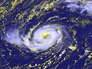
already present, the NHC officially named it Tropical Storm Vince and began to issue advisories. At the time there was some uncertainty as to whether Vince was tropical or subtropical but, in his post-season analysis, forecaster James L. Franklin of the NHC conceded that Vince had formed as a subtropical storm and had evolved into a tropical storm before it was named. The storm's ragged eye quickly solidified and contracted into a "bona fide" eye with a diameter of 15 mi (25 km). This increase in organization was accompanied by strengthening, and Vince reached its peak strength as a hurricane with 75 mph (120 km/h) winds later that day. The NHC forecaster decided that "if it looks like a hurricane, it probably is, despite its environment and unusual location".
 Hurricane Vince's impressive organization was very short lived as westerly wind shear
began to erode the eye within hours. In response, the storm weakened to a tropical storm shortly thereafter. A broad low-level trough
approached the storm from the northwest, pulling the convection
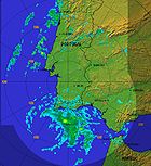
northward as the storm's low-level center accelerated eastward. On October 10, two brief bursts of convection surprised forecasters, but with the sea surface temperature as low as 22 °C (72 °F), the flares were not sustained. Vince continued to weaken as it approached the Iberian Peninsula and became a tropical depression on October 11, shortly before it made landfall near Huelva
, Spain. The fast-moving tropical depression quickly dissipated over land. Its remnants moved across southern Spain, dumping rain on the drought-ridden region, and moved into the Mediterranean Sea south of Alicante
in the early hours of October 12.
 The Spanish Center for Emergency Coordination declared a rain pre-emergency for the province of Castellón
in the anticipation that Hurricane Vince would bring rains capable of flooding. The Instituto Nacional de Meteorología (INM) issued a bulletin that warned of a 40% chance of flooding. Four autonomous regions
(Asturias
, Cataluña
, Castile and León
, and Galicia) issued flood warnings, and Canarias
issued a wind warning. Spanish fishing fleets off the Andalusia
n coast returned to port and weathered the storm on their moorings rather than in the open ocean.
Spain's population, which had been battling fires after a record breaking summer drought, welcomed the rains brought by Vince's remnants. In two days the storm brought more rain to the province of A Coruña
than had fallen all summer, easing the sinking water levels in provincial reservoirs, but also causing traffic jams and minor floods. In Cordoba province, the A-303, A-306 and OC-293 roads were partially flooded but "passable with caution". Municipal roadworks on la Ronda de Poniente, a major traffic artery connecting the city to nearby highways, were flooded and partially destroyed. The entrance of the University of A Coruña
was temporarily blocked by flood waters on October 11, and a nearby roundabout was submerged. These damages were minor, and no fatalities were reported. The highest winds reported on land were 48 mph (77 km/h) at Jerez, Spain, although some ships recorded stronger. Vince was comparable to normal rain events from temperate systems, with only 1 to 2 inches (25 to 50 mm) of rain falling. Through a play on words of a song
in the musical My Fair Lady
, National Hurricane Center forecaster James Franklin
in the Tropical Cyclone Report for Vince wrote, "the rain in Spain was mainly less than 2 inches, although 3.30 inches (84 mm) fell in the plain at Cordoba."
 Although Hurricane Vince developed in an unusual location in the northeastern Atlantic, well away from where tropical cyclones are usually found, it is neither the most northerly-forming nor the most easterly-forming Atlantic tropical storm; these records are held by Alberto
of the 1988 season
at 41.5° N, and Ginger of the 1967 season
at 18.1° W, respectively.
Hurricane Vince developed into a hurricane farther east than any known storm, at 18.9° W. The National Hurricane Center declared that Vince was the first tropical cyclone on record to have made landfall on the Iberian Peninsula. Historical documents, however, suggest that a possibly stronger tropical storm, the 1842 Spain hurricane, struck the Iberian Peninsula on October 29, 1842. Vince's record north was broken by Tropical Storm Grace (2009)
.
When Subtropical Storm Vince formed on October 8, it was the earliest in the season that the twenty-first tropical or subtropical storm had ever developed, 38 days ahead of the previous record held by Tropical Storm Twenty-one of the 1933 season
. Hurricane Vince was also the first named "V" storm in the Atlantic since naming began in 1950. Because the storm did not cause significant damage, the name Vince was not retired by the World Meteorological Organization
and will be on the list of names for the 2011 season.
The NHC's archive on Hurricane Vince
The NHC's Tropical Cyclone Report on Hurricane Vince (PDF) Especial -> Huracán Vince: seguimiento, fotos, datos, opiniones sobre origen
Atlantic Basin
The Atlantic Basin is the Atlantic Ocean.Atlantic Basin may also refer to:* Atlantic Basin Iron Works, an ironworks that operated in Brooklyn, New York, in the early to mid-20th century...
. Forming in October during the 2005 Atlantic hurricane season
2005 Atlantic hurricane season
The 2005 Atlantic hurricane season was the most active Atlantic hurricane season in recorded history, repeatedly shattering numerous records. The impact of the season was widespread and ruinous with an estimated 3,913 deaths and record damage of about $159.2 billion...
, the waters over which it developed were considered too cold for tropical development. Vince was the twentieth named tropical cyclone and twelfth hurricane of the extremely active season.
Vince developed from an extratropical system
Extratropical cyclone
Extratropical cyclones, sometimes called mid-latitude cyclones or wave cyclones, are a group of cyclones defined as synoptic scale low pressure weather systems that occur in the middle latitudes of the Earth having neither tropical nor polar characteristics, and are connected with fronts and...
on October 8, becoming a subtropical storm southeast of the Azores
Azores
The Archipelago of the Azores is composed of nine volcanic islands situated in the middle of the North Atlantic Ocean, and is located about west from Lisbon and about east from the east coast of North America. The islands, and their economic exclusion zone, form the Autonomous Region of the...
. The National Hurricane Center
National Hurricane Center
The National Hurricane Center , located at Florida International University in Miami, Florida, is the division of the National Weather Service responsible for tracking and predicting weather systems within the tropics between the Prime Meridian and the 140th meridian west poleward to the 30th...
(NHC) did not officially name the storm until the next day, shortly before Vince became a hurricane. The storm weakened at sea and, on October 11, made landfall on the Iberian Peninsula
Iberian Peninsula
The Iberian Peninsula , sometimes called Iberia, is located in the extreme southwest of Europe and includes the modern-day sovereign states of Spain, Portugal and Andorra, as well as the British Overseas Territory of Gibraltar...
as a tropical depression. Vince was the first tropical system to do so since the 1842 Spain hurricane. It dissipated over Spain, bringing much needed rain to the region, and its remnants passed into the Mediterranean Sea
Mediterranean Sea
The Mediterranean Sea is a sea connected to the Atlantic Ocean surrounded by the Mediterranean region and almost completely enclosed by land: on the north by Anatolia and Europe, on the south by North Africa, and on the east by the Levant...
.
Meteorological history
On October 5, an operationally unnamed subtropical storm2005 Azores subtropical storm
The 2005 Azores subtropical storm was the nineteenth nameable storm of the record-breaking 2005 Atlantic hurricane season. It was not officially named by the National Hurricane Center as it was operationally classified as a non-tropical low. The storm developed in the eastern Atlantic Ocean out of...
which had gone unnoticed by the NHC was absorbed by a temperate frontal low
Low pressure area
A low-pressure area, or "low", is a region where the atmospheric pressure at sea level is below that of surrounding locations. Low-pressure systems form under areas of wind divergence which occur in upper levels of the troposphere. The formation process of a low-pressure area is known as...
, which was moving to the southeast over the Azores. The low pressure system gained a more concentrated circulation and lost its frontal structure
Weather front
A weather front is a boundary separating two masses of air of different densities, and is the principal cause of meteorological phenomena. In surface weather analyses, fronts are depicted using various colored lines and symbols, depending on the type of front...
after absorbing the subtropical storm. The developing system became a subtropical storm itself early on October 8, 580 miles (930 km) southeast of Lajes
Lajes
Lajes is Portuguese for "covering of flat rock", or "flagstone", and may refer to:=*Lajes, Rio Grande do Norte*Lages, Santa Catarina , Brazil*Lajes Pintadas, Rio Grande do Norte- Archipelago of the Azores :...
in the Azores. However, the NHC decided not to name the system Vince at the time, because the water temperature
Sea surface temperature
Sea surface temperature is the water temperature close to the oceans surface. The exact meaning of surface varies according to the measurement method used, but it is between and below the sea surface. Air masses in the Earth's atmosphere are highly modified by sea surface temperatures within a...
was too low for normal development for a tropical cyclone
Tropical cyclone
A tropical cyclone is a storm system characterized by a large low-pressure center and numerous thunderstorms that produce strong winds and heavy rain. Tropical cyclones strengthen when water evaporated from the ocean is released as the saturated air rises, resulting in condensation of water vapor...
. The storm gradually gained the tropical characteristics of symmetry and a warm inner core and became a tropical storm the next day. Its transformation to a tropical system occurred over water cooler than 24 °C (75 °F), much colder than the 26.5 °C (80 °F) usually required for tropical development.
Soon after it became a tropical storm on October 9 near Madeira
Madeira
Madeira is a Portuguese archipelago that lies between and , just under 400 km north of Tenerife, Canary Islands, in the north Atlantic Ocean and an outermost region of the European Union...
, with a ragged eye
Eye (cyclone)
The eye is a region of mostly calm weather found at the center of strong tropical cyclones. The eye of a storm is a roughly circular area and typically 30–65 km in diameter. It is surrounded by the eyewall, a ring of towering thunderstorms where the second most severe weather of a cyclone...
already present, the NHC officially named it Tropical Storm Vince and began to issue advisories. At the time there was some uncertainty as to whether Vince was tropical or subtropical but, in his post-season analysis, forecaster James L. Franklin of the NHC conceded that Vince had formed as a subtropical storm and had evolved into a tropical storm before it was named. The storm's ragged eye quickly solidified and contracted into a "bona fide" eye with a diameter of 15 mi (25 km). This increase in organization was accompanied by strengthening, and Vince reached its peak strength as a hurricane with 75 mph (120 km/h) winds later that day. The NHC forecaster decided that "if it looks like a hurricane, it probably is, despite its environment and unusual location".
Wind shear
Wind shear, sometimes referred to as windshear or wind gradient, is a difference in wind speed and direction over a relatively short distance in the atmosphere...
began to erode the eye within hours. In response, the storm weakened to a tropical storm shortly thereafter. A broad low-level trough
Trough (meteorology)
A trough is an elongated region of relatively low atmospheric pressure, often associated with fronts.Unlike fronts, there is not a universal symbol for a trough on a weather chart. The weather charts in some countries or regions mark troughs by a line. In the United States, a trough may be marked...
approached the storm from the northwest, pulling the convection
Atmospheric convection
Atmospheric convection is the result of a parcel-environment instability, or temperature difference, layer in the atmosphere. Different lapse rates within dry and moist air lead to instability. Mixing of air during the day which expands the height of the planetary boundary layer leads to...
northward as the storm's low-level center accelerated eastward. On October 10, two brief bursts of convection surprised forecasters, but with the sea surface temperature as low as 22 °C (72 °F), the flares were not sustained. Vince continued to weaken as it approached the Iberian Peninsula and became a tropical depression on October 11, shortly before it made landfall near Huelva
Huelva
Huelva is a city in southwestern Spain, the capital of the province of Huelva in the autonomous region of Andalusia. It is located along the Gulf of Cadiz coast, at the confluence of the Odiel and Tinto rivers. According to the 2010 census, the city has a population of 149,410 inhabitants. The...
, Spain. The fast-moving tropical depression quickly dissipated over land. Its remnants moved across southern Spain, dumping rain on the drought-ridden region, and moved into the Mediterranean Sea south of Alicante
Alicante
Alicante or Alacant is a city in Spain, the capital of the province of Alicante and of the comarca of Alacantí, in the south of the Valencian Community. It is also a historic Mediterranean port. The population of the city of Alicante proper was 334,418, estimated , ranking as the second-largest...
in the early hours of October 12.
Preparations and impact
Castellón (province)
Castellón or Castelló is a province in the northern part of the Valencian Community, Spain. It is bordered by the provinces of Valencia to the south, Teruel to the west, Tarragona to the north, and by the Mediterranean Sea to the east. The western side of the province is in the mountainous...
in the anticipation that Hurricane Vince would bring rains capable of flooding. The Instituto Nacional de Meteorología (INM) issued a bulletin that warned of a 40% chance of flooding. Four autonomous regions
Autonomous communities of Spain
An autonomous community In other languages of Spain:*Catalan/Valencian .*Galician .*Basque . The second article of the constitution recognizes the rights of "nationalities and regions" to self-government and declares the "indissoluble unity of the Spanish nation".Political power in Spain is...
(Asturias
Asturias
The Principality of Asturias is an autonomous community of the Kingdom of Spain, coextensive with the former Kingdom of Asturias in the Middle Ages...
, Cataluña
Catalonia
Catalonia is an autonomous community in northeastern Spain, with the official status of a "nationality" of Spain. Catalonia comprises four provinces: Barcelona, Girona, Lleida, and Tarragona. Its capital and largest city is Barcelona. Catalonia covers an area of 32,114 km² and has an...
, Castile and León
Castile and León
Castile and León is an autonomous community in north-western Spain. It was so constituted in 1983 and it comprises the historical regions of León and Old Castile...
, and Galicia) issued flood warnings, and Canarias
Canary Islands
The Canary Islands , also known as the Canaries , is a Spanish archipelago located just off the northwest coast of mainland Africa, 100 km west of the border between Morocco and the Western Sahara. The Canaries are a Spanish autonomous community and an outermost region of the European Union...
issued a wind warning. Spanish fishing fleets off the Andalusia
Andalusia
Andalusia is the most populous and the second largest in area of the autonomous communities of Spain. The Andalusian autonomous community is officially recognised as a nationality of Spain. The territory is divided into eight provinces: Huelva, Seville, Cádiz, Córdoba, Málaga, Jaén, Granada and...
n coast returned to port and weathered the storm on their moorings rather than in the open ocean.
Spain's population, which had been battling fires after a record breaking summer drought, welcomed the rains brought by Vince's remnants. In two days the storm brought more rain to the province of A Coruña
A Coruña (province)
The province of A Coruña is the most North-western Atlantic-facing province of Spain, and one of the four provinces which constitute the autonomous community of Galicia...
than had fallen all summer, easing the sinking water levels in provincial reservoirs, but also causing traffic jams and minor floods. In Cordoba province, the A-303, A-306 and OC-293 roads were partially flooded but "passable with caution". Municipal roadworks on la Ronda de Poniente, a major traffic artery connecting the city to nearby highways, were flooded and partially destroyed. The entrance of the University of A Coruña
University of A Coruña
The University of A Coruña is a public university located in the city of A Coruña, Galicia. Established in 1989, university departments are divided between two primary campuses in A Coruña and nearby Ferrol...
was temporarily blocked by flood waters on October 11, and a nearby roundabout was submerged. These damages were minor, and no fatalities were reported. The highest winds reported on land were 48 mph (77 km/h) at Jerez, Spain, although some ships recorded stronger. Vince was comparable to normal rain events from temperate systems, with only 1 to 2 inches (25 to 50 mm) of rain falling. Through a play on words of a song
The Rain in Spain
"The Rain in Spain" is a song from the musical My Fair Lady, with music by Frederick Loewe and lyrics by Alan Jay Lerner. The song was published in 1956....
in the musical My Fair Lady
My Fair Lady
My Fair Lady is a musical based upon George Bernard Shaw's Pygmalion and with book and lyrics by Alan Jay Lerner and music by Frederick Loewe...
, National Hurricane Center forecaster James Franklin
James Franklin (meteorologist)
James L. Franklin is a weather forecaster with the National Hurricane Center and its current branch chief. He is a graduate of the Massachusetts Institute of Technology and of Ransom Everglades School in 1976 in Miami, where he was a co-valedictorian....
in the Tropical Cyclone Report for Vince wrote, "the rain in Spain was mainly less than 2 inches, although 3.30 inches (84 mm) fell in the plain at Cordoba."
Records and naming
Tropical Storm Alberto (1988)
Tropical Storm Alberto was a tropical cyclone of the 1988 Atlantic hurricane season that became a tropical storm unusually far north. Alberto developed from a trough of low pressure off the coast of South Carolina on August 5...
of the 1988 season
1988 Atlantic hurricane season
The 1988 Atlantic hurricane season was a moderately active season that proved costly and deadly, with 15 tropical cyclones directly affecting land. The season officially began on June 1, 1988, and lasted until November 30, 1988, although activity began on May 30 when a tropical...
at 41.5° N, and Ginger of the 1967 season
1967 Atlantic hurricane season
The 1967 Atlantic hurricane season was the first year in which the National Hurricane Center was in operation. The season began on June 1, which was the date when the NHC activated radar stations across the Caribbean and Gulf of Mexico...
at 18.1° W, respectively.
Hurricane Vince developed into a hurricane farther east than any known storm, at 18.9° W. The National Hurricane Center declared that Vince was the first tropical cyclone on record to have made landfall on the Iberian Peninsula. Historical documents, however, suggest that a possibly stronger tropical storm, the 1842 Spain hurricane, struck the Iberian Peninsula on October 29, 1842. Vince's record north was broken by Tropical Storm Grace (2009)
Tropical Storm Grace (2009)
Tropical Storm Grace holds the record for being the farthest northeast forming tropical cyclone in the Atlantic basin. The seventh named storm of the slightly below average 2009 Atlantic hurricane season, Grace formed from an extratropical cyclone over the Azores on October 4...
.
When Subtropical Storm Vince formed on October 8, it was the earliest in the season that the twenty-first tropical or subtropical storm had ever developed, 38 days ahead of the previous record held by Tropical Storm Twenty-one of the 1933 season
1933 Atlantic hurricane season
The 1933 Atlantic hurricane season was the second most active Atlantic hurricane season on record, with 21 storms forming during that year in the northwest Atlantic Ocean. The season ran through the summer and the first half of fall in 1933, and was surpassed in total number of tropical cyclones by...
. Hurricane Vince was also the first named "V" storm in the Atlantic since naming began in 1950. Because the storm did not cause significant damage, the name Vince was not retired by the World Meteorological Organization
World Meteorological Organization
The World Meteorological Organization is an intergovernmental organization with a membership of 189 Member States and Territories. It originated from the International Meteorological Organization , which was founded in 1873...
and will be on the list of names for the 2011 season.
See also
- Hurricane 12Unnamed Hurricane (1975)The 1975 Pacific Northwest hurricane was an unusual Pacific tropical cyclone that attained hurricane status farther north than any other Pacific hurricane. It was officially unnamed, with the cargo ship providing vital meteorological data in assessing the storm...
; 1975 Eastern Pacific hurricane at record north latitude - Hurricane Faith; 1966 Atlantic storm which reached unprecedented latitude
- List of 2005 Atlantic hurricane season storms
- List of Atlantic hurricanes
- Timeline of the 2005 Atlantic hurricane seasonTimeline of the 2005 Atlantic hurricane seasonThe timeline of the 2005 Atlantic hurricane season documents the formations, strengthenings, weakenings, landfalls, extratropical transitions, and dissipations of the season's tropical and subtropical storms. The 2005 Atlantic hurricane season was the most active Atlantic hurricane season in...
- Tropical Storm GraceTropical Storm Grace (2009)Tropical Storm Grace holds the record for being the farthest northeast forming tropical cyclone in the Atlantic basin. The seventh named storm of the slightly below average 2009 Atlantic hurricane season, Grace formed from an extratropical cyclone over the Azores on October 4...
; 2009 Atlantic storm that formed at a similar location.