
.gif)
Hurricane Emily (2005)
Encyclopedia
Hurricane Emily was a powerful, early season
tropical cyclone
that caused significant damage across the Caribbean Sea
to Mexico
. A Cape Verde-type hurricane
, the storm formed on July 10, 2005, in the central Atlantic Ocean before passing through the Windward Islands
on July 14. Tracking generally towards the west-northwest, the storm gradually intensified as it traversed the Caribbean, peaking as a Category 5 hurricane on July 16, marking the earliest date for a storm to do so during the course of a given year. The system subsequently made landfall
in the Yucatán Peninsula
as a Category 4. Quickly crossing the peninsula, Emily emerged into the Gulf of Mexico
and reorganized. On July 20, the storm struck Tamaulipas
as a major hurricane and rapidly dissipated within 24 hours.
When its central pressure fell to 929 mbar and its sustained winds reached 160 mph (260 km/h) on July 16, Emily became the strongest hurricane ever to form before August, breaking a record set by Hurricane Dennis
just six days before. It was also the earliest Category 5 hurricane ever recorded in the Atlantic basin (beating Hurricane Allen
's old record by nearly three weeks) and the only Category 5 hurricane ever recorded before August.
, Emily instead moved almost due west toward the Windward Islands
, remaining a moderate tropical storm. The storm languished while moving quickly west, and struggled with maintaining its form. Contrary to the normal occurrence that hurricanes leave a cold wake behind, Hurricane Dennis
had made portions of the Caribbean Sea
warmer, and therefore more favorable for tropical cyclone development. Late on July 13, Emily strengthened rapidly and reached hurricane strength while passing Tobago
and entering the eastern Caribbean. On July 14, Emily made landfall in northern Grenada
with 90 mph (145 km/h) winds.
The intensification trend picked up again the next day with a fairly rapid drop in the storm's central pressure
as it entered the southeastern Caribbean Sea, a region typically unfavorable for intensification. Hurricane Emily's winds increased in reaction, briefly bringing the storm to Category 4 strength early on July 15. During the day, the storm's strength fluctuated greatly, dropping to a Category 2 storm and then rebuilding to Category 4. On July 16, Emily strengthened considerably, making it the strongest hurricane ever on record to form in the month of July with peak winds of 160 mph (260 km/h), the earliest known Category 5 in the Atlantic basin. Initially at this point Emily was thought to have peaked as a Category 4 storm, but the post-storm analysis showed it was indeed a Category 5 hurricane. The storm weakened slightly as it continued westward, and remained a Category 4 while passing south of Jamaica
and, on July 17, the Cayman Islands
. Hurricane Emily continued on its nearly straight track to the west-northwest, weakening somewhat but remaining at Category 4 until striking Cozumel
just before mainland landfall at Playa del Carmen
at 06:30 UTC on July 18. Sustained winds were 135 mph (215 km/h), and the eyewall passed directly over Cozumel.

 The center of circulation emerged over the Gulf of Mexico
later that morning. Passage over land disrupted the hurricane's center of circulation, and it had weakened to a minimal hurricane with wind speeds of 75 mph (120 km/h). However, several hours over the warm waters of the western Gulf provided the energy needed for Emily to regenerate, and by midnight wind speeds were increasing. The increase in wind speed stalled, but the storm continued to become better organized. Emily started to show very symmetrical outflow, but the hurricane's strongest winds were being found at three different distances from the center. However, the outer wind radii subsided in the end, and the inner core prevailed. The result was a rapid strengthening of the inner core on the evening of July 19. The pressure dropped about 30 millibars and the winds went from 90 mph (145 km/h) to more than 125 mph (200 km/h), all within a few hours.
Further strengthening was expected by forecasters, but did not come. The storm's motion slowed, and the center began wobbling erratically toward the coast. The storm made landfall around 11:00 UTC on July 20 near San Fernando
in Tamaulipas
. The storm had sustained winds of 125 mph (200 km/h), Category 3 on the Saffir-Simpson Hurricane Scale. After heading inland over northeast Mexico, it dissipated over the Sierra Madre Oriental
on July 21.
, the Riviera Maya, and Cozumel
. Hotel guests were evacuated on Saturday afternoon, and staff on Sunday afternoon. Though some hotel guests in second floor rooms and above were given the option to be bussed into the center of Cancun to safe houses and shelters or to stay and wait out the storm in only the modern built hotels and resorts. Most of the remaining guests were restricted to their rooms and were not allowed out on the beach areas. No alcohol was sold in Cancun for 36 hours prior to the arrival of the storm, in an attempt to avoid drunken tourists being injured during the night. Two helicopter
pilots were killed when their aircraft crashed while evacuating offshore oil platform
s operated by Pemex
. A German resident was electrocuted while on his roof in Playa del Carmen
.
which was still recovering from the impact of Hurricane Ivan
less than a year earlier. Emily resulted in one reported fatality and significant damage in the northern part of the country, including Carriacou which had been spared the worst effects of Ivan. 16 houses were destroyed and well over 200 more were damaged, and two of the main hospitals were flooded. Damages in Grenada amounted to $110.4 million.
Landslides were reported in eastern Jamaica
, triggered by heavy rain as the storm passed south of the island. Five people were killed due to an accident caused by flash flooding. Damages in Jamaica were estimated at $65 million. Damage was also reported in Trinidad and Tobago
, where landslides and flooding damaged several homes. In Honduras
, a man drowned in a river swollen by rains from Emily.
of 15 ft (4.6 m) in San Miguil, Cozumel. Along the mainland, surge heights were generally less than 4 ft (1 m). Additionally, waves reached 13 ft (4 m), resulting in some beach erosion and damage to dunes and coral reef
s. Additionally, 0.7 mi (1.1 km) of retaining walls sustained damage, leaving areas vulnerable to flooding from future storms.
The high winds produced by Emily caused considerable impact in Quintana Roo
, especially in the municipality of Solidaridad
, leaving nearly 200,000 residences without power. In terms of structural damage, 851 homes were impacted in varying degrees. Roughly 13,345 acres (5,400 hectares) of forests and agricultural land was affected by the storm; some swathes of trees experienced defoliation. The most substantial losses associated with the hurricane stemmed from the tourism industry, with hotels experiencing 947 million pesos ($88.7 million) worth of damage. More than 12,500 rooms, nearly one-fifth of the state's available hotel infrastructure, sustained damage. Overall, damage in the state reached 1.11 billion pesos ($104.3 million).
. Several communities on the remote coast of Tamaulipas
were isolated after the storm, and major coastal flooding was reported along with heavy wind damage, with numerous homes destroyed. Inland flooding was also reported in Monterrey
.
Communication to the Riviera Maya area was difficult after the storm; not all cellular phones were receiving coverage to the area, land lines were down, and electricity was out. About 18,000 people in 20 low-lying communities in the state of Tamaulipas
, just south of the U.S.-Mexican border, were evacuated. Including losses sustained by the oil industry, damage in Mexico amounted to 8.87 billion pesos ($834.3 million).
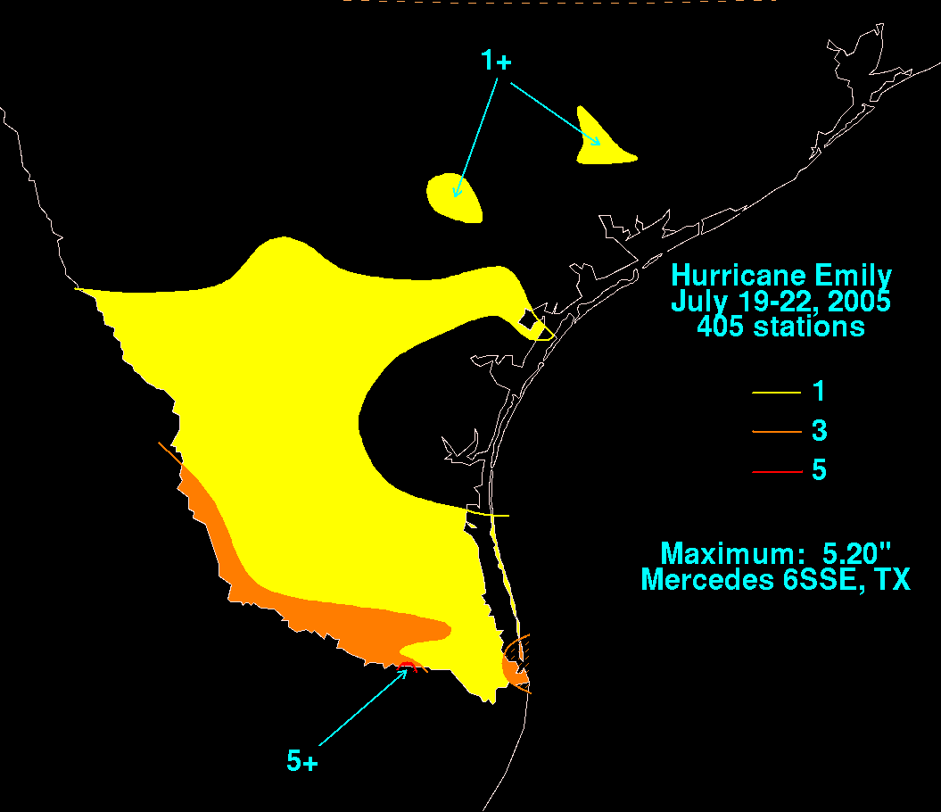 In southern Texas
, damage was relatively minor despite the proximity of the storm. Portions of the state experienced tropical storm force winds and gusts as high as 65 mph (100 km/h), resulting in scattered roof damage. Along the coast, a storm surge of 4.26 ft (1.3 m) flooded portions of Texas State Highway 100. No significant structural damage was reported, although some trees were down and over 30,000 customers lost electricity. Rainfall from the storm peaked at 5.2 inches in Mercedes, Texas
. Additionally, eight tornadoes touched down in Texas as a result of Emily, damaging or destroying several homes. Some positive effects were noted; the remains of Emily passed farther west into Texas and delivered some badly needed rainfall, helping relieve a drought. Agricultural losses in Texas amounted to $4.7 million, while property losses reached $225,000.
The National Hurricane Center's archive on Hurricane Emily
Atlantic hurricane season
The Atlantic hurricane season is the period in a year when hurricanes usually form in the Atlantic Ocean. Tropical cyclones in the North Atlantic are called hurricanes, tropical storms, or tropical depressions. In addition, there have been several storms over the years that have not been fully...
tropical cyclone
Tropical cyclone
A tropical cyclone is a storm system characterized by a large low-pressure center and numerous thunderstorms that produce strong winds and heavy rain. Tropical cyclones strengthen when water evaporated from the ocean is released as the saturated air rises, resulting in condensation of water vapor...
that caused significant damage across the Caribbean Sea
Caribbean Sea
The Caribbean Sea is a sea of the Atlantic Ocean located in the tropics of the Western hemisphere. It is bounded by Mexico and Central America to the west and southwest, to the north by the Greater Antilles, and to the east by the Lesser Antilles....
to Mexico
Mexico
The United Mexican States , commonly known as Mexico , is a federal constitutional republic in North America. It is bordered on the north by the United States; on the south and west by the Pacific Ocean; on the southeast by Guatemala, Belize, and the Caribbean Sea; and on the east by the Gulf of...
. A Cape Verde-type hurricane
Cape Verde-type hurricane
A Cape Verde-type hurricane is an Atlantic hurricane that develops near the Cape Verde islands, off the west coast of Africa. The average hurricane season has about two Cape Verde-type hurricanes, which are usually the largest and most intense storms of the season because they often have plenty of...
, the storm formed on July 10, 2005, in the central Atlantic Ocean before passing through the Windward Islands
Windward Islands
The Windward Islands are the southern islands of the Lesser Antilles, within the West Indies.-Name and geography:The Windward Islands are called such because they were more windward to sailing ships arriving in the New World than the Leeward Islands, given that the prevailing trade winds in the...
on July 14. Tracking generally towards the west-northwest, the storm gradually intensified as it traversed the Caribbean, peaking as a Category 5 hurricane on July 16, marking the earliest date for a storm to do so during the course of a given year. The system subsequently made landfall
Landfall (meteorology)
Landfall is the event of a tropical cyclone or a waterspout coming onto land after being over water. When a waterspout makes landfall it is reclassified as a tornado, which can then cause damage inland...
in the Yucatán Peninsula
Yucatán Peninsula
The Yucatán Peninsula, in southeastern Mexico, separates the Caribbean Sea from the Gulf of Mexico, with the northern coastline on the Yucatán Channel...
as a Category 4. Quickly crossing the peninsula, Emily emerged into the Gulf of Mexico
Gulf of Mexico
The Gulf of Mexico is a partially landlocked ocean basin largely surrounded by the North American continent and the island of Cuba. It is bounded on the northeast, north and northwest by the Gulf Coast of the United States, on the southwest and south by Mexico, and on the southeast by Cuba. In...
and reorganized. On July 20, the storm struck Tamaulipas
Tamaulipas
Tamaulipas officially Estado Libre y Soberano de Tamaulipas is one of the 31 states which, with the Federal District, comprise the 32 Federal Entities of Mexico. It is divided in 43 municipalities and its capital city is Ciudad Victoria. The capital city was named after Guadalupe Victoria, the...
as a major hurricane and rapidly dissipated within 24 hours.
When its central pressure fell to 929 mbar and its sustained winds reached 160 mph (260 km/h) on July 16, Emily became the strongest hurricane ever to form before August, breaking a record set by Hurricane Dennis
Hurricane Dennis
Hurricane Dennis was an early-forming major hurricane in the Caribbean and Gulf of Mexico during the very active 2005 Atlantic hurricane season. Dennis was the fourth named storm, second hurricane, and first major hurricane of the season...
just six days before. It was also the earliest Category 5 hurricane ever recorded in the Atlantic basin (beating Hurricane Allen
Hurricane Allen
Hurricane Allen was the first and strongest hurricane of the 1980 Atlantic hurricane season. It was one of the strongest hurricanes in recorded history, one of the few hurricanes to reach Category 5 status on the Saffir-Simpson Hurricane Scale on three separate occasions, and spent more time...
's old record by nearly three weeks) and the only Category 5 hurricane ever recorded before August.
Meteorological history
Tropical Depression Five formed in the central tropical Atlantic the evening of July 10. Late on July 11, it strengthened and was named Tropical Storm Emily. Initially forecast to strengthen rapidly and move west-northwest through the Greater AntillesGreater Antilles
The Greater Antilles are one of three island groups in the Caribbean. Comprising Cuba, Jamaica, Hispaniola , and Puerto Rico, the Greater Antilles constitute almost 90% of the land mass of the entire West Indies.-Greater Antilles in context :The islands of the Caribbean Sea, collectively known as...
, Emily instead moved almost due west toward the Windward Islands
Windward Islands
The Windward Islands are the southern islands of the Lesser Antilles, within the West Indies.-Name and geography:The Windward Islands are called such because they were more windward to sailing ships arriving in the New World than the Leeward Islands, given that the prevailing trade winds in the...
, remaining a moderate tropical storm. The storm languished while moving quickly west, and struggled with maintaining its form. Contrary to the normal occurrence that hurricanes leave a cold wake behind, Hurricane Dennis
Hurricane Dennis
Hurricane Dennis was an early-forming major hurricane in the Caribbean and Gulf of Mexico during the very active 2005 Atlantic hurricane season. Dennis was the fourth named storm, second hurricane, and first major hurricane of the season...
had made portions of the Caribbean Sea
Caribbean Sea
The Caribbean Sea is a sea of the Atlantic Ocean located in the tropics of the Western hemisphere. It is bounded by Mexico and Central America to the west and southwest, to the north by the Greater Antilles, and to the east by the Lesser Antilles....
warmer, and therefore more favorable for tropical cyclone development. Late on July 13, Emily strengthened rapidly and reached hurricane strength while passing Tobago
Tobago
Tobago is the smaller of the two main islands that make up the Republic of Trinidad and Tobago. It is located in the southern Caribbean, northeast of the island of Trinidad and southeast of Grenada. The island lies outside the hurricane belt...
and entering the eastern Caribbean. On July 14, Emily made landfall in northern Grenada
Grenada
Grenada is an island country and Commonwealth Realm consisting of the island of Grenada and six smaller islands at the southern end of the Grenadines in the southeastern Caribbean Sea...
with 90 mph (145 km/h) winds.
The intensification trend picked up again the next day with a fairly rapid drop in the storm's central pressure
Atmospheric pressure
Atmospheric pressure is the force per unit area exerted into a surface by the weight of air above that surface in the atmosphere of Earth . In most circumstances atmospheric pressure is closely approximated by the hydrostatic pressure caused by the weight of air above the measurement point...
as it entered the southeastern Caribbean Sea, a region typically unfavorable for intensification. Hurricane Emily's winds increased in reaction, briefly bringing the storm to Category 4 strength early on July 15. During the day, the storm's strength fluctuated greatly, dropping to a Category 2 storm and then rebuilding to Category 4. On July 16, Emily strengthened considerably, making it the strongest hurricane ever on record to form in the month of July with peak winds of 160 mph (260 km/h), the earliest known Category 5 in the Atlantic basin. Initially at this point Emily was thought to have peaked as a Category 4 storm, but the post-storm analysis showed it was indeed a Category 5 hurricane. The storm weakened slightly as it continued westward, and remained a Category 4 while passing south of Jamaica
Jamaica
Jamaica is an island nation of the Greater Antilles, in length, up to in width and 10,990 square kilometres in area. It is situated in the Caribbean Sea, about south of Cuba, and west of Hispaniola, the island harbouring the nation-states Haiti and the Dominican Republic...
and, on July 17, the Cayman Islands
Cayman Islands
The Cayman Islands is a British Overseas Territory and overseas territory of the European Union located in the western Caribbean Sea. The territory comprises the three islands of Grand Cayman, Cayman Brac, and Little Cayman, located south of Cuba and northwest of Jamaica...
. Hurricane Emily continued on its nearly straight track to the west-northwest, weakening somewhat but remaining at Category 4 until striking Cozumel
Cozumel
Cozumel is an island in the Caribbean Sea off the eastern coast of Mexico's Yucatan Peninsula, opposite Playa del Carmen, and close to the Yucatan Channel. Cozumel is one of the ten municipalities of the state of Quintana Roo...
just before mainland landfall at Playa del Carmen
Playa del Carmen
Playa del Carmen is a balneario resort city just south of Cancún on the coast of the Caribbean Sea, in the northeast of the Mexican state of Quintana Roo. The city is the seat of the Solidaridad municipality. In the 2010 census, the city had a population of 149,923 people and it is rapidly growing...
at 06:30 UTC on July 18. Sustained winds were 135 mph (215 km/h), and the eyewall passed directly over Cozumel.
Gulf of Mexico
The Gulf of Mexico is a partially landlocked ocean basin largely surrounded by the North American continent and the island of Cuba. It is bounded on the northeast, north and northwest by the Gulf Coast of the United States, on the southwest and south by Mexico, and on the southeast by Cuba. In...
later that morning. Passage over land disrupted the hurricane's center of circulation, and it had weakened to a minimal hurricane with wind speeds of 75 mph (120 km/h). However, several hours over the warm waters of the western Gulf provided the energy needed for Emily to regenerate, and by midnight wind speeds were increasing. The increase in wind speed stalled, but the storm continued to become better organized. Emily started to show very symmetrical outflow, but the hurricane's strongest winds were being found at three different distances from the center. However, the outer wind radii subsided in the end, and the inner core prevailed. The result was a rapid strengthening of the inner core on the evening of July 19. The pressure dropped about 30 millibars and the winds went from 90 mph (145 km/h) to more than 125 mph (200 km/h), all within a few hours.
Further strengthening was expected by forecasters, but did not come. The storm's motion slowed, and the center began wobbling erratically toward the coast. The storm made landfall around 11:00 UTC on July 20 near San Fernando
San Fernando, Tamaulipas
San Fernando is a municipality and city located in the Mexican state of Tamaulipas.-Massacres:San Fernando, Tamaulipas is notorious for experiencing two of the largest recorded massacres of the Mexican Drug War...
in Tamaulipas
Tamaulipas
Tamaulipas officially Estado Libre y Soberano de Tamaulipas is one of the 31 states which, with the Federal District, comprise the 32 Federal Entities of Mexico. It is divided in 43 municipalities and its capital city is Ciudad Victoria. The capital city was named after Guadalupe Victoria, the...
. The storm had sustained winds of 125 mph (200 km/h), Category 3 on the Saffir-Simpson Hurricane Scale. After heading inland over northeast Mexico, it dissipated over the Sierra Madre Oriental
Sierra Madre Oriental
The Sierra Madre Oriental is a mountain range in northeastern Mexico.-Setting:Spanning the Sierra Madre Oriental runs from Coahuila south through Nuevo León, southwest Tamaulipas, San Luis Potosí, Querétaro, and Hidalgo to northern Puebla, where it joins with the east-west running Eje Volcánico...
on July 21.
Preparations
In Mexico, tens of thousands of tourists and residents were evacuated from the beach resorts in and around CancúnCancún
Cancún is a city of international tourism development certified by the UNWTO . Located on the northeast coast of Quintana Roo in southern Mexico, more than 1,700 km from Mexico City, the Project began operations in 1974 as Integrally Planned Center, a pioneer of FONATUR Cancún is a city of...
, the Riviera Maya, and Cozumel
Cozumel
Cozumel is an island in the Caribbean Sea off the eastern coast of Mexico's Yucatan Peninsula, opposite Playa del Carmen, and close to the Yucatan Channel. Cozumel is one of the ten municipalities of the state of Quintana Roo...
. Hotel guests were evacuated on Saturday afternoon, and staff on Sunday afternoon. Though some hotel guests in second floor rooms and above were given the option to be bussed into the center of Cancun to safe houses and shelters or to stay and wait out the storm in only the modern built hotels and resorts. Most of the remaining guests were restricted to their rooms and were not allowed out on the beach areas. No alcohol was sold in Cancun for 36 hours prior to the arrival of the storm, in an attempt to avoid drunken tourists being injured during the night. Two helicopter
Helicopter
A helicopter is a type of rotorcraft in which lift and thrust are supplied by one or more engine-driven rotors. This allows the helicopter to take off and land vertically, to hover, and to fly forwards, backwards, and laterally...
pilots were killed when their aircraft crashed while evacuating offshore oil platform
Oil platform
An oil platform, also referred to as an offshore platform or, somewhat incorrectly, oil rig, is a lаrge structure with facilities to drill wells, to extract and process oil and natural gas, and to temporarily store product until it can be brought to shore for refining and marketing...
s operated by Pemex
Pemex
Petróleos Mexicanos or Pemex is a Mexican state-owned petroleum company. As of 2010, with a total asset worth of $415.75 billion, it is the second non-publicly listed largest company in the world by total market value, and Latin America's second largest enterprise by annual revenue as of 2009...
. A German resident was electrocuted while on his roof in Playa del Carmen
Playa del Carmen
Playa del Carmen is a balneario resort city just south of Cancún on the coast of the Caribbean Sea, in the northeast of the Mexican state of Quintana Roo. The city is the seat of the Solidaridad municipality. In the 2010 census, the city had a population of 149,923 people and it is rapidly growing...
.
Caribbean
On July 14, Emily hit GrenadaGrenada
Grenada is an island country and Commonwealth Realm consisting of the island of Grenada and six smaller islands at the southern end of the Grenadines in the southeastern Caribbean Sea...
which was still recovering from the impact of Hurricane Ivan
Hurricane Ivan
Hurricane Ivan was a large, long-lived, Cape Verde-type hurricane that caused widespread damage in the Caribbean and United States. The cyclone was the ninth named storm, the sixth hurricane and the fourth major hurricane of the active 2004 Atlantic hurricane season...
less than a year earlier. Emily resulted in one reported fatality and significant damage in the northern part of the country, including Carriacou which had been spared the worst effects of Ivan. 16 houses were destroyed and well over 200 more were damaged, and two of the main hospitals were flooded. Damages in Grenada amounted to $110.4 million.
Landslides were reported in eastern Jamaica
Jamaica
Jamaica is an island nation of the Greater Antilles, in length, up to in width and 10,990 square kilometres in area. It is situated in the Caribbean Sea, about south of Cuba, and west of Hispaniola, the island harbouring the nation-states Haiti and the Dominican Republic...
, triggered by heavy rain as the storm passed south of the island. Five people were killed due to an accident caused by flash flooding. Damages in Jamaica were estimated at $65 million. Damage was also reported in Trinidad and Tobago
Trinidad and Tobago
Trinidad and Tobago officially the Republic of Trinidad and Tobago is an archipelagic state in the southern Caribbean, lying just off the coast of northeastern Venezuela and south of Grenada in the Lesser Antilles...
, where landslides and flooding damaged several homes. In Honduras
Honduras
Honduras is a republic in Central America. It was previously known as Spanish Honduras to differentiate it from British Honduras, which became the modern-day state of Belize...
, a man drowned in a river swollen by rains from Emily.
Mexico
| Country | Fatalities | Damage (USD) |
| Grenada Grenada Grenada is an island country and Commonwealth Realm consisting of the island of Grenada and six smaller islands at the southern end of the Grenadines in the southeastern Caribbean Sea... |
1 | $110.4 million |
| Jamaica Jamaica Jamaica is an island nation of the Greater Antilles, in length, up to in width and 10,990 square kilometres in area. It is situated in the Caribbean Sea, about south of Cuba, and west of Hispaniola, the island harbouring the nation-states Haiti and the Dominican Republic... |
5 | $65 million |
| Haiti Haiti Haiti , officially the Republic of Haiti , is a Caribbean country. It occupies the western, smaller portion of the island of Hispaniola, in the Greater Antillean archipelago, which it shares with the Dominican Republic. Ayiti was the indigenous Taíno or Amerindian name for the island... |
5 | N/A |
| Honduras Honduras Honduras is a republic in Central America. It was previously known as Spanish Honduras to differentiate it from British Honduras, which became the modern-day state of Belize... |
1 | N/A |
| Mexico Mexico The United Mexican States , commonly known as Mexico , is a federal constitutional republic in North America. It is bordered on the north by the United States; on the south and west by the Pacific Ocean; on the southeast by Guatemala, Belize, and the Caribbean Sea; and on the east by the Gulf of... |
5 | $834.3 million |
| United States United States The United States of America is a federal constitutional republic comprising fifty states and a federal district... |
0 | $4.8 million |
| Total | 17 | $1.014 billion |
Yucatán Peninsula
Striking the Yucatán Peninsula on July 18 as a Category 4 hurricane, widespread damage was expected from 135 mph (215 km/h) winds; however, these winds were confined to a small area around Emily's center. Areas in Playa del Carmen, Tulum and Cozumel sustained the most severe impact. In a few instances, concrete utility poles were snapped in half by powerful wind gusts. Due to the relatively fast movement of Emily, rainfall was fairly light, peaking at 4.9 in (124.5 mm). Few meteorological reports exist during Emily's passage of the Yucatán, though an unofficial station recorded a storm surgeStorm surge
A storm surge is an offshore rise of water associated with a low pressure weather system, typically tropical cyclones and strong extratropical cyclones. Storm surges are caused primarily by high winds pushing on the ocean's surface. The wind causes the water to pile up higher than the ordinary sea...
of 15 ft (4.6 m) in San Miguil, Cozumel. Along the mainland, surge heights were generally less than 4 ft (1 m). Additionally, waves reached 13 ft (4 m), resulting in some beach erosion and damage to dunes and coral reef
Coral reef
Coral reefs are underwater structures made from calcium carbonate secreted by corals. Coral reefs are colonies of tiny living animals found in marine waters that contain few nutrients. Most coral reefs are built from stony corals, which in turn consist of polyps that cluster in groups. The polyps...
s. Additionally, 0.7 mi (1.1 km) of retaining walls sustained damage, leaving areas vulnerable to flooding from future storms.
The high winds produced by Emily caused considerable impact in Quintana Roo
Quintana Roo
Quintana Roo officially Estado Libre y Soberano de Quintana Roo is one of the 31 states which, with the Federal District, comprise the 32 Federal Entities of Mexico. It is divided in 10 municipalities and its capital city is Chetumal....
, especially in the municipality of Solidaridad
Solidaridad, Quintana Roo
Solidaridad is one of the ten municipalities that make up the Mexican state of Quintana Roo. It is also one of the youngest municipalities in the country and was formed on July 28 of 1993 by decree of the State Congress during the administration of Mario Villanueva Madrid...
, leaving nearly 200,000 residences without power. In terms of structural damage, 851 homes were impacted in varying degrees. Roughly 13,345 acres (5,400 hectares) of forests and agricultural land was affected by the storm; some swathes of trees experienced defoliation. The most substantial losses associated with the hurricane stemmed from the tourism industry, with hotels experiencing 947 million pesos ($88.7 million) worth of damage. More than 12,500 rooms, nearly one-fifth of the state's available hotel infrastructure, sustained damage. Overall, damage in the state reached 1.11 billion pesos ($104.3 million).
Northeastern Mexico
Emily's second landfall as a strong Category 3 hurricane brought significant damage to the northeast coast of Mexico. In the fishing community of Laguna Madre, over 80% of the buildings were destroyed as a result of the storm surgeStorm surge
A storm surge is an offshore rise of water associated with a low pressure weather system, typically tropical cyclones and strong extratropical cyclones. Storm surges are caused primarily by high winds pushing on the ocean's surface. The wind causes the water to pile up higher than the ordinary sea...
. Several communities on the remote coast of Tamaulipas
Tamaulipas
Tamaulipas officially Estado Libre y Soberano de Tamaulipas is one of the 31 states which, with the Federal District, comprise the 32 Federal Entities of Mexico. It is divided in 43 municipalities and its capital city is Ciudad Victoria. The capital city was named after Guadalupe Victoria, the...
were isolated after the storm, and major coastal flooding was reported along with heavy wind damage, with numerous homes destroyed. Inland flooding was also reported in Monterrey
Monterrey
Monterrey , is the capital city of the northeastern state of Nuevo León in the country of Mexico. The city is anchor to the third-largest metropolitan area in Mexico and is ranked as the ninth-largest city in the nation. Monterrey serves as a commercial center in the north of the country and is the...
.
Communication to the Riviera Maya area was difficult after the storm; not all cellular phones were receiving coverage to the area, land lines were down, and electricity was out. About 18,000 people in 20 low-lying communities in the state of Tamaulipas
Tamaulipas
Tamaulipas officially Estado Libre y Soberano de Tamaulipas is one of the 31 states which, with the Federal District, comprise the 32 Federal Entities of Mexico. It is divided in 43 municipalities and its capital city is Ciudad Victoria. The capital city was named after Guadalupe Victoria, the...
, just south of the U.S.-Mexican border, were evacuated. Including losses sustained by the oil industry, damage in Mexico amounted to 8.87 billion pesos ($834.3 million).
Texas
Texas
Texas is the second largest U.S. state by both area and population, and the largest state by area in the contiguous United States.The name, based on the Caddo word "Tejas" meaning "friends" or "allies", was applied by the Spanish to the Caddo themselves and to the region of their settlement in...
, damage was relatively minor despite the proximity of the storm. Portions of the state experienced tropical storm force winds and gusts as high as 65 mph (100 km/h), resulting in scattered roof damage. Along the coast, a storm surge of 4.26 ft (1.3 m) flooded portions of Texas State Highway 100. No significant structural damage was reported, although some trees were down and over 30,000 customers lost electricity. Rainfall from the storm peaked at 5.2 inches in Mercedes, Texas
Mercedes, Texas
Mercedes is a city in Hidalgo County, Texas, United States. The population was 15,570 at the 2010 census. It is part of the McAllen–Edinburg–Mission and Reynosa–McAllen metropolitan areas.-Geography:Mercedes is located at ....
. Additionally, eight tornadoes touched down in Texas as a result of Emily, damaging or destroying several homes. Some positive effects were noted; the remains of Emily passed farther west into Texas and delivered some badly needed rainfall, helping relieve a drought. Agricultural losses in Texas amounted to $4.7 million, while property losses reached $225,000.
See also
- 2005 Atlantic hurricane season2005 Atlantic hurricane seasonThe 2005 Atlantic hurricane season was the most active Atlantic hurricane season in recorded history, repeatedly shattering numerous records. The impact of the season was widespread and ruinous with an estimated 3,913 deaths and record damage of about $159.2 billion...
- Timeline of the 2005 Atlantic hurricane seasonTimeline of the 2005 Atlantic hurricane seasonThe timeline of the 2005 Atlantic hurricane season documents the formations, strengthenings, weakenings, landfalls, extratropical transitions, and dissipations of the season's tropical and subtropical storms. The 2005 Atlantic hurricane season was the most active Atlantic hurricane season in...
- List of storms in the 2005 Atlantic hurricane season
- List of Category 5 Atlantic hurricanes